
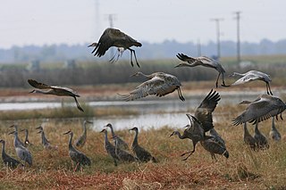
The sandhill crane is a species of large crane of North America and extreme northeastern Siberia. The common name of this bird refers to habitat like that at the Platte River, on the edge of Nebraska's Sandhills on the American Plains. This is the most important stopover area for the nominotypical subspecies, the lesser sandhill crane, with up to 450,000 of these birds migrating through annually.

The Sandhills, often written Sand Hills, is a region of mixed-grass prairie on grass-stabilized sand dunes in north-central Nebraska, covering just over one quarter of the state. The dunes were designated a National Natural Landmark in 1984.

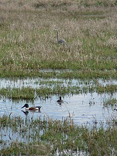
The Ruby Lake National Wildlife Refuge is located in southwestern Elko County and northwestern White Pine County in the northeastern section of the state of Nevada in the western United States. Established in 1938, it encompasses 37,632 acres (152.29 km2) of wetlands in Ruby Valley, just east of the Ruby Mountains and just south of Harrison Pass. It is 16 miles (26 km) long, up to 3 miles (4.8 km) in width, and lies at an elevation of 6,000 feet (1,800 m). Once the bed of a 200-foot (61 m) deep lake, it is now a network of spring-fed marshes and shallow ponds serving as a habitat for hundreds of species of native and migratory birds and mammals.

Monte Vista National Wildlife Refuge is a United States National Wildlife Refuge located in southern Colorado. The refuge is located in the San Luis Valley south of the town of Monte Vista, Colorado in southeastern Rio Grande County, Colorado, in the watershed of the Rio Grande. It was established in 1953 by the Migratory Bird Conservation Commission to provide a habitat for wildlife, particularly waterfowl, in the San Luis Valley.
Ridgefield National Wildlife Refuge is a wildlife preserve, one of the national wildlife refuges operated by the United States Fish and Wildlife Service, located in the westernmost part of Clark County, Washington. The refuge protects more than 5,200 acres (2,100 ha) of marshes, grasslands, and woodlands. The refuge was established in 1965, in response to a need to establish vital winter habitat for wintering waterfowl with an emphasis on the dusky Canada goose whose nesting areas in Alaska were severely impacted by the violent earthquake of 1964. Ridgefield NWR is part of the Ridgefield National Wildlife Refuge Complex, headquartered in Ridgefield, Washington, which oversees the management of four refuges in the southwestern part of the state: Ridgefield, and three refuges in the Columbia River Gorge: Franz Lake, Pierce, and Steigerwald Lake. This place was closed in spring of 2019 to cut down Douglas fir and change the trail. In fall of 2020, the construction of a new multi-purpose building began. The new multi-purpose building will be a construction type V-B and consist of a 4,415 square foot single story building with an associated balcony and basement area. The building is being constructed to provide the fish and wildlife staff office space, meeting space, and an area for public visitors including volunteers and conservation partners.

The Seney National Wildlife Refuge is a managed wetland in Schoolcraft County in the U.S. state of Michigan. It has an area of 95,212 acres (385 km2). It is bordered by M-28 and M-77. The nearest town of any size is Seney, Michigan. The refuge contains the Seney Wilderness Area and the Strangmoor Bog National Natural Landmark within its boundaries.
Lacreek National Wildlife Refuge is a National Wildlife Refuge of the United States located in South Dakota. It covers 16,410 acres (66.4 km2) and is managed by the United States Fish and Wildlife Service.

The Tualatin River National Wildlife Refuge is a 1,856 acres (751 ha) wetlands and lowlands sanctuary in the northwestern part of the U.S. state of Oregon. Established in 1992 and opened to the public in 2006, it is managed by the United States Fish and Wildlife Service. Located in southeastern Washington County, 15 miles (24 km) southwest of Portland, the refuge is bordered by Sherwood, Tualatin and Tigard. A newer area, extending into northern Yamhill County, is located further west near the city of Gaston surrounding the former Wapato Lake.
Grays Lake is a wetland in Idaho, United States. It lies in Bonneville County and Caribou County. Grays Lake National Wildlife Refuge was established in the area in 1965. Ranching is the predominant use of surrounding lands.

Glacial Ridge National Wildlife Refuge was created on October 12, 2004, the 545th National Wildlife Refuge in the United States. Its creation was the result of cooperation between at least 30 agencies or governmental entities. The creation of the refuge was spearheaded by The Nature Conservancy, and the initial endowment of 2,300 acres (9.3 km2) of land was donated by the Conservancy. In light of its planned final size of 37,756 acres (153 km2), it is described by the US Fish and Wildlife Service as "the largest tallgrass prairie and wetland restoration project in U.S. history."
The San Luis National Wildlife Refuge Complex is located in the northern San Joaquin Valley, within Merced County and Stanislaus County of California. The complex, with four federal National Wildlife Refuges, is managed by the U.S Fish & Wildlife Service.

The Sonny Bono Salton Sea National Wildlife Refuge is located in California's Imperial Valley, 40 miles (64 km) north of the Mexican border. Situated at the southern end of the Salton Sea, the refuge protects one of the most important nesting sites and stopovers along the Pacific Flyway. Despite its location in the Colorado Desert, a subdivision of the larger Sonoran Desert, the refuge contains marine, freshwater, wetland, and agricultural habitats which provide sanctuary for hundreds of birds and wetland species, including several that have been listed as endangered or sensitive by the U.S. Fish and Wildlife Service.

Grays Lake National Wildlife Refuge is a National Wildlife Refuge of the United States located in southeastern Idaho. It has the largest hardstem bulrush marsh in North America. Located in a high mountain valley near Soda Springs, the refuge and surrounding mountains offer scenic vistas, wildflowers, and fall foliage displays. Lands adjacent to the 19,400-acre (79 km2) refuge are primarily wet meadows and grasslands. The refuge provides breeding habitat for species of mammals including moose, elk, mule deer, muskrat, badger, and weasel.

Crane Meadows National Wildlife Refuge was established in 1992 to preserve a large, natural wetland complex. The refuge is located in central Minnesota and serves as an important stop for many species of migrating birds. Located within a large watershed that includes Rice, Skunk and Mud Lakes, Platte and Skunk Rivers, Rice and Buckman Creeks, and sedge meadow wetlands, it harbors one of the largest nesting populations of greater sandhill cranes in Minnesota. Habitats include native tallgrass prairie, oak savanna, and wetlands with stands of wild rice. With a total authorized acquisition boundary of 13,540 acres (54.8 km2) encompassing this important wetland complex and adjacent uplands, Crane Meadows National Wildlife Refuge presently exists as scattered parcels totaling about 2,000 acres (8.1 km2). Existing ownership lies in Little Falls Township and Agram Township in Morrison County.

Located in Coos County, New Hampshire and Oxford County, Maine, Umbagog National Wildlife Refuge is a northern treasure in the National Wildlife Refuge System. The diversity of exceptional habitats provides excellent breeding and foraging areas for migratory birds, endangered species, resident wildlife, and rare plants. The refuge protects over 25,650 acres (103.8 km2) of wetland and forested upland habitat along Umbagog Lake. About 70% of its area is in New Hampshire and 30% in Maine.

Conboy Lake National Wildlife Refuge is located on the east slope of the Cascade Mountains at the base of 12,281-foot (3,743 m) Mount Adams in southern Washington state.

The Stone Lakes National Wildlife Refuge, located south of Sacramento, California, lies within the Sacramento-San Joaquin delta, the destination of thousands of migrating waterfowl, shorebirds, and other water birds. The refuge was established in 1994.
The Merced National Wildlife Refuge encompasses 10,262 acres (41.53 km2) of wetlands, native grasslands, vernal pools, and riparian areas in California. It was established in 1951 under the Lea Act to attract wintering waterfowl from adjacent farmland where their foraging was causing crop damage. In the last few decades, changes in agricultural practices and refuge management have reduced these wildlife/crop issues.

The Summer Lake Wildlife Area is a 29.6-square-mile (77 km2) wildlife refuge located on the northwestern edge of the Great Basin drainage in south-central Oregon. It is administered by the Oregon Department of Fish and Wildlife. The refuge is an important stop for waterfowl traveling along the Pacific Flyway during their spring and fall migrations. The Summer Lake Wildlife Area also provides habitat for shorebirds and other bird species as well as wide variety of mammals and several fish species. The Ana River supplies the water for the refuge wetlands.
Salt Creek Wilderness is a designated Wilderness Area located on the Pecos River approximately 12 miles north-east of Roswell, New Mexico. Established in 1970 as a unit of the Bitter Lake National Wildlife Refuge, the 9,621 acre Wilderness is administered by the U. S Fish and Wildlife Service. Combining the scrub lands of the Chihuahuan Desert with the riparian environment of the Pecos River and the Artesian basin of eastern New Mexico, Salt Creek represents a rare convergence of desert and wetlands.


