West Malpais Wilderness

Last updated
West Malpais Wilderness
Usa edcp relief location map.png
Red pog.svg
Location Cibola County, New Mexico, United States
Nearest city Grants
Coordinates 34°53′24.6″N108°09′30.4″W / 34.890167°N 108.158444°W / 34.890167; -108.158444 Coordinates: 34°53′24.6″N108°09′30.4″W / 34.890167°N 108.158444°W / 34.890167; -108.158444
Area35,940 acres (145.4 km2)
Established1987
Governing body United States Bureau of Land Management
Website West Malpais Wilderness

West Malpais Wilderness is a designated Wilderness Area managed by the U. S. Bureau of Land Management [BLM] located south of Grants, NM in Cibola County, New Mexico. Established in 1987, the 35,940-acre West Malpais Wilderness is located within the larger El Malpais National Conservation Area, a 231,230-acre BLM-managed area created in 1987 to protect the Grants Lava Flow, the Las Ventanas Chacoan Archeological Site, and other significant natural and cultural resources in Western New Mexico. One of two Wilderness Areas in the Conservation Area, the 35,940 acre West Malpais area is open to hiking, backpacking, horseback riding, and "Leave No Trace" primitive camping, and contains a short section of the Continental Divide National Scenic Trail. [1]

Contents

History and Administration

The West Malpais Wilderness was created on December 31, 1987, with the passage of Public Law 100-225 by the 100th Congress. An important piece of public lands legislation, the law created not only the West Malpais Wilderness, but also created the 231,230 acre El Malpais National Conservation Area, the El Malpais National Monument, the Cebolla Wilderness, and the Masau Trail. [1] In common with the larger Conservation Area and the nearby Cebolla Wilderness, West Malpais is administered by the Bureau of Land Management [BLM], and is managed as part of the BLM's Rio Puerco Field Office, located in Albuquerque, NM. [2]

Geography and Climate

Mostly flat, and with elevations ranging from 7,000 to 7600 feet, the West Malpais Wilderness was shaped by countless volcanic eruptions, whose rivers of molten rock and flying cinders produced a landscape of craters, lava tubes, cinder cones, and pressure ridges. One of the most notable of these environmental elements is a 6,700-acre kipuka (a geological term describing an area of land surrounded by lava flows) in the northern half of the wilderness known as "Hole-In-The-Wall", where spreading waves of volcanic rock surround an island of ponderosa pine. A dry and hot environment known for high winds, the Wilderness sees high temperatures of 89 degrees Fahrenheit in July, average low temperatures in December around 20 degrees, and an average annual precipitation of 14 inches. [1]

Flora and Fauna

Despite its volcanic origins and harsh climate, West Malpais contains many types of vegetation, as wind-deposited debris has thickened enough over the centuries to support many species of plant life. In the open southeastern portion of the wilderness, grasses and cacti dominate, while pinon and juniper can be found in the woodlands in the western areas and Ponderosa pine in the northern portion of the Wilderness. Common wildlife within the Wilderness includes antelopes, deer, rabbits, squirrels, coyotes, and red-tailed hawks. In the summer months a large colony of Mexican free-tailed bats migrates between the many caves that dot the lava fields. [3]

Location and Access

Since the Wilderness shares much of its northern and eastern borders with the El Malpais National Monument, access to the area is along CR 42, which forms the southern and western borders of the Wilderness. A developed trail head, which leads into the Hole-in-the-Wall area, is located on CR 42 and can be accessed from the north via NM 53 SW of Grants, or from the east via NM 117 S of Grants. An unpaved road, CR 42 can be rendered difficult or impassible during times of wet weather and care should be taken to obtain current road conditions before visiting. [1]

Recreation

Like all Wilderness Areas, West Malpais is closed to all mechanized and motorized vehicles, including mountain bicycles. The Wilderness is open to hiking, backpacking, horseback riding, and "Leave-No-Trace" primitive camping. There are no permanent facilities in the Wilderness, and the only developed areas other than trail heads are the system of trails leading to the Hole-in-the-Wall area and the short section of the Continental Divide Trail that crosses the southern portion of the Wilderness. Trips into the Wilderness require a backcountry permit, which can be obtained from the El Malpais Information Center in Grants, or from the BLM Ranger Station on NM 117. [4] As might be expected from a desert environment known as the "Badlands," the Wilderness has no water sources, so hikers and backpackers need to plan accordingly and be prepared to carry adequate supplies of water. [2]

Nearby Attractions

La Ventana Natural Arch, El Malpais N.C.A. El Malpais NM Ventana Arch.jpg
La Ventana Natural Arch, El Malpais N.C.A.

As previously noted, the West Malpais Wilderness is located within the 231,230 acre El Malpais National Conservation Area, a Bureau of Land Management area established at the same time as the Wilderness. The Conservation Area includes one primitive campground, several small picnic areas,


Immediately east of the Wilderness is El Malpais National Monument, a National Park Service-administered area created at the same time as the Conservation Area and the Wilderness. A fee-free area, the National Monument offers opportunities for hiking, scenic drives, and "Leave No Trace" primitive camping. Approximately 30 miles of the Continental Divide National Scenic Trail runs through the Monument and adjacent Conservation Area lands. [5] El Malpais National Monument (U.S. National Park Service) The Monument can be reached via NM 53 just east of Grants, or by NM 117, from I-40, approximately 12 miles S of Grants. East and South of NM 117 lies the Conservation Area's other Wilderness Area, the 61,600-acre Cebolla Wilderness. An area of considerable archaeological interest, Cebolla is considerably easier to access than West Malpais Wilderness, and contains several developed trails and a number of developed trail heads along NM 117. Like West Malpais, Cebolla is open to hiking, backpacking, horseback riding, and "Leave No Trace" primitive camping. [6] West of the Wilderness, along NM 53 is El Morro National Monument, a National Park Service-administered area... Another fee-free park, El Morro has a small developed campground, a rarity in the area. A year-round, first-come, first-served campground, the 9-site area offers vaulted-toilets and seasonal water. [7]

See also

Related Research Articles

<span class="mw-page-title-main">Craters of the Moon National Monument and Preserve</span> National monument in Idaho, United States

Craters of the Moon National Monument and Preserve is a U.S. national monument and national preserve in the Snake River Plain in central Idaho. It is along US 20, between the small towns of Arco and Carey, at an average elevation of 5,900 feet (1,800 m) above sea level.

<span class="mw-page-title-main">El Malpais National Monument</span> National monument in New Mexico, United States

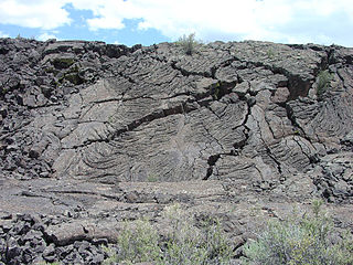
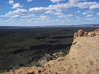
El Malpais National Monument is a National Monument located in western New Mexico, in the Southwestern United States. The name El Malpais is from the Spanish term Malpaís, meaning badlands, due to the extremely barren and dramatic volcanic field that covers much of the park's area.

<span class="mw-page-title-main">Lassen National Forest</span> United States national forest

Lassen National Forest is a United States national forest of 1,700 square miles (4,300 km2) in northeastern California. It is named after pioneer Peter Lassen, who mined, ranched and promoted the area to emigrant parties in the 1850s.

<span class="mw-page-title-main">National Conservation Lands</span> Group of federally-managed protected areas in the United States

National Conservation Lands, formally known as the National Landscape Conservation System, is a 35-million-acre (140,000 km2) collection of lands in 873 federally recognized areas considered to be the crown jewels of the American West. These lands represent 10% of the 258 million acres (1,040,000 km2) managed by the Bureau of Land Management (BLM). The BLM is the largest federal public land manager and is responsible for over 40% of all the federal public land in the nation. The other major federal public land managers include the US Forest Service (USFS), National Park Service (NPS), and the US Fish and Wildlife Service (USFWS).

<span class="mw-page-title-main">Black Ridge Canyons Wilderness</span> Wilderness area

The Black Ridge Canyons Wilderness (BRCW) is located in western Colorado with a small portion extending into eastern Utah, USA, within the arid Colorado Plateau region approximately 15 miles (24 km) west of Grand Junction, Colorado. The wilderness lies on the northwest flank of the Uncompahgre Plateau. It is characterized by the high, east-west trending Black Ridge dissected by seven major canyon systems, draining into the Colorado River in Ruby Canyon. Elevations range from 4,700 feet (1,400 m) above sea level along the river to 6,800 feet (2,070 m). Canyons vary in length from several miles to twelve miles in length and may contain interesting side canyons. Geological features in these canyons include spires, windows, giant alcoves and desert varnish. Canyons may reach a depth of almost 1,000 feet (300 m), forming spectacular red rock cliffs. Spring runoff and summer thunderstorms create glistening waterfalls and plunge pools. Rattlesnake Canyon contains the second largest concentration of natural arches in the country. Mee Canyon is even more remote, and contains Arch Tower.

<span class="mw-page-title-main">Santa Rosa and San Jacinto Mountains National Monument</span> Protected area in California

The Santa Rosa and San Jacinto Mountains National Monument is a National Monument in southern California. It includes portions of the Santa Rosa and San Jacinto mountain ranges, the northernmost ones of the Peninsular Ranges system. The national monument covers portions of Riverside County, west of the Coachella Valley, approximately 100 miles (160 km) southeast of downtown Los Angeles.

<span class="mw-page-title-main">McInnis Canyons National Conservation Area</span> National Conservation Area

The McInnis Canyons National Conservation Area (MCNCA) is a 123,400-acre (499 km2) National Conservation Area located in Mesa County, west of Grand Junction, Colorado. The MCNCA has rugged sandstone canyons, natural arches, spires, and alcoves carved into the Colorado Plateau, through which runs a 24-mile (39 km) stretch of the Colorado River. Included in the MCNCA is the 75,500-acre (306 km2) Black Ridge Canyons Wilderness (BRCW) with 5,200 acres (21 km2) extending into eastern Grand County, Utah at the MCNCA's western boundary.

<span class="mw-page-title-main">Sacatar Trail Wilderness</span> Protected wilderness area in California, United States

The Sacatar Trail Wilderness is a federally designated wilderness area located 20 miles (32 km) northwest of Ridgecrest, California USA. It was created in 1994 with the passage of the California Desert Protection Act - Public Law 103-433 - and is managed by the Bureau of Land Management (BLM). The wilderness is 51,900 acres (210 km2) in size and protects portions of the southern Sierra Nevada Mountain Range.

Cactus Plain is a plain east of the Colorado River and Parker Valley, in La Paz County, western Arizona, United States.

<span class="mw-page-title-main">Chimney Peak Wilderness</span> Protected wilderness area in California, United States

The Chimney Peak Wilderness is a 13,134-acre (53.15 km2) wilderness area located 20 miles (32 km) northwest of Ridgecrest, in southeastern Tulare County, California.

<span class="mw-page-title-main">Oregon Badlands Wilderness</span> Wilderness area in Oregon, United States

The Oregon Badlands Wilderness is a 29,301-acre (11,858 ha) wilderness area located east of Bend in Deschutes and Crook counties in the U.S. state of Oregon. The wilderness is managed by the Bureau of Land Management as part of the National Landscape Conservation System and was created by the Omnibus Public Land Management Act of 2009, which was signed into law by President Barack Obama on 30 March 2009.

<span class="mw-page-title-main">Santa Rosa Wilderness</span> Protected wilderness area in California, United States

The Santa Rosa Wilderness is a 72,259-acre (292.42 km2) wilderness area in Southern California, in the Santa Rosa Mountains of Riverside and San Diego counties, California. It is in the Colorado Desert section of the Sonoran Desert, above the Coachella Valley and Lower Colorado River Valley regions in a Peninsular Range, between La Quinta to the north and Anza Borrego Desert State Park to the south. The United States Congress established the wilderness in 1984 with the passage of the California Wilderness Act, managed by both the US Forest Service and the Bureau of Land Management. In 2009, the Omnibus Public Land Management Act was signed into law which added more than 2,000 acres (8.1 km2). Most of the Santa Rosa Wilderness is within the Santa Rosa and San Jacinto Mountains National Monument.

<span class="mw-page-title-main">El Malpais National Conservation Area</span> Protected area in New Mexico, United States

The El Malpais National Conservation Area is a federally protected conservation area in the U.S. state of New Mexico. The El Malpais National Conservation area was established in 1987 and is managed by the Bureau of Land Management as part of the National Landscape Conservation System. The adjoining El Malpais National Monument was established at the same time and is managed by the National Park Service.

Sleeping Giant Wilderness Study Area is a non-motorized recreation area located on the west side of the Missouri River and Holter Lake located about 30 miles (48 km) north of Helena, Montana. Designated as a wilderness study area in 1981, the Sleeping Giant Wilderness Study Area contains approximately 6,666 acres (2,698 ha) of nearly roadless land, about half of which is forested. A portion of the Lewis and Clark National Historic Trail is contained inside the study area.

<span class="mw-page-title-main">White Mountain Wilderness</span>

The White Mountain Wilderness is a 46,963 acre designated wilderness area managed by the United States Forest Service. Located in the Smokey Bear Ranger District of the Lincoln National Forest, the White Mountain Wilderness lies in the Sierra Blanca mountains of south central New Mexico, approximately 15 miles (24 km) north northwest of the town of Ruidoso.

<span class="mw-page-title-main">Lower White River Wilderness</span> Protected wilderness in the US State of Oregon

Lower White River Wilderness is a protected wilderness in the US State of Oregon on the southern part of Mount Hood. In 2009, Congress designated the area a National Wilderness preserve.

<span class="mw-page-title-main">Rio Grande del Norte National Monument</span>

The Rio Grande del Norte National Monument is an approximately 242,555-acre (98,159 ha) area of public lands in Taos County, New Mexico, proclaimed as a national monument on March 25, 2013, by President Barack Obama under the provisions of the Antiquities Act. It consists of the Rio Grande Gorge and surrounding lands, managed by the Bureau of Land Management (BLM).

<span class="mw-page-title-main">Trail of the Ancients Scenic Byway (New Mexico)</span> Route in New Mexico with numerous archaeological and geological sites

The Trail of the Ancients is a New Mexico Scenic Byway to prehistoric archaeological and geological sites of northwestern New Mexico. It provides insight into the lives of the Ancestral Puebloans and the Navajo, Ute, and Apache peoples. Geological features include canyons, volcanic rock features, and sandstone buttes. Several of the sites are scenic and wilderness areas with recreational opportunities.

<span class="mw-page-title-main">Cebolla Wilderness</span>

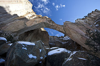
Cebolla Wilderness is a 61,600-acre (24,900 ha) Wilderness area located within the El Malpais National Conservation Area in New Mexico. The area was added to the National Wilderness Preservation System on December 31, 1987 by Public Law 100-225. The area is a bordered by the Acoma Pueblo to the east and the El Malpais National Monument and New Mexico Highway 117 to the west. Elevations range from 7,000 feet (2,100 m) to 8,200 feet (2,500 m). The sandstone canyons and mesas of this rimrock area include features such as La Ventana natural arch.

<span class="mw-page-title-main">Ojito Wilderness</span>

Ojito Wilderness is a designated Wilderness Area in Sandoval County, New Mexico, administered by the U. S. Bureau of Land Management. Established in 2005, the 11,823 acre primitive area protects a rugged and austere landscape north of Albuquerque, and is open to primitive camping, hiking, and horseback riding.

References

  1. 1 2 3 4 "Wilderness Connect". wilderness.net.
  2. 1 2 "West Malpais Wilderness Area | Bureau of Land Management".
  3. https://wilderness.net/visit-wilderness/?ID name=642#general
  4. "Programs: National Conservation Lands: Wilderness: New Mexico: West Malpais Wilderness | BUREAU OF LAND MANAGEMENT". Blm.gov. Retrieved 2017-06-11.
  5. "El Malpais National Monument (U.S. National Park Service)". www.nps.gov.
  6. "Programs: National Conservation Lands: Wilderness: New Mexico: Cebolla Wilderness | Bureau of Land Management".
  7. "Camping and Picnicking - El Morro National Monument (U.S. National Park Service)". www.nps.gov.