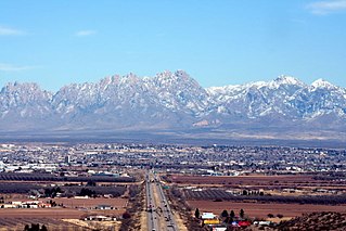
Las Cruces is the seat of Doña Ana County, New Mexico, United States. As of the 2010 census the population was 97,618, and in 2017 the estimated population was 101,712, making it the second largest city in the state, after Albuquerque. Las Cruces is the largest city in both Doña Ana County and southern New Mexico. The Las Cruces metropolitan area had an estimated population of 213,849 in 2017. It is the principal city of a metropolitan statistical area which encompasses all of Doña Ana County and is part of the larger El Paso–Las Cruces combined statistical area.
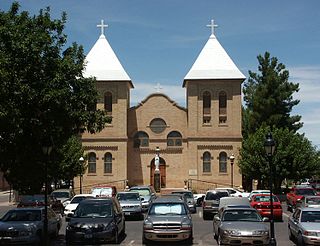
Mesilla is a town in Doña Ana County, New Mexico, United States. The population was 2,196 at the 2010 census. It is part of the Las Cruces Metropolitan Statistical Area.

Chapultepec, more commonly called the "Bosque de Chapultepec" in Mexico City, is one of the largest city parks in the Western Hemisphere, measuring in total just over 686 hectares. Centered on a rock formation called Chapultepec Hill, one of the park's main functions is an ecological space in Greater Mexico City. It is considered the first and most important of Mexico City's "lungs", with trees that replenish oxygen to the Valley of Mexico. The park area has been inhabited and considered a landmark since the Pre-Columbian era, when it became a retreat for Aztec rulers. In the colonial period, Chapultepec Castle was built here, eventually becoming the official residence of Mexican heads of state. It would remain so until 1940, when it was moved to another part of the park called Los Pinos.

Confederate Arizona, commonly referred to as Arizona Territory, and officially the Territory of Arizona, was a territory claimed by the Confederate States of America during the American Civil War, between 1861 and 1865. Delegates to secession conventions had voted in March 1861 to secede from the New Mexico Territory and the United States, and seek to join the Confederacy. It consisted of the portion of the New Mexico Territory south of the 34th parallel, including parts of the modern states of New Mexico and Arizona. Its capital was Mesilla along the southern border. The Confederate territory overlapped the Arizona Territory later established by the Union government in 1863.

The New Mexico Campaign was a military operation of the Trans-Mississippi Theater of the American Civil War from February to April 1862 in which Confederate Brigadier General Henry Hopkins Sibley invaded the northern New Mexico Territory in an attempt to gain control of the Southwest, including the gold fields of Colorado and the ports of California. Historians regard this campaign as the most ambitious Confederate attempt to establish control of the American West and to open an additional theater in the war. It was an important campaign in the war's Trans-Mississippi Theater, and one of the major events in the history of the New Mexico Territory in the American Civil War.
Fort Sumner was a military fort in New Mexico Territory charged with the internment of Navajo and Mescalero Apache populations from 1863 to 1868 at nearby Bosque Redondo.
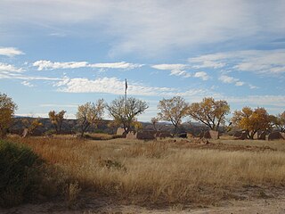
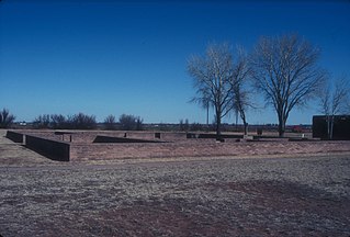
Fort Selden was a United States Army post, occupying the area in what is now Radium Springs, New Mexico. The site was long a campground along the El Camino Real de Tierra Adentro. It was the site of a Confederate Army camp in 1861. The U. S. Army established Fort Selden in 1865 for the purpose of protecting westward settlers from Native American raids, the post fell into disrepair after the American Civil War. It was ultimately abandoned in 1891, due in large part to the decision to expand Fort Bliss and the lack of any expenditures for repair of the facility.

The Rio Grande Nature Center State Park is a New Mexico State Park located adjacent to the Rio Grande in Albuquerque, New Mexico, USA. The Rio Grande Nature Center is a 38 acre urban wildlife preserve established in 1982. About two thirds of the grounds of the Park are set aside as habitat for wildlife. The remaining acreage contains a visitors center, two gardens, several wildlife viewing areas, an education building and a building housing the non-profit Wildlife Rescue, Inc. There are four constructed ponds which provide habitat for birds and other wildlife and which mimic wetland features of the historical flood plain of the Rio Grande.

Leasburg Dam State Park is a state park of New Mexico, United States, located on the Rio Grande. It provides opportunities for camping, hiking, picnicking, swimming, and wildlife viewing. Nearby is the historic Fort Seldon State Monument, and 15 miles (24 km) to the south is the city of Las Cruces.

The Mesilla Valley is a geographic feature of Southern New Mexico and far West Texas. It was formed by repeated heavy spring floods of the Rio Grande.
The Mesilla Valley AVA is an American Viticultural Area located primarily in the state of New Mexico with a small area in the state of Texas. Spanish explorer Don Juan de Oñate arrived in the area in 1598 and named a Native American village in the valley Trenquel de la Mesilla, from which the valley as a whole became known as Mesilla Valley. Although viticulture began in nearby El Paso as early as 1650, grapes were first planted in the Mesilla Valley only in the early twentieth century, near the town of Doña Ana. The climate in the Mesilla Valley is dry and hot.

The Rio Grande Trail is a proposed long distance trail along the Rio Grande in the U.S. state of New Mexico. The river extends over 1,800 total miles, some 700 miles (1,100 km) of which pass through the heart of New Mexico. It is the state's primary drainage feature and most valuable natural and cultural resource. The river and its bosque provide a wide variety of recreation, including hunting and fishing, birdwatching, river rafting, hiking, biking, and horseback riding. The river also flows through or beside numerous spectacular and geologically interesting landforms, the result of extensive volcanism and erosion within the Rio Grande Rift. Although some trail advocates would like to see the trail extended the full distance through New Mexico, from the Colorado border to the United States–Mexico border, the portion proposed for initial development extends 300 miles (480 km), from Bernalillo south to Las Cruces.

Union forces entered Tucson on May 20, 1862, with a force of 2,000 men without firing a shot.
Mesilla Valley Mall is a 602,150-square-foot (55,942 m2) shopping mall located in Las Cruces, New Mexico located on 77.4 acres (31.3 ha). It is managed by Spinoso Real Estate Group. Opened in 1981, the indoor shopping center has 85 stores.
The 1904 New Mexico A&M Aggies football team was an American football team that represented New Mexico College of Agriculture and Mechanical Arts during the 1904 college football season. In their fifth year under head coach John O. Miller, the Aggies compiled a 1–2–1 record and outscored opponents by a total of 42 to 33. The team played its home games on College Field, later renamed Miller Field in honor of coach Miller.
The 1914 New Mexico A&M Aggies football team was an American football team that represented New Mexico College of Agriculture and Mechanical Arts during the 1914 college football season. In their first year under head coach Clarence W. Russell, the Aggies compiled a 4–2–1 record and outscored all opponents by a total of 80 to 29.


