Organ Mountains-Desert Peaks National Monument

Last updated
Organ Mountains-Desert Peaks National Monument
Usa edcp relief location map.png
Red pog.svg
Location Doña Ana County, New Mexico, United States
Nearest city Las Cruces, NM
Coordinates 32°19′34″N106°33′18″W / 32.326°N 106.555°W / 32.326; -106.555 Coordinates: 32°19′34″N106°33′18″W / 32.326°N 106.555°W / 32.326; -106.555 [1]
Area 496,330 acres (200,860 ha)
Established May 21, 2014
Governing body Bureau of Land Management
Website Organ Mountains-Desert Peaks National Monument
Moonrise over Organ Mountains-Desert Peaks National Monument Organ Mountains-Desert Peaks National Monument (17717943249).jpg
Moonrise over Organ Mountains-Desert Peaks National Monument

The Organ Mountains-Desert Peaks National Monument is a United States National Monument in the state of New Mexico, managed by the Bureau of Land Management as part of the National Landscape Conservation System.

New Mexico State of the United States of America

New Mexico is a state in the Southwestern region of the United States of America; its capital and cultural center is Santa Fe, which was founded in 1610 as capital of Nuevo México, while its largest city is Albuquerque with its accompanying metropolitan area. It is one of the Mountain States and shares the Four Corners region with Utah, Colorado, and Arizona; its other neighboring states are Oklahoma to the northeast, Texas to the east-southeast, and the Mexican states of Chihuahua to the south and Sonora to the southwest. With a population around two million, New Mexico is the 36th state by population. With a total area of 121,592 sq mi (314,920 km2), it is the fifth-largest and sixth-least densely populated of the 50 states. Due to their geographic locations, northern and eastern New Mexico exhibit a colder, alpine climate, while western and southern New Mexico exhibit a warmer, arid climate.

Bureau of Land Management agency within the United States Department of the Interior

The Bureau of Land Management (BLM) is an agency within the United States Department of the Interior that administers more than 247.3 million acres (1,001,000 km2) of public lands in the United States which constitutes one eighth of the landmass of the country. President Harry S. Truman created the BLM in 1946 by combining two existing agencies: the General Land Office and the Grazing Service. The agency manages the federal government's nearly 700 million acres (2,800,000 km2) of subsurface mineral estate located beneath federal, state and private lands severed from their surface rights by the Homestead Act of 1862. Most BLM public lands are located in these 12 western states: Alaska, Arizona, California, Colorado, Idaho, Montana, Nevada, New Mexico, Oregon, Utah, Washington and Wyoming.

Contents

Description

Organ Mountains Organ Mountains WSA (9469542743).jpg
Organ Mountains

The 496,330-acre (200,860 ha) monument is located in the Mesilla Valley in southern New Mexico, surrounding the city of Las Cruces in Doña Ana County. The protected area includes several mountain ranges of the Chihuahuan Desert. The five identified as being within the national monument are the Robledo Mountains, Sierra de las Uvas, Doña Ana Mountains, Organ Mountains and Potrillo Mountains. [2] The Prehistoric Trackways National Monument is nearby. [2] The monument protects a large variety of geological, paleontological and archaeological resources. [2]

Mesilla Valley valley in Texas, United States of America

The Mesilla Valley is a geographic feature of Southern New Mexico and far West Texas. It was formed by repeated heavy spring floods of the Rio Grande.

Las Cruces, New Mexico City in New Mexico, United States

Las Cruces is the seat of Doña Ana County, New Mexico, United States. As of the 2010 census the population was 97,618, and in 2017 the estimated population was 101,712, making it the second largest city in the state, after Albuquerque. Las Cruces is the largest city in both Doña Ana County and southern New Mexico. The Las Cruces metropolitan area had an estimated population of 213,849 in 2017. It is the principal city of a metropolitan statistical area which encompasses all of Doña Ana County and is part of the larger El Paso–Las Cruces combined statistical area.

Doña Ana County, New Mexico County in the United States

Doña Ana County is a county located in the southern part of the State of New Mexico of the United States. As of the 2010 U.S. Census, its population was 209,233, which makes it the second-most populated county in New Mexico. Its county seat is Las Cruces, the second-most populous municipality in New Mexico.

President Barack Obama designated the monument on May 21, 2014. [3] Half of the monument is designated wilderness and closed to development or motorized use. [4]

Barack Obama 44th president of the United States

Barack Hussein Obama II is an American attorney and politician who served as the 44th president of the United States from 2009 to 2017. A member of the Democratic Party, he was the first African American to be elected to the presidency. He previously served as a U.S. senator from Illinois from 2005 to 2008.

National Wilderness Preservation System

The National Wilderness Preservation System (NWPS) of the United States protects federally managed wilderness areas designated for preservation in their natural condition. Activity on formally designated wilderness areas is coordinated by the National Wilderness Preservation System. Wilderness areas are managed by four federal land management agencies: the National Park Service, the U.S. Forest Service, the U.S. Fish and Wildlife Service, and the Bureau of Land Management. The term "wilderness" is defined as "an area where the earth and community of life are untrammeled by man, where man himself is a visitor who does not remain" and "an area of undeveloped Federal land retaining its primeval character and influence, without permanent improvements or human habitation, which is protected and managed so as to preserve its natural conditions." As of 2016, there are 765 designated wilderness areas, totaling 109,129,657 acres (44,163,205 ha), or about 4.5% of the area of the United States.

Protected areas

Organ Mountains-Desert Peaks protects many archaeological and cultural sites of interest. [5] Before the Gadsden Purchase of 1853, this land included the border between Mexico and the United States. [6] The Aden Lava Flow Wilderness Study Area is here [2] and there are 243 known archaeological sites within the monument, [4] including some of the earliest Native American settlements and petroglyphs known from three different tribes. [4] The land also includes Shelter Cave and Conkling Cavern. [6] Fossils of ground sloths have been found in the area. [2]

Gadsden Purchase

The Gadsden Purchase, known in Mexico as Spanish: Venta de La Mesilla, is a 29,670-square-mile (76,800 km2) region of present-day southern Arizona and southwestern New Mexico that the United States acquired from Mexico by the Treaty of Mesilla, which took effect on June 8, 1854. The purchase included lands south of the Gila River and west of the Rio Grande which the U.S. needed to build a transcontinental railroad along a deep southern route, which the Southern Pacific Railroad later completed in 1881–1883. The purchase also aimed to resolve other border issues.

Petroglyph pictogram and logogram images carved on a rock surface

Petroglyphs are images created by removing part of a rock surface by incising, picking, carving, or abrading, as a form of rock art. Outside North America, scholars often use terms such as "carving", "engraving", or other descriptions of the technique to refer to such images. Petroglyphs are found worldwide, and are often associated with prehistoric peoples. The word comes from the Greek prefix petro-, from πέτρα petra meaning "stone", and γλύφω glýphō meaning "to carve", and was originally coined in French as pétroglyphe.

More recently the land was used by William H. Bonney, better known as the outlaw Billy the Kid, and Geronimo, a leader during the Apache Wars, both of whom lived in various parts of New Mexico in the 19th century. [4] It is said that Billy the Kid visited "Outlaw Rock", and there is a cave known as "Geronimo's Rock". [6] The monument also includes 22 miles (35 km) of the historic Butterfield Stagecoach Trail. [7]

Billy the Kid American cattle rustler, gambler, horse thief, outlaw, cowboy and ranch hand

Billy the Kid was an American Old West outlaw and gunfighter who killed eight men before he was shot and killed at age 21. He took part in New Mexico's Lincoln County War, during which he allegedly committed three murders.

Geronimo leader of the Bedonkohe Apache

Geronimo was a prominent leader and medicine man from the Bedonkohe band of the Apache tribe. From 1850 to 1886 Geronimo joined with members of three other Chiricahua Apache bands—the Tchihende, the Tsokanende and the Nednhi—to carry out numerous raids as well as resistance to US and Mexican military campaigns in the northern Mexico states of Chihuahua and Sonora, and in the southwestern American territories of New Mexico and Arizona. Geronimo's raids and related combat actions were a part of the prolonged period of the Apache–United States conflict, which started with American settlement in Apache lands following the end of the war with Mexico in 1848.

Apache Wars armed conflicts between indigenous peoples and white people in southwestern USA between 1849 and circa 1924

The Apache Wars were a series of armed conflicts between the United States Army and various Apache nations fought in the southwest between 1849 and 1886, though minor hostilities continued until as late as 1924. The United States inherited conflicts between American invaders and Apache groups when Mexico ceded territory after the Mexican–American War in 1846. These conflicts continued as new United States citizens came into traditional Apache lands to raise livestock, crops and to mine minerals.

The monument includes sites where World War II bombers practiced their targeting, as well as Kilbourne Hole in the Potrillo volcanic field, where American astronauts trained for lunar missions in the 1960s. [7]

World War II 1939–1945 global war

World War II, also known as the Second World War, was a global war that lasted from 1939 to 1945. The vast majority of the world's countries—including all the great powers—eventually formed two opposing military alliances: the Allies and the Axis. A state of total war emerged, directly involving more than 100 million people from over 30 countries. The major participants threw their entire economic, industrial, and scientific capabilities behind the war effort, blurring the distinction between civilian and military resources. World War II was the deadliest conflict in human history, marked by 50 to 85 million fatalities, most of whom were civilians in the Soviet Union and China. It included massacres, the genocide of the Holocaust, strategic bombing, premeditated death from starvation and disease, and the only use of nuclear weapons in war.

Kilbourne Hole

Kilbourne Hole is a maar volcanic crater, located 30 miles (48 km) west of the Franklin Mountains of El Paso, Texas, in the Potrillo volcanic field of Doña Ana County, New Mexico. Another maar, Hunt's Hole, lies just two miles south of Kilbourne Hole. These holes are rare examples of volcanic action without a mountainous rim.

Potrillo volcanic field mountain in United States of America

The Potrillo volcanic field is a monogenetic volcanic field located on the Rio Grande Rift, in a portion of its rift valley, in southern New Mexico, United States and northern Chihuahua, Mexico. The volcanic field lies 22 miles (35 km) southwest of Las Cruces, and occupies more than 1,000 square kilometers near the U.S. border with Mexico.

Campaign for establishment

The area was given national monument status following a campaign by conservation advocates that lasted several years. Several bills were introduced in Congress to protect the area through legislation, but they were blocked by House Republicans. In contrast with some previous monument designations, communities and governments of Doña Ana County were supportive of the application for designation. A poll found that 60 percent of the local voters favored establishing this land as a 500,000-acre national monument. [8]

Related Research Articles

San Gorgonio Wilderness

The San Gorgonio Wilderness is located in the eastern San Bernardino Mountains, in San Bernardino County and into northern Riverside County, Southern California.

Organ Mountains

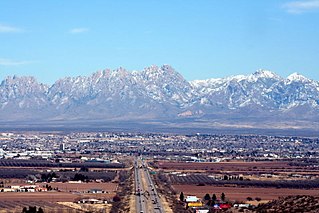
The Organ Mountains are a rugged mountain range in southern New Mexico in the Southwestern United States. Organ Mountains-Desert Peaks National Monument was declared a national monument on May 21, 2014. They lie 10 miles (16 km) east of the city of Las Cruces, in Doña Ana County.

Sonoran Desert National Monument national monument in Arizona

Sonoran Desert National Monument is south of Goodyear and Buckeye and east of Gila Bend, Arizona. Created by Presidential proclamation on January 17, 2001, the 496,400 acres (200,886 ha) monument is managed by the U.S. Bureau of Land Management as part of the National Landscape Conservation System. The BLM already managed the lands, however under monument status, the level of protection and preservation of resources is enhanced. Sonoran Desert National Monument protects but a small portion of the Sonoran Desert, which is 120,000 square miles (311,000 km2), and extends well into California and the country of Mexico. The North Maricopa Mountains, South Maricopa Mountains and the Table Top Wildernesses protect the richest regions of desert habitat from development.

Otero Mesa

Otero Mesa is a 1.2 million acre (4,900 km²) area in northern Chihuahuan Desert region of southern New Mexico. Between 1954 and 1965 the U.S. Army expanded its McGregor Range facilities at Fort Bliss onto Otero Mesa by purchasing ranches. In 2005, the Bureau of Land Management approved the area for exploratory drilling for oil and gas, but that approval is currently being litigated by the state of New Mexico and environmental groups who want the mesa to be recognized as protected wilderness.

East Potrillo Mountains

The East Potrillo Mountains are a mountain range in south central Doña Ana County, New Mexico. They are located approximately 25 miles (40 km) west of El Paso, Texas, 30 miles (50 km) southwest of Las Cruces, New Mexico, and 30 miles east of Columbus, New Mexico. The southern tip of the range is less than 5 miles (8 km) from the Mexican border. The mountains and most of the surrounding acreage are located on land owned by the Bureau of Land Management. Access to the general vicinity is through New Mexico State Road 9, and several unpaved county roads.

West Potrillo Mountains

The West Potrillo Mountains are a mountain range in south central Doña Ana County, New Mexico, United States. They are located approximately 40 miles (65 km) northwest of El Paso, Texas, 25 miles (40 km) southwest of Las Cruces, New Mexico, and 35 miles (55 km) southeast of Deming, New Mexico Most of the mountains are located on land managed by the Bureau of Land Management as part of the Organ Mountains-Desert Peaks National Monument. Access to the vicinity is through Doña Ana County Road B-4 South from NM 549, which may be accessed from Interstate 10 Exit 116.

Soda Mountain Wilderness

The Soda Mountain Wilderness is a protected wilderness area inside the Cascade–Siskiyou National Monument located in the U.S. state of Oregon adjacent to the California state border. The wilderness area was created by the Omnibus Public Land Management Act of 2009, which was signed into law by President Barack Obama on March 30, 2009. The wilderness encompasses many mountains, including Boccard Point

Prehistoric Trackways National Monument

Prehistoric Trackways National Monument is a national monument in the Robledo Mountains of Doña Ana County, New Mexico, United States, near the city of Las Cruces. The monument's Paleozoic Era fossils are on 5,255 acres (2,127 ha) of land administered by the Bureau of Land Management. It became the 100th active U.S. national monument when it was designated on March 30, 2009.

Santa Rosa Wilderness

The Santa Rosa Wilderness is a 72,259-acre (292.42 km2) wilderness area in Southern California, in the Santa Rosa Mountains of Riverside and San Diego counties, California. It is in the Colorado Desert section of the Sonoran Desert, above the Coachella Valley and Lower Colorado River Valley regions in a Peninsular Range, between La Quinta to the north and Anza Borrego Desert State Park to the south. The United States Congress established the wilderness in 1984 with the passage of the California Wilderness Act, managed by the both US Forest Service and the Bureau of Land Management. In 2009, the Omnibus Public Land Management Act was signed into law which added more than 2,000 acres (8.1 km2). Most of the Santa Rosa Wilderness is within the Santa Rosa and San Jacinto Mountains National Monument.

Rio Grande del Norte National Monument

The Rio Grande del Norte National Monument is an approximately 242,555-acre (98,159 ha) area of public lands in Taos County, New Mexico, proclaimed as a national monument on March 25, 2013 by President Barack Obama under the provisions of the Antiquities Act. It consists of the Rio Grande Gorge and surrounding lands, managed by the Bureau of Land Management (BLM).

San Juan Islands National Monument national monument in Washington, United States

San Juan Islands National Monument is a U.S. National Monument located in the Salish Sea in the state of Washington. The monument protects archaeological sites of the Coast Salish peoples, lighthouses and relics of early European American settlers in the Pacific Northwest, and biodiversity of the island life in the region. The monument was created from existing federal land by President Barack Obama on March 25, 2013 under the Antiquities Act.

Basin and Range National Monument in Lincoln and Nye counties in southeastern Nevada, within the Basin and Range Province

Basin and Range National Monument is a national monument of the United States spanning approximately 704,000 acres of remote, undeveloped mountains and valleys in Lincoln and Nye counties in southeastern Nevada. It is described as "one of the emptiest spaces in a state famous for its emptiness."

Castle Mountains National Monument protected area in California

Castle Mountains National Monument is a U.S. National Monument located in the eastern Mojave Desert and northeastern San Bernardino County, in the state of California.

Mojave Trails National Monument

Mojave Trails National Monument is a large U.S. National Monument located in the state of California between Interstates 15 and 40. It partially surrounds the Mojave National Preserve. It was designated by President Obama on February 12, 2016 along with Castle Mountains National Monument and Sand to Snow National Monument. It is under the control of the Bureau of Land Management.

Sand to Snow National Monument protected area in California

Sand to Snow National Monument is a U.S. National Monument located in San Bernardino County and into northern Riverside County, Southern California.

Bears Ears National Monument Protected area in Utah

Bears Ears National Monument is a United States national monument located in San Juan County in southeastern Utah, established by President Barack Obama by presidential proclamation on December 28, 2016. The monument's original size was 1,351,849 acres, which was controversially reduced 85% by President Donald Trump on December 4, 2017. The monument protects the public land surrounding the Bears Ears—a pair of buttes—and the Indian Creek corridor rock climbing area. The Native American names for the buttes have the same meaning in each of the languages represented in the region. The names are listed in the presidential proclamation as "Hoon’Naqvut, Shash Jáa [sic], Kwiyagatu Nukavachi, Ansh An Lashokdiwe"—all four mean "Bears Ears".

Gold Butte National Monument protected area in Nevada

Gold Butte National Monument is a United States national monument located in Clark County, Nevada, northeast of Las Vegas and south of Mesquite and Bunkerville. The monument protects nearly 300,000 acres of desert landscapes featuring a wide array of natural and cultural resources, including rock art, sandstone towers, and important wildlife habitat for species including the Mojave Desert tortoise, bighorn sheep, and mountain lion. The area also protects historic ranching and mining sites such as the ghost town of Gold Butte, although little but mine openings, cement foundations, and a few pieces of rusting equipment remains. The monument is managed by the Bureau of Land Management.

West Malpais Wilderness

West Malpais Wilderness is a designated Wilderness Area managed by the U. S. Bureau of Land Management [BLM] located in Cibola County, New Mexico. Established in 1987, the West Malpais Wilderness is located in the El Malpais National Conservation Area, a BLM-managed area that stretches along the western border of the Acoma Indian Reservation SW of Albuquerque. One of two Wilderness Areas in the Conservation Area, the 35,940 acre West Malpais area is contiguous with El Malpais National Monument, a National Park Service unit, and contains a section of the Continental Divide National Scenic Trail.

References

  1. "Organ Mountains". Geographic Names Information System . United States Geological Survey . Retrieved May 22, 2014.
  2. 1 2 3 4 5 Presidential Proclamation -- Organ Mountains-Desert Peaks National Monument, Barack Obama, The White House, 21 May 2014
  3. "Obama declares the Organ Mountains-Desert Peaks region of N.M. a national monument". Published May 21, 2014. Washington Post. Retrieved 22 May 2014.
  4. 1 2 3 4 New National Monument Created in New Mexico, National Geographic, retrieved 9 June 2014
  5. "Organ Mountains – Desert Peaks". New Mexico Wilderness Alliance. Retrieved 22 May 2014.
  6. 1 2 3 Organ Mountains-Desert Peaks National Monument Fact Sheet, organmountains.org, retrieved 9 June 2014
  7. 1 2 Organ Mountains-Desert Peaks National Monument to be Protected, nwwild.org, retrieved 9 June 2014
  8. Poll finds strong support for larger Organ Mountains proposal, Phil Taylor, Environment and Energy Publishing, 23 January 2014