
Katmai National Park and Preserve is an American national park and preserve in southwest Alaska, notable for the Valley of Ten Thousand Smokes and for its brown bears. The park and preserve encompass 4,093,077 acres, which is between the sizes of Connecticut and New Jersey. Most of the national park is a designated wilderness area. The park is named after Mount Katmai, its centerpiece stratovolcano. The park is located on the Alaska Peninsula, across from Kodiak Island, with headquarters in nearby King Salmon, about 290 miles (470 km) southwest of Anchorage. The area was first designated a national monument in 1918 to protect the area around the major 1912 volcanic eruption of Novarupta, which formed the Valley of Ten Thousand Smokes, a 40-square-mile (100 km2), 100-to-700-foot-deep pyroclastic flow. The park includes as many as 18 individual volcanoes, seven of which have been active since 1900.

Kiska is one of the Rat Islands, a group of the Aleutian Islands of Alaska. It is about 22 miles (35 km) long and varies in width from 1.5 to 6 miles. It is part of Aleutian Islands Wilderness and as such, special permission is required to visit it. The island has no permanent population.

The Alaska Peninsula National Wildlife Refuge is a United States National Wildlife Refuge in southwestern Alaska whose use is regulated as an ecological-protection measure. It stretches along the southern coast of the Alaska Peninsula, between the Becharof National Wildlife Refuge on its east and the end of the peninsula at False Pass in the west. In between, however, it is broken into sections by lands of the Aniakchak National Monument and Izembek National Wildlife Refuge. The refuge is administered from offices in King Salmon, Alaska and was established to conserve Alaska Peninsula brown bears, caribou, moose, marine mammals, shorebirds, other migratory birds and fish, and to comply with treaty obligations.

Aniakchak National Monument and Preserve is a U.S. National Monument and National Preserve, consisting of the region around the Aniakchak volcano on the Aleutian Range of south-western Alaska. It has erupted at least 40 times over the last 10,000 years. The 601,294-acre (243,335 ha) monument is one of the least-visited places in the National Park System due to its remote location and difficult weather. The area was proclaimed a National Monument on December 1, 1978, and established as a National Monument and Preserve on December 2, 1980. The National Monument encompasses 137,176 acres (55,513 ha) and the preserve 464,118 acres (187,822 ha). Visitation to Aniakchak is the lowest of all areas of the U.S. National Park System, according to the NPS, with only 100 documented recreational visits in 2017. Most visitors fly into Surprise Lake inside Aniakchak Crater, but the frequent fog and other adverse weather conditions make landing in the lake difficult. It is also possible to fly into the nearby village of Port Heiden and proceed overland to the Aniakchak Crater.

Glacier Bay National Park and Preserve is an American national park located in Southeast Alaska west of Juneau. President Calvin Coolidge proclaimed the area around Glacier Bay a national monument under the Antiquities Act on February 26, 1925. Subsequent to an expansion of the monument by President Jimmy Carter in 1978, the Alaska National Interest Lands Conservation Act (ANILCA) enlarged the national monument by 523,000 acres on December 2, 1980, and created Glacier Bay National Park and Preserve. The national preserve encompasses 58,406 acres of public land to the immediate northwest of the park, protecting a portion of the Alsek River with its fish and wildlife habitats, while allowing sport hunting.

The Alaska National Interest Lands Conservation Act (ANILCA) is a United States federal law signed by President Jimmy Carter on December 2, 1980. ANILCA provided varying degrees of special protection to over 157,000,000 acres (64,000,000 ha) of land, including national parks, national wildlife refuges, national monuments, wild and scenic rivers, recreational areas, national forests, and conservation areas. It was, and remains to date, the single largest expansion of protected lands in history and more than doubled the size of the National Park System.

Admiralty Island is an island in the Alexander Archipelago in Southeast Alaska, at 57°44′N134°20′W. It is 145 km (90 mi) long and 56 km (35 mi) wide with an area of 4,264.1 km2 (1,646.4 sq mi), making it the seventh-largest island in the United States and the 132nd largest island in the world. It is one of the ABC islands in Alaska. The island is nearly cut in two by the Seymour Canal; to its east is the long, narrow Glass Peninsula. Most of Admiralty Island—955,747 acres (3,868 km2)—is protected as the Admiralty Island National Monument administered by the Tongass National Forest. The Kootznoowoo Wilderness encompasses vast stands of old-growth temperate rainforest. These forests provide some of the best habitat available to species such as brown bears, bald eagles, and Sitka black-tailed deer.

Atka Island is the largest island in the Andreanof Islands of the Aleutian Islands of Alaska. The island is 50 miles (80 km) east of Adak Island. It is 65 miles (105 km) long and 2–20 miles (3–30 km) wide with a land area of 404.6 square miles (1,048 km2), making it the 22nd largest island in the United States. The northeast of Atka Island contains the Korovin volcano which reaches a peak of 5,030 feet (1,533 m). Oglodak Island is located 3.4 miles off Cape Kigun, Atka's westernmost point.
Adak Island or Father Island is an island near the western extent of the Andreanof Islands group of the Aleutian Islands in Alaska. Alaska's southernmost city, Adak, is located on the island. The island has a land area of 274.59 square miles (711.18 km2), measuring 33.9 miles (54.5 km) long and 22 miles (35 km) wide, making it the 25th largest island in the United States.
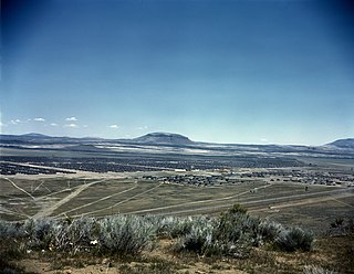
The Tule Lake National Monument in Modoc and Siskiyou counties in California, consists primarily of the site of the Tule Lake War Relocation Center, one of ten concentration camps constructed in 1942 by the United States government to incarcerate Japanese Americans forcibly removed from their homes on the West Coast. They totaled nearly 120,000 people, more than two-thirds of whom were United States citizens. Among the inmates, the notation "鶴嶺湖" was sometimes applied.
Buldir Island is a small island in the western Aleutian Islands of the U.S. state of Alaska. It is 4.3 miles (6.9 km) long and 2.5 miles (4.0 km) wide with an area of 7.4482 square miles (19.291 km2). Buldir is farther from the nearest land than any other Aleutian Island. Its nearest neighbors are Kiska in the Rat Island group, 68 miles (109 km) to the east, and Shemya in the Near Island group, 64 miles (103 km) to the west. Buldir Island is uninhabited. It is part of the Alaska Maritime National Wildlife Refuge. It has been designated a Research Natural Area.

Misty Fjords National Monument is a national monument and wilderness area administered by the U.S. Forest Service as part of the Tongass National Forest. Misty Fiords is about 40 miles (64 km) east of Ketchikan, Alaska, along the Inside Passage coast in extreme southeastern Alaska, comprising 2,294,343 acres (928,488 ha) of Tongass National Forest in Alaska's Panhandle. All but 151,832 acres (61,444 ha) are designated as wilderness.
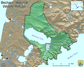
Becharof National Wildlife Refuge is a National Wildlife Refuge in the Aleutian Range of the Alaska Peninsula of southwestern Alaska. It is adjacent to Katmai National Park and Preserve. This national wildlife refuge, which covers an area of 1,200,000 acres (4,900 km2), was established in 1980 to conserve major brown bears, salmon, migratory birds, caribou, marine birds, and mammals and to comply with treaty obligations. It lies primarily in the east-central part of Lake and Peninsula Borough, but extends eastward into the mainland portion of Kodiak Island Borough. The refuge is administered from offices in King Salmon.

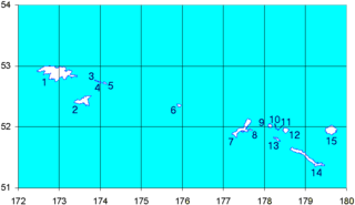
The Aleutian Islands —also called the Aleut Islands, Aleutic Islands, or, before 1867, the Catherine Archipelago—are a chain of 14 main, larger volcanic islands and 55 smaller ones. Most of the Aleutian Islands belong to the U.S. state of Alaska, with the archipelago encompassing the Aleutians West Census Area and the Aleutians East Borough. The Commander Islands, located further to the west, belong to the Russian federal subject of Kamchatka Krai, of the Russian Far East. The islands form part of the Aleutian Arc of the Northern Pacific Ocean, and occupy a land area of 6,821 sq mi (17,666 km2) that extends westward roughly 1,200 mi (1,900 km) from the Alaskan Peninsula mainland, in the direction of the Kamchatka Peninsula; the archipelago acts as a border between the Bering Sea to the north and the Pacific Ocean to the south. Crossing longitude 180°, at which point east and west longitude end, the archipelago contains both the westernmost and easternmost parts of the United States, by longitude. The westernmost U.S. island, in real terms, however, is Attu Island, west of which runs the International Date Line. While nearly all of the archipelago is part of Alaska at the extreme western end, the small, geologically-related Commander Islands belong to Russia.

The Japanese occupation of Attu was the result of an invasion of the Aleutian Islands in Alaska during World War II. Imperial Japanese Army troops landed on 7 June 1942, the day after the invasion of nearby Kiska. Along with the Kiska landing, it was the first time that the continental United States was invaded and occupied by a foreign power since the War of 1812, and was the second of the only two invasions of the United States during World War II. The occupation ended with the Allied victory in the Battle of Attu on 30 May 1943.

The Atka B-24D Liberator is a derelict bomber on Atka Island in the Aleutian Islands of Alaska. The Consolidated B-24D Liberator was deliberately crash-landed on the island on 9 December 1942, and is one of only eight surviving D-model Liberators. The aircraft, serial no. 40-2367, was built in 1941, and was serving on weather reconnaissance duty when it was prevented from landing at any nearby airfields due to poor weather conditions. The only injury resulting from the crash was a fractured collarbone sustained by Brigadier General William E. Lynd.
The Aleutian Islands World War II National Monument is a U.S. national monument in the Aleutian Islands of Alaska. It is located on three islands in the Alaska Maritime National Wildlife Refuge. It was designated as part of World War II Valor in the Pacific National Monument by an executive order of George W. Bush on December 5, 2008, with sites in Alaska, California, and Hawaii. The John D. Dingell, Jr. Conservation, Management, and Recreation Act, signed into law March 12, 2019, separated the national monument into separate units in each state. It is managed by the United States Fish and Wildlife Service.

The John D. Dingell Jr. Conservation, Management, and Recreation Act of 2019 is an omnibus lands act that protected public lands and modified management provisions. The bill designated more than 1,300,000 acres (5,300 km2) of wilderness area, expanded several national parks and other areas of the National Park System, and established four new national monuments while redesignating others. Other provisions included making the Land and Water Conservation Fund permanent, protecting a number of rivers and historic sites, and withdrawing land near Yellowstone National Park and North Cascades National Park from mining.

Pearl Harbor National Memorial is a unit of the National Park System of the United States on the island of Oahu, Hawaii. The John D. Dingell, Jr. Conservation, Management, and Recreation Act removed the site from the World War II Valor in the Pacific National Monument on March 12, 2019, and made it a separate national memorial. It has an area of 21.3 acres (0.086 km2).


