The following 18 or more state parks , monuments, and recreation areas are managed by the Division of State Parks within the Hawai'i Department of Land and Natural Resources: [1]
The following 18 or more state parks , monuments, and recreation areas are managed by the Division of State Parks within the Hawai'i Department of Land and Natural Resources: [1]
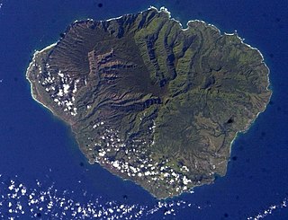
Kauaʻi, anglicized as Kauai, is geologically the second-oldest of the main Hawaiian Islands. With an area of 562.3 square miles, it is the fourth-largest of the islands and the 21st-largest island in the United States. Nicknamed the Garden Isle, Kauaʻi lies 73 miles across the Kauaʻi Channel, northwest of Oʻahu. It is the site of Waimea Canyon State Park and the Na Pali Coast State Park.

Hawaii is the largest island in the United States, located in the state of Hawaii. It is the southeasternmost of the Hawaiian Islands, a chain of volcanic islands in the North Pacific Ocean. With an area of 4,028 square miles (10,430 km2), it has 63% of the Hawaiian archipelago's combined landmass. However, it has only 13% of the archipelago's population. The island of Hawaiʻi is the third largest island in Polynesia, behind the north and south islands of New Zealand.

Hilo is the largest settlement in Hawaii County, Hawaii, United States, which encompasses the Island of Hawaii, and a census-designated place (CDP). The population was 44,186 according to the 2020 census. It is the fourth-largest settlement in the state of Hawaii and largest settlement in the state outside of Oahu.

Hualālai is an active volcano on the island of Hawaiʻi in the Hawaiian Islands. It is the westernmost, third-youngest and the third-most active of the five volcanoes that form the island of Hawaiʻi, following Kīlauea and the much larger Mauna Loa. Its peak stands 8,271 feet (2,521 m) above sea level. Hualālai is estimated to have risen above sea level about 300,000 years ago. Despite maintaining a very low level of activity since its last eruption in 1801, and being unusually inactive for the last 2,000 years, Hualālai is still considered active, and is expected to erupt again sometime in the next 100 years. The relative unpreparedness of the residents in the area caused by the lull in activity would worsen an eruption's consequences.
The following is an alphabetical list of articles related to the U.S. state of Hawaii:
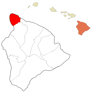
Kohala is the name of the northwest peninsula of the island of Hawaiʻi in the Hawaiian Archipelago. In ancient Hawaii it was often ruled by an independent High Chief called the Aliʻi Nui. In modern times it is divided into two districts of Hawaii County: North Kohala and South Kohala. Locals commonly use the name Kohala to refer to the census-designated places of Halaʻula, Hāwī, and Kapaʻau collectively. The dry western shore is commonly known as the Kohala Coast, which has golf courses and seaside resorts.

Puʻuhonua o Hōnaunau National Historical Park is a United States National Historical Park located on the west coast of the island of Hawaiʻi in the U.S. state of Hawaii. The historical park preserves the site where, up until the early 19th century, Hawaiians who broke a kapu could avoid certain death by fleeing to this place of refuge or puʻuhonua. The offender would be absolved by a priest and freed to leave. Defeated warriors and non-combatants could also find refuge here during times of battle. The grounds just outside the Great Wall that encloses the puʻuhonua were home to several generations of powerful chiefs.

Route 200, known locally as Saddle Road, traverses the width of the Island of Hawaiʻi, from downtown Hilo to its junction with Hawaii Route 190 near Waimea. The road was once considered one of the most dangerous paved roads in the state, with many one-lane bridges and areas of marginally maintained pavement. Most of the road has now been repaved, and major parts have new re-alignments to modern standards. The highway is mostly one-lane in each direction, but there are two lanes on the uphill portions. The highway reaches a maximum elevation of 6,632 feet (2,021 m) and is subject to fog and low visibility. Many rental car companies used to prohibit use of their cars on Saddle Road, but now allow use of the road. The highway experiences heavy use as it provides the shortest driving route from Hilo to Kailua-Kona and access to the slopes of Mauna Loa and the Mauna Kea Observatories.

A heiau is a Hawaiian temple. Made in different architectural styles depending upon their purpose and location, they range from simple earth terraces, to elaborately constructed stone platforms. There are heiau to treat the sick, offer first fruits, offer first catch, start rain, stop rain, increase the population, ensure the health of the nation, achieve success in distant voyaging, reach peace, and achieve success in war (luakini).

Kōkeʻe State Park is located in northwestern Kauaʻi in the Hawaiian Islands. It includes the Kōkeʻe Museum at the 15 mi (24 km) marker on State Road 550, which focuses on the weather, vegetation, and bird life; a lodge which serves food and sells gifts; cabins for rent; and hiking trails. The park is just north of Waimea Canyon State Park at 22°7′49″N159°39′32″W and includes 4,345 acres (17.58 km2) of mountainous terrain.

Hāpuna Beach State Recreation Area is a large park and sandy beach on the Big Island of Hawaii. The Hapuna Beach Prince Hotel is also located adjacent to the beach. Hāpuna is popular with residents and visitors.
The ʻAkoni Pule Highway, designated as Hawaiʻi Route 270, is a state highway in Hawaii County, Hawaii, United States, that is the main road along the North Kohala Coast on the Island of Hawaiʻi from Kawaihae to ʻUpolu Point and then on to Pololū Valley Lookout. The entire route is 27.0 miles (43.5 km) long.
The Hawaiʻi Belt Road is a modern name for the Māmalahoa Highway and consists of Hawaiʻi state Routes 11, 19, and 190 that encircle the Island of Hawaiʻi. The southern section, between Hilo and Kailua-Kona is numbered as Route 11. The section between Hilo and Waimea is Route 19. Between Waimea and Kailua-Kona, the road is split in two: the original "mauka" route and a "makai" Route 19, completed in 1975, which serves as access to the Kona and Kohala Coast resorts. In the Hawaiian language, mauka means "towards the mountain" and makai means "towards the sea". These terms are commonly used in travel directions.
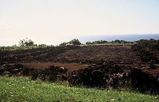
Puʻu o Mahuka Heiau State Historic Site on the North Shore of Oʻahu is the largest heiau on the island, covering 2 acres (8,100 m2) on a hilltop overlooking Waimea Bay and Waimea Valley. From its commanding heights, sentries could once monitor much of the northern shoreline of Oʻahu, and even spot signal fires from the Wailua Complex of Heiaus on Kauaʻi, with which it had ties. It was designated a National Historic Landmark in 1962, when it became the center of a 4-acre (16,000 m2) state park. It was added to the National Register of Historic Places in 1966.

Halekiʻi-Pihana Heiau State Monument is a 10-acre (4.0 ha) park containing two important luakini heiau on a high ridge near the mouth of ʻIao Stream in Wailuku, Maui. Both Halekiʻi and Pihana were associated with important Hawaiian chiefs, have been closely studied by archaeologists, and overlook the fertile Nā Wai ʻEhā region irrigated by the Wailuku, Waikapu, Waiheʻe and Waiehu streams. The heiau complex was added to the National Register of Historic Places on 25 November 1985.

Ahu A ʻUmi Heiau means "shrine at the temple of ʻUmi" in the Hawaiian Language. It is also spelled "ahu-a-Umi", or known as Ahua A ʻUmi Heiau, which would mean "mound of ʻUmi". It was built for ʻUmi-a-Liloa, often called ʻUmi, who ruled the island of Hawaiʻi early in the 16th century. He moved the seat of government here from the Waipiʻo Valley. The seat of power generally remained in the Kona District until the plantation days hundreds of years later. Ahu A ʻUmi Heiau was also the place where the great chief Keawenuiaʻumi hid to escape death from a strong aliʻi, Kalepuni, who attempted to take over Keawe's rule. The site was an enclosure surrounded by a number of stone cairns, up to four meters high and seven meters in diameter.

Kaunaʻoa Bay has one of the few white sand beaches of the Kohala Coast, the western side of the island of Hawaiʻi. A historic hotel, the Mauna Kea Beach Hotel, is located on beautiful Kauna'oa.

The Mauna Kea Ice Age Natural Area Reserve is a Hawaii state natural reserve that includes the Mauna Kea Adz Quarry, on the southern slope of Mauna Kea on the island of the Hawaiʻi.
Roberta Kuʻulei Keakealani is an educator, cultural practitioner, poet, storyteller, and activist from a paniolo family from Puʻuanahulu, North Kona, Hawaii. She was a director of Ahahui O Puʻu Waʻawaʻa, a member of the Puʻu Waʻawaʻa Advisory Council in consultation with the Department of Land and Natural Resources, and the president of Hui ʻOhana Mai Puʻu Anahulu A Me Puʻu Waʻawaʻa. Keakealani is the cultural and educational director of Hui Aloha Kīholo and the Director of Ka Pilina Poina ʻOle which are heavily involved in restoration and conservation work in Kona. She is also the Native Hawaiian Community Representative Director at the Kaʻūpūlehu Foundation. She was involved with the creation of the Hawaiian language immersion preschool Pūnana Leo o Waimea and the early childhood program Mālamapōki‘i. She wrote RK Branding Day and articles in Ke Ola Magazine, and directed the short films The Paniolo Way, Last of the Hawaiian Cowboys, and Ka Nohona Makamaeo nā Paniolo: The Treasured Lifestyle of the Paniolo.