Wyoming is a state in the Mountain West subregion of the Western United States. It is bordered by Montana to the north and northwest, South Dakota and Nebraska to the east, Idaho to the west, Utah to the southwest, and Colorado to the south. With a population of 576,851 in the 2020 United States census, Wyoming is the least populous state despite being the 10th largest by area, with the second-lowest population density after Alaska. The state capital and most populous city is Cheyenne, which had an estimated population of 63,957 in 2018.

Interstate 25 (I-25), also known as the Pan-American Freeway, is a major Interstate Highway in the western United States. It is primarily a north–south highway, serving as the main route through New Mexico, Colorado, and Wyoming. I-25 stretches from I-10 at Las Cruces, New Mexico to I-90 in Buffalo, Wyoming. It passes through or near Albuquerque, New Mexico; Pueblo, Colorado; Colorado Springs, Colorado; Denver, Colorado; Fort Collins, Colorado; and Cheyenne, Wyoming. The I-25 corridor is mainly rural, especially in Wyoming, excluding the Albuquerque, Pueblo, Colorado Springs, Denver, and Fort Collins metropolitan areas.

Park County is a county in the U.S. state of Wyoming. As of the 2020 United States Census, the population was 29,624. The county seat is Cody.

The Continental Divide National Scenic Trail is a United States National Scenic Trail with a length measured by the Continental Divide Trail Coalition of 3,028 miles (4,873 km) between the U.S. border with Chihuahua, Mexico and the border with Alberta, Canada. Frequent route changes and a large number of alternate routes result in an actual hiking distance of 2,700 miles (4,300 km) to 3,150 miles (5,070 km). The CDT follows the Continental Divide of the Americas along the Rocky Mountains and traverses five U.S. states — Montana, Idaho, Wyoming, Colorado, and New Mexico. In Montana near the Canadian border the trail crosses Triple Divide Pass.

Independence Rock is a large granite rock, approximately 130 feet (40 m) high, 1,900 feet (580 m) long, and 850 feet (260 m) wide, which is in southwestern Natrona County, Wyoming along Wyoming Highway 220. During the middle of the 19th century, it formed a prominent and well-known landmark on the Oregon, Mormon, and California emigrant trails. Many of these emigrants carved their names on it, and it was described by early missionary and explorer Father Pierre-Jean De Smet in 1840 as the Register of the Desert. The site was designated a National Historic Landmark on January 20, 1961 and is now part of Independence Rock State Historic Site, owned and operated by the state of Wyoming.
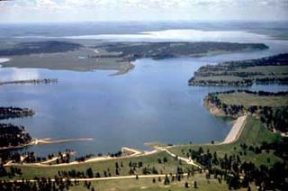
Keyhole State Park is a public recreation area surrounding Keyhole Reservoir, ten miles (16 km) northeast of Moorcroft in Crook County, Wyoming. The state park is managed by the Wyoming Division of State Parks and Historic Sites.
Bear River State Park is a public recreation area straddling the Bear River on the east side of the city of Evanston, Wyoming. The 324-acre (131 ha) state park was established in 1991 and is managed by Wyoming Division of State Parks and Historic Sites.

Boysen State Park is a public recreation area surrounding the Boysen Reservoir, an impoundment of the north-flowing Wind River, in Fremont County, Wyoming. The state park covers more than 35,000 acres (14,000 ha) at the south end of the Owl Creek Mountains at the mouth of the Wind River Canyon.

Curt Gowdy State Park is a public recreation area covering 3,395 acres in Albany and Laramie counties in Wyoming, United States. It is located on Wyoming Highway 210, halfway between Cheyenne and Laramie, about 24 miles (40 km) from each. The state park is known for its extensive trail system, fishing reservoirs, and Hynds Lodge, which is listed on the National Register of Historic Places. The park is managed by the Wyoming Division of State Parks and Historic Sites.

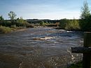
Sinks Canyon State Park is a public recreation and nature preservation area located in the Wind River Mountains, six miles (9.7 km) southwest of Lander, Wyoming, on Wyoming Highway 131. The state park is named for a portion of the Middle Fork of the Popo Agie River where it flows into an underground limestone cavern, named "the Sinks," and emerges a quarter-mile down the canyon in a pool named "the Rise." The park is managed by the Wyoming Division of State Parks and Historic Sites.

Edness K. Wilkins State Park is a public recreation area on the North Platte River located six miles (9.7 km) east of the city of Casper in Natrona County, Wyoming. The state park occupies the site of a former rock quarry that was purchased by the state in 1981 for $380,000. It was named after area resident Edness Kimball Wilkins (1896-1980), who served for 25 years in the Wyoming state legislature. The park encompasses 361 acres (146 ha) and offers picnicking, boating, fishing, swimming, and bird watching. The Audubon Society designated the park an Important Bird Area because of its extensive use during the spring and fall migrations, plus its large numbers of common nesting birds. It is managed by the Wyoming Division of State Parks and Historic Sites.
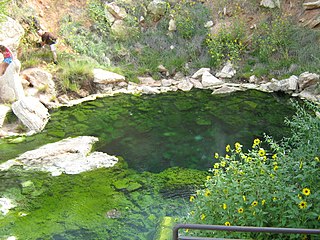
Hot Springs State Park is a public recreation area in Thermopolis, Wyoming, known for its hot springs, which flow at a constant temperature of 135 °F (57.2 °C). The state park offers free bathing at the State Bath House, where temperatures are moderated to a therapeutic 104 °F (40.0 °C). The petroglyph site at Legend Rock, some 25 miles (40 km) away, is also part of the park. The park is managed by the Wyoming Division of State Parks and Historic Sites.

There is evidence of prehistoric human habitation in the region known today as the U.S. state of Wyoming stretching back roughly 13,000 years. Stone projectile points associated with the Clovis, Folsom and Plano cultures have been discovered throughout Wyoming. Evidence from what is now Yellowstone National Park indicates the presence of vast continental trading networks since around 1,000 years ago.

Guernsey State Park is a public recreation area surrounding the Guernsey Reservoir, an impoundment of the North Platte River, one mile northwest of the town of Guernsey in Platte County, Wyoming. The state park has campgrounds, boat ramps and hiking trails as well as exceptional examples of structures created by the Civilian Conservation Corps in the 1930s. Facilities are managed for the Bureau of Reclamation by the Wyoming Division of State Parks and Historic Sites.

The following is an alphabetical list of articles related to the U.S. state of Wyoming.

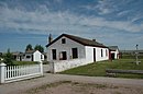
This is a list of the National Register of Historic Places listings in Johnson County, Wyoming. It is intended to be a complete list of the properties and districts on the National Register of Historic Places in Johnson County, Wyoming, United States. The locations of National Register properties and districts for which the latitude and longitude coordinates are included below, may be seen in an online map.

Names Hill is a bluff located on the bank of the Green River in the U.S. state of Wyoming, where travelers on the Oregon and California trails carved their names into the rock. It is one of three notable "recording areas" along the emigrant trails in Wyoming along with Register Cliff and Independence Rock. The site was listed on the National Register of Historic Places on April 16, 1969.

Glendo State Park is a public recreation area surrounding Glendo Reservoir on the North Platte River in Platte and Converse counties in Wyoming in the United States. The state park is located near the town of Glendo, about 20 miles (32 km) southeast of the city of Douglas. It is managed by the Wyoming Division of State Parks and Historic Sites.

Hawk Springs State Recreation Area is a public recreation area on Hawk Springs Reservoir, located ten miles (16 km) southeast of Hawk Springs and ten miles (16 km) north of La Grange in Goshen County, Wyoming. The state park occupies fifty-nine acres (24 ha) of land on the reservoir's western shore and is managed by the Wyoming State Parks, Historic Sites & Trails Division.

Seminoe State Park is a public recreation area located on the northwest side of the Seminoe Reservoir, at the base of the Seminoe Mountains, 35 miles (56 km) north of Sinclair, Carbon County, Wyoming. The state park encompasses 1,639 acres (663 ha) of land and offers access to 19,000 acres (7,700 ha) of water. It is managed by the Wyoming Division of State Parks and Historic Sites.