Alatna River

Last updated
Alatna River
Alatna.jpg
Confluence of Alatna and Koyukuk Rivers
Relief map of USA Alaska.png
Red pog.svg
Location
CountryUnited States
State Alaska
TypeWild
DesignatedDecember 2, 1980

The Alatna River[ pronunciation? ] is a federally designated wild and scenic river partially contained within the boundaries of Gates of the Arctic National Park, Alaska.

Contents

Geography

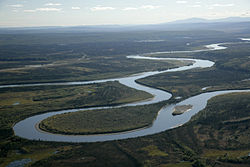
The Alatna River stems from the central Brooks Range flowing through the Endicott Mountains, passing Circle Lake, the Arrigetch Peaks and Takahula Lake before entering the Helpmejack Hills. The last section of the river continues to flow in a SSE direction through the Alatna Hills into its confluence with the Koyukuk River near the small village of Allakaket. The first 25 miles (40 km) of the Alatna are shallow and rocky, followed by 15 miles (24 km) of a continued shallow area with more rapids. The river then mellows out near Takahula and Circle Lake becoming deeper and more meandering while the scenery turns from mountain peaks into hilly boreal forest. According to The Alaska River Guide, this river is 184 miles (296 km) long from the headwaters to Allakaket and 137 miles (220 km) from Circle Lake to Allakaket.

Tourism

The river is very popular for float trips due to its calm flow and wonderful scenery. Float trips usually take from four to fourteen days, depending on put-in spot and pick-up spot, and also weather/river conditions. One common place to put in is Circle Lake, a small lake which is float plane accessible and is located in a beautiful part of the valley. Another place to put in is Takahula Lake, a larger, float-plane accessible lake, further downstream from Circle Lake. Gaedeke Lake is also a possible put in spot, but according to the Alaska River Guide, this upstream section near the headwaters of the river is shallow and rocky making portaging or lining necessary. Most floaters take out at the village of Allakaket.

Exploration

Bob Marshall made an exploratory mapping trip up the river in 1931, following the river drainage from Allakaket upstream, to the Kutuk River, and onwards to the Brooks Range. He was following in the footsteps of Philip Smith in 1911, the Murie brothers Olas and Adolph in 1923, and the Smith, Fitzgerald, and Mertie USGS trip of 1924. [1] [2] [3]

Related Research Articles

<span class="mw-page-title-main">Alatna, Alaska</span> CDP in Alaska, United States

Alatna is a census-designated place (CDP) in the Yukon-Koyukuk Census Area of the Unorganized Borough in the U.S. state of Alaska. The population was 35 at the 2020 census.

<span class="mw-page-title-main">Allakaket, Alaska</span> City in Alaska, United States

Allakaket is a second class city in the Yukon-Koyukuk Census Area of the Unorganized Borough of the U.S. state of Alaska. The population was 105 at the 2010 census.

<span class="mw-page-title-main">Gates of the Arctic National Park and Preserve</span> National park in Alaska, United States

Gates of the Arctic National Park and Preserve is an American national park that protects portions of the Brooks Range in northern Alaska. The park is the northernmost national park in the United States, situated entirely north of the Arctic Circle. The area of the park and preserve is the second largest in the U.S. at 8,472,506 acres ; the National Park portion is the second largest in the U.S., after the National Park portion of Wrangell–St. Elias National Park and Preserve.

<span class="mw-page-title-main">Kobuk River</span> River in the U.S. state of Alaska

The Kobuk River, also known by the names Kooak, Kowak, Kubuk, Kuvuk, and Putnam, is a river located in the Arctic region of northwestern Alaska in the United States. It is approximately 280 miles (451 km) long. Draining a basin with an area of 12,300 square miles (32,000 km2), the Kobuk River is among the largest rivers in northwest Alaska, with widths of up to 1,500 feet and flows reaching speeds of 3–5 miles per hour in its lower and middle reaches. The average elevation for the Kobuk River Basin is 1,300 feet (400 m) above sea level, ranging from sea level at its mouth on the Bering Sea to 11,400 feet near its headwaters in the Brooks Range.

<span class="mw-page-title-main">Koyukuk River</span> River in Alaska, United States

The Koyukuk River is a 425-mile (684 km) tributary of the Yukon River, in the U.S. state of Alaska. It is the last major tributary entering the Yukon before the larger river empties into the Bering Sea.

<span class="mw-page-title-main">Delta River</span> River in the United States of America

The Delta River is an 80-mile (130 km) tributary of the Tanana River in the U.S. state of Alaska. Its name in the Ahtna language is Saas Na’ . Fed by the Tangle Lakes of the Alaska Range, the river flows north to meet the larger river near Big Delta.

<span class="mw-page-title-main">Noatak River</span> River in the northwestern Alaska

The Noatak River is a river in the northwestern part of the U.S. state of Alaska.

<span class="mw-page-title-main">Noatak National Preserve</span> National Preserve along the Noatak River in northwestern Alaska

Noatak National Preserve is a United States National Preserve in northwestern Alaska that was established to protect the Noatak River Basin. The Noatak River system, located just north of the Arctic Circle, is thought to be the last remaining complete river system in the United States that has not been altered by human activities. The roadless basin was proclaimed a United States National Monument in 1978 and a National Preserve in 1980 through the passage of the Alaska National Interest Lands Conservation Act (ANILCA). Noatak National Preserve borders Kobuk Valley National Park on the south and Gates of the Arctic National Park on the east. Unlike the national parks that it borders, sport hunting is allowed in Noatak National Preserve.

<span class="mw-page-title-main">Andreafsky River</span> River in Alaska, United States

The Andreafsky River is a 120-mile (190 km) tributary of the Yukon River in the U.S. state of Alaska. The Andreafsky flows south from near Iprugalet Mountain in the Yukon Delta National Wildlife Refuge to meet the larger river at Pitkas Point, near the village of St. Mary's.

<span class="mw-page-title-main">Beaver Creek (Yukon River tributary)</span> River in Alaska, United States

Beaver Creek is a 180-mile (290 km) tributary of the Yukon River in the U.S. state of Alaska. The creek begins at the confluence of Champion and Bear creeks in the White Mountains National Recreation Area, about 50 miles (80 km) north of Fairbanks. From there it flows west around the southern end of the White Mountains, then northeast into the Yukon Flats National Wildlife Refuge, then west into the Yukon River downstream of Beaver.

<span class="mw-page-title-main">Chandalar River</span> River in the United States of America

The Chandalar River is a 100-mile (160 km) tributary of the Yukon River in the U.S. state of Alaska. Its peak flow, recorded by the United States Geological Survey (USGS) between 1964 and 1974 at a stream gauge at Venetie, was 62,800 cubic feet per second (1,780 m3/s) on June 9, 1968.

<span class="mw-page-title-main">Charley River</span> River in Alaska, United States

The Charley River is an 88-mile (142 km) tributary of the Yukon River in the U.S. state of Alaska. Flowing generally northeast from the Mertie Mountains in the northeastern part of the state, the river lies entirely within Yukon–Charley Rivers National Preserve. The Charley River enters the larger river downstream and 55 miles (89 km) northwest of Eagle.

<span class="mw-page-title-main">Gulkana River</span> River in Alaska, United States

The Gulkana River is a 60-mile (97 km) tributary of the Copper River in the U.S. state of Alaska. Beginning near the southeastern end of Summit Lake in the Alaska Range, the river flows generally south to meet the larger river 9 miles (14 km) northeast of Glennallen. The Richardson Highway and the Trans-Alaska Pipeline run north–south, nearby and roughly parallel to the Gulkana River. Slightly south of Summit Lake the river passes under the east–west Denali Highway near its junction with the Richardson Highway at Paxson.

<span class="mw-page-title-main">Ivishak River</span> River in Alaska, United States

The Ivishak River is a 95-mile (153 km) tributary of the Sagavanirktok River in the North Slope Borough of the U.S. state of Alaska. Fed by glaciers at the headwaters, the Ivishak flows northeast, then northwest, through the Philip Smith Mountains and the northern foothills of the Arctic National Wildlife Refuge. It enters the Sagavanirktok River on the coastal plain south of Prudhoe Bay.

<span class="mw-page-title-main">John River (Alaska)</span> River in Alaska, United States

The John River (Iñupiaq: Atchiiniq) is a 125-mile (201 km) tributary of the Koyukuk River in the northern part of the U.S. state of Alaska. It was named after John Bremner, a prospector and explorer who was one of the first non-native persons to go there. It flows south from Anaktuvuk Pass in Alaska's Brooks Range, into the larger river at a point near Bettles, slightly north of the Arctic Circle.

The Wind River is a tributary of the East Fork Chandalar River in the U.S. state of Alaska. It arises in the Philip Smith Mountains of the Brooks Range and flows into the East Fork and eventually into the Yukon River.

<span class="mw-page-title-main">Yukon–Charley Rivers National Preserve</span> United States national preserve in Alaska

Yukon–Charley Rivers National Preserve is a United States national preserve located in east central Alaska along the border with Canada. Managed by the National Park Service, the preserve encompasses 130 miles (208 km) of the 1,800-mile (3,000 km) Yukon River and the entire Charley River basin. The preserve protects the undeveloped Charley River and a significant portion of the upper Yukon. The interior Alaskan region experiences extremes of weather, with temperatures that can vary from −50 °F (−46 °C) in winter to 97 °F (36 °C) in summertime. The Yukon provided a means of access to the region, which is entirely roadless, during the late 19th century and early 20th centuries. Gold rushes in Alaska brought prospectors, who operated gold dredges to recover significant quantities of placer gold from area creeks. Today the preserve includes part of the route of the annual Yukon Quest dogsled race, which runs every February. During the summer float trips are popular on the Yukon and Charley Rivers.

<span class="mw-page-title-main">White Salmon River</span> American river in the state of Washington

The White Salmon River is a 44-mile (71 km) tributary of the Columbia River in the U.S. state of Washington. Originating on the slopes of Mount Adams, it flows into the Columbia Gorge near the community of Underwood. Parts of the river have been designated Wild and Scenic. The principal tributaries of the White Salmon River include Trout Lake and Buck, Mill, Dry, Gilmer, and Rattlesnake Creeks.

<span class="mw-page-title-main">Arrigetch Peaks</span> Cluster of mountains in Alaska

The Arrigetch Peaks are a cluster of rugged granite spires in the Endicott Mountains of the central Brooks Range in northern Alaska. The name Arrigetch means 'fingers of the outstretched hand' in the Inupiat language. The peaks ring the glacial cirques at the head of the Kobuk River and 2 tributaries of the Alatna River: Arrigetch Creek and Aiyagomahala Creek. They are located at latitude 67 degrees 24' N and longitude 154 degrees 10' W. All of the summits of the peaks are around 6,000 ft, 1825 m elevation. The Arrigetch Peaks area was designated as a National Natural Landmark in 1968 for its spectacular geography.

<span class="mw-page-title-main">North Fork Koyukuk River</span> River

The North Fork of the Koyukuk River is one of the principal forks of the Koyukuk River, approximately 105 mi (160 km) long, in northern Alaska in the United States. It has a watershed area of 1,850 square miles (4,800 km2). It rises on the south slopes of the Continental Divide in the Brooks Range.

References

  1. Marshall, Robert (1956). Marshall, George (ed.). Arctic Wilderness. Berkeley: University of California Press. pp. 82–99.
  2. "Government Geologists Cross Central Brooks Range". Gates of the Arctic. National Park Service. Retrieved 3 May 2020.
  3. Smith, Philip; Mertie, J.B. "Geology and Mineral Resources of Northwestern Alaska, USGS Bulletin 815". USGS. Retrieved 3 May 2020.