
Delta National Forest is a U.S. National Forest in western Mississippi, located in Sharkey County, and has an area of 60,898 acres (246.4 km2). Delta is operated as the Sunflower Wildlife Management Area. The forest is headquartered in Jackson, as are all six National Forests in Mississippi, but Delta Ranger District office is located in Rolling Fork. It is one of only six National Forests that are contained entirely within a single county and the only bottomland hardwood forest in the National Forest system.

The Allegheny Wildlife Management Area is located on 6,202 acres (25.1 km2) on two separate tracts of mixed oak-hickory woodlands in western Mineral County along the Allegheny Front. The large land tract of 5,034 acres (2,037.2 ha) is accessible via Pinnacle Road and Pine Swamp Road four miles (6 km) southwest of Keyser. The smaller tract of 1,168 acres (4.7 km2) is accessed by West Virginia Route 46 and Barnum Road about 6 miles (10 km) north from Elk Garden. The Barnum Road tract consists of old farm fields along the river and the ridgetop, connected by steep slopes.
Pocomoke River Wildlife Management Area is a state wildlife management area (WMA) of Maryland that lies on the south bank of the Pocomoke River in Worcester County. The Pocomoke River State Forest abuts the northern edge of the WMA.
E.A. Vaughn Wildlife Management Area is a state wildlife management area (WMA) of Maryland that consists of two separate parcels of land on Chincoteague Bay in Worcester County, between the villages of Girdletree and Stockton.
Isle of Wight Wildlife Management Area is a state wildlife management area (WMA) of Maryland located on the Isle of Wight, a small peninsula between the St. Martin's River and Isle of Wight Bay in Worcester County. Although called Isle of Wight, a small strip of marsh and road connects it with the mainland.

Indian Springs is an unincorporated community in western Washington County, Maryland, United States. Its population was 64 as of the 2010 census.

Land's End Wildlife Management Area is a 462-acre (187 ha) Wildlife Management Area (WMA) in southeastern King George County, Virginia. The site is a mixture of open farmland, woodland, and wetland, and comprises two separate tracts: The 50-acre (20 ha) Salem Church Tract, and the 412-acre (167 ha) Land's End Tract. The area is bordered on two sides by the Rappahannock River and on one by Jett's Creek, and is primarily managed as a refuge for migrating waterfowl; Canada geese can often be seen in the winter feeding on fields of corn, milo, and winter wheat in the area, and resting in the nearby Nanzatico Bay. Among the other species often seen on the property are bald eagles, deer, wild turkey, and songbirds.
Bowen Wildlife Management Area is a Wildlife Management Area in Prince George's County, Maryland. It was deeded by Harry L. Bowen to the state of Maryland in 1955 for $1.00. The area is 80 percent water-covered and is a popular site for waterfowl hunting and canoeing.

Deal Island Wildlife Management Area protects 13,565 acres (54.90 km2) in western Somerset County, Maryland near the community of Deal Island. As a wildlife management area, the area is managed by the Maryland Department of Natural Resources' Wildlife and Heritage Service to conserve wildlife populations and their habitats, while providing public recreational use of wildlife resources.

Dierssen Wildlife Management Area is a Wildlife Management Area (WMA) near Seneca in Montgomery County, Maryland.
Fishing Bay Wildlife Management Area is a Wildlife Management Area in Dorchester County, Maryland. The area is the largest wildlife management area in Maryland. Adjoining Blackwater National Wildlife Refuge, the area is about 80 percent tidal marshland.
Indian Springs Wildlife Management Area is a Wildlife Management Area in Washington County, Maryland near Clear Spring. The 6,400-acre (2,600 ha) tract is in wooded mountainous terrain.

Millington Wildlife Management Area is a 4,000-acre Wildlife Management Area in Kent County, Maryland. The area is ecologically diverse, featuring hardwood forests as well as various types of wetlands, fields, and meadows. Millington supports a large variety of wildlife, including, whitetail deer, turkeys, quail, rabbits, and waterfowl, as well as protecting a number of endangered plants and animals species. The site also provides outdoor recreation as well as hunting in all established seasons.
Gwynnbrook Wildlife Management Area is an 88-acre (36 ha) Wildlife Management Area in Owings Mills, Baltimore County, Maryland. The property is a former game farm that was purchased by Maryland in 1919, and is the oldest WMA in the state.

Purse State Park is a former Maryland state park located on the Potomac River in Charles County that has been subsumed into the 1,365-acre (552 ha) Nanjemoy Wildlife Management Area. As the Purse Area, the former park is known for fossil hunting on the beaches of Wades Bay at the southern end of the Nanjemoy WMA. Fossil discoveries have included shark teeth and Cibicides.

A Wildlife Management Area (WMA) is a protected area set aside for the conservation of wildlife and for recreational activities involving wildlife.
The Islands of the Potomac Wildlife Management Area is a Wildlife Management Area (WMA) consisting of 30 islands in the Potomac River in Maryland along its border with the state of Virginia. It is administered by the Maryland Department of Natural Resources.
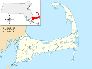
Frances A. Crane Wildlife Management Area is a wildlife management area (WMA) in Falmouth, Massachusetts, operated by the state Department of Fish and Game.
The Mills Cross Array, or the 96-acre antenna array, was a Mills Cross Telescope-style radio telescope located in Seneca Maryland, near Washington, D.C.. Constructed in June, 1954, it was operated by the Carnegie Institution of Washington. The full array consisted of two arms, each 2047 feet in length with 66 dipole antennas. The dipole antennas were supported by unpainted wooden poles, connected with wires. The telescope had around 5 miles (8.0 km) of wire, with an army surplus truck housing the phase-switching radio receiver. It was built to conduct a 22.2 MHz sky survey, and at that frequency it had a beam about 2.5 degrees wide.
