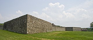
Fort Frederick State Park is a public recreation and historic preservation area on the Potomac River surrounding the restored Fort Frederick, a fortification active in the French and Indian War (1754–1763) and the American Revolutionary War (1775-1783). The state park lies south of the town of Big Pool, Maryland. The Chesapeake and Ohio Canal runs through the park grounds. The site was designated a National Historic Landmark in 1973.
Muirkirk is an unincorporated community in northern Prince George's County, Maryland, United States, located between Baltimore and Washington in the central part of the state.
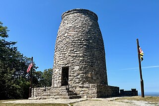
Washington Monument State Park is a public recreation area located approximately one mile (1.6 km) southeast of Boonsboro, Maryland. The park preserves the Washington Monument, a 40-foot-tall (12 m) tower honoring George Washington, the first President of the United States. The monument sits along the Appalachian Trail near the summit of South Mountain's Monument Knob. It was added to the National Register of Historic Places in 1972. The park is managed by the Maryland Department of Natural Resources.

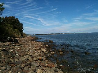
St. Clement's Island State Park is a publicly owned historic preservation and recreational area that encompasses St. Clement's Island, an uninhabited Potomac River island lying one-half mile southeast of Colton's Point, St. Mary's County, Maryland. The state park features a 40-foot stone cross dedicated to the beginnings of freedom of religion in the United States as well as a reconstruction of the historic Blakistone Island Light. It is the central feature of the St. Clement's Island Historic District that was listed on the National Register of Historic Places in 1972.

This is a list of sites in Minnesota which are included in the National Register of Historic Places. There are more than 1,700 properties and historic districts listed on the NRHP; each of Minnesota's 87 counties has at least 2 listings. Twenty-two sites are also National Historic Landmarks.

St. Charles College was a minor seminary in Catonsville, Maryland, originally located in Ellicott City, Maryland.

Swallow Falls State Park is a public recreation area located on the west bank of the Youghiogheny River nine miles (14 km) northwest of Oakland in Garrett County, Maryland, in the United States. The state park features Maryland's highest free-falling waterfall, the 53-foot (16 m) Muddy Creek Falls, as well as smaller waterfalls on the Youghiogheny River and Tolivar Creek. The park is notable for its stand of old hemlock trees, some more than 300 years old, "the last stand of its kind in Maryland."
North Point State Park is a public recreation area located on Chesapeake Bay in Edgemere, Baltimore County, Maryland. The state park includes the site of the former Bay Shore Park, which was one of the state's premiere amusement parks during the first half of the 20th century. The park features restored remnants of the old amusement park as well as facilities for swimming, picnicking, bicycling, and hiking. Black Marsh, a 667-acre (270 ha) state wildlands area, makes up half the park's area. The park is administered by the Maryland Department of Natural Resources.

The Casselman Bridge is a historic transportation structure on the Casselman River, located immediately east of Grantsville in Garrett County, Maryland, and preserved by the state of Maryland as Casselman River Bridge State Park. The bridge was built in 1813–1814 as part of the National Road. Historic markers posted at each end read:
Erected 1813 by David Shriver Jr.,
Sup't of the "Cumberland Road". This 80 foot span
was the largest stone arch in America
at the time. It was continuously
used from 1813 to 1933.

Rosaryville State Park is a public recreation area with historical features located three miles southeast of Joint Base Andrews in Rosaryville, Prince George's County, Maryland. The state park includes the restored Mount Airy Mansion, which was formerly operated as an event facility, as well as hiking, biking and equestrian trails for day-use.

Smallwood State Park is a public recreation and historic preservation area located on Mattawoman Creek near Marbury, Charles County, Maryland. The state park preserves Smallwood's Retreat, the plantation home of former Continental Army officer and Governor of Maryland, Major General William Smallwood. The park's 984 acres (398 ha) include a marina, boat ramps, picnicking facilities, campsites, cabins, trails, and nature center.
St. Mary's River State Park is a public recreation area located in St. Mary's County, Maryland. The state park consists of two sites: one encompasses 250-acre (100 ha) St. Mary's Lake; the second covers 2,200 acres (890 ha) and is largely undeveloped. The park is managed by the Maryland Department of Natural Resources.

This is a list of the National Register of Historic Places listings in Itasca County, Minnesota. It is intended to be a complete list of the properties and districts on the National Register of Historic Places in Itasca County, Minnesota, United States. The locations of National Register properties and districts for which the latitude and longitude coordinates are included below, may be seen in an online map.

Savage Mountain is an anticline extending from Bedford County, Pennsylvania southwest into Western Maryland. It is the western side of the Ridge-and-Valley Appalachians, and the eastern portion of the ridge forms the border of Garrett and Allegany Counties of Maryland.

This is a list of the National Register of Historic Places listings in Nobles County, Minnesota. It is intended to be a complete list of the properties and districts on the National Register of Historic Places in Nobles County, Minnesota, United States. The locations of National Register properties and districts for which the latitude and longitude coordinates are included below, may be seen in an online map.

The Maryland Historical Trust is an agency of Maryland Department of Planning and serves as the Maryland State Historic Preservation Office. The agency serves to assist in research, conservation, and education, of Maryland's historical and cultural heritage. The agency is responsible for the management of thousands of historical sites located within the State of Maryland.
A Smithsonian trinomial is a unique identifier assigned to archaeological sites in many states in the United States. Trinomials are composed of a one or two digit coding for the state, typically two letters coding for the county or county-equivalent within the state, and one or more sequential digits representing the order in which the site was listed in that county. The Smithsonian Institution developed the site number system in the 1930s and 1940s, but it no longer maintains the system. Trinomials are now assigned by the individual states. The 48 states then in the union were assigned numbers in alphabetical order. Alaska was assigned number 49 and Hawaii was assigned number 50, after those states were admitted to the union. There is no Smithsonian trinomial number assigned for the District of Columbia or any United States territory.

Pen Mar is an unincorporated community in Washington County, Maryland, United States. It is one of the border towns in the United States with a portmanteau name. Located on the Mason–Dixon line, it is bordered to the north by the community of Pen Mar, Pennsylvania. The community came to prominence as a resort in the 20th century after the construction of Pen Mar Park by the Western Maryland Railway. While the resort has long been dismantled, the area still has some significance in Maryland, since it is the northern starting point for the Maryland section of the Appalachian Trail.