Related Research Articles

Garrett County is the westernmost county of the U.S. state of Maryland. As of the 2020 census, the population was 28,806, making it the third-least populous county in Maryland. Its county seat is Oakland. The county was named for John Work Garrett (1820–1884), president of the Baltimore and Ohio Railroad. Created from Allegany County, Maryland in 1873, it was the last Maryland county to be formed.

Congaree National Park is a 26,692.6-acre American national park in central South Carolina, 18 miles southeast of the state capital, Columbia. The park preserves the largest tract of old growth bottomland hardwood forest left in the United States. The lush trees growing in its floodplain forest are some of the tallest in the eastern United States, forming one of the highest temperate deciduous forest canopies remaining in the world. The Congaree River flows through the park. About 15,000 acres are designated as a wilderness area.

Deep Creek Lake State Park is a public recreation area occupying more than 1,100 acres (450 ha) on the northeast side of Deep Creek Lake in Garrett County, Maryland, in the United States. The park features water activities, camping facilities, and recreational trails and is located about 18 miles (29 km) south of Interstate 68 on U.S. Route 219.

Rothrock State Forest is a Pennsylvania state forest in Pennsylvania Bureau of Forestry District #5. The main offices are located in Huntingdon in Huntingdon County, Pennsylvania in the United States.
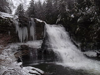
Swallow Falls State Park is a public recreation area located on the west bank of the Youghiogheny River nine miles (14 km) northwest of Oakland in Garrett County, Maryland, in the United States. The state park features Maryland's highest free-falling waterfall, the 53-foot (16 m) Muddy Creek Falls, as well as smaller waterfalls on the Youghiogheny River and Tolivar Creek. The park is notable for its stand of old hemlock trees, some more than 300 years old, "the last stand of its kind in Maryland."

Simon B. Elliott State Park is a 318-acre (129 ha) Pennsylvania state park located in Pine Township, Clearfield County, Pennsylvania in the United States. The park is surrounded by Moshannon State Forest. The park is entirely wooded with second growth forests of mixed oak species, including northern red oak, chestnut oak, shagbark hickory, red maple, and tulip poplar, and northern hard woods, including sugar maple, black cherry, aspen, birch, hemlock, and ash. S. B. Elliott State park is 9 miles (14 km) north of Clearfield on Pennsylvania Route 153 just off exit 111 of Interstate 80.
The Maryland Forest Service in 1996 marked the 90th anniversary of forestry in Maryland, United States and the birth of what is known as the Department of Natural Resources Forest Service. Although the service has been known by many names over nine decades, its mission has been consistent: "To conserve and enhance the quality, quantity, productivity and biological diversity of the forest and tree resources of Maryland."
Herrington Manor State Park is a public recreation area on 365 acres (148 ha) in Garrett County, Maryland. The focal point of the state park is 53-acre (21 ha) Herrington Lake. The park lies adjacent to Swallow Falls State Park, approximately 4 miles (6.4 km) north of Oakland. Both parks are managed by the Maryland Department of Natural Resources.

Cunningham Falls State Park is a public recreation area located west of Thurmont, Maryland, in the United States. The state park is the home of Cunningham Falls, the largest cascading waterfall in Maryland, a 43-acre (17 ha) man-made lake, and the remains of a historic iron furnace. The park is one of several protected areas occupying 50-mile-long Catoctin Mountain; it is bordered on its north by Catoctin Mountain Park and on its south by Frederick Municipal Forest.

Patapsco Valley State Park is a Maryland state park extending along 32 miles (51 km) of the Patapsco River south and west of the city of Baltimore, Maryland. The park encompasses multiple developed areas on over 14,000 acres (5,700 ha) acres of land, making it Maryland's largest state park. In 2006, it was officially celebrated as Maryland's first state park, its first formation being in 1906. Patapsco Valley State Park is managed by the Maryland Department of Natural Resources.

Big Run State Park is a public recreation area located at the northern end of the Savage River Reservoir, an impoundment of the Savage River, in Garrett County, Maryland. The state park occupies 300 acres (120 ha) in Savage River State Forest and encompasses the confluence of Monroe Run and Big Run. Park activities include boating, fishing, hiking, picknicking, and camping.

Cedarville State Forest is a state forest and protected area in the state of Maryland, near Brandywine, Cedarville, and Waldorf. It offers trails, campsites, a fishing pond, hunting land, and picnic and recreation areas. Trails are available for hikers, bikers and horse riders.
Elk Neck State Forest belongs to the Maryland Department of Natural Resources and is managed by the Maryland Forest Service, and is adjacent to the town of North East, in Cecil County. It is often confused with Elk Neck State Park, which lies further south, near the end of the same peninsula.

Greenbrier State Park is a public recreation area located on South Mountain, three miles (4.8 km) northeast of Boonsboro in Washington County, Maryland, USA. The state park has camping, hiking trails, and a 42-acre (17 ha) man-made lake. It is managed by the Maryland Department of Natural Resources.
Potomac State Forest is an 11,535-acre state forest in the state of Maryland near Oakland.

Savage River State Forest is located in the north and northeastern part of Garrett County, in the U.S. state of Maryland. The state forest has many waterways, including Savage River Reservoir, which was built in 1952 by the U.S. Army. The dam was built as an emergency water supply for Washington, D.C. Savage River State Forest is known for its hunting, fishing, camping, and hiking trails.
The Youghiogheny Scenic & Wild River is a river given special protected status by the state of Maryland. This wild and scenic portion of the Youghiogheny River is located in Western Garrett County, in Western Maryland. The Yough drains an area comprising approximately 397 square miles (1,030 km2) in Maryland, flowing through forests and farms. It rises from the west side of Backbone Mountain in Preston County, West Virginia, near the state's border with Garrett County.
Anders Run Natural Area is a 96-acre (39 ha) protected area in Warren County, Pennsylvania. It is part of Cornplanter State Forest.
Zekiah Swamp is part of the Potomac River basin in Charles County, Maryland in the United States. The swamp is 21 miles (34 km) of braided stream stretching the length of Charles County and is a tributary of the Potomac River. It sits at an elevation of three feet (0.91 m) and 450 acres (180 ha) of its southern end is protected as the Zekiah Swamp Natural Environment Area. The Maryland Department of Natural Resources has the authority to purchase an additional 5,000 acres (2,000 ha) for the park. Charles County has moved to protect an additional 65,000 acres (26,000 ha) of the wetland. The headwaters of the swamp are protected as part of Cedarville State Forest. It was first accurately surveyed by John Henry Alexander, Maryland's official cartographer, in 1835, as "Allen's Fresh".
Quebec Run Wild Area is a 7,441-acre section of Forbes State Forest located in Fayette County, Pennsylvania just north of the Mason–Dixon line and the Pennsylvania border with West Virginia. Situated on the eastern slope of Chestnut Ridge, one of the westernmost ridges in the Appalachian Mountain Range, Quebec Run is heavily forested and contains several miles of maintained, interconnected trail. As is the case with all Pennsylvania state forest wild areas, no development of a permanent nature is permitted “in order to retain the undeveloped character of the area.” Quebec Run is the largest wild area without a road in southwestern Pennsylvania and serves as a destination for various outdoor activities including hiking, mountain biking, and cross-country skiing.
References
- ↑ "A Brief History of the Forest Service". MD Dept. of Natural Resources. Retrieved January 20, 2018.
- ↑ "State Forests in Western Maryland". MD DNR Forest Service. Retrieved January 20, 2018.
- 1 2 "Garrett State Forest". MD Dept. of Natural Resources. Retrieved January 20, 2018.
- ↑ "Hiking — Garrett State Forest". West Virginia University - DIY Outdoors. Retrieved January 20, 2018.
- ↑ "Garrett State Forest - Kindness Demonstration Area". Maryland Forest Service. Maryland Department of Natural Resources . Retrieved January 20, 2018.