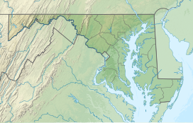
Washington County is a county located in the U.S. state of Maryland. The population was 154,705 as of the 2020 census. Its county seat and largest city is Hagerstown. The county is part of the Western Maryland region of the state.

Darnestown is a United States census-designated place (CDP) and an unincorporated area in Montgomery County, Maryland. The CDP is 17.70 square miles (45.8 km2) with the Potomac River as its southern border and the Muddy Branch as much of its eastern border. Seneca Creek borders portions of its north and west sides. The Travilah, North Potomac, and Germantown census-designated places are adjacent to it, as is the city of Gaithersburg. Land area for the CDP is 16.39 square miles (42.4 km2). As of the 2020 census, the Darnestown CDP had a population of 6,723, while the village of Darnestown is considerably smaller in size and population. Downtown Washington, D.C. is about 22 miles (35 km) to the southeast.

State parks are parks or other protected areas managed at the sub-national level within those nations which use "state" as a political subdivision. State parks are typically established by a state to preserve a location on account of its natural beauty, historic interest, or recreational potential. There are state parks under the administration of the government of each U.S. state, some of the Mexican states, and in Brazil. The term is also used in the Australian states of Victoria and New South Wales. The equivalent term used in Canada, Argentina, South Africa, and Belgium, is provincial park. Similar systems of local government maintained parks exist in other countries, but the terminology varies.

The Fort Wayne Old City Hall Building in downtown Fort Wayne, Indiana operates as a museum known as The History Center, and has served as headquarters for the Allen County–Fort Wayne Historical Society since 1980. The Richardsonian Romanesque style sandstone building was designed by the architectural firm Wing & Mahurin and built in 1893. It served as a functioning city hall for the city until 1971 when local officials moved to the City-County Building.

Starved Rock State Park is a state park in the U.S. state of Illinois, characterized by the many canyons within its 2,630 acres (1,064 ha). Located just southeast of the village of Utica, in Deer Park Township, LaSalle County, Illinois, along the south bank of the Illinois River, the park hosts over two million visitors annually, the most for any Illinois state park.
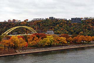
Point State Park is a Pennsylvania state park which is located on 36 acres (150,000 m2) in Downtown Pittsburgh, Allegheny County, Pennsylvania, USA, at the confluence of the Allegheny and Monongahela rivers, forming the Ohio River.
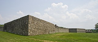
Fort Frederick State Park is a public recreation and historic preservation area on the Potomac River surrounding the restored Fort Frederick, a fortification active in the French and Indian War (1754–1763) and the American Revolutionary War (1775-1783). The state park lies south of the town of Big Pool, Maryland. The Chesapeake and Ohio Canal runs through the park grounds. The site was designated a National Historic Landmark in 1973.

St. Clement's Island State Park is a publicly owned historic preservation and recreational area that encompasses St. Clement's Island, an uninhabited Potomac River island lying one-half mile southeast of Colton's Point, St. Mary's County, Maryland. The state park features a 40-foot stone cross dedicated to the beginnings of freedom of religion in the United States as well as a reconstruction of the historic Blakistone Island Light. It is the central feature of the St. Clement's Island Historic District that was listed on the National Register of Historic Places in 1972.

The Western Maryland Rail Trail (WMRT) is a 28-mile (45 km) shared-use rail trail in the U.S. state of Maryland that follows the former right-of-way of the Western Maryland Railway (WM) between Fort Frederick State Park and Little Orleans via Hancock, paralleling the C&O Canal and Potomac River. The asphalt-paved trail is suitable for walking, jogging, biking, rollerblading, country skiing, and snowshoeing.

The Thomas Viaduct spans the Patapsco River and Patapsco Valley between Relay, Maryland and Elkridge, Maryland, USA. It was commissioned by the Baltimore and Ohio Railroad (B&O); built between July 4, 1833, and July 4, 1835; and named for Philip E. Thomas, the company's first president. Some claim it to be the world's oldest multiple arched stone railroad bridge. However, the Sankey Viaduct on the Liverpool and Manchester Railway was opened in 1830 and finally completed in 1833.

Maryland Route 144 is a collection of state highways in the U.S. state of Maryland. These highways are sections of old alignment of U.S. Route 40 between Cumberland and Baltimore. Along with US 40 Scenic, US 40 Alternate, and a few sections of county-maintained highway, MD 144 is assigned to what was once the main highway between the two cities, connecting those endpoints with Hancock, Hagerstown, Frederick, New Market, Mount Airy, Ellicott City, and Catonsville. MD 144 has seven disjoint sections of mainline highway that pass through the Appalachian Mountains in Allegany and Washington counties and the rolling Piedmont of Frederick, Carroll, Howard, and Baltimore counties.

Buchanan's Birthplace State Park is an 18.5-acre (7.5 ha) Pennsylvania state park near Cove Gap in Peters Township, Franklin County, Pennsylvania. The park is on Pennsylvania Route 16 along Tuscarora Mountain. Buchanan's Birthplace State Park was created from land donated to the state by Harriet Lane in honor of her uncle, the 15th President of the United States, James Buchanan.

Big Pool is an unincorporated community and census-designated place in western Washington County, Maryland, United States. Its population was 82 as of the 2010 census. It is between Clear Spring, Maryland and Hancock, Maryland along Interstate 70 and is officially a part of the Hagerstown Metropolitan Area.

The Casselman Bridge is a historic transportation structure on the Casselman River, located immediately east of Grantsville in Garrett County, Maryland, and preserved by the state of Maryland as Casselman River Bridge State Park. The bridge was built in 1813–1814 as part of the National Road. Historic markers posted at each end read:
Erected 1813 by David Shriver Jr.,
Sup't of the "Cumberland Road". This 80 foot span
was the largest stone arch in America
at the time. It was continuously
used from 1813 to 1933.

Rosaryville State Park is a public recreation area with historical features located three miles southeast of Joint Base Andrews in Rosaryville, Prince George's County, Maryland. The state park includes the restored Mount Airy Mansion, which was formerly operated as an event facility, as well as hiking, biking and equestrian trails for day-use.

South Mountain State Park is a public recreation area that runs for nearly the entire length of South Mountain through Washington and Frederick counties in Maryland. The state park is contiguous with several other national, state and local parks on the mountain, including the Chesapeake and Ohio Canal National Historical Park, Gathland State Park, Washington Monument State Park, Greenbrier State Park and Pen Mar County Park.

Nolands Ferry I Archeological Site is an archaeological site near the historic Noland's Ferry boat landing at mile 44.58 on the C&O Canal and Tuscarora. The Archeological Site is a prehistoric occupation site located in the Monocacy region of southern Frederick County, Maryland. Diagnostic artifacts at the site indicate that the site was almost continuously inhabited from the Paleo-Indian period to the early 19th century, with the most substantial inhabitation occurring during the Late Woodland period.

Fort Davidson, a fortification near the town of Pilot Knob, Missouri, was the site of the Battle of Fort Davidson during the American Civil War. Built by Union Army soldiers during the American Civil War, the fort repulsed Confederate attacks during the Battle of Fort Davidson on September 27, 1864, during Price's Raid. That night, the Union garrison blew up the fort's magazine and abandoned the site. A mass grave was constructed on the site to bury battlefield dead. After the war, the area was used by a mining company, before passing into private hands and eventually the administration of the United States Forest Service. In 1968, the Battle of Pilot Knob State Historic Site was created as a Missouri State Park. The fort itself was added to the National Register of Historic Places in 1970. As of 2020, a visitors center containing a museum is located within the park. The museum contains a fiber optic display, as well as artifacts including Brigadier General Thomas Ewing Jr.'s sword. The fort's walls are still visible, as is the crater created when the magazine was detonated. A monument marks the location of the mass grave.
A Smithsonian trinomial is a unique identifier assigned to archaeological sites in many states in the United States. Trinomials are composed of a one or two digit coding for the state, typically two letters coding for the county or county-equivalent within the state, and one or more sequential digits representing the order in which the site was listed in that county. The Smithsonian Institution developed the site number system in the 1930s and 1940s, but it no longer maintains the system. Trinomials are now assigned by the individual states. The 48 states then in the union were assigned numbers in alphabetical order. Alaska was assigned number 49 and Hawaii was assigned number 50, after those states were admitted to the union. There is no Smithsonian trinomial number assigned for the District of Columbia or any United States territory.