
Stafford County is located in the Commonwealth of Virginia. It is a suburb outside of Washington D.C. It is approximately 40 miles (64 km) south of D.C. It is part of the Northern Virginia region, and the D.C area. It is one of the fastest growing, and highest-income counties in America. As of the 2020 census, the population sits at 156,927. Its county seat is Stafford.
Fredericksburg is an independent city located in the Commonwealth of Virginia in the United States. As of the 2020 census, the population was 27,982. The Bureau of Economic Analysis of the United States Department of Commerce combines the city of Fredericksburg with neighboring Spotsylvania County for statistical purposes.

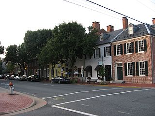
Falmouth is a census-designated place (CDP) in Stafford County, Virginia, United States. Situated on the north bank of the Rappahannock River at the falls, the community is north of and opposite the city of Fredericksburg. Recognized by the U.S. Census Bureau as a census-designated place (CDP), Falmouth's population was 4,274 as of the 2010 census.
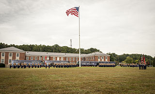
Marine Corps Base Quantico is a United States Marine Corps installation located near Triangle, Virginia, covering nearly 55,148 acres (86.169 sq mi) of southern Prince William County, Virginia, northern Stafford County, and southeastern Fauquier County. Used primarily for training purposes, MCB Quantico is known as the "Crossroads of the Marine Corps".

The Chesapeake and Ohio Canal National Historical Park is located in the District of Columbia and the state of Maryland. The park was established in 1961 as a National Monument by President Dwight D. Eisenhower to preserve the neglected remains of the Chesapeake and Ohio Canal and many of its original structures. The canal and towpath trail extends along the Potomac River from Georgetown, Washington, D.C., to Cumberland, Maryland, a distance of 184.5 miles (296.9 km). In 2013, the path was designated as the first section of U.S. Bicycle Route 50.

Germanna Community College (GCC) is a community college in Virginia with campuses in Locust Grove, Fredericksburg, Stafford and Culpeper. Founded in 1970, it takes its name from Germanna, a settlement founded by Governor Alexander Spotswood for a group of German miners by the Rapidan River at what is now Germanna Ford.

Nanjemoy is a settlement along Maryland Route 6 in southwestern Charles County, Maryland, United States, and the surrounding large rural area more or less bounded by Nanjemoy Creek to the east and north, and the Potomac River to the south and west.
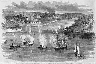
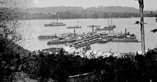
The Battle of Aquia Creek was an exchange of cannon fire between Union Navy gunboats and Confederate shore batteries on the Potomac River at its confluence with Aquia Creek in Stafford County, Virginia. The battle took place from May 29, 1861 to June 1, 1861 during the early days of the American Civil War. The Confederates set up several shore batteries to block Union military and commercial vessels from moving in the Chesapeake Bay and along the lower Potomac River as well as for defensive purposes. The battery at Aquia also was intended to protect the railroad terminal at that location. The Union forces sought to destroy or remove these batteries as part of the effort to blockade Confederate States coastal and Chesapeake Bay ports. The battle was tactically inconclusive. Each side inflicted little damage and no serious casualties on the other. The Union vessels were unable to dislodge the Confederates from their positions or to inflict serious casualties on their garrisons or serious damage to their batteries. The Confederates manning the batteries were unable to inflict serious casualties on the Union sailors or cause serious damage to the Union vessels. Soon after the battle, on Sunday, July 7, 1861, the Confederates first used naval mines, unsuccessfully, off the Aquia Landing batteries. The Confederates ultimately abandoned the batteries on March 9, 1862 as they moved forces to meet the threat created by the Union Army's Peninsula Campaign. The U. S. National Park Service includes this engagement in its list of 384 principal battles of the American Civil War.

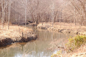
Aquia Creek is a 27.6-mile-long (44.4 km) tributary of the tidal segment of the Potomac River and is located in northern Virginia. The creek's headwaters lie in southeastern Fauquier County, and it empties into the Potomac at Brent Point in Stafford County, 45 miles (72 km) south of Washington, D.C.
Chopawamsic Creek is a 6.8-mile-long (10.9 km) tributary of the Potomac River in Prince William and Stafford counties, Virginia. Chopawamsic Creek is formed by the confluence of the North and South Branches of Chopawamsic Creek and empties into the Potomac River south of Quantico at the Marine Corps Base Quantico's Air Station. Breckenridge Reservoir lies at the stream's confluence with the North and South Branches. Along with its North Branch, Chopawamsic Creek forms part of the boundary between Prince William and Stafford counties. The North Branch flows through part of the Chopawamsic Backcountry Area in Prince William Forest Park.
Patawomeck is a Native American tribe based in Stafford County, Virginia, along the Potomac River. It is one of Virginia's eleven state recognized Native American tribes. It is however not federally recognized. It achieved state recognition in February 2010. In the 17th century, at the time of early English colonization, the Patawomeck tribe was a "fringe" component of the Powhatan Confederacy. At times it was allied with others in the confederacy, and at others, the Patawomeck allied with the English colonists.

Crow's Nest Natural Area Preserve is a large wilderness area located on the southern border of Stafford County, Virginia, United States, between Potomac Creek and Accokeek Creek. The greater portion of the Crow's Nest Peninsula is approximately 3,800 acres (15 km2) and lies within the coastal plain of Virginia. About 2,872 acres (11.62 km2) of the peninsula is protected as part of the Virginia Natural Area Preserve System.
Brooke is an unincorporated community in Stafford County, Virginia, United States.

Aquia Creek sandstone is a type of brown to light-gray freestone used extensively in building construction in Washington, D.C. in the late 18th and early 19th centuries. Quarried at Aquia Creek in Stafford County, Virginia, the stone was valuable for its ease of shaping and the quarry's proximity to the tidewater portion of the Potomac River, 45 miles south of Washington.

The Public Quarry at Government Island in Stafford County, Virginia is the principal source of Aquia Creek sandstone, a building stone used in many of the early government buildings in Washington, D.C., including the U.S. Capitol and the White House. A quarry was established just off the Potomac River at Wigginton's Island on Aquia Creek by George Brent after 1694, providing stone for tombstones and to houses and churches in northern Virginia, including Gunston Hall, Christ Church in Alexandria, Virginia, Mount Airy in Richmond County, Virginia, and Aquia Church, as well as steps and walkways at George Washington's Mount Vernon. Washington selected Aquia sandstone as the primary material for use in Washington's government buildings. Acting on the government's behalf, the Wigginton's Island quarry was purchased by Pierre Charles L'Enfant in 1791, becoming known afterward as Government Island.

The Potomac Creek Bridge was first built in 1842 by the Richmond, Fredericksburg and Potomac Railroad across the Potomac Creek in Stafford County, Virginia, United States.
Aquia is a district of Stafford County, in the U.S. state of Virginia. It is named for Aquia Creek, which leads to the Potomac River. Nearby historic locations include Aquia Church and the remains of Aquia quarry. Cliffs of the local Aquia Creek sandstone had been visible from the Potomac River near its confluence with Aquia Creek during colonial times. It was quarried to construct many buildings nearby, as well as in Washington, D.C., including the White House, National Capitol Columns and Washington Monument. It was a stop on the Richmond, Fredericksburg and Potomac Railroad which was replaced by, CSXT.
Tacketts Mill is an unincorporated community in Stafford County, in the U.S. state of Virginia.
Widewater is an unincorporated community in Stafford County, in the U.S. state of Virginia. Located on the banks of the Potomac River, it was the site of the flight experiments by Samuel Langley during the late 19th and early 20th century. It was a stop on the Richmond, Fredericksburg and Potomac Railroad which was replaced by CSX Transportation.
Belle Plains, Virginia was a steamboat landing and unincorporated settlement on the south bank of Potomac Creek off the Potomac River, in Stafford County, Virginia.


