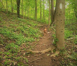
The Appalachian Trail, also called the A.T., is a hiking trail in the Eastern United States, extending almost 2,200 miles (3,540 km) between Springer Mountain in Georgia and Mount Katahdin in Maine, and passing through 14 states. The Appalachian Trail Conservancy claims the Appalachian Trail to be the world's longest hiking-only trail. More than three million people hike segments of it each year.

The George Washington and Jefferson National Forests is an administrative entity combining two U.S. National Forests into one of the largest areas of public land in the Eastern United States. The forests cover 1.8 million acres (2,800 sq mi) of land in the Appalachian Mountains of Virginia, West Virginia, and Kentucky. Approximately 1 million acres (1,600 sq mi) of the forest are remote and undeveloped and 139,461 acres (218 sq mi) have been designated as wilderness areas, which prohibits future development.

Mount Rogers National Recreation Area is a United States national recreation area (NRA) in southwestern Virginia near the border with Tennessee and North Carolina. It centerpiece is the Lewis Fork Wilderness containing Mount Rogers, the highest point in the state of Virginia with a summit elevation of 5,729 feet. The recreation area is under the jurisdiction of the George Washington and Jefferson National Forests. The recreation area was established by an act of the United States Congress on May 31, 1966.
The Appalachian National Scenic Trail spans 14 U.S. states over its roughly 2,200 miles (3,500 km): Georgia, North Carolina, Tennessee, Virginia, West Virginia, Maryland, Pennsylvania, New Jersey, New York, Connecticut, Massachusetts, Vermont, New Hampshire, and Maine. The southern end is at Springer Mountain, Georgia, and it follows the ridgeline of the Appalachian Mountains, crossing many of its highest peaks and running almost continuously through wilderness before reaching the northern end at Mount Katahdin, Maine.

The Priest (DePriest) is a mountain in Nelson County, Virginia. The peak of the mountain is the highest point in the county. The mountain is on a spur off the main Blue Ridge Mountains, about 3.5 miles (5.5 km) east of Maintop Mountain, located in the Priest Wilderness of the George Washington National Forest.
Mountain Lake Wilderness is a U.S. Wilderness Area in the George Washington and Jefferson National Forests. The wilderness area is located next to privately owned Mountain Lake, and consists of 8,314 acres (3,365 ha) in Virginia and 2,721 acres (1,101 ha) in West Virginia.
Ramsey's Draft Wilderness is a designated wilderness area in the North River Ranger District of the George Washington and Jefferson National Forests of Virginia in the United States. The wilderness area was established in 1984 and comprises 6,518 acres (26.38 km2). It is administered by the US Forest Service.
The Priest Wilderness is a U.S. Wilderness Area in the Glenwood/Pedlar Ranger District of the George Washington and Jefferson National Forests. The wilderness area is located just south of the Tye River, the Three Ridges Wilderness, and Virginia State Route 56. The wilderness consists of 5,726 acres (23.17 km2) and ranges in elevation from 1,000 feet (305 m) at the Tye River to 4,063 feet (1,238 m) at the summit of The Priest.

Barbours Creek Wilderness is a U.S. wilderness area in the Eastern Divide Ranger District of George Washington and Jefferson National Forests of western Virginia, United States. The wilderness area was established in 1988 and consists of 5,382 acres (2,178 ha) of forests in the Appalachian Mountains ranging in elevation from 1,700 to 3,800 feet.

The James River Face Wilderness is an 8,907-acre area located near Natural Bridge, Virginia that is protected by the Eastern Wilderness Act of Congress to maintain its present, natural condition. As part of the National Wilderness Preservation System, it helps to preserve a variety of natural life forms and contributes to a diversity of plant and animal gene pools. Over half of the ecosystems in the United States exist within designated wilderness.

White Oak Ridge-Terrapin Mountain is a wildland in the George Washington and Jefferson National Forests of western Virginia that has been recognized by the Wilderness Society as a special place worthy of protection from logging and road construction. With over 1200 acres of possible old growth forest, this is a rugged area with a rich diversity of geology and plant life.

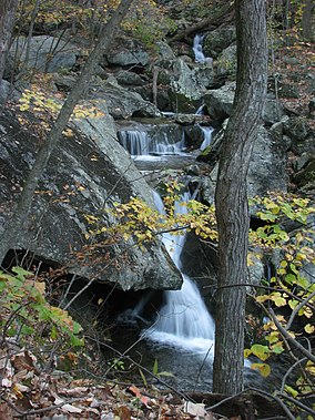
North Creek (conservation area) is a wildland in the George Washington and Jefferson National Forests of western Virginia that has been recognized by the Wilderness Society as a special place worthy of protection from logging and road construction. Tall evergreen and hardwood trees in the area around Apple Orchard Falls tower above ferns and wildflowers. The area includes a valley which extends from Sunset Fields in the east to its western border near the North Creek Camping Area.
James River Face Wilderness Addition is a wildland in the George Washington and Jefferson National Forests of western Virginia that has been recognized by the Wilderness Society as a special place worthy of protection from logging and road construction. Adjacent to the James River Face Wilderness, it extends the wildland opportunities of the wilderness on the east to the Jefferson National Forest boundary. The area, managed for bear, has hardwood forests with ages between 60 and almost 100 years.
Wilson Mountain is a wildland in the George Washington and Jefferson National Forests of western Virginia that has been recognized by the Wilderness Society as a special place worthy of protection from logging and road construction.
Cove Mountain is a wildland in the George Washington and Jefferson National Forests of western Virginia that has been recognized by the Wilderness Society as a special place worthy of protection from logging and road construction.
The Glenwood Cluster is a region in the George Washington and Jefferson National Forests recognized by The Wilderness Society for its rich biodiversity, scenery, wildflower displays, cold-water trout streams and horse trails. It offers a unique habitat for rare plants, salamanders and other rare species. The Blue Ridge Parkway and the Appalachian Trail traverse the area, giving ready access with views to the east of the Piedmont region and to the west of the Valley of Virginia.
The Barbours Creek-Shawvers Run Cluster is a region in the Jefferson National Forest recognized by The Wilderness Society for its unique high elevation mountains, vistas, trout streams and wildlife habitat. With over 25,000 acres in a remote corner of the national forest, the cluster provides protection for black bear, clean water and backcountry hiking.
The Angels Rest Cluster is a region in the Jefferson National Forest recognized by The Wilderness Society for its diversity of habitats with steep mountains, an isolated valley, a waterfall and wetlands. It is named after a high point on Pearis Mountain with views of the New River and surrounding area. It contains two large wild areas connected by the Appalachian Trail.
Brushy Mountain, a wildland in the George Washington and Jefferson National Forests of western Virginia, has been recognized by the Wilderness Society as a special place worthy of protection from logging and road construction. The Wilderness Society has designated the area as a "Mountain Treasure".
Beartown Wilderness Addition B, a wildland in the George Washington and Jefferson National Forests of western Virginia, has been recognized by the Wilderness Society as a special place worthy of protection from logging and road construction. The Wilderness Society has designated the area as a "Mountain Treasure". The area. adjacent to the Beartown Wilderness, is proposed as an addition to the wilderness.