
Russell County is a county located in the Commonwealth of Virginia. As of the 2020 census, the population was 25,781. Its county seat is Lebanon.

Tazewell County is a county located in the southwestern portion of the U.S. state of Virginia. As of the 2020 census, the population was 40,429. Its county seat is Tazewell.
Nanjemoy is a settlement along Maryland Route 6 in southwestern Charles County, Maryland, United States, and the surrounding large rural area more or less bounded by Nanjemoy Creek to the east and north, and the Potomac River to the south and west.

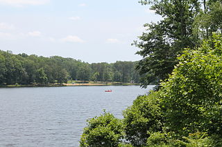
Claytor Lake State Park is a 472-acre (191 ha) state park in Pulaski County, Virginia. The park is located on Claytor Lake, a 4,500-acre (18 km2), 21-mile-long (34 km) reservoir on the New River formed by Claytor Dam, which is used to generate hydroelectric power by the Appalachian Power Company. The reservoir is named for W. Graham Claytor (1886–1971) of nearby Roanoke, a former vice president of Appalachian Power who supervised construction of the dam and creation of the lake.

False Cape State Park is a 4,321-acre (17.49 km2) state park located on the Currituck Banks Peninsula, a one-mile-wide (1.6 km) barrier spit between the Back Bay of the Currituck Sound and the Atlantic Ocean, within the city of Virginia Beach, adjacent to the state border with North Carolina, and just north of Mackay Island National Wildlife Refuge.

Breaks Interstate Park, also known as "the Breaks," is a bi-state state park located partly in southeastern Kentucky and southwestern Virginia in the Jefferson National Forest, at the northeastern terminus of Pine Mountain. The land is managed by an interstate compact between the states of Virginia and Kentucky. It is one of two interstate parks in the United States operated jointly under a compact rather than as two separate state park units. The Virginia Department of Conservation and Recreation and the Kentucky Department of Parks are still major partner organizations.

Belle Isle State Park is located in Lancaster County, Virginia, on the Rappahannock River. It sits between Deep Creek and Morattico Creek and is currently under public ownership. The park has an area of 892 acres (3.61 km2) and has facilities for camping, fishing, boating and picnics. As of 2015, the yearly visitation was 44,502.
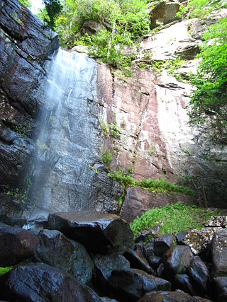
Bad Branch Falls State Nature Preserve is a forested gorge covering 2,639 acres near Whitesburg, KY in Letcher County, Kentucky. The deep and narrow gorge, adjacent to the Jefferson National Forest is carved into the face of Pine Mountain. Sandstone boulders and cliffs along with riglines and knobs provide views into the Appalachia area. The terrain is landscaped with streams, rivers, and a 60-foot waterfall. With a variety of habitat types, this nature preserve is home to many unique and unknown species of flora and fauna.
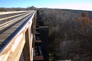
High Bridge Trail State Park is a rail trail in Southside Virginia converted from a rail line last belonging to Norfolk Southern.
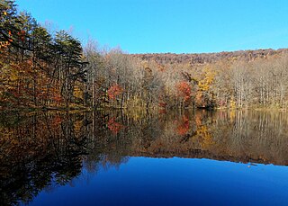
Bear Creek Lake State Park is a 326-acre (132 ha) state park located in Cumberland, Virginia, United States. It is a recreational and camping facility that surrounds an artificial 40-acre (16 ha) lake situated in the 16,000-acre (6,500 ha) Cumberland State Forest. As of 2013, the yearly visitation was 78,288.

According to the California Protected Areas Database (CPAD), in the state of California, United States, there are over 14,000 inventoried protected areas administered by public agencies and non-profits. In addition, there are private conservation areas and other easements. They include almost one-third of California's scenic coastline, including coastal wetlands, estuaries, beaches, and dune systems. The California State Parks system alone has 270 units and covers 1.3 million acres (5,300 km2), with over 280 miles (450 km) of coastline, 625 miles (1,006 km) of lake and river frontage, nearly 18,000 campsites, and 3,000 miles (5,000 km) of hiking, biking, and equestrian trails.

Kyles Ford is an unincorporated community in Hancock County in the U.S. state of Tennessee. It is located along the Upper Clinch River and houses the TWRA's Kyles Ford Wildlife Management Area. A portion of Kyles Ford is included an 850-acre (3.4 km2) parcel of land referred to as the Kyles Ford Preserve. The parcel was acquired by TWRA in partnership with The Nature Conservancy and other conservation groups in a combined effort to preserve the area's rare, threatened, and endangered species of freshwater mussels. The concerned area of the Upper Tennessee River watershed that includes the Powell River Tributary, contains the most biologically diverse concentration of freshwater mussels in the Continental United States. It is also among the most degraded and threatened concentrations of mussels, containing some species that are globally unique.
Cherry Orchard Bog Natural Area Preserve is a 354-acre (143 ha) Natural Area Preserve located in Sussex and Prince George counties, Virginia. The preserve is owned and maintained by the Virginia Department of Conservation and Recreation (DCR). It does not include improvements for public access, and visitors must make arrangements with a state-employed land steward prior to visiting. The preserve is located along the right of way for a power line, receiving acidic, low-nutrient groundwater.
Cumberland Marsh Natural Area Preserve is a Natural Area Preserve located in New Kent County, Virginia, near the Cumberland Hospital Children-Adolescents. Owned by the Nature Conservancy, it preserves 1,095 acres (4.43 km2) of freshwater tidal marsh along the Pamunkey River, providing habitat for bald eagles, osprey, blue herons, and egrets, as well as for the sensitive joint-vetch. It is also an important habitat for wintering waterfowl.
Pinnacle Natural Area Preserve is an 1,147-acre (464 ha) Natural Area Preserve in Russell County, Virginia. Located at the confluence of the Clinch River and Big Cedar Creek, the preserve's namesake and centerpiece is the Pinnacle, a dolomite formation rising 400 feet (120 m) above the creek.

The Virginia Natural Area Preserve System is a system of protected areas in the state of Virginia. It is managed by the Virginia Department of Conservation and Recreation.
Clinch Mountain Wildlife Management Area is a 25,477-acre (103.10 km2) Wildlife Management Area (WMA) in Virginia. It is the second-largest WMA in the Commonwealth, covering portions of Smyth, Washington, Russell, and Tazewell counties.
Seven Bends State Park is a state park in the U.S. state of Virginia, located approximately 2 miles (3.2 km) from the town of Woodstock, near the historic "Seven Bends" region of the North Fork Shenandoah River. The park, Virginia's 41st, provides recreational and land-based outdoor recreational and educational opportunities for visitors while protecting the natural resources of the river and the surrounding landscape.

Mayo River State Park is a state park of Virginia located in Henry County, along the North and South Forks of the Mayo River. The entrance to the park is located in Spencer. The park is located along the Virginia-North Carolina state line, and it is adjacent to a similarly named park in North Carolina.
Sweet Run State Park is a state park in northern Loudoun County, Virginia, near Harper's Ferry, West Virginia. The park was dedicated on 6 October 2023 by Governor Glenn Youngkin. The 884-acre (3.58 km2) park is the first state park in Loudoun County and the 42nd park to be established under the Virginia state park system. Situated between Short Hill Mountain and the Blue Ridge Mountains, the park is located in a valley known to locals as Between the Hills.


