
Wise County is a county located in the U.S. state of Virginia. As of the 2010 census, the population was 41,452. Its county seat is Wise. The county was formed in 1856 from Lee, Scott, and Russell Counties and named for Henry A. Wise, who was the Governor of Virginia at the time.
Washington County is a county located in the Commonwealth of Virginia. As of the 2010 census, the population was 54,876. Its county seat is Abingdon.

Smyth County is a county located in the U.S. state of Virginia. As of the 2010 census, the population was 32,208. Its county seat is Marion.

Giles County is a county located in the U.S. state of Virginia on the West Virginia state line. As of the 2010 census, the population was 17,286. Its county seat is Pearisburg.

Bath County is a United States county located on the central western border of the Commonwealth of Virginia, on the West Virginia state line. As of the 2010 census, the population was 4,731; in 2015, the population was estimated at 4,470, it the second-least populous county in Virginia. Bath's county seat is Warm Springs.
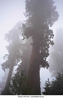
Sequoia National Forest is located in the southern Sierra Nevada mountains of California. The U.S. National Forest is named for the majestic Giant Sequoia trees which populate 38 distinct groves within the boundaries of the forest.

Winston-Salem Memorial Coliseum was a multi-purpose arena in Winston-Salem, North Carolina. The arena, which opened in 1955, held 8,500 people and was eventually replaced by the Lawrence Joel Veterans Memorial Coliseum in 1989. It was home to the Wake Forest Demon Deacons men's basketball team from 1956 to 1989, though from 1959 onward the Deacons played a large number of their games at the Greensboro Coliseum as well.

Stewarts Creek Township is one of fifteen townships in Surry County, North Carolina. The township had a population of 5,653 according to the 2000 census.
Big Creek Township is one of nine townships in Stokes County, North Carolina, United States. The township had a population of 1,984 according to the 2000 census.

Peters Creek Township is one of nine townships in Stokes County, North Carolina, United States. The township had a population of 2,053 according to the 2000 census.
Hawks State Forest is a state forest in Carroll County, Virginia. It offers watershed protection and wildlife habitat.
Niday Place State Forest is a Virginia state forest located on John's Creek Mountain in Craig County. 254 acres (1.03 km2) in size, it is a wildlife sanctuary and is used as an outdoor laboratory; it contains mainly mountain hardwoods. It is managed by Appomattox-Buckingham and Cumberland State Forests. Land for the state forest was donated by Anne H. Cutler of Williamsburg, Virginia.
Fernwood State Forest is a state forest in Jefferson County, Ohio, United States.

Carroll County is a United States county located in the southwestern part of the Commonwealth of Virginia. Roughly one fifth of the county lies in the Virginia Piedmont region, while the rest is part of the Appalachian Mountains. The Carroll county seat and largest town is Hillsville.
Allisonia is a census-designated place (CDP) in Pulaski County, Virginia, United States. The population as of the 2010 Census was 117.
Reed Junction is an unincorporated community in Pulaski County, in the U.S. state of Virginia.
Lumpkin Forest is an unincorporated community in Pittsylvania County, in the U.S. state of Virginia.
Pittsville is an unincorporated community in Pittsylvania County, in the U.S. state of Virginia.
Kate's Mountain, south of White Sulphur Springs in Greenbrier County, West Virginia, was named for Catherine "Kate" Carpenter, who in September 1756 took refuge with her child on the mountain's peak during an Indian attack in which her husband Nicholas Carpenter was killed near Fort Dinwiddie in the vicinity of White Sulphur Springs, West Virginia. Kate's Mountain is the highest of the peaks in Greenbrier State Forest at 3,280 feet. Kate's Mountain was the inspiration for the 19th Century romantic poem The Mystic Circle of Kate's Mountain, first published in fragmentary form in 1860 and published in its entirety in 1895. Kate's Mountain is the type location for Kate’s Mountain Clover, Trifolium virginicum J.K. Small, 1892, the symbol of the West Virginia Native Plant Society.


