Cumberland Gap Tunnel

Last updated
Cumberland Gap Tunnel
Cumberland Gap Tunnel.jpg
Overview
Location Tennessee-Kentucky state line
Coordinates 36°35′53″N83°40′34″W / 36.59806°N 83.67611°W / 36.59806; -83.67611
RouteUS 25E.svg US 25E and Tennessee 32.svg SR 32
Crosses Cumberland Gap
Start Cumberland Gap, Tennessee
End Middlesboro, Kentucky
Operation
Work begunJune 21, 1991;32 years ago (1991-06-21)
OpenedOctober 18, 1996;26 years ago (1996-10-18)
OperatorCumberland Gap Tunnel Authority
Trafficautomotive
Character Controlled-access
Tollnone
Vehicles per day32,000 [1]
Technical
Design engineer
Length4,600 feet (1,400 m) [1]
No. of lanes 4
Tunnel clearance 16.5 ft (5.03 m)
Width32 ft (9.75 m)
Route map
Cumberland Gap Tunnel
Approach from Cumberland Gap, Tennessee CumberlandGap.jpg
Approach from Cumberland Gap, Tennessee
Tunnel interior Cumberland gap tunnel interior.JPG
Tunnel interior

The Cumberland Gap Tunnel is a dual-bore, four lane vehicular tunnel that carries U.S. Route 25E under Cumberland Gap National Historical Park near the intersection of Kentucky, Tennessee, and Virginia. The tunnel consists of two separate bores which carry four lanes of traffic between Cumberland Gap, Tennessee and Middlesboro, Kentucky. It is one of only two mountain vehicular tunnels in the United States that cross a state line, the other being the East River Mountain Tunnel on Interstate 77 and U.S. Route 52 between Virginia and West Virginia. The tunnel opened to traffic in 1996 and replaced a section of highway through the Cumberland Gap that had earned the nickname "Massacre Mountain" due to its hazardous design and high rate of traffic accidents.

Contents

Description

The tunnels are located in the Cumberland Mountains, a subrange of the Appalachian Plateau, which is, in turn, a subrange of the Appalachian Mountains. The Cumberland Gap, a mountain pass that was important in American colonial history, is located at its closest point, about 0.4 miles (0.64 km) northeast of the tunnels. The tri-point of Tennessee, Kentucky, and Virginia is located about 0.15 miles (0.24 km) northeast of the tunnel, between the tunnel and the Cumberland Gap. Less than 12 mile (0.80 km) past the southern portal of the tunnel is a parclo interchange with the western terminus of U.S. Route 58 (US 58), and the route crosses a railroad about 200 feet (61 m) before entering the southern portal. Upon exiting the northern portal, the highway passes underneath the same railroad about 0.2 miles (0.32 km) later, before reaching a parclo interchange with a connector road to the park's visitor center.

The tunnels consist of two tubes, each 4,600 feet (1,400 m) long. Each tube is 32 feet (9.8 m) wide and 16.5 feet (5.0 m) high, and carries two lanes of traffic. Cross-passages are located between the tubes every 300 feet (91 m), and contain fire extinguishers and phones. Ventilation fans are located on the roofs of each tunnel every 600 feet (180 m). An "illumination zone" is included at each portal to allow drivers' vision to adjust to the lower light level in the tunnel. The speed limit in the tunnel is 45 miles per hour (72 km/h). Lane changes are prohibited inside the tunnel. Trucks carrying Class 1 hazardous cargo (i.e., explosives) are prohibited from using the tunnels, while other hazardous cargo and wide loads are directed to pull off into an area in front of each portal and sent through one at a time with an escort. The tunnels are equipped throughout their entire length and at each approach with closed circuit television (CCTV) cameras, which are connected to monitors in the control rooms. The tunnels also contain a Supervisory Control and Data Acquisition System (SCADA), which is connected to the ventilation fans, carbon monoxide detectors, smoke detectors, and linear heat detectors in each tube. This system is designed to alert the control room operators of any hazards or mechanical malfunctions within the tunnel. Operators also control electronic message boards located inside the tunnels and along the approaches to the tunnels. Identical control rooms are located above each portal, which are staffed by operators 24 hours a day. Administrative offices and training rooms are also located here.

The tunnels are operated and maintained by Tunnel Management, Inc., which uses the trade name Cumberland Gap Tunnel Authority (CGTA). The authority consists of 37 full-time employees, and is divided into an Administrative Team, Mechanical and Electrical Team, and four Operations Teams, the latter of which operate the tunnels. The authority also operates an emergency medical service, fire department, and towing crew.

History

In 1908, The federal government built a macadamized road between Middlesboro, Kentucky to Cumberland Gap, Tennessee called Government Pike that partially passed through the gap. [2] In 1916, the states of Tennessee, Virginia, and Kentucky constructed a road through the Cumberland Gap that connected to the Government Pike. [2] This road, along with part of the Government Pike, became part of US 25E and the Dixie Highway system, and contained several sharp curves. [2] As a result, the 2.3 miles (3.7 km) road through the Cumberland Gap quickly developed a reputation for having a high rate of traffic accidents, earning the nickname "Massacre Mountain". [3] Multiple safety improvements were made to the route in the 1960s. A tunnel to replace the highway through the Gap was first proposed by the National Park Service in 1956. Several studies conducted over the next decade recommended a tunnel be constructed. During this time it was decided that widening the existing surface road to four lanes would adversely affect the historically sensitive areas in the park, making a tunnel the only viable choice.

The first $1.1 million for the construction of the tunnel was allocated by Congress in 1979. That same year, geologists examined the rock types at the proposed location for the tunnels. A contract for initial construction activities was awarded on November 20, 1984, but the Administration of President Ronald Reagan abruptly issued an order to halt the project on December 14, 1984, reportedly in an effort to reduce the Federal budget deficit. [4] After pressure from lawmakers in the area, including Representative Hal Rogers, whose district included the Kentucky portion of the tunnel, Interior Secretary Donald P. Hodel announced on May 15, 1985, that the project would proceed. [5]

Between December 1985 and December 1986, a pilot tunnel 4,100 feet (1,200 m) long, 10 feet (3.0 m) wide, and 10 feet (3.0 m) high was drilled. [6] [7] At this time, the tunnels were expected to be open to traffic by 1991, and cost about $160 million (equivalent to $347 million in 2021 [8] ). [9] During this excavation, workers discovered thick clay infillings, limestone formations, caves, multiple underground springs and streams, and a lake within the mountain, which caused a leakage of 450 US gallons (1,700 L) of water per minute into the tunnels would later pose a challenge to construction, and increase the cost of the project. To eliminate leakage into the tunnel, the tubes were lined with a thick PVC layer.

Construction was administered by the Eastern Federal Lands Highway Division of the Federal Highway Administration for the National Park Service, with funding provided by both agencies as well as the states of Kentucky and Tennessee. While the project was in the planning phases, Kentucky and Tennessee both began widening their portions of U.S. 25E leading to Cumberland Gap to four lanes. Construction inspection, project management and engineering services were administered by Vaughn & Melton Consulting Engineers.

Construction of the actual tubes began on June 21, 1991. Excavation continued simultaneously from both sides, and the tunnels were joined on July 9, 1992. The tunnels opened to traffic on October 18, 1996. [10] The overall construction cost, including the four-lane approach roads at both portals, was $280 million (equivalent to $453 million in 2021 [8] ).

The southbound tunnel was briefly closed in 20062007 for construction. In 2012, the tunnel was partially closed to replace some of the crushed limestone road base with granite.

See also

Related Research Articles

<span class="mw-page-title-main">Interstate 24</span> Interstate Highway in Illinois, Kentucky, Tennessee, and Georgia

Interstate 24 (I-24) is an Interstate Highway in the Midwestern and Southeastern United States. It runs diagonally from I-57, 10 miles (16 km) south of Marion, Illinois, to Chattanooga, Tennessee, at I-75. It travels through Illinois, Kentucky, Tennessee, and Georgia. As an even-numbered Interstate, it is signed as an east–west route, though the route follows a more southeast–northwest routing, passing through Nashville, Tennessee. The numbering deviates from the standard Interstate Highway System grid, lying further north than its number would indicate west of Nashville. The short segment within Georgia bears the unsigned designation State Route 409 (SR 409).

<span class="mw-page-title-main">Middlesboro, Kentucky</span> City in Kentucky, United States

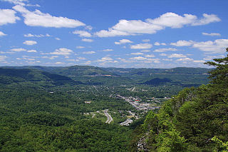
Middlesboro is a home rule-class city in Bell County, Kentucky, United States. The population was 10,334 at the 2010 U.S. census, while its micropolitan area had a population of 69,060.

<span class="mw-page-title-main">U.S. Route 25</span> Highway in the United States

U.S. Route 25 is a north–south United States Highway that runs for 750 miles (1,210 km) in the southern and midwestern US. Its southern terminus is in Brunswick, Georgia, from where it proceeds mostly due north, passing through the cities of Augusta, Georgia, Greenville, South Carolina, and Asheville, North Carolina, before dividing into two branches, known as U.S. Route 25W and U.S. Route 25E between Newport, Tennessee, and North Corbin, Kentucky. After passing through Richmond and Lexington, Kentucky, it reaches its northern terminus at Ohio state line in Covington, Kentucky. The route is an important crossing of the Appalachian Mountains, and it is covered by three of the corridors of the Appalachian Development Highway System. When the highway was originally established in 1926, the route extended from North Augusta, South Carolina to Port Huron, Michigan. The southern end was extended to its current terminus in 1936, while the northern end was truncated in 1974.

<span class="mw-page-title-main">U.S. Route 58</span> Highway in the United States

U.S. Route 58 is an east–west U.S. Highway that runs for 508 miles (818 km) from U.S. Route 25E just northwest of Harrogate, Tennessee, to U.S. Route 60 in Virginia Beach, Virginia. Until 1996, when the Cumberland Gap Tunnel opened, US 58 ran only inside the commonwealth of Virginia. It was then extended southwest along a short piece of former US 25E, which no longer enters Virginia, to end at the new alignment in Tennessee. For most of its alignment, it closely parallels Virginia's southern border with North Carolina.

<span class="mw-page-title-main">Cumberland Gap National Historical Park</span> Historic area in Kentucky, Tennessee, and Virginia, U.S.

The Cumberland Gap National Historical Park is a United States National Historical Park located at the border between Kentucky, Tennessee, and Virginia, centered on the Cumberland Gap, a natural break in the Appalachian Mountains.

<span class="mw-page-title-main">Wilderness Road</span> Historic highway in Kentucky, US

The Wilderness Road was one of two principal routes used by colonial and early national era settlers to reach Kentucky from the East. Although this road goes through the Cumberland Gap into southern Kentucky and northern Tennessee, the other is sometimes called the "Cumberland Road" because it started in Fort Cumberland in Maryland. Despite Kentucky Senator Henry Clay's advocacy of this route, early in the 19th century, the northern route was selected for the National Road, connecting near Washington, Pennsylvania into the Ohio Valley of northern Kentucky and Ohio.

<span class="mw-page-title-main">Cumberland Gap</span> Narrow pass through the Cumberland Mountains

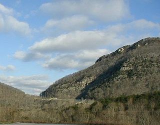
The Cumberland Gap is a pass in the eastern United States through the long ridge of the Cumberland Mountains, within the Appalachian Mountains and near the tripoint of Kentucky, Virginia, and Tennessee. At an elevation of 1,631 feet (497 m) above sea level, it is famous in American colonial history for its role as a key passageway through the lower central Appalachians.

<span class="mw-page-title-main">Bean Station, Tennessee</span> Lakeside town in Grainger and Hawkins counties, Tennessee

Bean Station is a town in Grainger and Hawkins counties in the state of Tennessee, United States. As of the 2020 census, the population was 2,967.

<span class="mw-page-title-main">Appalachian Development Highway System</span> Series of highway corridors in the Appalachia region of the eastern United States

The Appalachian Development Highway System (ADHS) is a series of highway corridors in the Appalachia region of the eastern United States. The routes are designed as local and regional routes for improving economic development in the historically isolated region. It was established as part of the Appalachian Regional Development Act of 1965, and has been repeatedly supplemented by various federal and state legislative and regulatory actions. The system consists of a mixture of state, U.S., and Interstate routes. The routes are formally designated as "corridors" and assigned a letter. Signage of these corridors varies from place to place, but where signed are often done so with a distinctive blue-colored sign.

The Great Smoky Mountains Parkway is a highway that travels 23.4 miles (37.7 km) between the Great Smoky Mountains National Park and Interstate 40 (I-40) in Kodak, Tennessee, in East Tennessee. It serves as the main thoroughfare for Gatlinburg, Pigeon Forge, and Sevierville, and includes a 4.3-mile (6.9 km) spur of the Foothills Parkway. It is composed of sections of a number of numbered highways, including U.S. Route 441 (US 441) and US 321 and State Route 66 (SR 66) and SR 448.

<span class="mw-page-title-main">U.S. Route 11W</span> Suffixed section of U.S. Highway in Tennessee and Virginia in the United States

U.S. Route 11W (US 11W) is the western branch of US 11 from the twin cities of Bristol, Tennessee/Bristol, Virginia, where US 11 splits into US 11E and US 11W, to Knoxville, Tennessee, where the two highways rejoin. The highway serves the Appalachia region's Ridge-and-Valley section of East Tennessee, bounded by the Clinch Mountain ridge to the north and the Holston River to the south. US 11W from Bristol to Bean Station and Blaine to Knoxville are designated as part of the National Highway System.

<span class="mw-page-title-main">U.S. Route 25E</span> Highway in Tennessee and Kentucky, United States

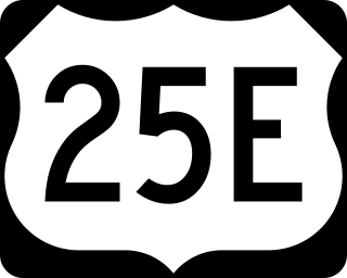
U.S. Route 25E (US 25E) is the eastern branch of US 25 from Newport, Tennessee, where US 25 splits into US 25E and US 25W, to North Corbin, Kentucky, where the two highways rejoin. The highway, however, continues as US 25E for roughly two miles (3.2 km) until it joins Interstate 75 (I-75) in the Laurel County community of North Corbin at exit 29. The highway serves the Appalachia regions of Kentucky's Cumberland Plateau and the Ridge-and-Valley section of East Tennessee, including the urbanized areas of Corbin and Middlesboro in Kentucky and Morristown in Tennessee.

<span class="mw-page-title-main">Clinch Mountain</span> Mountain ridge in Tennessee and Virginia, United States

Clinch Mountain is a mountain ridge in the U.S. states of Tennessee and Virginia, lying in the ridge-and-valley section of the Appalachian Mountains. From its southern terminus at Kitts Point, which lies at the intersection of Knox, Union and Grainger counties near Blaine, Tennessee, it runs in a generally east-northeasterly direction to Garden Mountain near Burke's Garden, Virginia. It separates the Clinch River basin, to the north, and the Holston River basin, to the south.

<span class="mw-page-title-main">Interstate 81 in Tennessee</span> Section of Intersate Highway in Tennessee, United States

Interstate 81 (I-81) is part of the Interstate Highway System that runs 855.02 miles (1,376.02 km) northward from Dandridge, Tennessee, to the Thousand Islands Bridge at the Canadian border near Fishers Landing, New York. In Tennessee, I-81 serves the northeastern part of the state, running 75.66 miles (121.76 km) from its southern terminus with I-40 in Dandridge to the Virginia state line in Bristol. The route serves the Tri-Cities region of the state and the eastern parts of the Knoxville metropolitan area, terminating about 35 miles (56 km) east of Knoxville. I-81 bypasses most cities that it serves, instead providing access via interchanges with state and federal routes. It remains in the Ridge-and-Valley topographic region of the Appalachian Mountains for its entire length in Tennessee, and runs in a northeast to southwest direction.

<span class="mw-page-title-main">Cove Lake State Park</span> State park in Tennessee, United States

Cove Lake State Park is a state park in Campbell County, Tennessee, in the southeastern United States. The park consists of 673 acres (2.72 km2) situated around Cove Lake, an impoundment of Cove Creek created by the completion of Caryville Dam in 1936. The park's location is in the town of Caryville and west of Jacksboro.

<span class="mw-page-title-main">Interstate 40 in Tennessee</span> Interstate Highway in Tennessee, United States

Interstate 40 (I-40) is part of the Interstate Highway System that runs 2,556.61 miles (4,114.46 km) from Barstow, California, to Wilmington, North Carolina. The highway crosses Tennessee from west to east, from the Mississippi River at the Arkansas border to the Blue Ridge Mountains at the North Carolina border. At 455.28 miles (732.70 km), the Tennessee segment of I-40 is the longest of the eight states through which it passes and the state's longest Interstate Highway.

<span class="mw-page-title-main">Interstate 75 in Tennessee</span> Highway in Tennessee

Interstate 75 (I-75) in the US state of Tennessee runs from Chattanooga to Jellico by way of Knoxville. I-75 enters the East Tennessee region from Georgia, following the Tennessee Valley all the way through Knoxville to near Rocky Top, then climbs into the Cumberland Mountains before crossing over into Kentucky at Jellico.

Cumberland Gap is a mountain pass in the Appalachian Mountains at the juncture of the U.S. states of Tennessee, Kentucky, and Virginia.

<span class="mw-page-title-main">Tennessee State Route 32</span> State unsigned highway in Tennessee

State Route 32 is a state highway in East Tennessee. For most of its route, it is an unsigned companion route concurrent with U.S. Route 25E. The highway stretches 89 miles from the North Carolina state line to the Tennessee-Kentucky state line near the town of Cumberland Gap.

References

  1. 1 2 "Cumberland Gap Highway Tunnel Celebrates 15th Anniversary". Cumberland Gap National Historical Park . National Park Service. October 11, 2011. Retrieved May 30, 2021.
  2. 1 2 3 "The Cumberland Gap - Back In Time". fhwa.gov. Federal Highway Administration. June 27, 2017. Retrieved May 31, 2021.
  3. Bergstrom, Bill (August 19, 1984). "$150 million tunnel planned to replace Cumberland Gap's 'massacre mountain'". The Kentucky Advocate. Danville, Kentucky. Associated Press. p. 16. Retrieved May 31, 2021 via Newspapers.com.
  4. York, Michael (December 15, 1984). "Cumberland Gap tunnel project suspended". Lexington Herald-Leader. p. B1, B2 . Retrieved January 30, 2021 via Newspapers.com.
  5. Bergstrom (May 16, 1985). "Cumberland Gap tunnel back on track". Inquirer-Messenger. Owensboro, Kentucky. Associated Press. p. 2C. Retrieved January 30, 2021 via Newspapers.com.
  6. Jones Lewis, Judy (December 13, 1986). "Cumberland Gap tunnel: There's light at the end". Lexington Herald-Leader. p. A1. Retrieved January 30, 2021 via Newspapers.com.
  7. Bergstrom, Bill (February 9, 1986). "Project to put a hole in the Gap gets under way". Messenger-Inquirer. Owensboro, Kentucky. Associated Press. p. 8C. Retrieved January 30, 2021 via Newspapers.com.
  8. 1 2 Johnston, Louis; Williamson, Samuel H. (2023). "What Was the U.S. GDP Then?". MeasuringWorth. Retrieved January 1, 2023. United States Gross Domestic Product deflator figures follow the Measuring Worth series.
  9. Jones Lewis, Judy (July 13, 1986). "Workers tunneling into the unknown". Lexington Herald-Leader. p. A1, A16 . Retrieved January 30, 2021 via Newspapers.com.
  10. Gerth, Joseph (October 19, 1996). "Gap tunnel opens amid high hopes". The Courier-Journal. Louisville. p. A1, A4 . Retrieved January 30, 2021 via Newspapers.com.