
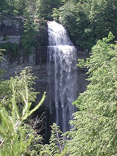
Cumberland Falls, sometimes called the Little Niagara, the Niagara of the South, or the Great Falls, is a waterfall on the Cumberland River in southeastern Kentucky. Spanning the river at the border of McCreary and Whitley counties, the waterfall is the central feature of Cumberland Falls State Resort Park and is part of the Office of Kentucky Nature Preserves designated Wild River System.

Letcher County is a county located in the U.S. state of Kentucky. As of the 2010 census, the population was 24,519. Its county seat is Whitesburg. The county, founded in 1842, is named for Robert P. Letcher, Governor of Kentucky from 1840 to 1844.

Williamsburg is a home rule-class city in and the county seat of Whitley County, on the southeastern border of Kentucky, United States. The population was 5,245 at the 2010 census. Developed along the Cumberland River, the city was founded in 1818 and named after William Whitley.

The Daniel Boone National Forest is a national forest in Kentucky. Established in 1937, it includes 708,000 acres (287,000 ha) of federally owned land within a 2,100,000 acres (850,000 ha) proclamation boundary. The name of the forest was changed in 1966 in honor of the explorer Daniel Boone.

The Cumberland Gap National Historical Park is a United States National Historical Park located at the border between Kentucky, Tennessee, and Virginia, centered on the Cumberland Gap, a natural break in the Appalachian Mountains.
The Cumberland Gap is a pass through the long ridge of the Cumberland Mountains, within the Appalachian Mountains, near the junction of the U.S. states of Kentucky, Virginia, and Tennessee. It is famous in American colonial history for its role as a key passageway through the lower central Appalachians.
Fall Creek Falls State Resort Park is a state park in Van Buren and Bledsoe counties, in the U.S. state of Tennessee. The over 26,000-acre (110 km2) park is centered on the upper Cane Creek Gorge, an area known for its unique geological formations and scenic waterfalls. The park's namesake is the 256-foot (78 m) Fall Creek Falls, the highest free-fall waterfall east of the Mississippi River.

Rock Island State Park is a state park in Warren County and White County, Tennessee, located in the Southeastern United States. The park is named after the community of Rock Island, Tennessee, which in turn received its name from an island on the Caney Fork upstream from the Collins River confluence and Great Falls Dam. Rock Island State Park is centered on a peninsula created by the confluence of these two rivers and extends downstream to the headwaters of Center Hill Lake.

Falls of the Ohio State Park is a state park in the U.S. state of Indiana. It is located on the banks of the Ohio River at Clarksville, Indiana, across from Louisville, Kentucky. The park is part of the Falls of the Ohio National Wildlife Conservation Area. The exposed fossil beds of the Jeffersonville Limestone dated from the Devonian period are the main feature of the park. The Falls was the site where Lewis & Clark met for the Lewis and Clark Expedition.

Frozen Head State Park and Natural Area is a state park in Morgan County, Tennessee, in the southeastern United States. The park, situated in the Crab Orchard Mountains between the city of Wartburg and the community of Petros, contains some of the highest mountains in Tennessee west of the Blue Ridge.

Cumberland Falls State Resort Park is a park located just southwest of Corbin, Kentucky and is contained entirely within the Daniel Boone National Forest. The park encompasses 1,657 acres (671 ha) and is named for its major feature, 68-foot-tall (21 m) Cumberland Falls. The falls are one of the few places in the western hemisphere where a moonbow can frequently be seen on nights with a full moon. The park is also the home of 44-foot (13 m) Eagle Falls. The section of the Cumberland River that includes the falls was designated a Kentucky Wild River by the Kentucky General Assembly through the Office of Kentucky Nature Preserves' Wild Rivers System. The forest in the park is also a dedicated State Nature Preserve.
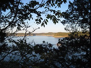
Lake Cumberland State Resort Park is a state park located on the northern shore of Lake Cumberland near Jamestown, Kentucky in Russell County. The park itself encompasses 3,117 acres (1,261 ha), while the lake, its major feature, covers approximately 50,250 acres (20,340 ha).
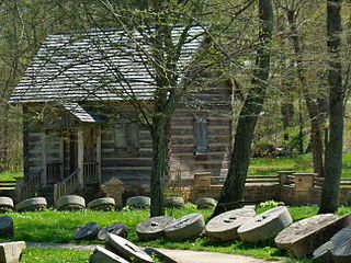
Levi Jackson Wilderness Road Park is a former state park located just south of London, Kentucky in Laurel County. It is now a city park under the auspices of the city of London, KY. The park encompasses 896 acres (363 ha) and includes a section of the Wilderness Road that early settlers used to reach Kentucky. The park is named for Levi Jackson, an early Kentucky pioneer. It serves as both a recreational and historic park.

Pine Mountain State Resort Park is a Kentucky state park located in Bell County, southeastern Kentucky, United States. Located on part of the Pine Mountain ridge in the Appalachians, the park opened in 1924 as Kentucky's first state park.

Cove Lake State Park is a state park in Campbell County, Tennessee, in the southeastern United States. The park consists of 673 acres (2.72 km2) situated around Cove Lake, an impoundment of Cove Creek created by the completion of Caryville Dam in 1936. The park's location is adjacent to the town of Caryville and just west of Jacksboro.

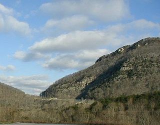
Pine Mountain is a ridge in the Appalachian Mountains running through Kentucky, Virginia and Tennessee. It extends about 125 miles from near Pioneer, Tennessee, to a location near Elkhorn City, Kentucky. Birch Knob, the highest point, is 3,273 feet above sea level and is located on the Kentucky-Virginia border. It has long been a barrier to transportation, as the Cumberland River at Pineville, Kentucky is one of only two waterways that pass through the entire ridge. The other is the Clear Fork near Jellico, Tennessee.

Ozone Falls State Natural Area is a state natural area in Cumberland County, Tennessee in the southeastern United States. It consists of 43 acres (0.17 km2) centered on Ozone Falls, a 110-foot (34 m) plunge waterfall, and its immediate gorge along Fall Creek. Because of its picturesque beauty and easy access, Disney selected Ozone Falls for scenes for their live-action film "Rudyard Kipling's The Jungle Book". The area is managed by the Tennessee Department of Environment and Conservation and maintained by Cumberland Mountain State Park. It is also part of Cumberland Trail State Park.

Bledsoe Creek State Park is a state park in Sumner County, Tennessee, in the southeastern United States. The park consists of 169 acres (0.68 km2) managed by the Tennessee Department of Environment and Conservation. The park spans much of the west shore of the Bledsoe Creek embayment of Old Hickory Lake, an impoundment of the Cumberland River created with the completion of Old Hickory Dam by the U.S. Army Corps of Engineers in 1954.

Laurel-Snow State Natural Area is a Tennessee Class II Natural-Scientific State Natural Area located in Rhea County, Tennessee, near Dayton, on Walden Ridge of the Cumberland Plateau. The 2,259-acre (9.14 km2) area is owned by the State of Tennessee and managed by the Tennessee Department of Environment and Conservation. It is a component of the Cumberland Trail, a linear park.


