Harlan County is a county located in southeastern Kentucky. As of the 2020 census, the population was 26,831. Its county seat is Harlan. It is classified as a moist county—one in which alcohol sales are prohibited, but containing a "wet" city—in this case Cumberland, where package alcohol sales are allowed. In the city of Harlan, restaurants seating 100+ may serve alcoholic beverages.
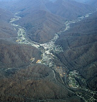
Evarts is a home rule-class city in Harlan County, Kentucky, in the United States. The post office was opened on February 9, 1855, and named for one of the area's pioneer families. The city was formally incorporated by the state assembly in 1921. The population was 962 at the 2010 census.

A trailhead is the point at which a trail begins, where the trail is often intended for hiking, biking, horseback riding, or off-road vehicles. Modern trailheads often contain restrooms, maps, signposts, and distribution centers for informational brochures about the trail and its features and parking areas for vehicles and trailers. The United States Access Board states, "A trailhead is defined as an outdoor space that is designated by an entity responsible for administering or maintaining a trail to serve as an access point to the trail." The intersection of two trails is a trail junction and does not constitute a trailhead.

The Cleveland National Forest encompasses 460,000 acres/720 sq mi (1,900 km2) of inland montane regions—approx. 60 miles from the Pacific Ocean—within the counties of San Diego, Riverside, and Orange, California. The landscape varies somewhat, with mostly chaparral canyons, arroyos and high desert, but dotted with meadows and oak and conifer forests. Near water sources, riparian environments and perennial aquatic plants attract native and migratory wildlife, such as at San Diego’s man-made Lake Cuyamaca. A generally warm and dry, inland-Mediterranean climate prevails over the forest, with the cooler months producing morning frost and snowfall. It is the southernmost U.S. National Forest of California. The area is administered by the U.S. Forest Service, a government agency within the United States Department of Agriculture, and is locally overseen by the Descanso, Palomar and Trabuco Ranger Districts.
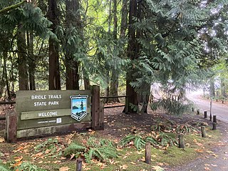
Bridle Trails State Park is a 489-acre (198 ha) state park in the Bridle Trails neighborhood in an unincorporated part of the Eastside area of King County, Washington. Established in 1932 and developed in 1933 by the Civil Works Administration, primary features of the park include a forested trail system shared by pedestrians and equestrians and an outdoor arena used for equestrian purposes.

Chugach State Park covers 495,204 acres covering a hilly region immediately east of Anchorage, in south-central Alaska.

The Slickrock Trail, is a popular mountain biking destination in Grand County, Utah, United States, a few miles northeast of the city of Moab.
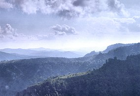
Kingdom Come State Park is a part of Kentucky's state park system in Harlan County atop Pine Mountain near the city of Cumberland. It was named after the 1903 best-selling novel The Little Shepherd of Kingdom Come by native Kentuckian John Fox, Jr. Features of the park include Raven Rock, Log Rock, and a 3.5-acre (1.4 ha) mountain lake. The section of the park is also a legally dedicated state nature preserve by the Office of Kentucky Nature Preserves.

Lincoln National Forest is a unit of the U.S. Forest Service located in southern New Mexico. The Lincoln National Forest covers an extensive 1.1 million acres in southeastern New Mexico. Established by Presidential Proclamation in 1902 as the Lincoln Forest Reserve, the 1,103,897 acres (4,467.31 km2) forest begins near the Texas border and contains lands in parts of Chaves, Eddy, Lincoln, and Otero counties. The Lincoln National Forest is home to three major mountain ranges: Sacramento, Guadalupe and Capitan. The three Ranger Districts within the forest contain all or part of a total of four mountain ranges, and include a variety of different environmental areas, from desert to heavily forested mountains and sub-alpine grasslands. Clean air, water, and soil are necessary elements that the National Forests contribute to the environment. Established to balance conservation, resource management, and recreation, the lands of the Lincoln National Forest include important local timber resources, protected wilderness areas, and popular recreation and winter sports areas. The forest headquarters is located in Alamogordo, N.M. with local offices in Carlsbad, Cloudcroft, and Ruidoso.

The Sam Houston National Forest, one of four National Forests in Texas, is located 50 miles north of Houston. The forest is administered together with the other three United States National Forests and two National Grasslands located entirely in Texas, from common offices in Lufkin, Texas. The units include Angelina, Davy Crockett, Sabine, and Sam Houston National Forests, plus Caddo National Grassland and Lyndon B. Johnson National Grassland. There are local ranger district offices located in New Waverly. It is located in portions of three Texas counties including Montgomery, San Jacinto, and Walker.
The Hatfield–McCoy Trails (HMT) is a trail system popular for its recreational trails for ATVs, UTVs, and dirt bikes, but the trails are also open to hikers, mountain bikers, and horse riders. HMT is located in West Virginia's south west counties of Boone, Kanawha, Lincoln, Logan, McDowell, Mercer, Mingo, Wayne, and Wyoming. The HMT trail system is a public–private partnership between private landowners and the Hatfield–McCoy Regional Recreation Authority (HMRRA), a legislatively created quasi-state agency with paid staff and governed by a multi-county board of directors. The HMT project brings in millions of dollars to the West Virginia economy each year.

Jericho Mountain State Park is located in the White Mountains in Berlin, New Hampshire, United States. The park offers trail riding for ATV, UTV, trail bike, and snowmobile enthusiasts, as well as camping, swimming, fishing, canoeing, and picnicking at Jericho Lake.

Buntzen Lake is a 4.8 kilometres (3 mi) long lake in Anmore, British Columbia, Canada, in the Greater Vancouver area. It is named after the first general manager of the B.C. Electric Co., Johannes Buntzen. There is a smaller lake just to the north named McCombe Lake.
Carnegie State Vehicular Recreation Area is a state park unit of California, U.S., providing off-roading opportunities in the Diablo Range. Located in southern Alameda and San Joaquin counties, it is one of eight state vehicular recreation areas (SVRAs) administered by the California Department of Parks and Recreation. With a diversity of terrain ranging from rolling hills to steep canyons, Carnegie has become a popular destination for off-road enthusiasts of all skill levels.

The Backbone Trail is a long-distance trail extending 67.79 miles (109.10 km) across the length of the Santa Monica Mountains in the U.S. state of California. Its western terminus is Point Mugu State Park, and its eastern terminus is Will Rogers State Historic Park in Pacific Palisades. The trail is open to hikers throughout its length. Dogs, mountain bicyclists and horseback riders are only allowed on portions of the trail as posted.

San Benito Mountain is the highest mountain in the Diablo Range of California. The summit is at an elevation of 5,267 feet (1,605 m). The rock is composed of asbestos (chrysotile), an ultramafic rock. It weathers to produce serpentine soils with characteristically low levels of nutrients like nitrogen, phosphorus, potassium, and calcium, and high levels of magnesium and heavy metals including nickel and chromium. This means little vegetation grows in the area though there are some plants that only grow on such soils like the local endemic San Benito evening primrose. The Clear Creek Management Area includes the San Benito Mountain Research Natural Area, recognized for its unique pine and incense cedar forest assemblage. The Mediterranean climate is punctuated by cool, wet winters and hot, dry summers.

The Snow Mountain Wilderness is a 60,076-acre (243.12 km2) federally designated wilderness area located 65 miles (105 km) north of Santa Rosa, California, USA in the Mendocino National Forest. The U.S. Congress passed the California Wilderness Act of 1984 which created 23 new wilderness areas including Snow Mountain. It lies within the North Coast Range of mountains.

Brace Mountain is the peak of a ridge in the southern Taconic Mountains, near the tripoint of the U.S. states of New York, Connecticut and Massachusetts. Its 2,311-foot (704 m) main summit is located in New York; it is the highest point in that state's Dutchess County.
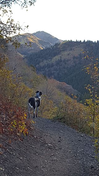
Millcreek Canyon is a canyon in the Wasatch Mountains and part of Millcreek City on the east side of the Salt Lake Valley, Utah. It is a popular recreation area both in the summer and in the winter. It was named by Brigham Young on August 22, 1847, before all of the mills that were built in and below the densely forested canyon. It is home to two restaurants and six Boy Scout Day Camps.
Bull Gap is a 60-acre (240,000 m2) hill climb area located in Michigan and links over 115 miles (185 km) of trails for legal off-road vehicle (ORV) use.