White County is a county located in the U.S. state of Tennessee. As of the 2010 census, the population was 25,841. Its county seat is Sparta.

Grundy County is a county located in the U.S. state of Tennessee. It is located in Middle Tennessee, bordering East Tennessee. As of 2021, the population was 13,622. Its county seat is Altamont. The county is named in honor of Felix Grundy.

Franklin County is a county in the U.S. state of Tennessee. It is located on the eastern boundary of Middle Tennessee in the southern part of the state. As of the 2010 census, the population was 41,052. Its county seat is Winchester. Franklin County is part of the Tullahoma-Manchester, TN Micropolitan Statistical Area.

Tracy City is a town in Grundy County, Tennessee, United States. Incorporated in 1915, the population was 1,481 at the 2010 census. Named after financier Samuel Franklin Tracy, the city developed out of railroad and mining interests after coal was found in 1840. In 2010 the people of Tracy City elected a dead man, Carl Robin Geary, as mayor.

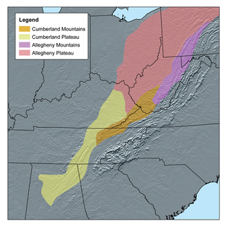
The Cumberland Plateau is the southern part of the Appalachian Plateau in the Appalachian Mountains of the United States. It includes much of eastern Kentucky and Tennessee, and portions of northern Alabama and northwest Georgia. The terms "Allegheny Plateau" and the "Cumberland Plateau" both refer to the dissected plateau lands lying west of the main Appalachian Mountains. The terms stem from historical usage rather than geological difference, so there is no strict dividing line between the two. Two major rivers share the names of the plateaus, with the Allegheny River rising in the Allegheny Plateau and the Cumberland River rising in the Cumberland Plateau in Harlan County, Kentucky.

The Collins River is a 67-mile-long (108 km) stream in the east-central portion of Middle Tennessee in the United States. It is a tributary of the Caney Fork, and is part of the Cumberland, Ohio and Mississippi watersheds. The river drains the scenic Savage Gulf area, located just below the river's source, and empties into Great Falls Lake at Rock Island State Park.

Fall Creek Falls State Resort Park is a state park in Van Buren and Bledsoe counties, in the U.S. state of Tennessee. The over 30,638-acre (123.99 km2) park is centered on the upper Cane Creek Gorge, an area known for its unique geological formations and scenic waterfalls. The park's namesake is the 256-foot (78 m) Fall Creek Falls, the highest free-fall waterfall east of the Mississippi River.

State Route 56 is a 160.6-mile-long (258.5 km) state highway that runs south to north in Middle Tennessee, from the Alabama state line near Sherwood to the Kentucky state line near Red Boiling Springs.

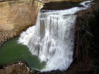
Burgess Falls State Park is a state park and state natural area in Putnam County and White County, Tennessee, located in the southeastern United States. The park is situated around a steep gorge in which the Falling Water River drops 250 feet (76 m) in elevation in less than a mile, culminating in a 136-foot (41 m) cataract waterfall.

Rock Island State Park is a state park in Warren County and White County, Tennessee, located in the Southeastern United States. The park is named after the community of Rock Island, Tennessee, which in turn received its name from an island on the Caney Fork upstream from the Collins River confluence and Great Falls Dam. Rock Island State Park is centered on a peninsula created by the confluence of these two rivers and extends downstream to the headwaters of Center Hill Lake.

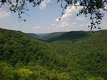
The Justin P. Wilson Cumberland Trail State Park, commonly known as the Cumberland Trail, is a Tennessee hiking trail following a line of ridges and gorges along the eastern escarpment of the Cumberland Plateau and Cumberland Mountains in Tennessee. The trail begins at Cumberland Gap National Historical Park and ends at Chickamauga and Chattanooga National Military Park and Prentice Cooper Wildlife Management Area just outside Chattanooga, Tennessee. The trail travels through 11 Tennessee counties and two time zones.

Frozen Head State Park and Natural Area is a state park in Morgan County, Tennessee, in the southeastern United States. The park, situated in the Crab Orchard Mountains between the city of Wartburg and the community of Petros, contains some of the highest mountains in Tennessee west of the Blue Ridge.

Scott's Gulf is a canyon situated along the Caney Fork River in White County, Tennessee, in the southeastern United States. The canyon stretches for approximately 18 miles (29 km) as the Caney Fork drops from the top of the Cumberland Plateau down to the eastern Highland Rim. This remote section of the river is home to a wilderness area consisting of a largely undisturbed deciduous forest, numerous waterfalls, caves and other geological formations, and Class IV and Class V whitewater rapids.

Ozone Falls State Natural Area is a state natural area in Cumberland County, Tennessee in the southeastern United States. It consists of 43 acres (0.17 km2) centered on Ozone Falls, a 110-foot (34 m) plunge waterfall, and its immediate gorge along Fall Creek. Because of its picturesque beauty and easy access, Disney selected Ozone Falls for scenes for their live-action film "Rudyard Kipling's The Jungle Book". The area is managed by the Tennessee Department of Environment and Conservation and maintained by Cumberland Mountain State Park. It is also part of Cumberland Trail State Park.

Ozone Falls is a waterfall located in Cumberland County, Tennessee in the Ozone Falls State Natural Area and Cumberland Trail State Park. Ozone Falls is situated along Fall Creek, which drains a short section of the Cumberland Plateau between the Crab Orchard Mountains to the west and Walden Ridge to the east. The creek flows down from its source high in the Crab Orchard Mountains for a mile or so before steadying briefly as it enters the community of Ozone. Fall Creek enters the state natural area just after it passes under U.S. Route 70, which runs perpendicular to it. The creek spills over Ozone Falls a few hundred meters south of US-70. The trailhead is located along US-70.
The Window Cliffs State Natural Area covers 275 acres (111 ha) in Putnam County, Tennessee, near Cookeville. The Window Cliffs is the name of a prominent group of natural bridges in a narrow 200-foot-tall (61 m) ridge in the neck of a meander of Cane Creek. The day-use area is only accessible by hiking a 2.7 miles (4.3 km) trail. The Window Cliffs was an acclaimed destination in the nineteenth and early twentieth centuries. The area contains several state-listed endangered plants.

The Fiery Gizzard Trail runs from Tracy City, Tennessee to Foster Falls in Marion County, Tennessee. It is renowned for its beauty and diversity, cited by Backpacker magazine as one of the top 25 hiking trails in the United States. The 12.5-mile (20.1 km) trail offers scenic views, waterfalls, rock formations, and hemlock trees over 200 years old.
The Land Trust for Tennessee is an American non-profit conservation organization working to protect Tennessee's natural, scenic and historic landscapes and sites. Since 1999, The Land Trust has partnered to conserve more than 131,000 acres (530 km2) of land across 65-plus Tennessee counties.

State Route 399 is 10.6-mile-long (17.1 km) east–west state highway in the Cumberland Plateau region of Tennessee. It serves to connect the towns of Gruetli-Laager and Palmer to Cagle and the Savage Gulf State Natural Area portion of South Cumberland State Park.


