Related Research Articles

The Red River Gorge is a canyon system on the Red River in east-central Kentucky. Geologically it is part of the Pottsville Escarpment.

Perry County is a county located in the U.S. state of Tennessee. As of the 2020 census, the population was 8,366, with an average population density of 20.2 persons per square mile it is the least densely populated county in Tennessee. Its county seat and largest town is Linden. It is named after American naval commander and War of 1812 hero Oliver Hazard Perry.
Protected areas of Tasmania consist of protected areas located within Tasmania and its immediate onshore waters, including Macquarie Island. It includes areas of crown land managed by Tasmanian Government agencies as well as private reserves. As of 2016, 52% of Tasmania's land area has some form of reservation classification, the majority is managed by the Tasmania Parks & Wildlife Service. Marine protected areas cover about 7.9% of state waters.

The Little Miami River is a Class I tributary of the Ohio River that flows 111 miles (179 km) through five counties in southwestern Ohio in the United States. The Little Miami joins the Ohio River east of Cincinnati. It forms parts of the borders between Hamilton and Clermont counties and between Hamilton and Warren counties. The Little Miami River is one of 156 American rivers designated by the U.S. Congress or the Secretary of the Interior as a National Wild and Scenic River and lends its name to the adjacent Little Miami Scenic Trail.

The Kentucky River Palisades are a series of steep, scenic gorges and limestone outcroppings that stretch for approximately 100 mi (160 km), along the Kentucky River in central Kentucky in the United States.

Mark Twain National Forest (MTNF) is a U.S. National Forest located in the southern half of Missouri. MTNF was established on September 11, 1939. It is named for author Mark Twain, a Missouri native. The MTNF covers 3,068,800 acres (12,419 km2) of which 1,506,100 acres (6,095 km2) is public owned, 78,000 acres (320 km2) of which are Wilderness, and National Scenic River area. MTNF spans 29 counties and represents 11% of all forested land in Missouri. MTNF is divided into six distinct ranger districts: Ava-Cassville-Willow Springs, Eleven Point, Houston-Rolla, Cedar Creek, Poplar Bluff, Potosi-Fredericktown, and the Salem. The six ranger districts actually comprise nine overall unique tracts of forests. Its headquarters are in Rolla, Missouri.

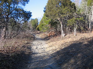
Natural Bridge State Resort Park is a Kentucky state park located in Powell and Wolfe Counties along the Middle Fork of the Red River, adjacent to the Red River Gorge Geologic Area and surrounded by the Daniel Boone National Forest. Its namesake natural bridge is the centerpiece of the park. The natural sandstone arch spans 78 ft (24 m) and is 65 ft (20 m) high. The natural process of weathering formed the arch over millions of years. The park is approximately 2,300 acres (9 km2) of which approximately 1,200 acres (5 km2) is dedicated by the Office of Kentucky Nature Preserves as a nature preserve. In 1981 this land was dedicated into the nature preserves system to protect the ecological communities and rare species habitat. The first federally endangered Virginia big eared bats, Corynorhinus townsendii virginianus, recorded in Kentucky were found at Natural Bridge State Resort Park in the 1950s.

The Chalk Bluffs is a barren chalk escarpment in the northeastern part of the U.S. state of Colorado, stretching from the Wyoming border east of I-25 to near the South Platte River in Logan County and Weld County.
Blue Licks Battlefield State Resort Park is a park located near Mount Olivet, Kentucky in Robertson and Nicholas counties. The park encompasses 148 acres (60 ha) and features a monument commemorating the August 19, 1782 Battle of Blue Licks. The battle was regarded as the final battle of the American Revolutionary War.

In 1999, the Guana Tolomato Matanzas National Estuarine Research Reserve was designated in St. Johns and Flagler counties, Florida as a part of the National Oceanic and Atmospheric Administration (NOAA) National Estuarine Research Reserve (NERR) system. The GTM Research Reserve represents the east Florida sub-region of the Carolinian bioregion. It is one of 30 NERRs in 23 states and one territory. GTM is one of three NERRs in Florida and is administered on behalf of the state by the Florida Department of Environmental Protection's Florida Coastal Office as part of a network that includes forty-one aquatic preserves, three NERRs, a National Marine Sanctuary, the Coral Reef Conservation Program and the Florida Oceans and Coastal Council. Additional interests are held in the research and management of the GTM and connected preserved or conserved lands including:

Perryville Battlefield State Historic Site is a 745-acre (3.01 km2) park near Perryville, Kentucky. The park continues to expand with purchases of parcels by the Office of Kentucky Nature Preserves' Kentucky Heritage Land Conservation Fund and the American Battlefield Trust. An interpretive museum is located near the site where many Confederate soldiers killed in the Battle of Perryville were buried. Monuments, interpretive signage, and cannons also mark notable events during the battle. The site became part of the Kentucky State Park System in 1936.
Big Spring Bog Natural Area Preserve is a 50-acre (20 ha) Natural Area Preserve located in Grayson County, Virginia. The terrain is hilly, and within its borders is Chestnut Creek, a tributary of the New River. The preserve features a rare wetland known as a "cranberry glade".
Johnsons Creek Natural Area Preserve is a 99-acre (40 ha) Natural Area Preserve located in Alleghany County, Virginia. It contains a variety of trees, including ancient red cedars, oaks, and pines, all of which stand on steep shale bluffs overlooking Johnsons Creek.
Pedlar Hills Glades Natural Area Preserve is a 1,036-acre (4.19 km2) Natural Area Preserve located in Montgomery County, Virginia. Rising over the South Fork of the Roanoke River, it supports numerous rare plants and natural communities, including a dolomite barren. Among the species found within the preserve are tall gay-feather and Addison's leatherflower, the latter endemic to Virginia.
Conserving Carolina is a non-profit conservation organization working to preserve water and land resources in Western North Carolina. Conserving Carolina was created in July 2017, from a merger of two previously separate organizations, Carolina Mountain Land Conservancy and Pacolet Area Conservancy. The combined organization maintains a primary office in Hendersonville, NC and a regional office in Columbus, NC.

Heron Pond – Little Black Slough Nature Preserve is a parcel of protected wetland property located in Belknap, Illinois, approximately 5 miles (8 km) southwest of Vienna, in Johnson County. It was designated a National Natural Landmark in 1972. As part of the Cache River basin, it is classified as a wetland of international importance under the Ramsar Convention.
Hemlock Bluffs Nature Preserve is a joint project between the North Carolina state park system and Cary, Wake County, North Carolina in the United States. Located in Cary, it covers approximately 140-acre (0.57 km2) in the Research Triangle region of the state. The state owns 97-acre (0.39 km2) of the preserve, known as Hemlock Bluffs State Natural Area. The Town of Cary owns approximately 42-acre (0.17 km2) of the preserve, and the town leases the state's land for management. The preserve protects a population of Eastern Hemlock trees and other vegetation more typically found further west, in the Appalachian Mountains. The tall, north-facing bluffs of Swift Creek provide conditions similar enough to the mountains to have allowed the plant communities to have survived there since the last ice age.

The Interior Low Plateaus are a physiographic region in eastern United States. It consists of a diverse landscape that extends from north Alabama across central Tennessee and Kentucky into southern Illinois, Indiana, and Ohio. Its natural communities are a matrix of temperate forests, woodlands, and prairies.
The Civil War Trust's Civil War Discovery Trail is a heritage tourism program that links more than 600 U.S. Civil War sites in more than 30 states. The program is one of the White House Millennium Council's sixteen flagship National Millennium Trails. Sites on the trail include battlefields, museums, historic sites, forts and cemeteries.
References
- ↑ Office of Kentucky Nature Preserves
- ↑ The Lexington Herald Leader "How Kentucky selects state nature preserves, December 18, 2020"
- ↑ The Lane Report "Office of Kentucky Nature Preserves Established, June 7, 2018"
- ↑ The Lane Report 2019 State Establishes Abbey of Gethsemane Registered Natural Area
- ↑ ‘Extraordinary property.’ Kentucky adds its first new nature preserve in a decade. Lexington Herald Leader Dec 28, 2020
- ↑ WTVQ October 8 2020 '158 years later Perryville Battlefield Park to grow by hundreds of acres'