
The White River National Wildlife Refuge is a 160,756 acres (650.56 km2) wildlife refuge located in Desha, Monroe, Phillips, and Arkansas counties in the U.S. state of Arkansas. The refuge is managed by the United States Fish and Wildlife Service. White River NWR borders on Cache River National Wildlife Refuge at its northern boundary. In 1974, the White River Sugarberry Natural Area was designated as a National Natural Landmark by the National Park Service.

Aransas National Wildlife Refuge is a 115,324-acre (466.7 km2) protected area situated on the southwest side of San Antonio Bay along the Gulf Coast of the U.S. state of Texas. It is located in parts of Aransas, Refugio, and Calhoun Counties. It is situated on the southwest side of the San Antonio Bay, formed by the mouth of the Guadalupe River. It also includes nearly the entirety of Matagorda Island, a 38-mile barrier island. The Aransas National Wildlife Refuge was established by Executive Order 7784 on 31 December 1937 by President Franklin D. Roosevelt as the Aransas Migratory Waterfowl Refuge as a refuge and breeding ground for migratory birds and other wildlife. Roosevelt issued a proclamation in 1940 changing the name to the Aransas National Wildlife Refuge.

Ridgefield National Wildlife Refuge is a wildlife refuge, one of the national wildlife refuges operated by the United States Fish and Wildlife Service, located in the westernmost part of Clark County, Washington. The refuge protects more than 5,200 acres (2,100 ha) of marshes, grasslands, and woodlands. The refuge was established in 1965, in response to a need to establish vital winter habitat for wintering waterfowl with an emphasis on the dusky Canada goose whose nesting areas in Alaska were severely impacted by the violent earthquake of 1964. Ridgefield NWR is part of the Ridgefield National Wildlife Refuge Complex, headquartered in Ridgefield, Washington, which oversees the management of four refuges in the southwestern part of the state: Ridgefield, and three refuges in the Columbia River Gorge: Franz Lake, Pierce, and Steigerwald Lake. This place was closed in spring of 2019 to cut down Douglas fir and change the trail. In fall of 2020, the construction of a new multi-purpose building began. The new multi-purpose building will be a construction type V-B and consist of a 4,415 square foot single story building with an associated balcony and basement area. The building is being constructed to provide the fish and wildlife staff office space, meeting space, and an area for public visitors including volunteers and conservation partners.
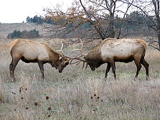
The Charles M. Russell National Wildlife Refuge is a National Wildlife Refuge in the U.S. state of Montana on the Missouri River. The refuge surrounds Fort Peck Reservoir and is 915,814 acres (3,706.17 km2) in size. It is the second-largest National Wildlife Refuge in the lower 48 states of the United States, and the largest in Montana. Created in 1936, it was originally called the Fort Peck Game Range. It was renamed in 1963 after Montana artist Charles M. Russell, a famous painter of the American West. In 1976, the "range" was made a "refuge".
Fort Niobrara National Wildlife Refuge is located in the U.S. state of Nebraska and includes 19,131 acres (77.42 km2). The refuge borders the Niobrara National Scenic River on the west and is managed by the U.S. Fish and Wildlife Service. From 1879 to 1906, the Fort Niobrara Military Reservation was located on what later became refuge lands to house a garrison of the U.S. Cavalry. After the fort was closed, the effort to preserve the region as a wildlife refuge culminated in the creation of the refuge on January 11, 1912. The refuge also manages Valentine and John and Louise Seier National Wildlife Refuges as parts of the Fort Niobrara National Wildlife Refuge Complex.

William L. Finley National Wildlife Refuge is a natural area in the Willamette Valley in Oregon, United States. It was created to provide wintering habitat for dusky Canada geese. Unlike other Canada geese, dusky Canada geese have limited summer and winter ranges. They nest on Alaska's Copper River Delta and winter almost exclusively in the Willamette Valley. Habitat loss, predation, and hunting have caused a decrease in population.
The Theodore Roosevelt National Wildlife Refuge Complex is the largest refuge complex in the state of Mississippi. Over 100,000 acres (400 km2) of refuge lands on seven refuges, including 13,000 acres (53 km2) of refuge-managed Farmers Home Administration lands, provide vital habitat for fish and wildlife in the Delta region.

Baskett Slough National Wildlife Refuge is in northwestern Oregon, 10 miles (16 km) west of Salem in Polk County. The Refuge consists of 1,173 acres (4.75 km²) of cropland, which provide forage for wintering geese, 300 acres (1.2 km²) of forests, 550 acres (2.2 km²) of grasslands, and 500 acres (2.0 km²) of shallow water seasonal wetlands and 35 acres (0.14 km²) of permanent open water. In 1965, Baskett Slough National Wildlife Refuge was created to help ensure some of the original habitat remained for species preservation. The refuge is managed by the U.S. Fish and Wildlife Service, an agency of the U.S. Department of the Interior.

Sherburne National Wildlife Refuge is a National Wildlife Refuge of the United States in Sherburne County, Minnesota. The 30,700-acre (124 km2) refuge protects mixed habitat types including oak savanna, Big Woods, and wetlands. The St. Francis River flows through the eastern side of the park. Over 230 species of birds, 58 species of mammals, and 25 species of reptiles and amphibians have been recorded in the refuge.

Elizabeth Hartwell Mason Neck National Wildlife Refuge is a National Wildlife Refuge of the United States located in Virginia. It is part of the Potomac River National Wildlife Refuge Complex. It is on Mason Neck, a peninsula in the Potomac River that forms part of the shoreline of Belmont Bay. The refuge is adjacent to Mason Neck State Park.
Bayou Cocodrie National Wildlife Refuge was established in 1992 to preserve waterfowl habitat and hardwood forest of the lower Mississippi river. The 13,200-acre (53 km2) refuge is located in Concordia Parish, Louisiana, 10 miles (16 km) southwest of Vidalia, Louisiana. It is named for the state-designated scenic river of Bayou Cocodrie.
The Atchafalaya National Wildlife Refuge is located about 30 miles (48 km) west of Baton Rouge, Louisiana, and one mile (1.6 km) east of Krotz Springs, Louisiana, lies just east of the Atchafalaya River. In 1988 under the administration of Governor Foster the "Atchafalaya Basin Master Plan" was implemented that combined the 11,780-acre (4,770 ha) Sherburne Wildlife Management Area (WMA), the 15,220-acre (6,160 ha) Atchafalaya National Wildlife Refuge, and the 17,000-acre (6,900 ha) U.S. Army Corps of Engineers' Bayou Des Ourses into the Sherburne Complex Wildlife Management Area.
The Great River National Wildlife Refuge protects approximately 11,600 acres (47 km2) along 120 miles (190 km) of the Mississippi River, stretching north of St. Louis, Missouri. Three separate units are located in the floodplain, on both the Illinois and Missouri sides of the river.

Mackay Island National Wildlife Refuge was established in 1960 to provide habitat for migratory waterfowl, primarily the greater snow goose. It is located almost entirely on Knotts Island in the Currituck Sound between Back Bay in Virginia Beach, Virginia and the open sound in North Carolina. Most of the refuge lies within North Carolina but some of it is in Virginia. The refuge is primarily made up of marsh habitat. This area has long been recognized for supporting significant migratory waterfowl populations and sport fishery resources, and is part of the Charles Kuralt Trail.

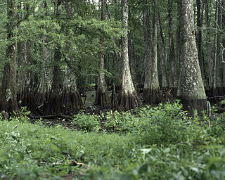
Roanoke River National Wildlife Refuge was established in 1989 to protect and enhance wooded wetlands consisting of bottomland hardwoods and swamps with high waterfowl value along the Roanoke River. The extensive bottomland hardwood habitat of the Roanoke River National Wildlife Refuge is part of what the Nature Conservancy calls "one of the last great places."
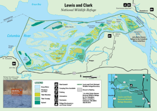
Lewis and Clark National Wildlife Refuge, near the mouth of the Columbia River, provides wintering and resting areas for an estimated 1,000 tundra swans, 5,000 geese, and 30,000 ducks. Other species include shorebirds and bald eagles.
McNary National Wildlife Refuge is a wildlife preserve, one of the national wildlife refuges operated by the United States Fish and Wildlife Service. Extending along the east bank of the Columbia River in southeastern Washington, from the confluence of the Snake River to the mouth of the Walla Walla River, and downstream into Oregon, McNary NWR is located in rural Burbank, but very close to the rapid development of the Tri-Cities. In fact, the refuge meets the definition of an "urban refuge." Few areas in North America support waterfowl populations in the extraordinary numbers found here. There are spectacular concentrations of Canada geese, mallards, and other waterfowl. More than half the mallards in the Pacific Flyway overwinter at some time in this portion of the Columbia River Basin.
The Pierce National Wildlife Refuge is in southwest Washington within the Columbia River Gorge National Scenic Area. It encompasses wetlands and uplands along the north shore of the Columbia River west of the town of North Bonneville. Refuge habitats include wetlands, Columbia River riparian corridor blocks, transitional woodlands from willows to cottonwood/ash to white oak to Douglas fir, improved pastures with some native grasses, and numerous creeks, seeps, and springs.

J. Clark Salyer National Wildlife Refuge is located along the Souris River in Bottineau and McHenry Counties in north-central North Dakota. The refuge of 58,693 acres (237.5 km2) extends from the Manitoba border southward for approximately 45 miles (72 km) in an area which was once Glacial Lake Souris. The area is old lake bottom and has extremely flat topography and a high density of temporary wetlands.


