Souris River
| | This section is empty. You can help by adding to it. (July 2010) |
The US State of North Dakota experienced significant flooding in its major river basins in 2009, following abnormally heavy winter snows atop saturated and frozen ground.
Ground which was already saturated when it froze at the onset of winter, melting snow which could not be absorbed by the frozen ground, [1] and additional precipitation from a rain storm on March 22 and a later snowstorm, are reasons for the serious flooding. [2] [3] Heavy snowfalls fell in the state toward the end of March, adding to the existing snowpack. [4]
Beulah and Hazen were affected by the Knife River and Spring Creek floods. [5] [6] Linton was affected by Big Beaver Creek floods. [7] Barlow, Carrington, Napoleon was affected by overland flooding from heavy snowmelt. Mott was affected by the Cannonball River floods. [8] Wells County, Foster County, and Stutsman County was affected by Pipestem river. Eddy County, Foster County, Stutsman County, La Moure County, and Dickey County was affected by James River.
Explosives had to be used blow up an ice jam on the Missouri River North Bismarck, North Dakota in Double Ditch. [9] It was successful. [10] Flooding would cause problems south of the Bismarck Expressway and west of Washington Street.
| | This section is empty. You can help by adding to it. (July 2010) |
The 2009 Red River flood along the Red River of the North in North Dakota and Minnesota in the United States and Manitoba in Canada brought record flood levels to the Fargo-Moorhead area. The flood is a result of saturated and frozen ground, Spring snowmelt exacerbated by additional rain and snow storms, and virtually flat terrain. Communities along the Red River prepared for more than a week as the U.S. National Weather Service continuously updated the predictions for the city of Fargo, North Dakota with an increasingly higher projected river crest. Originally predicted to reach a level of near 43 feet (13 m) at Fargo by March 29, the river in fact crested at 40.82 feet (12.44 m) at 12:15 a.m. March 28, [11] and started a slow decline. [12] The river continued to rise to the north as the crest moved downstream. [13]
Early predictions for the Wahpeton area saw a predicted level of at least 16 feet (4.9 m). [14] By March 24, the National Weather Service predicted the crest in Wahpeton and Breckenridge not to top 18 feet (5.5 m), below the cities' levees. [15]
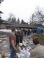

Warnings for the 2009 flood occurred as early as March 9 when the National Weather Service warned that the Fargo-Moorhead area could see a significant flood of between 35 feet (11 m) and 36 feet (11 m). [16] As preparations began for the flooding on March 16, North Dakota Governor John Hoeven declared a statewide disaster in anticipation of flooding across the state. [17] On March 19, the National Weather Service raised the predicted flood level in the Fargo area to between 37 feet (11 m) and 40 feet (12 m). The city began filling sandbags on March 20. [18] In anticipation of a rain and snow storm, the predicted crest level was raised on March 22 to a range from 39 feet (12 m) to 41 feet (12 m). [19]
Volunteers continued preparing sandbags, with 560,000 bags filled by late March 22 out of an expected 1.5 million to 2 million needed. [20] By March 24, residents in Fargo-Moorhead had filled over 1 million sandbags and were attempting to fill a total of 2 million by the 26th. [21] A levee in Georgetown, Minnesota was raised another two feet, and emergency dikes were being built in Fargo, Moorhead, Harwood, Grafton and Richland County. [22] The predicted flood crest was raised again on March 26, changed to between 41 feet (12 m) and 42 feet (13 m) by March 28, with a possibility of 43 feet (13 m).

In addition to the sandbags the construction of the dikes protecting the city has required large amounts of clay. Clay has been brought from several places in and around the city, including the soccer field at Centennial Elementary School and around Discovery Middle School. [23]
At 7:15 P.M. CDT on March 26, 2009, the river exceeded the 1997 crest of 39.57 feet (12.06 m) at Fargo, which was the previous second-highest crest. The projected crest is 24 feet (7.3 m) above flood stage and higher than the record-setting floods in 1997 and 1897. [24]
In the Grand Forks, North Dakota area, flood predictions released February 27 predicted a possibility of a flood crest between 44 feet (13 m) and 46 feet (14 m). The snow storm that struck March 9–10 raised the predicted levels between 47 feet (14 m) and 50 feet (15 m) prompting the city to declare a state of emergency. [25] On March 22 the predicted crest level was changed to 52 feet (16 m). [19]
At 2:30 A.M. CDT, the National Weather Service offices in Grand Forks issued a Flash Flood Warning for extreme east-central Cass County due to a levee breach in Fargo on Linden Avenue. [26] With the river now more than 6 meters (20 feet) above flood stage, there appears to be a growing sense in Fargo that despite best efforts, it may not be possible to build dikes high enough to hold back the river. [27]
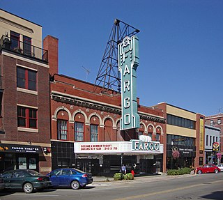
Fargo is a city in and the county seat of Cass County, North Dakota, United States. According to the 2020 census, its population was 125,990, making it the most populous city in the state and the 216th most populous city in the United States. Fargo, along with its twin city of Moorhead, Minnesota, and the adjacent cities of West Fargo, North Dakota and Dilworth, Minnesota, form the core of the Fargo–Moorhead, ND-MN Metropolitan Statistical Area (MSA). The MSA had a population of 248,591 in 2020.

The Red River, also called the Red River of the North to differentiate it from the Red River in the south of the continent, is a river in the north-central United States and central Canada. Originating at the confluence of the Bois de Sioux and Otter Tail rivers between the U.S. states of Minnesota and North Dakota, it flows northward through the Red River Valley, forming most of the border of Minnesota and North Dakota and continuing into Manitoba. It empties into Lake Winnipeg, whose waters join the Nelson River and ultimately flow into Hudson Bay.

The Red River flood of 1997 was a major flood that occurred in April and May 1997 along the Red River of the North in Minnesota, North Dakota, and southern Manitoba. It was the most severe flood of the river since 1826. The flood reached throughout the Red River Valley, affecting the cities of Fargo and Winnipeg, but none so greatly as Grand Forks and East Grand Forks, where floodwaters reached more than 3 miles (4.8 km) inland. They inundated virtually everything in the twin communities. Total damages for the Red River region were US$3.5 billion. The flood was the result of abundant snowfall and extreme temperatures.
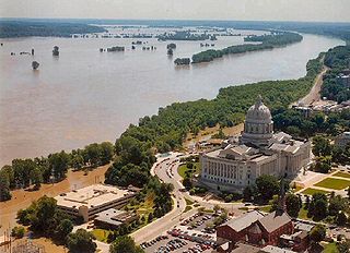
The Great Flood of 1993 was a flood that occurred in the Midwestern United States, along the Mississippi and Missouri rivers and their tributaries, from April to October 1993.

KVLY-TV is a television station in Fargo, North Dakota, United States, affiliated with NBC. It is owned by Gray Television alongside Horace-licensed low-power dual CBS/CW+ affiliate KXJB-LD. The two stations share studios on 21st Avenue South in Fargo; KVLY-TV's transmitter is located near Blanchard. In addition to its main studio in Fargo, KVLY-TV operates a news bureau and sales office in the US Bank building in downtown Grand Forks.

North Dakota's climate is typical of a continental climate with cold winters and warm-hot summers. The state's location in the Upper Midwest allows it to experience some of the widest variety of weather in the United States, and each of the four seasons has its own distinct characteristics. The eastern half of the state has a humid continental climate with warm to hot, somewhat humid summers and cold, windy winters, while the western half has a semi-arid climate with less precipitation and less humidity but similar temperature profiles. The areas east of the Missouri River get slightly colder winters, while those west of the stream get higher summer daytime temperatures. In general, the diurnal temperature difference is prone to be more significant in the west due to higher elevation and less humidity.
The Red River flood of 1997 in the United States was a major flood that occurred in April 1997, along the Red River of the North in North Dakota and Minnesota. The flood reached throughout the Red River Valley, affecting the cities of Fargo, Moorhead, and Winnipeg, while Grand Forks and East Grand Forks received the most damage, where floodwaters reached over 3 miles (5 km) inland, inundating virtually everything in the twin communities. Total damages for the Red River region were US$3.5 billion.

The 2009 Red River flood along the Red River of the North in North Dakota and Minnesota in the United States and Manitoba in Canada brought record flood levels to the Fargo-Moorhead area. The flood was a result of saturated and frozen ground, spring snowmelt exacerbated by additional rain and snow storms, and virtually flat terrain. Communities along the Red River prepared for more than a week as the U.S. National Weather Service continuously updated the predictions for the city of Fargo, North Dakota, with an increasingly higher projected river crest. Originally predicted to reach a level of near 43 feet (13 m) at Fargo by March 29, the river in fact crested at 40.84 feet (12.45 m) at 12:15 a.m. March 28, and started a slow decline. The river continued to rise to the north as the crest moved downstream.

The 1897 Red River flood took place in April 1897, along the Red River resulting in significant damage to the city of Fargo, North Dakota. The conditions which led to the flood of 1897 were similar to the conditions behind the 2009 flood, however the 1897 flood was different in terms of the human response to it. Although the river gauge was not installed on the Red River until 1901, other sources indicate that the crest of the 1897 flood at a site 1.5 miles (2.4 km) downstream from the present Fargo gauge would have been 40.10 ft according to the present datum.

The 2012 United States House of Representatives election in North Dakota was held on Tuesday, November 6, 2012 to elect the U.S. representative from the state's at-large congressional district. The election coincided with the elections of other federal and state offices, including a quadrennial presidential election and an election to the U.S. Senate. A primary election was held on June 12, 2012; a candidate must receive at least 300 votes to appear on the general election ballot in November.
The 2011 Red River flood took place along the Red River of the North in Manitoba in Canada and North Dakota and Minnesota in the United States beginning in April 2011. The flood was, in part, due to high moisture levels in the soil from the previous year, which meant that further accumulation would threaten the flood-prone region. Flood predictors in Winnipeg were worried that a dual crest of both the Assiniboine River and the Red might crest at the city at the same time. Beginning around April 8, 50 homes were evacuated and two more were flooded after an ice jam in St. Andrews, Manitoba caused the river to flood over its banks.

The 2011 Souris/Mouse River flood in Canada and the United States occurred in June and was greater than a hundred-year flooding event for the river. The US Army Corps of Engineers estimated the flood to have a recurrence interval of two to five centuries.

Renwick Dam is a dam in Akra Township, Pembina County, North Dakota, USA, in the northeastern corner of the state.

The 2016 North Dakota gubernatorial election was held on November 8, 2016, to elect the Governor and Lieutenant Governor of North Dakota, concurrently with the 2016 U.S. presidential election, as well as elections to the United States Senate, elections to the United States House of Representatives and various state and local elections. This would have been the first time North Dakotans selected a governor under new voter ID requirements, in which a student ID was insufficient identification to vote, but a court ruling in August 2016 struck the down the provision; the election was held under the 2013 rules.

The Fargo-Moorhead (FM) Area Diversion project, officially known as the Fargo-Moorhead Metropolitan Area Diversion Flood Risk Management Project, is a large, regional flood control infrastructure project on the Red River of the North, which forms the border between North Dakota and Minnesota and flows north to Lake Winnipeg in Manitoba, Canada.
The Red River Valley League was a minor league baseball league that played in the 1897 season. The four–team, Class F level Red River Valley League consisted of teams based in North Dakota and Minnesota. The Red River Valley League played just the 1897 season, before permanently folding. The Moorhead Barmaids were league champions.
The Wahpeton–Breckenridge Methodists were a minor league baseball team based in Wahpeton, North Dakota in partnership with Breckenridge, Minnesota. In 1897, the Methodists played as members of the Class F level Red River Valley League in their only season of play, preceding the 1921 Wahpeton-Breckenridge Twins.

In April 2013, persistent heavy rains caused widespread flooding, primarily impacting the Midwestern and Great Lakes regions. In a span of two days on April 17 and 18, heavy rainfall associated with a slow-moving storm system caused widespread flooding across rivers and areas, where rainfall amounts over 8 inches (200 mm) caused rivers to swell and crest, including the Mississippi River and the Red River, with the latter river dealing with melting ice caps. The Grand River crested to a record level, prompting water rescues and evacuations in Grand Rapids, Michigan. A local state of emergency was declared for the city of Des Plaines, Illinois after the Des Plaines River swelled to 10.92 feet (3,330 mm). The governors of Illinois and Missouri declared state of emergencies, and the Federal Emergency Management Agency declared a federal emergency and a disaster declaration for 46 counties in Illinois. Five fatalities occurred: two each in Illinois and Indiana, with a fifth in Missouri. Three others were injured, all in Illinois.