Related Research Articles

Western Greece Region is one of the thirteen administrative regions of Greece. It comprises the western part of continental Greece and the northwestern part of the Peloponnese peninsula. It occupies an area of 11,336 km2 (4,377 sq mi) and its population is, according to the 2011 census, at 679,796 inhabitants. The capital of the Western Greece is Patras, the third-largest-city in the country with a population of about 280,000 inhabitants. The NUTS 2 code for the region of Western Greece is EL63.

Western Macedonia is one of the thirteen regions of Greece, consisting of the western part of Macedonia. Located in north-western Greece, it is divided into the regional units of Florina, Grevena, Kastoria, and Kozani. With a population of approximately 255,000 people, as of 2021, the region had one of the highest unemployment rates in the European Union.
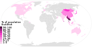
This list of Buddhism by country shows the distribution of the Buddhist religion, practiced by about 535 million people as of the 2010s, representing 7% to 8% of the world's total population.

The Sabaragamuwa Province is one of the nine provinces of Sri Lanka, the first level administrative division of the country. The provinces have existed since the 19th century but did not have any legal status until 1987 when the 13th Amendment to the Constitution of Sri Lanka established provincial councils. The Sabaragamuwa Province contains two districts: Ratnapura and Kegalle. It is named after its former indigenous inhabitants, namely the Sabara, an indic term for hunter-gatherer tribes, a term seldom used in ancient Sri Lanka. Sabaragamuwa University is in Belihuloya.

Memaliaj is a town and a municipality in Gjirokastër County, southern Albania. It was formed at the 2015 local government reform by the merger of the former municipalities Buz, Krahës, Luftinjë, Memaliaj, Memaliaj Fshat and Qesarat, that became municipal units. The seat of the municipality is the town Memaliaj. The total population is 10,657, in a total area of 372.30 square kilometres (143.75 sq mi). The population of the former municipality at the 2011 census was 2,647. It is entirely populated by Albanians, both Muslim Bektashis and Orthodox Christians.

Savar is a city in central Bangladesh, located in Dhaka District in the division of Dhaka. It is the closest city from Dhaka. It is also a part of Greater Dhaka conurbation which forms the Dhaka megacity. About 296,851 people live here which makes this city the 2nd largest in Dhaka District and 11th largest city in Bangladesh.

Rrogozhinë is a town and a municipality in Tirana County, centrally located in the Western Lowlands region of Albania. It was formed at the 2015 local government reform by the merger of the former municipalities Gosë, Kryevidh, Lekaj, Rrogozhinë and Sinaballaj, that became municipal units. The seat of the municipality is the town Rrogozhinë. The total population is 22,148, in a total area of 223.73 km2. The population of the former municipality at the 2011 census was 7,049.

Selenicë is a municipality in Vlorë County, southwestern Albania. It was formed at the 2015 local government reform by the merger of the former municipalities Armen, Brataj, Kotë, Selenicë, Sevaster and Vllahinë, that became municipal units. The seat of the municipality is the town Selenicë.

Roskovec is a town and a municipality in Fier County, south-central Albania. The municipality was formed at the 2015 local government reform by the merger of the former municipalities Kuman, Kurjan, Roskovec and Strum, that became municipal units. The seat of the municipality is the town of Roskovec. The total population is 21,742, in a total area of 118.08 km2. The population of the former municipality at the 2011 census was 4,975.

The Peloponnese Region is a region in southern Greece. It borders Western Greece to the north and Attica to the north-east. The region has an area of about 15,490 square kilometres. It covers most of the Peloponnese peninsula, except for the northwestern subregions of Achaea and Elis which belong to Western Greece and a small portion of the Argolid peninsula that is part of Attica.

Central Greece is one of the thirteen administrative regions of Greece. The region occupies the eastern half of the traditional region of Central Greece, including the island of Euboea. To the south it borders the regions of Attica and the Peloponnese, to the west the region of West Greece and to the north the regions of Thessaly and Epirus. Its capital city is Lamia.

Kamëz is a municipality in Tirana County, Albania. It was formed at the 2015 local government reform by the merger of the former municipalities Kamëz and Paskuqan, that became municipal units. The seat of the municipality is the town Kamëz. The total population is 104,190, in a total area of 37.20 km2. The population of the former municipality at the 2011 census was 66,841.

The Ionian Islands Region is the smallest by area of the thirteen administrative regions of Greece located in the Ionian Sea. It comprises all the Ionian Islands except Kythera, which, although historically part of the island group, was separated and integrated to the Attica Region.
The Population Estimates Program (PEP) is a program of the US Census Bureau that publishes annual population estimates and estimates of birth, death, and international migration rates for people in the United States. In addition to publishing those aggregate estimates for the entire country, the program also publishes those yearly estimates by age, sex, race, and Hispanic origin at the national, state, county and city and town level. By doing so, the Population Estimates Program provides up-to-date information on how the size and distribution of the US population has changed each year since the most recent 10-year US Census.
Nepal conducted a widespread national census in 2011 by the Nepal Central Bureau of Statistics. Working with the 58 municipalities and the 3915 Village Development Committees at a district level, they recorded data from all the municipalities and villages of each district. The data included statistics on population size, households, sex and age distribution, place of birth, residence characteristics, literacy, marital status, religion, language spoken, caste/ethnic group, economically active population, education, number of children, employment status, and occupation.
The Statistical Center of Iran is the main organization for statistics in 6-. It is administered and funded by the Government of Iran.

Dimal is a municipality in Berat County, central Albania. It was formed at the 2015 local government reform by the merger of the former municipalities Cukalat, Kutalli, Poshnjë and Ura Vajgurore, that became municipal units. The seat of the municipality is the town Ura Vajgurore. The total population is 27,295, in a total area of 156.65 km2.
References
- ↑ "EU legislation on the 2011 Population and Housing Censuses - Explanatory Notes". Eurostat. 2011. Archived from the original on 2018-08-07. Retrieved 2019-07-04.