
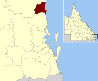
The Shire of Livingstone is a local government area located in the Capricornia region of Central Queensland, Queensland, Australia, to the immediate north and east of the regional city of Rockhampton. The shire, administered from the coastal town of Yeppoon, covers an area of 11,758 square kilometres (4,539.8 sq mi), and existed as a local government entity from 1879 until 2008, when it amalgamated with several other councils to become the Rockhampton Region. The Shire was re-established on 1 January 2014 following a successful de-amalgamation referendum in 2013.
The Shire of Noosa is a local government area about 130 kilometres (81 mi) north of Brisbane in the Sunshine Coast district of South East Queensland, Australia. The shire covers an area of 870 square kilometres (335.9 sq mi). It existed as a local government entity from 1910 until 2008, when it was amalgamated with the Shire of Maroochy and City of Caloundra to form the Sunshine Coast Region. The shire was re-established on 1 January 2014. In the 2021 census, the shire had a population of 56,298 people.

The Shire of Mareeba is a local government area at the base of Cape York Peninsula in Far North Queensland, inland from Cairns. The shire, administered from the town of Mareeba, covered an area of 53,491 square kilometres (20,653.0 sq mi), and existed as a local government entity from 1879 until 2008, when it amalgamated with several councils in the Atherton Tableland area to become the Tablelands Region.

The Shire of Fitzroy was a local government area located in the Capricornia region of Central Queensland, Queensland, Australia, to the immediate west and south of the regional city of Rockhampton. The shire, administered from the town of Gracemere, covered an area of 5,898.7 square kilometres (2,277.5 sq mi), and existed as a local government entity from 1899 until 2008, when it amalgamated with several other councils to become the Rockhampton Region. It is named for the Fitzroy River, that passes along the northern boundary of the shire.

The Shire of Douglas is a local government area in Far North Queensland. It is located on the coast north of the city of Cairns. The shire, administered from the town of Mossman, covers an area of 2,428 square kilometres (937.5 sq mi), and existed as a local government entity from 1880 until 2008, when it was amalgamated with the City of Cairns to become the Cairns Region. Following a poll in 2013, the Shire of Douglas was re-established on 1 January 2014.
The Shire of Eacham was a local government area of Queensland. It was located on the Atherton Tableland, a plateau forming part of the Great Dividing Range west of the city of Cairns. The shire, administered from the town of Malanda, covered an area of 1,126.4 square kilometres (434.9 sq mi), and existed as a local government entity from 1910 until 2008, when it amalgamated with several other councils in the Tableland area to become the Tablelands Region.

The City of Cairns was a local government area centred on the Far North Queensland city of Cairns. Established in 1885, for most of its existence it consisted of approximately 51.5 square kilometres (19.9 sq mi) around Cairns itself, with much of the metropolitan area being located in the Shire of Mulgrave. The Shire amalgamated into the City on 22 March 1995, as did small sections of neighbouring shires.
The City of Townsville is a local government area (LGA) located in North Queensland, Australia. It encompasses the city of Townsville, together with the surrounding rural areas, to the south are the communities of Alligator Creek, Woodstock and Reid River, and to the north are Northern Beaches and Paluma, and also included is Magnetic Island. In June 2018 the area had a population of 194,072, and is the 28th-largest LGA in Australia. Townsville is considered to be the unofficial capital of North Queensland.

The City of Moreton Bay, known until July 2023 as the Moreton Bay Region, is a local government area in the north of the Brisbane metropolitan city in South East Queensland, Australia. Established in 2008, it replaced three established local government areas, the City of Redcliffe and the Shires of Pine Rivers and Caboolture.

The Tablelands Region is a local government area in Far North Queensland, Australia inland from the city of Cairns. Established in 2008, it was preceded by four previous local government areas which dated back more than a century. On 1 January 2014, one of those local government areas, the Shire of Mareeba, was re-established independent of the Tablelands Region.

The Rockhampton Region is a local government area (LGA) in Central Queensland, Australia, located on the Tropic of Capricorn about 600 kilometres (370 mi) north of Brisbane. Rockhampton is the region's major city; the region also includes the Fitzroy River, Mount Archer National Park and Berserker Range.

The Sunshine Coast Region is a local government area located in the Sunshine Coast region of South East Queensland, Australia.

The Whitsunday Region is a local government area located in North Queensland, Australia. Established in 2008, it was preceded by two previous local government areas with a history extending back to the establishment of regional local government in Queensland in 1879.

The Gympie Region is a local government area in the Wide Bay–Burnett region of Queensland, Australia, about 170 kilometres (110 mi) north of Brisbane, the state capital. It is between the Sunshine Coast and Hervey Bay and centred on the town of Gympie. It was created in 2008 from a merger of the Shires of Cooloola and Kilkivan and part of the Shire of Tiaro.

The Cairns Region is a local government area in Far North Queensland, Queensland, Australia, centred on the regional city of Cairns. It was established in 2008 by the amalgamation of the City of Cairns and the Shires of Douglas and Mulgrave. However, following public protest and a referendum in 2013, on 1 January 2014, the Shire of Douglas was de-amalgamated from the Cairns Region and re-established as a separate local government authority.
In late 2007, plebiscites on the amalgamation of the local government areas of Queensland were held. They were federally funded and would not have any effect on the amalgamation, as it would take place regardless of the plebiscites' results.

Local government in Queensland, Australia, includes the institutions and processes by which towns and districts can manage their own affairs to the extent permitted by the Local Government Act 1993–2007. Queensland is divided into 78 local government areas, which may be called Cities, Towns, Shires, or Regions. Each area has a council that is responsible for providing a range of public services and utilities and derives its income from both rates and charges on resident ratepayers and grants and subsidies from the state and Commonwealth governments.

The local government areas (LGA) of New South Wales are the third tier of government in the Australian state. Under the Local Government Act 1993 (NSW) they can manage their own affairs to the extent permitted by the legislation. They may be designated as cities or otherwise as areas, though the latter units may choose to use titles that had distinctions under older forms of the act. The smallest local government by area in the state is the Municipality of Hunter's Hill 5.7 km2 (2.2 sq mi) and the largest by area is Central Darling Shire Council 53,492 km2 (20,653 sq mi). There are 129 local government areas in the state as of December 2022.

Local government in the Australian state of Victoria consists of 79 local government areas (LGAs). Also referred to as municipalities, Victorian LGAs are classified as cities (34), shires (38), rural cities (6) and boroughs (1). In general, an urban or suburban LGA is called a city and is governed by a City Council, while a rural LGA covering a larger rural area is usually called a shire and is governed by a Shire Council. Local councils have the same administrative functions and similar political structures, regardless of their classification.