
Hurricane Floyd was a very powerful Cape Verde hurricane which struck the Bahamas and the East Coast of the United States. It was the sixth named storm, fourth hurricane, and third major hurricane in the 1999 Atlantic hurricane season. Floyd triggered the fourth largest evacuation in US history when 2.6 million coastal residents of five states were ordered from their homes as it approached. The hurricane formed off the coast of Africa and lasted from September 7 to 19, becoming extratropical after September 17, and peaked in strength as a very strong Category 4 hurricane. It was among the largest Atlantic hurricanes of its strength ever recorded, in terms of gale-force diameter.

Hurricane Agnes was the costliest hurricane to hit the United States at the time, causing an estimated $2.1 billion in damage. The hurricane's death toll was 128. The effects of Agnes were widespread, from the Caribbean to Canada, with much of the east coast of the United States affected. Damage was heaviest in Pennsylvania, where Agnes was the state's wettest tropical cyclone. Due to the significant effects, the name Agnes was retired in the spring of 1973.

Hurricane Dora was the first tropical cyclone on record to make landfall over the Atlantic coast of North Florida at hurricane intensity. The sixth tropical storm and second hurricane of the 1964 season, Dora developed from a tropical wave near the coast of Senegal on August 28. The depression intensified into Tropical Storm Dora late on August 31. It then curved northwestward and continued to strengthen. By late on September 2, Dora became a Category 1 hurricane. Intensification slowed somewhat, with Dora becoming a Category 2 hurricane on September 4 and then a Category 3 hurricane on next day. Deepening further, the storm briefly peaked as a Category 4 with maximum sustained winds of 130 mph (215 km/h) on September 6. Dora soon weakened to a Category 3 hurricane and then a Category 2 hurricane while curving westward early the following day.
The Groundhog Day gale was a severe winter storm that hit the Northeastern United States and southeastern Canada on February 2, 1976.

Hurricane Donna, known in Puerto Rico as Hurricane San Lorenzo, was the strongest hurricane of the 1960 Atlantic hurricane season, and caused severe damage to the Lesser Antilles, the Greater Antilles, and the East Coast of the United States, especially Florida, in August–September. The fifth tropical cyclone, third hurricane, and first major hurricane of the season, Donna developed south of Cape Verde on August 29, spawned by a tropical wave to which 63 deaths from a plane crash in Senegal were attributed. The depression strengthened into Tropical Storm Donna by the following day. Donna moved west-northwestward at roughly 20 mph (32 km/h) and by September 1, it reached hurricane status. Over the next three days, Donna deepened significantly and reached maximum sustained winds of 130 mph (210 km/h) on September 4. Thereafter, it maintained intensity as it struck the Lesser Antilles later that day. On Sint Maarten, the storm left a quarter of the island's population homeless and killed seven people. An additional five deaths were reported in Anguilla, and there were seven other fatalities throughout the Virgin Islands. In Puerto Rico, severe flash flooding led to 107 fatalities, 85 of them in Humacao alone.

Hurricane Gloria was a powerful hurricane that caused significant damage along the east coast of the United States and in Atlantic Canada during the 1985 Atlantic hurricane season. It was the first significant tropical cyclone to strike the northeastern United States since Hurricane Agnes in 1972 and the first major storm to affect New York City and Long Island directly since Hurricane Donna in 1960. Gloria was a Cape Verde hurricane originating from a tropical wave on September 16 in the eastern Atlantic Ocean. After remaining a weak tropical cyclone for several days, Gloria intensified into a hurricane on September 22 north of the Lesser Antilles. During that time, the storm had moved generally westward, although it turned to the northwest due to a weakening of the ridge. Gloria quickly intensified on September 24, and the next day reached peak winds of 145 mph (233 km/h). The hurricane weakened before striking the Outer Banks of North Carolina on September 27. Later that day, Gloria made two subsequent landfalls on Long Island and across the coastline of western Connecticut, before becoming extratropical on September 28 over New England. The remnants moved through Atlantic Canada and went on to impact Western Europe, eventually dissipating on October 4.

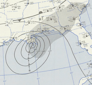
Hurricane Eloise was the most destructive tropical cyclone of the 1975 Atlantic hurricane season. The fifth tropical storm, fourth hurricane, and second major hurricane of the season, Eloise formed as a tropical depression on September 13 to the east of the Virgin Islands. The depression tracked westward and intensified into a tropical storm while passing to the north of Puerto Rico. Eloise briefly attained hurricane intensity soon thereafter, but weakened back to a tropical storm upon making landfall over Hispaniola. A weak and disorganized cyclone, Eloise emerged into open waters of the northern Caribbean Sea; upon striking the northern Yucatan Peninsula, it turned north and began to re-intensify. In the Gulf of Mexico, the cyclone quickly matured and became a Category 3 hurricane on September 23. Eloise made landfall along the Florida Panhandle west of Panama City before moving inland across Alabama and dissipating on September 24.

The Great Miami Hurricane of 1926 was a large and intense tropical cyclone that devastated the Greater Miami area of Florida and caused catastrophic damage in the Bahamas and the U.S. Gulf Coast in September 1926, accruing a US$100 million damage toll. The devastation wrought by the hurricane resulted in the end of Florida's land boom, and represented an early start to the Great Depression in the state. It has been estimated that a similar hurricane would cause about $235 billion in damage if it were to hit Miami in 2018.
Hurricane Carol was among the worst tropical cyclones on record to affect the states of Connecticut and Rhode Island in the United States. It developed from a tropical wave near the Bahamas on August 25, 1954, and slowly strengthened as it moved northwestward. On August 27, Carol intensified to reach winds of 105 mph (169 km/h), but weakened as its motion turned to a northwest drift. A strong trough of low pressure turned the hurricane northeastward, and Carol later intensified into a major hurricane. While paralleling the Mid-Atlantic and Southeastern United States, the storm produced strong winds and rough seas that caused minor coastal flooding and slight damage to houses in North Carolina, Virginia, Washington, D.C., Delaware, and New Jersey. The well-organized hurricane accelerated north-northeastward and made landfall on eastern Long Island, New York, and then over eastern Connecticut on August 31 with sustained winds estimated at 110-mph and a barometric pressure near 956 mb. Carol later transitioned into an extratropical cyclone over New Hampshire, on August 31, 1954.

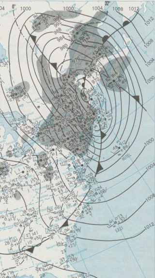
The 1944 Great Atlantic hurricane was a destructive and powerful tropical cyclone that swept across a large portion of the United States East Coast in September 1944. New England was most affected, though so were the Outer Banks, Mid-Atlantic states, and the Canadian Maritimes. The storm's ferocity and path drew comparisons to the 1938 Long Island Express, one of the worst storms in New England history.
The Ash Wednesday Storm of 1962 occurred on March 5–9, 1962 along the mid-Atlantic coast of the United States. Also known as the Great March Storm of 1962, it was considered by the U.S. Geological Survey to be one of the most destructive storms ever to affect the mid-Atlantic states. Classified as a level 5 or Extreme Nor'easter by the Dolan-Davis scale for classification of Atlantic Nor'easters it was one of the ten worst storms in the United States in the 20th century. It lingered through five high tides over a three-day period, killing 40 people, injuring over 1,000, and causing hundreds of millions in property damage in six states. The storm also deposited significant snowfall over the Southeast, with a regional snowfall index of 12.663.

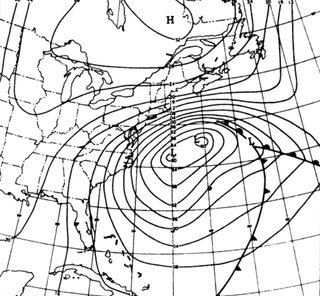
The 1991 Perfect Storm, also known as The No-Name Storm and the Halloween Gale/Storm, was a damaging and deadly nor'easter in October 1991. Initially an extratropical cyclone, the storm absorbed Hurricane Grace to its south and evolved into a small unnamed hurricane later in its life. Damage from the storm totaled over $200 million and thirteen people were killed in total, six of which were an outcome of the sinking of Andrea Gail, which inspired the book and later movie, The Perfect Storm. The nor'easter received the name, playing off the common expression, after a conversation between Boston National Weather Service forecaster Robert Case and author Sebastian Junger.

The 1933 Chesapeake–Potomac hurricane was among the most damaging hurricanes in the Mid-Atlantic states in the eastern United States. The sixth storm and third hurricane of the very active 1933 Atlantic hurricane season, it formed in the eastern Atlantic, where it moved west-northwestward and eventually became a Category 4 on the Saffir-Simpson hurricane wind scale. A strong ridge over New England allowed a continued northwest course, bringing the storm south of Bermuda and later toward the middle coast of the eastern United States. Advanced warning allowed hundreds of people to evacuate ahead of the hurricane making landfall. It did so in northeastern North Carolina on August 23 with winds of about 90 mph (140 km/h). Soon after, the eye crossed over Norfolk, Virginia, the first time that happened since 1821. The hurricane weakened into a tropical storm over northern Virginia shortly before passing near Washington, D.C., becoming the worst tropical cyclone there since 1896. Curving northward, the storm moved through Pennsylvania and New York before losing tropical characteristics on August 25. Now extratropical, the former hurricane moved across Atlantic Canada, dissipating on August 28.
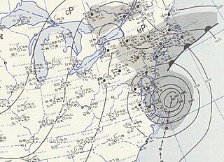
Hurricane Flossy originated from a tropical disturbance in the eastern Pacific Ocean and moved across Central America into the Gulf of Mexico as a tropical depression on September 21, 1956, which became a tropical storm on September 22 and a hurricane on September 23. The hurricane peaked with maximum sustained winds of 90 mph (140 km/h) before it struck the central Gulf coast of the United States as a Category 1 hurricane on September 24, and evolved into an extratropical cyclone on September 25. It was the first hurricane to affect oil refining in the Gulf of Mexico. The tropical cyclone led to flooding in New Orleans, and broke a drought across the eastern United States. The death toll was 15, and total damages reached $24.8 million (1956 USD).

Hurricane Daisy brought the worst flooding to New England since Hurricane Diane in 1955. The fourth named storm and second hurricane of the 1962 Atlantic hurricane season, Daisy developed from a tropical disturbance located well east of the Leeward Islands on September 29. Initially a tropical depression, it headed west-northwestward and failed to strengthen significantly. While located a short distance from the Leeward Islands, the depression curved northwestward and began intensifying. On October 2, the depression was upgraded to Tropical Storm Daisy. Around that time, the storm turned back to the west-northwest and continued to deepen. Daisy reached hurricane status late on October 3. Two days later, it became a Category 2 hurricane on the Saffir–Simpson hurricane wind scale, but briefly weakened back to a Category 1 on October 6.

The December 1992 nor'easter produced record high tides and snowfall across the northeastern United States. It developed as a low pressure area on December 10 over Virginia, and for two days it remained over the Mid-Atlantic states before moving offshore. In Maryland, the snowfall unofficially reached 48 in (1,200 mm); if verified, the total would have been the highest in the state's history. About 120,000 people were left without power in the state due to high winds. Along the Maryland coast, the storm was less severe than the Perfect Storm in the previous year, although the strongest portion of the storm remained over New Jersey for several days. In the state, winds reached 80 mph (130 km/h) in Cape May, and tides peaked at 10.4 ft (3.2 m) in Perth Amboy. The combination of high tides and 25 ft (7.6 m) waves caused the most significant flooding in the state since the Ash Wednesday Storm of 1962. Several highways and portions of the New York City Subway and Port Authority Trans-Hudson systems were closed due to the storm. Throughout New Jersey, the nor'easter damaged about 3,200 homes and caused an estimated $750 million in damage (1992 USD).

The January 1992 nor'easter was the second in a series of nor'easters in a 14-month period that produced strong winds, high tides, and flooding along the East Coast of the United States. It was a small, short-lived storm that was poorly forecast, intensifying rapidly on January 4 before striking the Eastern Shore of Virginia. The strongest quadrant of the storm moved over Delaware, and winds in the state reached 58 mph (93 km/h). The nor'easter weakened as it moved westward, and it dissipated over Virginia before the energy reformed and redeveloped offshore.

Tropical Storm Debby was a tropical cyclone that caused extensive flooding in North Florida and Central Florida during late June 2012. The fourth tropical cyclone and named storm of the 2012 Atlantic hurricane season, Debby developed from a trough of low pressure in the central Gulf of Mexico on June 23. At the time, Debby was the earliest fourth named storm to form within the Atlantic basin on record. Despite a projected track toward landfall in Louisiana or Texas, the storm headed the opposite direction, moving slowly north-northeast and northeastward. The storm slowly strengthened, and at 1800 UTC on June 25, attained its peak intensity with maximum sustained winds of 65 mph (100 km/h). Dry air, westerly wind shear, and upwelling of cold waters prevented further intensification over the next 24 hours. Instead, Debby weakened, and by late on June 26, it was a minimal tropical storm. At 2100 UTC, the storm made landfall near Steinhatchee, Florida with winds of 40 mph (65 km/h). Once inland, the system continued to weaken while crossing Florida, and dissipated shortly after emerging into the Atlantic on June 27.

The 1896 East Coast hurricane was a slow-moving tropical cyclone that battered the East Coast of the United States from Florida to New England in mid-October 1896. The fifth tropical cyclone of the 1896 Atlantic hurricane season, it formed on October 7 in the southern Gulf of Mexico, and caused minor damage in Florida while crossing the state two days later. From October 10 through 13, the hurricane drifted northeastward along the coast, reaching its peak intensity as the equivalence of a Category 2 hurricane on the modern-day Saffir–Simpson scale. The hurricane subjected many areas along the East Coast to days of high seas and damaging northeasterly winds, which halted shipping operations.

DiMillo's On the Water is a floating restaurant in Portland, Maine, United States. It is located on the former New York car ferry, which ran between Norfolk and Hampton, Virginia, then between Newport and Jamestown, Rhode Island. It is now permanently berthed at Portland's Long Wharf. The vessel is 206 feet (63 m) long, 65 feet (20 m) wide, and weighs 700 tons. The DiMillo family also owns the marina that surrounds the vessel.
