
The Upper West Side (UWS) is a neighborhood in the borough of Manhattan in New York City. It is bounded by Central Park on the east, the Hudson River on the west, West 59th Street to the south, and West 110th Street to the north. The Upper West Side is adjacent to the neighborhoods of Hell's Kitchen to the south, Columbus Circle to the southeast, and Morningside Heights to the north.

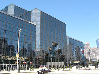
Riverside South is an urban development project in the Lincoln Square neighborhood of the Upper West Side of Manhattan, New York City. It was originated by six civic associations – The Municipal Art Society, Natural Resources Defense Council, New Yorkers for Parks, Regional Plan Association, Riverside Park Fund, and Westpride – in partnership with real estate developer Donald Trump. The largely residential complex, located on the site of a former New York Central Railroad yard, includes Trump Place and Riverside Center. The $3 billion project is on 57 acres (23 ha) of land along the Hudson River between 59th Street and 72nd Street.
Eleventh Avenue is a north–south thoroughfare on the far West Side of the borough of Manhattan in New York City, located near the Hudson River. Eleventh Avenue originates in the Meatpacking District in the Greenwich Village and West Village neighborhoods at Gansevoort Street, where Eleventh Avenue, Tenth Avenue, and West Street intersect. It is considered part of the West Side Highway between 22nd and Gansevoort Streets.

The Sail @ Marina Bay is a waterfront lifestyle condominium located in the Marina Bay area in Singapore. It was completed in 2008. The first tenants have moved into Central Park Tower in July 2008. Residents moved into Marina Bay Tower a few weeks later. The structure of The Sail is 245 m (804 ft) with 70 storeys and is one of Singapore's tallest condominia/apartment buildings. This development offers panoramic city view of Marina Bay and the sea. It is close to some of Singapore's famous landmarks such as Suntec City, Marina Bay Sands, Esplanade, Telok Ayer Market and the Singapore River. The Downtown MRT station is built a few meters to the West of the building. The building was erected on reclaimed land, and the Central Linear Park is built on the South Side next to the building.

Downtown Vancouver is the main central business district and the city center neighbourhood of Metro Vancouver, located on the northwestern shore of the Burrard Peninsula in the Lower Mainland region of British Columbia. The Downtown occupies most of the north shore of the False Creek inlet, which incises into the Burrard Peninsula creating the namesaked Downtown Peninsula, where the West End neighbourhood and Stanley Park are also located.
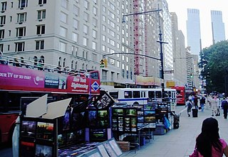
59th Street is a crosstown street in the New York City borough of Manhattan, running from York Avenue/Sutton Place on the East Side of Manhattan to the West Side Highway on the West Side. The three-block portion between Columbus Circle and Grand Army Plaza is known as Central Park South, since it forms the southern border of Central Park. The street is mostly continuous, except between Ninth Avenue/Columbus Avenue and Columbus Circle, where the Time Warner Center is located. While Central Park South is a bidirectional street, most of 59th Street carries one-way traffic.

57th Street is a broad thoroughfare in the New York City borough of Manhattan, one of the major two-way, east-west streets in the borough's grid. As with Manhattan's other "crosstown" streets, it is divided into its east and west sections at Fifth Avenue. The street runs from a small park overlooking the East River in the east to the West Side Highway along the Hudson River in the west. 57th Street runs through the neighborhoods of Sutton Place, Midtown Manhattan, and Hell's Kitchen from east to west.

72nd Street is one of the major bi-directional crosstown streets in New York City's borough of Manhattan. The street primarily runs through the Upper West Side and Upper East Side neighborhoods. It is one of the few streets to go through Central Park via Women's Gate, Terrace Drive, and Inventors Gate, though Terrace Drive is often closed to vehicular traffic.

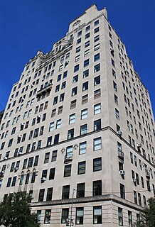
The Central Park West Historic District is located in Manhattan, New York City, United States along historic Central Park West, between 61st and 97th Streets. The district was added to the National Register of Historic Places on November 9, 1982. The district encompasses a portion of the Upper West Side-Central Park West Historic District as designated by the New York City Landmarks Preservation Commission, and contains a number of prominent New York City landmarks, including The Dakota Apartments, a National Historic Landmark. The buildings date from the late 19th century to the early 1940s and exhibit a variety of architectural styles. The majority of the district's buildings are of neo-Italian Renaissance style, but Art Deco is a popular theme as well.

Metsälä is a subdivision of Helsinki with about 1,000 inhabitants. It has predominantly small houses and it is situated between Maunula and Käpylä. Administratively speaking, Metsälä is a part of the Maunula district. The distance to Helsinki City Centre is about 6 kilometres from Metsälä. The primary housing type has been wooden single-family homes, and many terraced houses have been in the area in the 1970s. Nowadays Metsälä has few unbuilt lots.
Washington Park is a historically black neighborhood in northwest Atlanta encompassing historic residential, commercial, and community landmark buildings. It is situated two miles (3 km) west of the central business district of Atlanta. The combination of gridiron and curvilinear streets is a result of the neighborhood having been developed from four separate subdivision plats. One of these plats created Atlanta's first planned black neighborhood, while the other three were abandoned by white developers and adopted by Heman Perry, an early 20th-century black developer. Although Perry did not receive a formal education past the seventh grade, in 1913 he founded one of the largest black-owned companies in the United States, the Standard Life Insurance Company of Atlanta.

The city of Davenport, Iowa, United States has neighborhoods dating back to the 1840s. The Davenport Plan and Zoning Commission divided the city into five areas: downtown, central, east end, near north, and northwest and west end. The neighborhoods contain many architectural designs, including Victorian, Queen Anne, and Tudor Revival. Many of the original neighborhoods were first inhabited by German settlers.

The West Side, as the name implies, is a neighborhood in the western section of the New York State city of Binghamton. It is primarily an urban residential neighborhood with retail along Main Street and pockets of industrial buildings along the train tracks.
Bing & Bing was one of the most important apartment real estate developers in New York City in the early 20th century.
1040 Fifth Avenue is a luxury residential housing cooperative in the Upper East Side of Manhattan, New York City.

West Third Street Historic District is located on the west side of downtown Davenport, Iowa, United States. It was listed on the National Register of Historic Places in 1983. The historic district connects the central business district with the working-class neighborhoods of the West End. Its historical significance is its connection to Davenport's German-American community. Germans were the largest ethnic group to settle in Davenport.

Central Park Tower is a 98-story, 1,550 foot residential supertall skyscraper at 225 West 57th Street in the Midtown Manhattan neighborhood of New York City, along Billionaires' Row. Designed by Adrian Smith + Gordon Gill Architecture, the building has 98 above ground floors and three basement stories, although the top story is numbered 136. Central Park Tower is the second-tallest building in New York City, the United States, and the Western Hemisphere; the 14th tallest building in the world; the tallest primarily residential building in the world; and the tallest building outside Asia by roof height.

The Forest Park Historic District is a nationally recognized historic district located in Mason City, Iowa, United States. It was listed on the National Register of Historic Places in 2015. At the time of its nomination it contained 403 resources, which included 291 contributing buildings, of which 201 are houses and 90 are garages, and 112 non-contributing buildings. The historic district is a residential area located to the west of the central business district. It was platted between 1912 and 1916. Initial development in the 1910s was slow, but from the 1920s into the early 1940s, development was steady. It dropped off again after World War II as most of the lots had been developed by then. The houses range in height from one to 2½-stories. Those on Crescent, Linden, and Beaumont are larger in scale, while the rest are more modest in size. The foundations are generally brick or tile and the exteriors are clad in wood, with a few clad in brick. Architectural styles that were popular from early to mid-20th century are represented. The most popular include Prairie School, American Craftsman, Tudor Revival, Colonial Revival, and Modern. For the most part, the house designs came from a pattern book or catalogue. The streets on the west side of the district follow a grid pattern, while those on the east side are curvilinear. The neighborhood has a large tree canopy with trees planted in yards and in the boulevards along the streets.
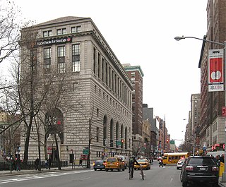
The Apple Bank Building, also known as the Central Savings Bank Building and 2100 Broadway, is a bank building and residential condominium at 2100–2114 Broadway on the Upper West Side of Manhattan in New York City. Constructed as a branch of the Central Savings Bank from 1926 to 1928, it occupies a trapezoidal city block bounded by 73rd Street to the south, Amsterdam Avenue to the east, 74th Street to the north, and Broadway to the west. The Apple Bank Building was designed by York and Sawyer and patterned after an Italian Renaissance-style palazzo.


