86 (MBTA bus)

Last updated

86
MBTA route 86 bus at Commonwealth Avenue, March 2022.JPG
A route 86 bus on Chestnut Hill Avenue in March 2022
Overview
System MBTA bus
GarageSomerville Garage [1]
Route
Locale Boston, Cambridge, and Somerville, Massachusetts
Start Sullivan Square station
End Reservoir station (Cleveland Circle)
Length6.79 miles (10.93 km) eastbound
6.70 miles (10.78 km) westbound
Daily ridership6,150 (2018) [2]

Route 86 is a local bus route in Boston, Cambridge, and Somerville, Massachusetts, operated by the Massachusetts Bay Transportation Authority (MBTA) as part of MBTA bus service. It operates on a circumferential route between Sullivan Square station and Reservoir station (Cleveland Circle) via Union Square, Somerville, Harvard Square, and Brighton Center. In 2018, it had the 18th-highest weekday ridership on the system, though it ranked 37th by number of weekday trips. [2] A 2018–19 MBTA review of its bus system found that route 86 had infrequent and unreliable service, including irregular scheduled headways, despite its high ridership and significance as a crosstown connecting route.

Contents

Transit service on three portions of the modern route date back to horsecar lines opened in the 19th century, with the section between Union Square and Sullivan Square opened in 1858. Two of those sections were converted to electric streetcars in the 1890s. Three overlapping bus routes (later designated 63, 86, and 91) were established between 1925 and 1931, replacing circumferential streetcar services and creating new connections. Route 86 ran between Union Square, Allston and Union Square, Somerville until it was extended to Sullivan Square in 1977 and 1981 to supplement route 91. In 1989, the western end was extended to Cleveland Circle, replacing route 63.

In December 2024, the eastern half of the route is planned to become part of route 109, with route 86 running only between Reservoir and Harvard.

Route

86 (MBTA bus) Route 86 runs between Sullivan Square station at Sullivan Square on the East Somerville / Charlestown, Boston border and Reservoir station at Cleveland Circle on the Brookline / Brighton, Boston border. From the Sullivan Square busway, it runs west along Cambridge Street / Washington Street, with short jogs on Prospect Street and Somerville Avenue at Union Square. It continues west along Washington Street / Kirkland Street, then diverts onto Quincy Street and Cambridge Street to reach Harvard Square. Westbound buses run on the surface through the square on Massachusetts Avenue, Brattle Street, and Eliot Street; eastbound buses enter the Harvard Bus Tunnel via Eliot Street and Bennett Street, and loop around Flagstaff Park to reach Cambridge Street. South of Harvard Square, the route runs south on John F. Kennedy Street / North Harvard Street to Barry's Corner, west on Western Avenue, and south on Leo M. Birmingham Parkway and Market Street to Brighton Center, then south on Chestnut Hill Avenue to the Reservoir station busway. [3] [2]

It operates as a crosstown/circumferential route, with MBTA subway connections at Sullivan Square (Orange Line), East Somerville (Green Line E branch), Union Square (Green Line D branch), Harvard (Red Line), Chestnut Hill Avenue (Green Line B branch), Cleveland Circle (Green Line C branch), and Reservoir (Green Line D branch). Connections to a number of MBTA bus routes are possible; Brighton Center, Harvard station, Union Square, and Sullivan Square are major transfer locations. [3] [2] Ridership turnover along the route is high, as many passengers transfer or terminate at these stations and hubs. [2]

One-way running distances are 6.79 miles (10.93 km) eastbound and 6.70 miles (10.78 km) westbound. [1] Scheduled one-way running times range from 40 minutes off-peak to 55 minutes at peak, with shorter times during early mornings and late nights. Service operates from about 5:00 am to 12:30 am on weekdays and Saturdays, and from about 7:30 am to 9:30 pm on Sundays. [2] As of February 2022, weekday peak headways are 11–12 minutes, with 35-minute midday headways and 45-minute evening headways. Saturday service has 27-minute headways, while Sunday service has 35-minute headways. [4]

Route 86 runs as a local route with standard local bus fare. In 2018, the route averaged 6,150 boardings on weekdays; average weekend ridership was 3,040 on Saturdays and 1,840 on Sundays. This made it the 18th-highest-ridership route in the MBTA bus system, with more boardings than four of the key bus routes. Despite this, it ranked 37th by number of weekday trips, leading to crowding on many trips. [2]

History

Early lines

Several portions of the route originated as horsecar and streetcar lines:

Bus replacements

Streetcar tracks on Market Street in Brighton in 1930 Market Street at Wexford Street, Brighton, October 1930.jpg
Streetcar tracks on Market Street in Brighton in 1930

Horsecar and streetcar operations in Boston and surrounding municipalities were consolidated under the West End Street Railway in the 1880s; it was leased by the Boston Elevated Railway (BERy) in 1897. The BERy began operating bus service in 1922. [5] :46 A Harvard Square–Union Square, Somerville bus route began operation on August 22, 1925. It was extended from Harvard Square to Union Square, Allston on December 19. [13] [5] :50

By 1930, the Union Square–Sullivan Square segment was operated as part of a Central Square–Sullivan Square streetcar line. On February 1, the Central Square–Union Square segment was replaced by a bus route, leaving a Union Square–Sullivan Square streetcar shuttle. [14] On November 15, that shuttle was replaced with a new bus route at the city's request, with the intention of reducing congestion in Union Square. [15] [16] [5] :200 The two bus routes were connected into a single route on February 14, 1931, again forming a Central Square–Sullivan Square route. [17] The Sullivan–Union tracks remained in use for non-revenue equipment moves until 1951. [18] :143

On June 8, 1931, the Brighton Center–Central Square streetcar line was replaced with buses and extended south to Commonwealth Avenue. [19] [5] :54 Initially, only half of service operated south of Brighton Center. [20] (The Western Avenue tracks would remain in use until 1950 for Watertown service, which is now bus route 70. [5] :210)

Later history

In 1940–41, the BERy reassigned its public-facing route numbers. [21] :27 The Commonwealth Avenue–Central Square route was designated route 63, Union Square–Union Square as route 86, and Central Square–Sullivan Square as route 91. [22] The Western Avenue segment of route 63 was eliminated in February 1943 as a wartime measure, but it was extended slightly from Commonwealth Avenue to Cleveland Circle. The Western Avenue segment was resumed in 1946, forming a Cleveland Circle–Central Square route. [5] :63

The BERy was replaced in 1947 by the Metropolitan Transit Authority (MTA). Sunday service on route 63 ended in 1958. [23] On July 4, 1959, the southern terminal was extended slightly from Cleveland Circle to a new busway at Reservoir station as the Riverside Line opened, though the terminus was still listed as "Cleveland Circle" in public schedules. [24] In September 1962, the MTA through-routed several routes as part of experimental attempts to increase ridership. Route 63 was interlined with route 83 to form a Cleveland Circle–Porter Square route, while route 91 was interlined with route 93 to form a Central Square–Haymarket route. Neither was successful; they returned to their previous terminals in March 1964 and June 1963, respectively. [23]

A route 86 bus at Sullivan Square in 2006 MBTA route 86 bus at Sullivan station, July 2006.jpg
A route 86 bus at Sullivan Square in 2006

The MTA was in turn replaced by the Massachusetts Bay Transportation Authority (MBTA) in 1964. Sunday service on a Union Square, Somerville–Cleveland Circle route – a combination of routes 63, 64, and 86 – began in June 1973. In September 1977, peak hour route 86 service was extended to Sullivan Square, supplementing route 91. [23] The Sunday route was discontinued in April 1981, but off-peak and Saturday route 86 service was extended to Sullivan Square. [25] [23] At the same time, weekday evening and Saturday morning service on routes 63 and 64 was combined into a loop that followed route 64 westbound and route 63 eastbound. This loop route began running on Sundays in January 1983. From 1979 to the early 1980s, route 86 was detoured over Somerville Avenue and Dane Street west while the Washington Street bridge over the Fitchburg Line was rebuilt. [23]

In December 1989, route 63 was discontinued, with route 86 realigned over much of the former route to form a Cleveland Circle–Sullivan Square circumferential line. Route 66 was extended from Union Square to Harvard Square to replace the realigned segment of route 86 (supplementing it between Barry's Corner and Harvard Square), while route 70 continued serving the discontinued east portion of route 63. Sunday service on route 86 began at this time. Elderly patrons who lost their one-seat ride from Brighton to Central Square petitioned for route 63 to return. As a result, midday Cleveland Circle–Central Square service, operating as a variation of route 64, operated from December 1990 to December 1993. [23]

Peak-hour short turn trips of route 86 were added in the 1990s. Limited-stop crosstown route CT2 was extended to Sullivan Square in September 2000, supplementing routes 86 and 91 on the Union Square–Sullivan Square segment. In September 2008, eastbound buses were rerouted through the Harvard Bus Tunnel, rather than passing through Harvard Square on the surface. Most peak-hour short turn trips were discontinued in September 2011. From April 2019 to May 2020, route 86 was detoured via Cross Street while the Lowell Line overhead bridge was rebuilt as part of the Green Line Extension project. [23] A 2018–19 MBTA review of its bus system found that route 86 had infrequent and unreliable service, including irregular scheduled headways, despite its high ridership and significance as a crosstown connecting route. [2] No short-term changes to the routing were recommended. [26]

By 2022, scheduled headways were more consistent than during the 2018–19 review. [4] [27] In May 2022, the MBTA released a draft plan for a systemwide network redesign. The draft called for the 86 to be cut to a Harvard–Reservoir route; the Harvard–Sullivan Square segment would become an extension of route 109 with higher frequency. [28] [29] A revised proposal in November 2022 kept these changes. [30] [31] As of April 2024, the change is planned to occur in December 2024. [32]

Related Research Articles

<span class="mw-page-title-main">Green Line (MBTA)</span> Light rail system

The Green Line is a semi-metro system run by the Massachusetts Bay Transportation Authority (MBTA) in the Boston, Massachusetts, metropolitan area. It is the oldest MBTA subway line, and with tunnel sections dating from 1897, the oldest subway in North America. It runs underground through downtown Boston, and on the surface into inner suburbs via six branches on radial boulevards and grade-separated alignments. With an average daily weekday ridership of 137,700 in 2019, it is the third most heavily used light rail system in the country. The line was assigned the green color in 1967 during a systemwide rebranding because several branches pass through sections of the Emerald Necklace of Boston.

<span class="mw-page-title-main">Orange Line (MBTA)</span> Rapid transit line in Greater Boston

The Orange Line is a rapid transit line operated by the Massachusetts Bay Transportation Authority (MBTA) as part of the MBTA subway system. The line runs south on the surface from Oak Grove station in Malden, Massachusetts through Malden and Medford, paralleling the Haverhill Line, then crosses the Mystic River on a bridge into Somerville, then into Charlestown. It passes under the Charles River and runs through Downtown Boston in the Washington Street Tunnel. The line returns to the surface in the South End, then follows the Southwest Corridor southwest in a cut through Roxbury and Jamaica Plain to Forest Hills station.

<span class="mw-page-title-main">Harvard station</span> Subway station in Cambridge, Massachusetts, US

Harvard station is a rapid transit and bus transfer station in Cambridge, Massachusetts. Located at Harvard Square, it serves the MBTA's Red Line subway system as well as MBTA buses. Harvard averaged 18,528 entries each weekday in FY2019, making it the third-busiest MBTA station after Downtown Crossing and South Station. Five of the fifteen key MBTA bus routes stop at the station.

<span class="mw-page-title-main">Davis station (MBTA)</span> Rapid transit station in Somerville, Massachusetts, US

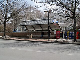
Davis station is an underground Massachusetts Bay Transportation Authority (MBTA) Red Line rapid transit station located at Davis Square in Somerville, Massachusetts. The accessible station has a single island platform for the Red Line, as well as a dedicated busway on the surface. It opened in 1984 as part of the Red Line Northwest Extension project.

<span class="mw-page-title-main">MBTA bus</span> Greater Boston bus network

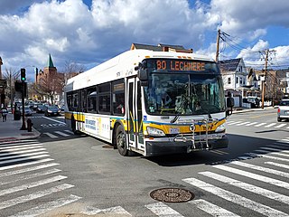
The Massachusetts Bay Transportation Authority (MBTA) operates 152 bus routes in the Greater Boston area. The MBTA has a policy objective to provide transit service within walking distance for all residents living in areas with population densities greater than 5,000 inhabitants per square mile (1,900/km2) within the MBTA's service district. Much of this service is provided by bus. In 2023, the system had a ridership of 91,459,700, or about 303,300 per weekday as of the fourth quarter of 2023.

<span class="mw-page-title-main">Lechmere station</span> Light rail station in Cambridge, Massachusetts, US

Lechmere station is a Massachusetts Bay Transportation Authority (MBTA) Green Line light rail station in Lechmere Square in East Cambridge, Massachusetts. It is located on the east side of Monsignor O'Brien Highway near First Street, adjacent to the NorthPoint development. The accessible elevated station has a single island platform, with headhouses at both ends. It opened on March 21, 2022, as part of the Green Line Extension (GLX). Lechmere station is served by Green Line D branch and E branch service.

<span class="mw-page-title-main">Reservoir station (MBTA)</span> Light rail station in Brookline, Massachusetts, US

Reservoir station is a light rail station on the MBTA Green Line D branch, located in Brookline, Massachusetts, adjacent to the Cleveland Circle area of Brighton. The station is adjacent to Reservoir Yard and Carhouse, with the Cleveland Circle terminus of the C branch just a block away. With a daily ridership of 3,395, Reservoir is the second-busiest surface stop on the D branch.

<span class="mw-page-title-main">MBTA key bus routes</span> Bus routes utilized and ran by the MBTA

Key bus routes of the Massachusetts Bay Transportation Authority (MBTA) system are 15 routes that have high ridership and higher frequency standards than other bus lines, according to the 2004 MBTA Service Policy. Together, they account for roughly 40% of the MBTA's total bus ridership. These key bus routes ensure basic geographic coverage with frequent service in the densest areas of Boston, and connect to other MBTA services to give access to other areas throughout the region.

<span class="mw-page-title-main">Green Line E branch</span> Light rail line

The E branch is a light rail line in Boston, Cambridge, Medford, and Somerville, Massachusetts, operating as part of the Massachusetts Bay Transportation Authority (MBTA) Green Line. The line runs in mixed traffic on South Huntington Avenue and Huntington Avenue between Heath Street and Brigham Circle, in the median of Huntington Avenue to Northeastern University, then into the Huntington Avenue subway. The line merges into the Boylston Street subway just west of Copley, running to North Station via the Tremont Street subway. It then follows the Lechmere Viaduct to Lechmere, then the Medford Branch to Medford/​Tufts. As of February 2023, service operates on eight-minute headways at weekday peak hours and eight to nine-minute headways at other times, using 13 to 17 trains.

<span class="mw-page-title-main">Green Line C branch</span> Light rail line in Massachusetts, US

The C branch, also called the Beacon Street Line or Cleveland Circle Line, is one of four branches of the Massachusetts Bay Transportation Authority's Green Line light rail system in the Boston, Massachusetts metropolitan area. The line begins at Cleveland Circle in the Brighton neighborhood of Boston and runs on the surface through Brookline along the median of Beacon Street. Reentering Boston, the line goes underground through the St. Mary's Street incline and joins the B and D branches at Kenmore. Trains run through the Boylston Street subway to Copley where the E branch joins, then continue through the Tremont Street subway to downtown Boston. The C branch has terminated at Government Center station since October 2021.

<span class="mw-page-title-main">Green Line B branch</span> Light rail line in Boston, Massachusetts

The B branch, also called the Commonwealth Avenue branch or Boston College branch, is a branch of the MBTA Green Line light rail system which operates on Commonwealth Avenue west of downtown Boston, Massachusetts. One of four branches of the Green Line, the B branch runs from Boston College station down the median of Commonwealth Avenue to Blandford Street. There, it enters Blandford Street portal into Kenmore station, where it merges with the C and D branches. The combined services run into the Boylston Street subway and Tremont Street subway to downtown Boston. B branch service has terminated at Government Center since October 2021. Unlike the other branches, the B branch runs solely through the city limits of Boston. The Green Line Rivalry between Boston College and Boston University is named in reference to the B branch, which runs to both universities.

<span class="mw-page-title-main">Green Line A branch</span> Former streetcar line in Massachusetts, US

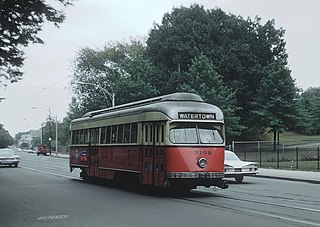
The A branch or Watertown Line was a streetcar line in the Boston, Massachusetts, area, operating as a branch of the Massachusetts Bay Transportation Authority Green Line. The line ran from Watertown through Newton Corner, Brighton, and Allston to Kenmore Square, then used the Boylston Street subway and Tremont Street subway to reach Park Street station.

<span class="mw-page-title-main">Boston-area streetcar lines</span>

As with many large cities, a large number of Boston-area streetcar lines once existed, and many continued operating into the 1950s. However, only a few now remain, namely the four branches of the Green Line and the Ashmont–Mattapan High-Speed Line, with only one running regular service on an undivided street.

<span class="mw-page-title-main">Sullivan Square station</span> Rapid transit station in Boston, Massachusetts, US

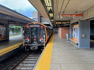
Sullivan Square station is a rapid transit station on the MBTA subway Orange Line, located adjacent to Sullivan Square in the Charlestown neighborhood of Boston, Massachusetts. It is a major transfer point for MBTA bus service, with 12 routes using a two-level busway. The station has two island platforms serving the two active Orange Line tracks plus an unused third track. The Haverhill Line and Newburyport/Rockport Line pass through the station on separate tracks but do not stop.

The Urban Ring was a proposed project of the Massachusetts Bay Transportation Authority and the Massachusetts Department of Transportation, to develop new public transportation routes that would provide improved circumferential connections among many existing transit lines that project radially from downtown Boston. The Urban Ring Corridor is located roughly one to two miles from downtown Boston, passing through the Massachusetts cities of Boston, Chelsea, Everett, Medford, Somerville, Cambridge, and Brookline. The project was expected to convert 41,500 car trips to transit trips daily.

<span class="mw-page-title-main">History of the MBTA</span> Story of mass transit in the Boston US area

The history of the Massachusetts Bay Transportation Authority (MBTA) and its predecessors spans two centuries, starting with one of the oldest railroads in the United States. Development of mass transportation both followed existing economic and population patterns, and helped shape those patterns.

<span class="mw-page-title-main">Babcock Street station</span> Light rail station in Boston, Massachusetts, US

Babcock Street station is a light rail stop on the Massachusetts Bay Transportation Authority (MBTA) Green Line B branch, located in the median of Commonwealth Avenue in the west part of the Boston University campus. The accessible station has two side platforms serving the line's two tracks, with access at Babcock Street and Pleasant Street.

<span class="mw-page-title-main">Green Line Extension</span> Light rail system in greater Boston, US

The Green Line Extension (GLX) was a construction project to extend the Massachusetts Bay Transportation Authority (MBTA) Green Line light rail system northwest into Somerville and Medford, two inner suburbs of Boston, Massachusetts. The project opened in two phases in 2022 at a total cost of $2.28 billion. Total ridership on the 4.3-mile (6.9 km) extension is estimated to reach 45,000 one-way trips per day in 2030.
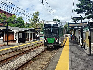
<span class="mw-page-title-main">Newton Corner station</span> Transit hub in Newton, Massachusetts, US

Newton Corner is an MBTA bus transfer point in the Newton Corner neighborhood of Newton, Massachusetts, located on the rotary where Washington Street crosses the Massachusetts Turnpike. The Newton Corner station, known simply as Newton for much of its lifetime, served commuters on the Worcester Line from 1834 to 1959. A streetcar stop, located on the surface streets, served a number of routes beginning in 1863, including the Green Line A branch until 1969. Newton Corner is now a stop and transfer point for MBTA routes 52, 57, 501, 504, 553, 554, 556, and 558, which include express routes to downtown Boston as well as local routes, with stops on the north and south sides of the rotary.

<span class="mw-page-title-main">Ipswich Street line</span> Former streetcar line in Boston and Brookline, Massachusetts

The Ipswich Street line was a streetcar line in Boston and Brookline, Massachusetts. The line ran on Boylston Street and Ipswich Street in the Fenway–Kenmore neighborhood, and on Brookline Avenue through what is now the Longwood Medical Area to Brookline Village.

References

  1. 1 2 "Ridership and Service Statistics" (PDF) (14th ed.). Massachusetts Bay Transportation Authority. 2014.
  2. 1 2 3 4 5 6 7 8 "Route 86" (PDF). Massachusetts Bay Transportation Authority. December 2018.
  3. 1 2 "2023–24 System Map". Massachusetts Bay Transportation Authority. December 17, 2023.
  4. 1 2 Belcher, Jonathan (January–February 2022). "MBTA Vehicle Inventory as of February 28, 2022". Rollsign. Vol. 59, no. 1–2. Boston Street Railway Association. p. 24.
  5. 1 2 3 4 5 6 7 8 9 10 Humphrey, Thomas J. (August 2020). "Origin and Development of the Fixed-Route Local Bus Transportation Network in the Cities and Towns of the Massachusetts Bay Transportation Authority District as of December 31, 1973: Revised Edition" (PDF). NETransit.
  6. "Union Square Electrics". Boston Globe. August 9, 1895. p. 7 via Newspapers.com.
  7. 1 2 Ninth Annual Report of the West End Street Railway Company for the Year Ending September 30, 1896. Walker, Young & Co. 1896. p. 7 via Internet Archive.
  8. "Horse Line No Longer". Boston Globe. October 15, 1895. p. 7 via Newspapers.com.
  9. "The Boston Elevated Railway Company: A Model Road". Street Railway Review. Vol. 8. August 1898. pp. 525–545.
  10. "Will be ready for use next month". Boston Globe. June 14, 1901. p. 3 via Newspapers.com.
  11. "The Union Street Railway". Boston Globe. December 30, 1879. p. 4 via Newspapers.com. Open Access logo PLoS transparent.svg
  12. Clarke, Bradley H.; Cummings, O.R. (1997). Tremont Street Subway: A Century of Public Service. Boston Street Railway Association. p. 58. ISBN   0938315048.
  13. "Elevated to Run Busses Allston to Somerville". Boston Globe. December 16, 1925. p. 16 via Newspapers.com.
  14. "Changes in Bus Service Announced by Elevated". Boston Globe. February 1, 1930. p. 4 via Newspapers.com.
  15. "Many Seek Busses to Replace Trolley". Boston Globe. September 11, 1930. p. 12 via Newspapers.com.
  16. "Extension of El Bus Service in Somerville". Boston Globe. November 14, 1930. p. 7 via Newspapers.com.
  17. "Central-Sq Bus Line to be Extended to Sullivan Sq". Boston Globe. February 13, 1931. p. 11 via Newspapers.com.
  18. Clarke, Bradley H. (2015). Streetcar Lines of the Hub: Boston's MTA Through Riverside and Beyond. Boston Street Railway Association. ISBN   9780938315070.
  19. "Brighton–Cambridge Bus Service Announced". Boston Globe. June 6, 1931. p. 21 via Newspapers.com.
  20. "A Decade of the Bus on the "El": Part II: Bus Routes of the Last Five Years". Co-operation. Vol. 11, no. 8. Boston Elevated Railway. August 1932. p. 124.
  21. Clarke, Bradley H. (2003). Streetcar Lines of the Hub – The 1940s. Boston Street Railway Association. ISBN   0938315056.
  22. Lufkin, Richard F. (1942), Boston Elevated Railway System Route Map, Boston Elevated Railway via Wikimedia Commons
  23. 1 2 3 4 5 6 7 Belcher, Jonathan. "Changes to Transit Service in the MBTA district" (PDF). Boston Street Railway Association.
  24. "Plenty of Parking on New M.T.A. Highland Branch". Boston Globe. June 16, 1959. p. 33 via Newspapers.com.
  25. "The bus routes affected". Boston Globe. April 3, 1981. p. 19 via Newspapers.com.
  26. "Better Bus Project Route Proposals" (PDF). Massachusetts Bay Transportation Authority. January 2019.
  27. "86 Sullivan Sq Sta – Reservoir Sta" (PDF). Massachusetts Bay Transportation Authority. March 13, 2022.
  28. "A better bus network: new connections, more service, more frequency. See what this means in Cambridge" (PDF). Massachusetts Bay Transportation Authority. May 2022.
  29. "Draft Bus Network Redesign Map" (PDF). Massachusetts Bay Transportation Authority. May 2022.
  30. "What we changed from the May 2022 Proposal" (PDF). Massachusetts Bay Transportation Authority. November 7, 2022.
  31. "Revised Bus Network Fall 2022" (PDF). Massachusetts Bay Transportation Authority. November 3, 2022.
  32. "Phase 1 Service Changes". Massachusetts Bay Transportation Authority. April 2024. Retrieved April 5, 2024.

Commons-logo.svg Media related to 86 (MBTA bus) at Wikimedia Commons