
Boston College station is a light rail station on the MBTA Green Line B branch. It is located at St. Ignatius Square on the Boston College campus near the intersection of Commonwealth Avenue and Lake Street, on the border between the Brighton neighborhood of Boston and the Chestnut Hill neighborhood of Newton, Massachusetts. Originally opened in 1896, it has been the terminus of the Commonwealth Avenue line since 1900. The current station is planned to be replaced by a new station located in the median of Commonwealth Avenue just east of Lake Street.

Reservoir station is a light rail station on the MBTA Green Line D branch, located in Brookline, Massachusetts, adjacent to the Cleveland Circle area of Brighton. The station is adjacent to Reservoir Yard and Carhouse, with the Cleveland Circle terminus of the C branch just a block away. With a daily ridership of 3,395, Reservoir is the second-busiest surface stop on the D branch.

The E branch is a light rail line in Boston, Cambridge, Medford, and Somerville, Massachusetts, operating as part of the Massachusetts Bay Transportation Authority (MBTA) Green Line. The line runs in mixed traffic on South Huntington Avenue and Huntington Avenue between Heath Street and Brigham Circle, in the median of Huntington Avenue to Northeastern University, then into the Huntington Avenue subway. The line merges into the Boylston Street subway just west of Copley, running to North Station via the Tremont Street subway. It then follows the Lechmere Viaduct to Lechmere, then the Medford Branch to Medford/Tufts. As of February 2023, service operates on eight-minute headways at weekday peak hours and eight to nine-minute headways at other times, using 13 to 17 trains.

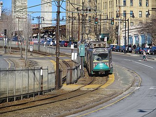
The C branch, also called the Beacon Street Line or Cleveland Circle Line, is one of four branches of the Massachusetts Bay Transportation Authority's Green Line light rail system in the Boston, Massachusetts metropolitan area. The line begins at Cleveland Circle in the Brighton neighborhood of Boston and runs on the surface through Brookline along the median of Beacon Street. Reentering Boston, the line goes underground through the St. Mary's Street incline and joins the B and D branches at Kenmore. Trains run through the Boylston Street subway to Copley where the E branch joins, then continue through the Tremont Street subway to downtown Boston. The C branch has terminated at Government Center station since October 2021.

The B branch, also called the Commonwealth Avenue branch or Boston College branch, is a branch of the MBTA Green Line light rail system which operates on Commonwealth Avenue west of downtown Boston, Massachusetts. One of four branches of the Green Line, the B branch runs from Boston College station down the median of Commonwealth Avenue to Blandford Street. There, it enters Blandford Street portal into Kenmore station, where it merges with the C and D branches. The combined services run into the Boylston Street subway and Tremont Street subway to downtown Boston. B branch service has terminated at Government Center since October 2021. Unlike the other branches, the B branch runs solely through the city limits of Boston. The Green Line Rivalry between Boston College and Boston University is named in reference to the B branch, which runs to both universities.

Waban station is a surface-level light rail station on the Massachusetts Bay Transportation Authority's Green Line D branch, located just south of Beacon Street at Waban Square in the Waban section of Newton, Massachusetts. The station is located below grade; access to both platforms is via Wyman Street on the outbound side of the tracks or a stairway from Beacon Street. Waban is not accessible.

Back of the Hill station is a surface stop on the light rail MBTA Green Line E branch, located in the Mission Hill neighborhood of Boston, Massachusetts. It is named after, and primarily serves, the adjacent Back of the Hill apartment complex, a Section 8 development for elderly and disabled residents. Back of the Hill is located on the street running section of the E branch on South Huntington Avenue. The station has no platforms; passengers wait in bus shelters on the sidewalks and cross a traffic lane to reach Green Line trains.

Cleveland Circle station is a surface light rail station on the MBTA Green Line C branch, located in the Brighton neighborhood of Boston, at Cleveland Circle. Cleveland Circle station is accessible, with raised platforms to accommodate low-floor light rail vehicles.

Beaconsfield is an MBTA light rail station in Brookline, Massachusetts. It serves the Green Line D branch. It is located off Dean Road and Beaconsfield Road just south of Beacon Street. Like the other stops on the line, it was a commuter rail station on the Boston and Albany Railroad's Highland branch until 1958, when the line was closed and converted to a branch of what is now the Green Line. The station reopened along with the rest of the line in 1959.

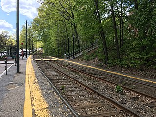
Eliot station is a light rail station on the MBTA Green Line D branch located just north of Route 9 between the Newton Highlands and Newton Upper Falls villages of Newton, Massachusetts. The station has a parking lot at the end of Lincoln Street, a pedestrian entrance from Meredith Avenue, and pedestrian entrances from both sides of Route 9. A footbridge, built in 1977, crosses Route 9 adjacent to the railroad bridge.

Chestnut Hill station is a light rail station on the MBTA Green Line D branch, located off Hammond Street north of Massachusetts Route 9 in the Chestnut Hill neighborhood of Newton, Massachusetts. The station has two side platforms serving the line's two tracks. Chestnut Hill station is not accessible, but renovations are planned.

South Street station is a light rail surface stop on the MBTA Green Line B branch, located in the median of Commonwealth Avenue east of South Street in the Brighton neighborhood of Boston, Massachusetts. South Street is the lowest-ridership stop on the B branch, with just 214 daily boardings by a 2011 survey.

Summit Avenue station is a light rail stop on the MBTA Green Line C branch, located in the median of Beacon Street between Winchester Street and Summit Avenue in the Coolidge Corner neighborhood of Brookline, Massachusetts. The stop has two low side platforms that serve the line's two tracks; it is not accessible.
Brandon Hall station is a light rail stop on the MBTA Green Line C branch in Brookline, Massachusetts. The station's name is an anachronism, as it was named for Brandon Hall, a large hotel built in 1904 just south of the station which burned down on April 26, 1946, after housing 400 SPARS during World War II.

Englewood Avenue station is a light rail station on the MBTA Green Line C branch located in the median of Beacon Street just west of Englewood Avenue in Brookline, Massachusetts. The station consists of two low side platforms which serve the C branch's two tracks. Englewood Avenue is not accessible.

Babcock Street station is a light rail stop on the Massachusetts Bay Transportation Authority (MBTA) Green Line B branch, located in the median of Commonwealth Avenue in the west part of the Boston University campus. The accessible station has two side platforms serving the line's two tracks, with access at Babcock Street and Pleasant Street.

Packards Corner station is a light rail stop on the MBTA's Green Line B branch located at Packard's Corner—the intersection of Commonwealth Avenue and Brighton Avenue—in Allston, Boston, Massachusetts. The station is located in a median between the westbound travel lanes and frontage road of Commonwealth Avenue.

Amory Street station is a light rail stop on the Massachusetts Bay Transportation Authority (MBTA) Green Line B branch, located in the median of Commonwealth Avenue in the west part of the Boston University campus. The accessible station has two side platforms serving the line's two tracks, with access at Amory Street and St. Paul Street.
Sutherland Road station is a light rail stop on the MBTA Green Line B branch, located in the median of Commonwealth Avenue at its intersection with Sutherland Road, in Brighton, Boston, Massachusetts. The stop consists of two side platforms, which serve the B branch's two tracks. The platforms are at track level and the stop is not accessible. Track work in 2018–19, which included replacement of platform edges at several stops, triggered requirements for accessibility modifications at those stops. Design for Sutherland Road and four other B Branch stops was 30% complete by December 2022. As of November 2023, construction is expected to begin in spring 2025. A design shown in March 2024 called for the platforms to be rebuilt at their current locations. In May 2024, the Federal Transit Administration awarded the MBTA $67 million to construct accessible platforms at 14 B and C branch stops including Sutherland Road.

Chiswick Road station is a light rail station on the MBTA's Green Line B branch, located in the median of Commonwealth Avenue north of Chiswick Road in the Brighton neighborhood of Boston, Massachusetts. Chiswick Road consists of two side platforms, which serve the B branch's two tracks.


