Park Street station (MBTA)

Last updated
Park Street
Park Street MBTA Red Line Island Platform, April 2024.jpg
A southbound Red Line train leaving Park Street station in 2024
General information
Location Tremont Street and Park Street
Boston, Massachusetts
Coordinates 42°21′23″N71°03′45″W / 42.3563°N 71.0625°W / 42.3563; -71.0625
Line(s) Cambridge Tunnel
Tremont Street subway
Platforms2 island platforms, 1 side platform (Green Line)
1 island platform, 2 side platforms (Red Line)
Tracks4 (upper level - Green Line)
2 (lower level - Red Line)
ConnectionsAiga bus trans.svg MBTA bus: 43
      Orange Line and MBTA bus at Downtown Crossing station (via Winter Street Concourse)
Construction
Structure typeUnderground
Platform levels2
AccessibleYes
History
OpenedSeptember 1, 1897 (1897-09-01) (upper level)
March 23, 1912 (1912-03-23) (lower level)
Rebuilt1915, 1936, 1977–79, 1980s, 2004, 2012
Passengers
FY201916,571 (weekday average boardings) [1]
Services
Preceding station MBTA.svg MBTA Following station
Boylston Green Line Government Center
Terminus
Boylston Green Line
Boylston
toward Riverside
Green Line Government Center
toward Union Square
Boylston
toward Heath Street
Green Line Government Center
Charles/MGH
toward Alewife
Red Line Downtown Crossing
toward Ashmont or Braintree
Boylston
toward Nubian
Silver Line
SL5
Terminus
Chinatown
One-way operation
Former services
Preceding station MBTA.svg MBTA Following station
Boylston
toward Watertown
Green Line
Discontinued 1969
Terminus
Preceding station Boston Elevated Railway Following station
Boylston
toward Dudley
Main Line Elevated
1901-1908
Scollay Square
Location
Park Street station (MBTA)

Park Street station is an MBTA subway station in Boston, Massachusetts. It is located at the intersection of Park Street and Tremont Street at the eastern edge of Boston Common in Downtown Boston. One of the two oldest stations on the "T" (the other is Boylston), and part of the oldest subway line in the United States, [2] Park Street is the transfer point between the Green and Red lines, as one of the quartet of "hub stations" on the MBTA subway system. Park Street is the fifth-busiest station in the MBTA network, with an average of 16,571 entries each weekday in FY2019. [1]

Contents

History

Initial construction

Tremont Street subway

Plan of the Tremont Street subway (Green Line) level of Park Street in 1898; the station has since been substantially modified. Park Street plan.png
Plan of the Tremont Street subway (Green Line) level of Park Street in 1898; the station has since been substantially modified.

The southern section of the Tremont Street subway from the Public Garden incline through Boylston to Park Street opened on September 1, 1897, followed on October 1 by the spur to the Pleasant Street Portal. [3] The station was built with 4 tracks serving 2 island platforms; these were connected by two loops, allowing streetcars from the south and west to reverse direction and return to the portals and surface routes.

On September 3, 1898, the tunnel was extended to Scollay Square, Adams Square, Haymarket Square, and the Canal Street Incline. [3] Some cars ran all the way through the tunnel on the outer tracks; others continued to loop at Park Street.

Boylston and Park Street were built with rectangular stone headhouses designed by Edmund M. Wheelwright that did not aesthetically match the Common. Unlike the interior decor, the headhouses were sharply criticized as "resembling mausoleums" and "pretentiously monumental". [4] [5] Later stations on the East Boston Tunnel and Washington Street Tunnel used more modest headhouse designs in response to this criticism. [4]

Electric destination indicator boards were first installed at Park Street in 1899, replacing an announcer with a megaphone. [6] [7] :22 Signalmen used metal picks to complete a circuit, lighting up a numeral indicating which berth the car arriving on a given route would stop at. [6]

Main Line Elevated

The southbound platform in August 1901, showing the wooden high-level platforms for Elevated trains Southbound platform at Park Street station, August 1901.jpg
The southbound platform in August 1901, showing the wooden high-level platforms for Elevated trains

On June 10, 1901, the Main Line Elevated began running through the Tremont Street subway. The platforms at Park Street were retrofitted with raised wooden sections to allow elevated trains to run on the outer tracks to the Pleasant Street Portal, while streetcars continued to use the inner tracks and inner loop, entering the subway from the Public Garden incline. [3] This arrangement lasted until Main Line service was moved to a separate tunnel under parallel Washington Street. Elevated trains last ran through the tunnel on November 28, 1908; they moved to the Washington Street Tunnel on November 30, and streetcar service returned to all tracks on December 4. [3] [8]

Cambridge subway

Cambridge subway platforms at Park Street Under in September 1912 Park Street Under platforms, September 1912.jpg
Cambridge subway platforms at Park Street Under in September 1912

On March 23, 1912, the Cambridge subway opened from Harvard Square to Park Street Under. [3] Park Street Under was built with two tracks with one side platform each and a center island platform, intended as a Spanish solution setup to speed boarding. Stairwells were added to the original platform level to connect to the lower-level platforms. Unlike most other underground stations on the system (which were cut and cover construction with low ceilings), Park Street Under featured a spacious double-vaulted ceiling.

It was the first transfer station on the system to receive the "Under" postfix, rather than a separate name from the existing station. This represented a change in naming policy, and the first step towards easing wayfinding difficulties in the complex system. [9] [10] North Station West (opened later in 1912), South Station Under (1916) and Scollay Under (1916) would later use this naming scheme. [11] [12] [13] Construction of the Dorchester Tunnel begun on May 3, 1912; this extension opened to Washington on April 4, 1915, and in three more segments to South Station Under in 1916, Broadway in 1917, and Andrew in 1918. [3]

Overcrowding had been a problem at Park Street since the Main Line was routed through it, and did not improve when it reverted to streetcar-only operations. The problem worsened with the influx of passengers transferring at Park Street Under, as the only entrances to those platforms were narrow staircases connecting through the streetcar level. [8] In preparation for the Boylston Street subway and the extension of the Cambridge subway, the Boston Transit Commission substantially expanded the streetcar level. The platforms were extended to the south and straightened; the southbound platform was increased in area by one-half, and the northbound platform by three-eighths. The south headhouse of the southbound platform was moved south to the end of the expanded platform. [14] [15] The construction work began on August 7, 1914, and was completed on March 8, 1915. [8] [7]

Later changes

1934 plans of the streetcar level updated to 1948, showing the new northbound side platform and other modifications Park Street station plan, 1934.png
1934 plans of the streetcar level updated to 1948, showing the new northbound side platform and other modifications

A loudspeaker system for announcements was added in 1921. [16] The Park Street Information Booth on the upper level, which soon became a Boston landmark, opened on December 15, 1923, and replaced an earlier kiosk in the same location. [7] [17] [18] On January 3, 1925, an explosion of celluloid film carried by a passenger injured dozens on a streetcar arriving at the station. [19]

Although the 1914–15 renovation increased the platform area, the narrow stairways to the lower level still impeded passenger flow. The stairway between the lower center platform and the upper northbound platform was replaced with a pair of stairways – one over the other – in a project that was completed in August 1921. [20] [21] [22] Widening of the stairs between the southbound platforms was completed on August 22, 1922. [23] The stairway between the upper southbound platform and the lower northbound platform was doubled in width, with the bottom half split into two sets in opposite directions. [24] That work – partially necessitated by capacity increases in the East Boston Tunnel – was completed on December 24, 1924. [25] [26] Finally, widening of the stairs between the upper northbound platform and the lower southbound platform was completed on May 27, 1925. [27] These improvements reduced the amount of room available on the north ends of the streetcar platforms, and boarding areas were moved south. [8]

In July 1922, the Boston Transit Commission proposed the addition of a side platform adjacent to the outer northbound streetcar track, with a passageway under Tremont Street leading to two new entrances at Temple Place. [28] Opening the Winter Street Concourse to passengers was also proposed, but was soon rejected by the Department of Public Utilities in favor of continued use as storage space for adjacent businesses. [29] A more ambitious 1927 plan by one of the BERy trustees called for new side platforms on both sides of the streetcar level, with a sub-passage connecting the four streetcar platforms, as well as the Temple Place entrances and Winter Street passageway. [30] In 1933, the two stairway headhouses on the east side of Tremont Street were replaced with low walls, as had previously been done at Scollay Square and Adams Square. [31]

In 1936, in response to still-persistent overcrowding, the Boston Transit Department constructed a new northbound side platform under Tremont Street with entrances at Temple Street. The project also added a sub-passage connecting the streetcar platforms and a passage connecting the new platform with the Cambridge Tunnel fare lobby opposite Park Street, but did not open the Winter Street Concourse. [32] The new platform moved the northbound streetcar boarding area further south for the second time. A new lighting system was also installed. [8] The project, funded by the Works Progress Administration, cost $407,000 (equivalent to $7.03 million in 2023). [32] [33] Work began on January 8, 1936, and the new platform was opened on December 5. [7] [32]

The 1947 state act that created the Metropolitan Transit Authority (MTA) from the Boston Elevated Railway established four immediate projects for the new agency, one of which was expansion of the Tremont Street subway to four tracks between Park Street and Scollay Square. [34] As part of the plan, Park Street and Boylston stations were to be combined into a single Boston Common station, with a direct entrance from an underground parking garage. [35] The garage ultimately opened in 1961, but the stations were not combined. [36] The south headhouse on the northbound side was removed in 1963. [37] [8] :23

MBTA era

In 1964, the outer loop track was removed. Instead, a new crossover switch was installed to allow southbound streetcars from the through track to reach either side of the southbound platform. [8] There have been proposals to reconnect the outer loop, to allow trains on the outer inbound track to be turned around at Park Street, but this has not been done because of the cost of structural reinforcements that would now be required. A short stub "pit" track for emergency service remains within the inner loop. In 1966, the south headhouse on the southbound platform was converted to an information booth for the new Freedom Trail, with only an exit provided from the station. [38] [39]

In 1967, as part of a general system rebranding by the newly formed MBTA, the subway lines were assigned colors. The streetcar system—then down to five branches, and soon four—became the Green Line, the Cambridge–Dorchester line became the Red Line, and the Main Line El became the Orange Line. [3] In the 1970s, the MBTA began allowing street musicians to play in the station. [40] Park Street was used as a filming location for See How She Runs (1978) and Spenser: For Hire (1985–88); the sitcom Park Street Under (1979) was set in a fictional bar inside the station. [40]

1970s modernization

A newly opened elevator in 1979 New elevator at Park Street station, 1979.jpg
A newly opened elevator in 1979

The 1970s saw the first major renovations to the station in four decades. In 1972, the agency received a federal grant that funded two-thirds of a $14.3 million modernization program for downtown stations, included $4.2 million for Park Street. [41] As part of that project, the MBTA investigated the feasibility of connecting Essex, Park Street, Washington, and State with pedestrian tunnels. [42] Plans were released for the modernization of Park Street and three other downtown stations on August 27, 1975. [43]

A $3.6 million contract was awarded on December 1, 1976. [43] The 1936-built Temple Place entrance and passageway were closed that month, and concession stands were removed in 1977. The modernization included new wall tiles, new lighting, rebuilt staircases, and upgrades to the faregate area on the southbound platform. [8] The work included the replacement of the remaining original copper headhouses with three modern glass-and-steel structures. [44] Elevators to the fare lobby from the Red Line center platform and the surface were installed in 1979, making the Red Line section accessible. [45] However, the surface elevator was frequently out of service due to repairs and other construction in the station. [46] The aesthetics of the renovation were not well received; one longtime employee remarked the station resembled a billiard parlor. [40]

The Winter Street Concourse, an upper level of the Dorchester Tunnel between Park Street and Downtown Crossing, was cleared of some non-public storage and office space, and opened as a pedestrian connector in January 1979. It allows passengers to walk from the northbound Green Line side platform at Park Street to the southbound Orange Line platform at Downtown Crossing while remaining inside fare control. [8] [7]

Later changes

From August 1981 to June 22, 1996, additional peak-hour Red Line trains ran between Quincy Center station and Park Street, using crossovers north of Park Street to reverse direction. Between November 30, 1981, and June 1982, Park Street was also the northern terminus of a small number of five-car trains (the first Red Line trains longer than four cars), as station platforms to the north were not yet extended for longer trains. [3]

Construction work in the 1976-closed Temple Place exit in July 2021 Construction in Temple Place exit, July 2021.jpg
Construction work in the 1976-closed Temple Place exit in July 2021

In the mid-1980s, the MBTA spent $80 million to extend the platforms of seven Red Line and three Orange Line stations to allow the use of six-car trains. [47] The agency obtained a $22 million federal grant in 1984 to partially fund the Central, Park Street, and Washington station work. [48] In 1985–86, the platforms at Park Street were extended to the north. [3] [49] Six-car trains began operation on January 21, 1988. [3] Temporary artworks were placed in the station during the renovation as part of the Arts on the Line program. One work by Christopher Janney featured a synthesizer controlled by photoelectric sensors, placed so that passing passengers would interrupt the beams and change the sounds. [50]

The MBTA opened bidding for an additional round of construction in March 1991; a $6 million contract was issued on July 10. [51] [52] The 1993-completed project included elevators to the Green Line sub-passage, completing elevator access to all platforms; however, Green Line trains were not yet accessible. [53] [40] The northbound Green Line headhouse was exit-only until June 20, 1992, when it was converted to also serve as an entrance. [54] Around that time, a new south headhouse was built on the southbound side as the Freedom Trail information center was moved to a new structure nearby; it was exit-only until automated fare collection equipment was installed around 2007. [55] [56]

Around 2000, the MBTA outfitted the Green Line platforms with portable lifts as a temporary accessibility measure to serve the new low-floor Type 8 streetcars. [57] A $15 million project to build raised low platforms at Park Street and Haymarket began in 2001. [58] [59] The work at Park Street was done in segments to allow service to the station to continue during construction. [60] Construction was completed in 2003. [61]

New elevators from the surface to the westbound Green Line unpaid lobby and from the westbound Green Line platform to the Red Line island platform opened on December 21, 2012. [62] They were built, and two other elevators rebuilt, as part of the 2006 settlement of Joanne Daniels-Finegold, et al. v. MBTA . [63] In early 2019, the MBTA accepted bids for a $11.8 million renovation of Park Street station. The project includes replacement of all wayfinding signage and lighting, as well as the reopening of the 1976-closed Temple Place exit. [64] Work began in April 2019 and was largely completed in December 2020 except for the exit. [65] [66] The elevator between the Red Line lobby and platform will be replaced beginning in 2024 as part of accessibility improvements at Downtown Crossing. [67] [68]

Station layout

Track Layout
Green Line
BSicon MFADEg.svg
BSicon fvSTR.svg
BSicon fSTRc2.svg
BSicon vNULfg.svg
BSicon fdABZg3.svg
BSicon fdSTR2.svg
BSicon fSTRc3.svg
BSicon fSTR+1.svg
BSicon fSTR+l.svg
BSicon fSHI1+l.svg
BSicon lENDE@F.svg
BSicon fSTRc4.svg
BSicon fSTR+r.svg
BSicon fdSTRc1.svg
BSicon fSTR+4.svg
BSicon fdSTR~L.svg
BSicon fSTR~R.svg
BSicon fSHI1l.svg
BSicon fSPLe.svg
BSicon fdSTR.svg
pit track
BSicon fdSTR.svg
BSicon cPLT.svg
BSicon fvSTR.svg
BSicon cPLT.svg
BSicon fdSTR.svg
BSicon cPLT.svg
BSicon fdSTR.svg
BSicon cPLT.svg
BSicon fvSTR.svg
BSicon cPLT.svg
BSicon fdSTR.svg
BSicon cPLT.svg
BSicon fdSTR.svg
BSicon cPLT.svg
BSicon fvSTR.svg
BSicon cPLT.svg
BSicon fdSTR.svg
BSicon cPLT.svg
BSicon fSHI1l.svg
BSicon fvSTR.svg
BSicon fSHI1r.svg
BSicon vNULf.svg
BSicon fvSTR.svg
BSicon vNULg.svg
BSicon fvSTR.svg
BSicon MFADEf.svg
BSicon fvSTR.svg
BSicon MFADEf.svg
BSicon fvSTR.svg
Red Line
BSicon MFADEg.svg
BSicon vSTR red.svg
BSicon dNULf.svg
BSicon dSTRc2 red.svg
BSicon dSTR red.svg
BSicon dSTR red.svg
BSicon dNULg.svg
BSicon dSTR3 red.svg
BSicon STR2+1 red.svg
BSicon v-STR red.svg
BSicon STRc34 red.svg
BSicon vSTR- red.svg
BSicon STRc1 red.svg
BSicon SHI1+l red.svg
BSicon STR+4 red.svg
BSicon SHI1+r red.svg
BSicon cPLT.svg
BSicon dSTR red.svg
BSicon dPLT.svg
BSicon dSTR red.svg
BSicon cPLT.svg
BSicon cPLT.svg
BSicon dSTR red.svg
BSicon dPLT.svg
BSicon dSTR red.svg
BSicon cPLT.svg
BSicon cPLT.svg
BSicon dSTR red.svg
BSicon dPLT.svg
BSicon dSTR red.svg
BSicon cPLT.svg
BSicon SHI1l red.svg
BSicon SHI1r red.svg
BSicon vNULfg.svg
BSicon vSTR red.svg
BSicon MFADEf.svg
BSicon vSTR red.svg

Park Street is a bi-level station, with the Green Line running on the upper level and the Red Line on the lower level. The Green Line has four tracks numbered 1 to 4 (north to south). Tracks 1 and 2 serve an island platform for westbound trains. Tracks 3 and 4 serve an island platform for eastbound trains, with an additional side platform serving Track 4. Track 4 is used by all eastbound through trains; Track 3 is only used by trains terminating at Park Street, as it loops to rejoin Track 2. Both island platforms have headhouses and fare control areas on their northeast end; the westbound platform also has a headhouse at its southwest end. A sub-passage connects the middle of the three Green Line platforms. A passage from the eastbound side platform leads to a small fare lobby under Winter Street, with stairs to the surface and the Winter Street Concourse to Downtown Crossing.

The Red Line has two tracks: Track 5 southbound and Track 6 northbound. The Red Line has both island and side platforms; however, unlike the Spanish solution, all platforms are used for both boarding and alighting. Staircases connect each platform to both Green Line island platform and the fare lobby; exit-only escalators lead from the southern end of the side platforms to the surface. A backup control room for the subway system is located on the Green Line level over the middle of the Red Line platforms. [40]

Park Street station is not a major bus transfer point, though MBTA bus route 43 stops on Tremont Street at Temple Place. Silver Line route SL5 stops on Temple Place, midway between Park Street and Downtown Crossing; MBTA maps show the connection at Downtown Crossing. [69]

Accessibility

The Red Line elevator from the westbound Green Line platform New Park Street elevator December 2012.JPG
The Red Line elevator from the westbound Green Line platform

Park Street station is accessible for passengers on all trains. Elevators connect the surface to the westbound Green Line platform, and to the fare lobby. [70] The Red Line center platform has elevators to the westbound Green Line platform and to the fare lobby; the Red Line side platforms are not accessible. Elevators also connect the westbound Green Line platform and the eastbound side platform to the sub-passage. Because there are no elevators connecting the Red Line with the southbound Orange Line at Downtown Crossing, the accessible route for that transfer uses the Winter Street Concourse and the elevator at Park Street. [71]

Public art

There are several pieces of public art in the station. Celebration of the Underground by Lilli Ann K. Rosenberg is a large wall mosaic along the outer outbound (westbound) tracks at the Green Line level, and can be viewed from the outbound island platform. The mosaic commemorates the designation of the Tremont Street subway, including Park Street station, as a National Historic Landmark. [72] Created in 1978, it received renewed attention in 2020 after it was cleaned and better lit. [73]

Benedictions by Ralph Helmick consists of two giant bronze hands each mounted separately over the inbound and outbound Red Line tracks on the lower level of the station. Each hand is posed in a classic gesture of benediction or blessing. [74]

Related Research Articles

<span class="mw-page-title-main">Harvard station</span> Subway station in Cambridge, Massachusetts, US

Harvard station is a rapid transit and bus transfer station in Cambridge, Massachusetts. Located at Harvard Square, it serves the MBTA's Red Line subway system as well as MBTA buses. Harvard averaged 18,528 entries each weekday in FY2019, making it the third-busiest MBTA station after Downtown Crossing and South Station. Five of the fifteen key MBTA bus routes stop at the station.

<span class="mw-page-title-main">Porter station</span> Transit station in Cambridge, Massachusetts, US

Porter station is a Massachusetts Bay Transportation Authority (MBTA) transit station in Cambridge, Massachusetts. It serves the Red Line rapid transit line, the MBTA Commuter Rail Fitchburg Line, and several MBTA bus lines. Located at Porter Square at the intersection of Massachusetts and Somerville Avenues, the station provides rapid transit access to northern Cambridge and the western portions of Somerville. Porter is 14 minutes from Park Street on the Red Line, and about 10 minutes from North Station on commuter rail trains. Several local MBTA bus routes also stop at the station.

<span class="mw-page-title-main">Davis station (MBTA)</span> Rapid transit station in Somerville, Massachusetts, US

Davis station is an underground Massachusetts Bay Transportation Authority (MBTA) Red Line rapid transit station located at Davis Square in Somerville, Massachusetts. The accessible station has a single island platform for the Red Line, as well as a dedicated busway on the surface. It opened in 1984 as part of the Red Line Northwest Extension project.

<span class="mw-page-title-main">Kendall/MIT station</span> Subway station in Cambridge, Massachusetts

Kendall/MIT station is an underground rapid transit station in Cambridge, Massachusetts. It serves the MBTA Red Line, Located at the intersection of Main Street and Broadway, it is named for the primary areas it serves - the Kendall Square business district and the Massachusetts Institute of Technology (MIT). Opened in March 1912 as part of the original Cambridge subway, Kendall/MIT has two side platforms serving the line's two tracks. The Kendall Band, a public art installation of hand-operated musical sculptures, is located between the tracks in the station with controls located on the platforms. Kendall/MIT station is accessible. With 17,018 weekday boardings by a FY2019 count, Kendall/MIT has the fourth highest ridership among MBTA subway stations.

<span class="mw-page-title-main">Charles/MGH station</span> Rapid transit station in Boston, Massachusetts, US

Charles/MGH station is a rapid transit station on the MBTA Red Line, elevated above Charles Circle on the east end of the Longfellow Bridge in the West End neighborhood of Boston, Massachusetts. The station is named for Charles Circle and the adjacent Massachusetts General Hospital (MGH) campus. It has two side platforms, with a glass-walled headhouse structure inside Charles Circle. Charles/MGH station is fully accessible.

<span class="mw-page-title-main">Downtown Crossing station</span> Subway station in Boston, Massachusetts, US

Downtown Crossing station is an underground Massachusetts Bay Transportation Authority (MBTA) rapid transit station located in the Downtown Crossing retail district in the downtown core of Boston, Massachusetts. It is served by the Orange Line and Red Line, and is one of four "hub stations" on the MBTA subway system. Downtown Crossing is also a major bus transfer location serving 13 MBTA bus routes, including one Silver Line route. It is the second busiest subway station in the MBTA network, with an average of 24,074 entries per weekday in FY2019.

<span class="mw-page-title-main">Government Center station (MBTA)</span> Subway station in Boston, Massachusetts, US

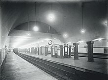
Government Center station is an MBTA subway station in Boston, Massachusetts. It is located at the intersection of Tremont, Court and Cambridge Streets in the Government Center area. It is a transfer point between the light rail Green Line and the rapid transit Blue Line. With the Green Line platform having opened in 1898, the station is the third-oldest operating subway station in the MBTA system; only Park Street and Boylston are older. The station previously served Scollay Square before its demolition for the creation of Boston City Hall Plaza.

<span class="mw-page-title-main">State station</span> Subway station in Boston, Massachusetts, US

State station is an underground Massachusetts Bay Transportation Authority (MBTA) rapid transit station located in downtown Boston, Massachusetts. It is the transfer point between the Orange Line and the Blue Line, and one of four "hub stations" on the MBTA subway system. The Orange Line has two side platforms on two levels, while the Blue Line has two side platforms on a single level. The station is fully accessible.

<span class="mw-page-title-main">Haymarket station (MBTA)</span> Subway station in Boston, Massachusetts, US

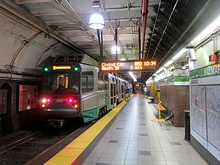
Haymarket station is an underground Massachusetts Bay Transportation Authority (MBTA) rapid transit station located at Haymarket Square in Boston, Massachusetts. It is a transfer station between the Green Line and Orange Line of the MBTA subway system, as well as a terminal for MBTA bus routes serving northern and northeastern suburbs. The two lines run parallel to each other through the station, with two side platforms for the Orange Line and a single island platform for the Green Line. The station is fully accessible.

<span class="mw-page-title-main">Boylston station</span> Subway station in Boston, Massachusetts, US

Boylston station is a light rail station on the MBTA Green Line in downtown Boston, Massachusetts, located on the southeast corner of Boston Common at the intersection of Boylston Street and Tremont Street. A southbound street-level stop for the SL5 route of the bus rapid transit Silver Line is outside fare control. The station has two island platforms; each has one disused track, making them effectively side platforms. Boylston is not accessible for Green Line trains.

<span class="mw-page-title-main">Aquarium station (MBTA)</span> Subway station in Boston, Massachusetts, US

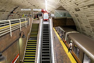
Aquarium station is an underground rapid transit station on the MBTA Blue Line in Boston, Massachusetts, United States. It is located under State Street at Atlantic Avenue on the eastern edge of Boston's Financial District near Boston Harbor. The station is named for the nearby New England Aquarium. It is adjacent to Long Wharf, which is used by two MBTA Boat lines. The station has two side platforms serving the two tracks of the Blue Line; an arched ceiling runs the length of the platform level. With the platforms 50 feet (15 m) below street level, it is the second-deepest station on the MBTA system.

<span class="mw-page-title-main">Lechmere station</span> Light rail station in Cambridge, Massachusetts, US

Lechmere station is a Massachusetts Bay Transportation Authority (MBTA) Green Line light rail station in Lechmere Square in East Cambridge, Massachusetts. It is located on the east side of Monsignor O'Brien Highway near First Street, adjacent to the NorthPoint development. The accessible elevated station has a single island platform, with headhouses at both ends. It opened on March 21, 2022, as part of the Green Line Extension (GLX). Lechmere station is served by Green Line D branch and E branch service.

<span class="mw-page-title-main">Hynes Convention Center station</span> Subway station in Boston, Massachusetts, US

Hynes Convention Center station is an underground light rail station on the Massachusetts Bay Transportation Authority (MBTA) Green Line. It is located at the intersection of Newbury Street and Massachusetts Avenue near the western end of the Back Bay neighborhood of Boston, Massachusetts. The station is named for the Hynes Convention Center, which is located about 700 feet (210 m) to the east along Boylston Street. It has two side platforms serving the two tracks of the Boylston Street subway, which are used by the Green Line B branch, C branch, and D branch. The main entrance to the station from Massachusetts Avenue leads to a fare lobby under the 360 Newbury Street building.

<span class="mw-page-title-main">Green Line B branch</span> Light rail line in Boston, Massachusetts

The B branch, also called the Commonwealth Avenue branch or Boston College branch, is a branch of the MBTA Green Line light rail system which operates on Commonwealth Avenue west of downtown Boston, Massachusetts. One of four branches of the Green Line, the B branch runs from Boston College station down the median of Commonwealth Avenue to Blandford Street. There, it enters Blandford Street portal into Kenmore station, where it merges with the C and D branches. The combined services run into the Boylston Street subway and Tremont Street subway to downtown Boston. B branch service has terminated at Government Center since October 2021. Unlike the other branches, the B branch runs solely through the city limits of Boston. The Green Line Rivalry between Boston College and Boston University is named in reference to the B branch, which runs to both universities.

<span class="mw-page-title-main">Maverick station</span> Subway station in Boston, Massachusetts, US

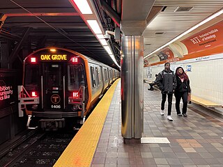
Maverick station is a rapid transit station in Boston, Massachusetts. It serves the MBTA's Blue Line and is located at Maverick Square in East Boston. It is the easternmost underground station on the Blue Line and a transfer point to various buses. A center island platform provides access to the surface in the middle of Maverick Square. In the station, a track map lined with light bulbs shows the position of the trains on the Blue Line between Bowdoin and Orient Heights. It was one of the last stations to be converted to 6-car train service as part of the MBTA's Blue Line Renovation Project. Maverick is a terminal for MBTA bus routes 114, 116, 117, 120, and 121.

<span class="mw-page-title-main">Sullivan Square station</span> Rapid transit station in Boston, Massachusetts, US

Sullivan Square station is a rapid transit station on the MBTA subway Orange Line, located adjacent to Sullivan Square in the Charlestown neighborhood of Boston, Massachusetts. It is a major transfer point for MBTA bus service, with 12 routes using a two-level busway. The station has two island platforms serving the two active Orange Line tracks plus an unused third track. The Haverhill Line and Newburyport/Rockport Line pass through the station on separate tracks but do not stop.

<span class="mw-page-title-main">Tremont Street subway</span> Boston subway tunnel

The Tremont Street subway in Boston's MBTA subway system is the oldest subway tunnel in North America and the third-oldest still in use worldwide to exclusively use electric traction, opening on September 1, 1897. It was originally built, under the supervision of Howard A. Carson as chief engineer, to get streetcar lines off the traffic-clogged streets, instead of as a true rapid transit line. It now forms the central part of the Green Line, connecting Boylston Street to Park Street and Government Center stations.

<span class="mw-page-title-main">Chinatown station (MBTA)</span> Subway station in Boston, Massachusetts, US

Chinatown station is a rapid transit station on the Massachusetts Bay Transportation Authority (MBTA) Orange Line, located at the edge of the Chinatown neighborhood in the downtown core of Boston, Massachusetts. The station has two offset side platforms, which run under Washington Street from Hayward Place to Lagrange Street. The three entrances are located at the intersection of Washington Street with Essex and Boylston streets. Like all Orange Line stations, both the subway platforms and all bus connections are fully accessible.

<span class="mw-page-title-main">Broadway station (MBTA)</span> Subway station in Boston, Massachusetts, US

Broadway station is a subway station in Boston, Massachusetts. It serves the MBTA's Red Line. It is located at the intersection of Dorchester Avenue and Broadway in South Boston. It was opened on December 15, 1917, as part of the Dorchester Extension from Downtown Crossing to Andrew. The station has a single island platform to serve the two tracks.

<span class="mw-page-title-main">North Station (subway)</span> Rapid transit station in Boston, Massachusetts, US

North Station is an underground MBTA subway station in Boston, Massachusetts. Served by the Massachusetts Bay Transportation Authority (MBTA) Green Line and Orange Line, it is connected to the North Station surface terminal used by MBTA Commuter Rail and Amtrak. The station is fully accessible.

References

  1. 1 2 "A Guide to Ridership Data". MassDOT/MBTA Office of Performance Management and Innovation. June 22, 2020. p. 6.
  2. Most, Doug (January 26, 2014). "The bigger dig". The Boston Globe . Retrieved April 6, 2024.
  3. 1 2 3 4 5 6 7 8 9 10 Belcher, Jonathan. "Changes to Transit Service in the MBTA district" (PDF). Boston Street Railway Association.
  4. 1 2 Coburn, Frederick W. (November 1910). "Rapid Transit and Civic Beauty". New Boston. Vol. 1, no. 7. pp. 307–314 via Google Books.
  5. Rettig, Polly M. (June 14, 1976). "National Register of Historic Places Inventory – Nomination Form: Tremont Street Subway". National Park Service.
  6. 1 2 "Signalmen of the Subway". Boston Globe. July 25, 1915. p. 25 via Newspapers.com. Open Access logo PLoS transparent.svg
  7. 1 2 3 4 5 Clarke, Bradley H. & Cummings, O.R. (1997). Tremont Street Subway: A Century of Public Service. Boston Street Railway Association. pp. 43, 49. ISBN   0938315048.
  8. 1 2 3 4 5 6 7 8 9 Chasson, George Jr. (1987). Lonto, Arthur J. (ed.). "Boston's Main Line El: The Formative Years 1879-1908". Headlights. 49. Electric Railroader's Association: 22–23.
  9. O'Regan, Gerry (2012). "MBTA Red Line". nycsubway.org. David Pirmann.
  10. Cudahy, Brian J. (1972). Change at Park Street Under . Stephen Greene Press. p. 47. ISBN   0828901732. LCCN   72081531.
  11. "Few Used New Bowdoin Sq Tunnel Immediately After its Opening". Boston Globe. March 18, 1916. p. 14 via Newspapers.com. Open Access logo PLoS transparent.svg
  12. "New Elevated Line to Open". Boston Globe. May 31, 1912. p. 18 via Newspapers.com. Open Access logo PLoS transparent.svg
  13. ""South Station Under" Opens Tomorrow". Boston Globe. December 2, 1916. p. 16 via Newspapers.com. Open Access logo PLoS transparent.svg
  14. "Will Use Part of the New Subway Sunday or Monday". Boston Globe. July 24, 1914. p. 9 via Newspapers.com. Open Access logo PLoS transparent.svg
  15. "New Boylston St Subway". Boston Globe. July 23, 1914. pp. 1, 4 via Newspapers.com. (second page) Open Access logo PLoS transparent.svg
  16. "Park-St Subway Station Now Has a Loud-Speaking Phone". Boston Globe. May 26, 1921. p. 1 via Newspapers.com. Open Access logo PLoS transparent.svg
  17. "'L' Information Booth in Park St Station". Boston Globe. December 15, 1923. p. 18 via Newspapers.com. Open Access logo PLoS transparent.svg
  18. Annual Report of the Public Trustees of the Boston Elevated Railway for the Year Ending December 31, 1923. Boston Elevated Railway. 1924. p. 8 via Internet Archive.
  19. "Many Injured in Explosion on Car in Park-St Subway". Boston Globe. January 3, 1925. p. 1 via Newspapers.com. Open Access logo PLoS transparent.svg
  20. Annual Report of the Transit Department for the Year Ending January 31, 1921. Boston Transit Department. 1921. p. 28 via Internet Archive.
  21. Annual Report of the Transit Department for the Year Ending January 31, 1922. City document No. 33A. Boston Transit Department. 1922. p. 25 via HathiTrust.
  22. "Open New Stairway at Park St This Week". Boston Globe. July 28, 1921. p. 7 via Newspapers.com. Open Access logo PLoS transparent.svg
  23. Annual Report of the Transit Department for the Year Ending January 31, 1923. Boston Transit Department. 1923. p. 4 via Internet Archive.
  24. Annual Report of the Transit Department for the Year Ending January 31, 1924. Boston Transit Department. 1924. pp. 30–31 via Internet Archive.
  25. Annual Report of the Transit Department for the Year Ending January 31, 1925. City document No. 33A. Boston Transit Department. 1925. p. 38 via HathiTrust.
  26. "Subway Changes at Park-St Station". Boston Globe. November 5, 1923. p. 14 via Newspapers.com. Open Access logo PLoS transparent.svg
  27. Annual Report of the Transit Department for the Year Ending December 31, 1925. Boston Transit Department. 1926. pp. 43–44 via Internet Archive.
  28. "Plan to Alleviate Park St Congestion". Boston Globe. July 30, 1922. p. 12 via Newspapers.com. Open Access logo PLoS transparent.svg
  29. "Foot Passage Under Tremont St for Subway Car Passengers". Boston Globe. October 24, 1922. p. 14 via Newspapers.com. Open Access logo PLoS transparent.svg
  30. "O'Hare Plan for Park-St Station Designed to End Jams both on Street and in Subway". Boston Globe. December 14, 1927. p. 17 via Newspapers.com. Open Access logo PLoS transparent.svg
  31. Report of the Transit Department for the Year Ending December 31, 1933. City of Boston. 1934. p. 3 via Internet Archive.
  32. 1 2 3 Eighteenth Annual Report of the Board of Trustees of the Boston Elevated Railway Company for the Year Ending December 31, 1936. Boston Elevated Railway. 1937. p. 16 via Internet Archive.
  33. Johnston, Louis; Williamson, Samuel H. (2023). "What Was the U.S. GDP Then?". MeasuringWorth . Retrieved November 30, 2023. United States Gross Domestic Product deflator figures follow the MeasuringWorth series.
  34. "Chapter 544: An act providing for the creation of the Metropolitan Transit Authority and the acquisition and operation by it of the entire assets, property and franchises of the Boston Elevated Railway Company". Acts and Resolves passed by the General Court of Massachusetts in the year 1947. Secretary of the Commonwealth. June 19, 1947. pp. 539–556 via Internet Archive.
  35. "You May Be Getting Off and On Subway Cars at Boston Common Station". Boston Globe. June 20, 1948. p. 92 via Newspapers.com. (second page) Open Access logo PLoS transparent.svg
  36. "Boston Common Garage to Be World's Biggest". Boston Globe. November 17, 1961. p. 20 via Newspapers.com. Open Access logo PLoS transparent.svg
  37. "MTA Duel Proves Clinker". Boston Globe. August 16, 1962. p. 10 via Newspapers.com. Open Access logo PLoS transparent.svg
  38. "Buy a Piece of Freedom Trail". Boston Globe. February 6, 1966. p. 78 via Newspapers.com. Open Access logo PLoS transparent.svg
  39. Cohen, Cathleen (October 2, 1966). "Freedom Trail Booth A Multi-Purpose Room". Boston Globe. p. 16 via Newspapers.com. Open Access logo PLoS transparent.svg
  40. 1 2 3 4 5 "Park Street Station". Boston Globe Calendar. August 27, 1992. pp. 12, 13 via Newspapers.com. (second page) Open Access logo PLoS transparent.svg
  41. Carr, Robert B. (July 26, 1972). "Park St. station facelift due". Boston Globe. p. 3 via Newspapers.com. Open Access logo PLoS transparent.svg
  42. Plotkin, A.S. (March 1, 1974). "4 downtown MBTA stops may be linked". Boston Globe. p. 5 via Newspapers.com. Open Access logo PLoS transparent.svg
  43. 1 2 Sanborn, George M. (1992). A Chronicle of the Boston Transit System. Massachusetts Bay Transportation Authority. Archived from the original on April 16, 2019 via Massachusetts Institute of Technology.
  44. Carr, Rpbert B. (May 24, 1974). "3 ultra-modern subway kiosks planned by MBTA at Park St". Boston Globe. p. 6 via Newspapers.com. Open Access logo PLoS transparent.svg
  45. 1979 Annual Report. Massachusetts Bay Transportation Authority. 1979. p.  27 via Internet Archive.
  46. Ackerman, Jerry (March 8, 1989). "T pressured to open all routes to disabled". Boston Globe. pp. 1, 16 via Newspapers.com. (second page, third page) Open Access logo PLoS transparent.svg
  47. 1985 Annual Report. Massachusetts Bay Transportation Authority. 1985. p.  13 via Internet Archive.
  48. 1984 Annual Report. Massachusetts Bay Transportation Authority. 1984. p.  22 via Internet Archive.
  49. 1986 Annual Report. Massachusetts Bay Transportation Authority. 1986. p.  23 via Internet Archive.
  50. Hartigan, Patti (October 1, 1987). "Sampling Boston's Daring, Ever-Evolving Avant-Garde Arts". Boston Globe. Calendar 8 via Newspapers.com.
  51. "Legal Notices". Boston Globe. March 12, 1991. p. 68 via Newspapers.com. Open Access logo PLoS transparent.svg
  52. "Field narrowed to 3 finalists for MBTA post". Boston Globe. July 11, 1991. p. 51 via Newspapers.com. Open Access logo PLoS transparent.svg
  53. Tran Systems and Planners Collaborative (August 24, 2007). "Evaluation of MBTA Paratransit and Accessible Fixed Route Transit Services: Final Report" (PDF). Massachusetts Bay Transportation Authority.
  54. Cullen, Kevin (June 23, 1992). "City Scenes". Boston Globe. p. 21 via Newspapers.com. Open Access logo PLoS transparent.svg
  55. "Rapid Transit". Ridership and Service Statistics (PDF) (11 ed.). Massachusetts Bay Transportation Authority. 2007. p. 30.
  56. Howe, Peter J. (March 3, 1990). "Plan razed for center on Common". Boston Globe. p. 21 via Newspapers.com. Open Access logo PLoS transparent.svg
  57. "Executive Summary" (PDF). Program of Mass Transportation. Boston Regional Metropolitan Planning Organization. January 2004. pp. 2–9. Archived from the original (PDF) on February 20, 2012.
  58. "U.S. Government Procurements". Commerce Business Daily. No. PSA-2843. May 8, 2001. p. 17 via Google Books.
  59. "Planned Accessibility Projects - On Board the Green Line". Massachusetts Bay Transportation Authority. Archived from the original on August 10, 2004.
  60. "MBTA Continues Light Rail Accessibility Program at Park Street Station" (Press release). Massachusetts Bay Transportation Authority. March 13, 2003. Archived from the original on April 17, 2003.
  61. "Light Rail Accessibility Program at Park Street Station Approaches Completion" (Press release). Massachusetts Bay Transportation Authority. July 25, 2003. Archived from the original on August 3, 2003.
  62. Smith, Kelly (December 21, 2012). "New elevators for America's first subway station" (Press release). Massachusetts Bay Transportation Authority.
  63. "Settlement Agreement" (PDF). Joanne Daniels-Finegold et al. v. MBTA. April 10, 2006. p. 18.
  64. "Notice to Bidders" (PDF). Park Street Station Wayfinding and Station Improvements. Massachusetts Bay Transportation Authority. January 23, 2019.
  65. Brelsford, Laura (May 26, 2020). "SWA Initiatives—May 2020" (PDF). p. 5.
  66. Aalto, Joanna; Dogra, Vikram (January 11, 2021). "Capital Program Update: FY21 Update through November 30, 2020" (PDF). Massachusetts Bay Transportation Authority. p. 14.
  67. "Downtown Crossing Accessibility Phase II: Virtual Public Meeting" (PDF). Massachusetts Bay Transportation Authority. October 25, 2021.
  68. "System-Wide Accessibility Initiatives—November 2023" (PDF). Massachusetts Bay Transportation Authority Department of System-Wide Accessibility. November 27, 2023. pp. 9–10.
  69. "2023–24 System Map". Massachusetts Bay Transportation Authority. December 17, 2023.
  70. "Park Street Station Neighborhood Map" (PDF). Massachusetts Bay Transportation Authority. April 2012. Archived from the original (PDF) on July 17, 2014.
  71. "Downtown Crossing Accessibility Phase II: Virtual Public Meeting" (PDF). Massachusetts Bay Transportation Authority. October 25, 2021.
  72. "On the Green Line" (PDF). Massachusetts Bay Transportation Authority.
  73. Annear, Steve (March 5, 2020). "MBTA sheds new light on Park Street station mural". Boston Globe.
  74. "On the Red Line" (PDF). Massachusetts Bay Transportation Authority.