
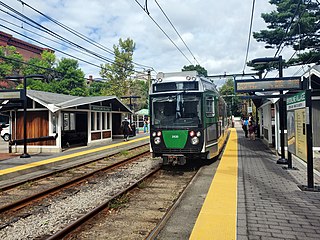
Boston College station is a light rail station on the MBTA Green Line B branch. It is located at St. Ignatius Square on the Boston College campus near the intersection of Commonwealth Avenue and Lake Street, on the border between the Brighton neighborhood of Boston and the Chestnut Hill neighborhood of Newton, Massachusetts. Originally opened in 1896, it has been the terminus of the Commonwealth Avenue line since 1900. The current station is planned to be replaced by a new station located in the median of Commonwealth Avenue just east of Lake Street.

The B branch, also called the Commonwealth Avenue branch or Boston College branch, is a branch of the MBTA Green Line light rail system which operates on Commonwealth Avenue west of downtown Boston, Massachusetts. One of four branches of the Green Line, the B branch runs from Boston College station down the median of Commonwealth Avenue to Blandford Street. There, it enters Blandford Street portal into Kenmore station, where it merges with the C and D branches. The combined services run into the Boylston Street subway and Tremont Street subway to downtown Boston. B branch service has terminated at Government Center since October 2021. Unlike the other branches, the B branch runs solely through the city limits of Boston. The Green Line Rivalry between Boston College and Boston University is named in reference to the B branch, which runs to both universities.

The Green Line D branch is a light rail line in Boston, Brookline, Cambridge, Newton, and Somerville, Massachusetts, operating as part of the Massachusetts Bay Transportation Authority (MBTA) Green Line. The line runs on a grade separated surface right-of-way for 9 miles (14 km) from Riverside station to Fenway station. The line merges into the C branch tunnel west of Kenmore, then follows the Boylston Street subway and Tremont Street subway to North Station. It is the longest and busiest of the four Green Line branches. As of February 2023, service operates on 8 to 9-minute headways at weekday peak hours and 8 to 11-minute headways at other times, using 13 to 19 trains.

The Highland branch, also known as the Newton Highlands branch, was a suburban railway line in Boston, Massachusetts. It was opened by the Boston and Albany Railroad in 1886 to serve the growing community of Newton, Massachusetts. The line was closed in 1958 and sold to the Metropolitan Transit Authority (MTA), the predecessor of the current Massachusetts Bay Transportation Authority (MBTA), which reopened it in 1959 as a light rail line, now known as the D branch of the Green Line.

The Framingham/Worcester Line of the MBTA Commuter Rail system runs west from Boston, Massachusetts to Worcester, Massachusetts through the MetroWest region, serving 17 station stops in Boston, Newton, Wellesley, Natick, Framingham, Ashland, Southborough, Westborough, Grafton, and Worcester. It is the third longest and third busiest line in the MBTA Commuter Rail system. Service on the line is a mix of local and express trains serving Worcester plus short-turn Framingham locals.

Waban station is a surface-level light rail station on the Massachusetts Bay Transportation Authority's Green Line D branch, located just south of Beacon Street at Waban Square in the Waban section of Newton, Massachusetts. The station is located below grade; access to both platforms is via Wyman Street on the outbound side of the tracks or a stairway from Beacon Street. Waban is not accessible.

Fenway station is a light rail stop on the MBTA Green Line D branch, located under Park Drive near the Riverway in the Fenway–Kenmore neighborhood of Boston, Massachusetts. It opened along with the rest of the D branch on July 4, 1959, when trolleys replaced Highland branch commuter rail service. The station is fully accessible from Park Drive via the Landmark Center parking lot, as well as from Miner Street. Named after the Fenway parkway rather than Fenway Park, it is further from the stadium than Kenmore, though still used during events.
Brookline Village station is a light rail station on the MBTA Green Line D branch, located in the Brookline Village neighborhood of Brookline, Massachusetts, United States. It was originally a commuter rail station on the Boston and Albany Railroad's Highland branch; it closed with the rest of the line in 1958 and reopened on July 4, 1959 as a light rail station. With 3,230 daily boardings, it is the third-busiest surface station on the D branch and the sixth-busiest surface station overall. Brookline Village station has raised platforms for accessibility with low-floor light rail vehicles.

Beaconsfield is an MBTA light rail station in Brookline, Massachusetts. It serves the Green Line D branch. It is located off Dean Road and Beaconsfield Road just south of Beacon Street. Like the other stops on the line, it was a commuter rail station on the Boston and Albany Railroad's Highland branch until 1958, when the line was closed and converted to a branch of what is now the Green Line. The station reopened along with the rest of the line in 1959.

Natick Center station is an MBTA Commuter Rail station in Natick, Massachusetts served by the Framingham/Worcester Line. The station, located below grade in a wide cut adjacent to North Main Street, has two side platforms serving the line's two tracks. The second-busiest non-accessible station on the system, it is undergoing a major accessibility renovation and modernization from 2020 to 2024.

Eliot station is a light rail station on the MBTA Green Line D branch located just north of Route 9 between the Newton Highlands and Newton Upper Falls villages of Newton, Massachusetts. The station has a parking lot at the end of Lincoln Street, a pedestrian entrance from Meredith Avenue, and pedestrian entrances from both sides of Route 9. A footbridge, built in 1977, crosses Route 9 adjacent to the railroad bridge.

Newton Highlands station is a surface-level light rail station located in Newton, Massachusetts on the Green Line D branch of the Massachusetts Bay Transportation Authority.

Brookline Hills station is a light rail station on the Massachusetts Bay Transportation Authority (MBTA) Green Line D branch in the Brookline Hills neighborhood of Brookline, Massachusetts. The station has two side platforms serving the line's two tracks. It was closed from April 2021 to January 2022 as part of adjacent construction on a Brookline High School building, which included renovations to make the station accessible.

Newtonville station is a commuter rail station on the MBTA Commuter Rail Framingham/Worcester Line, located between the Massachusetts Turnpike and Washington Street at Newtonville Square in the village of Newtonville in Newton, Massachusetts. Stairway entrances are located on the bridges over the Turnpike at Walnut Street and Harvard Street. Newtonville station is not accessible; renovations for accessibility are planned.

West Newton station is an MBTA Commuter Rail station in Newton, Massachusetts. It serves the Framingham/Worcester Line, and is located inside the Massachusetts Turnpike Exit 16 rotary in the village of West Newton. West Newton has had continuous rail service since 1834. The station consists of a single low side platform serving one of the line's two tracks, with small crossings to access trains on the far track. West Newton is not accessible; a renovation for accessibility is planned.

Auburndale station is an MBTA Commuter Rail station in Auburndale, Massachusetts. It serves the Framingham/Worcester Line. It is located next to the Massachusetts Turnpike near Lasell College. The modern station platform, built around 1961, replaced a highly acclaimed 1881 depot building designed by H. H. Richardson. A full renovation of the station for accessibility is planned.

South Street station is a light rail surface stop on the MBTA Green Line B branch, located in the median of Commonwealth Avenue east of South Street in the Brighton neighborhood of Boston, Massachusetts. South Street is the lowest-ridership stop on the B branch, with just 214 daily boardings by a 2011 survey.

Chestnut Hill Avenue station is a light rail surface stop on the MBTA Green Line B branch, located in the median of Commonwealth Avenue just east of Chestnut Hill Avenue in the Brighton neighborhood of Boston, Massachusetts. Chestnut Hill Avenue has two low-level platforms, serving the B branch's two tracks; the stop is not accessible.

Amory Street station is a light rail stop on the Massachusetts Bay Transportation Authority (MBTA) Green Line B branch, located in the median of Commonwealth Avenue in the west part of the Boston University campus. The accessible station has two side platforms serving the line's two tracks, with access at Amory Street and St. Paul Street.

Union Station is a railway station located at Washington Square in downtown Worcester, Massachusetts. It is the western terminus of the MBTA Commuter Rail Framingham/Worcester Line and a stop for the Amtrak Lake Shore Limited service. A bus terminal adjacent to the station is the hub for Worcester Regional Transit Authority (WRTA) local bus service; it is also used by PVTA, MART, Peter Pan, and Greyhound intercity buses.


