Green Line A branch

Last updated

Green Line A branch
MBTA 3109 on Cambridge Street, September 1968.jpg
An A branch streetcar on Cambridge Street in 1968
Overview
StatusAbandoned
Locale Boston, Newton, and Watertown
Termini
Service
Type Light rail
System Green Line (MBTA subway)
Operator(s) MBTA (at time of closure)
Rolling stock PCC streetcars (at time of closure)
History
ClosedJune 20, 1969
Technical
Line length7.3 miles (11.7 km)
Number of tracks2
Track gauge 4 ft 8+12 in (1,435 mm)
Route map

Contents

BSicon utCONTg.svg
BSicon utBHF.svg
Park Street
BSicon utBHF.svg
Boylston
BSicon uetABZgl.svg
BSicon uexCONTfq.svg
BSicon PORTALr.svg
BSicon utBHF.svg
Arlington
BSicon utBHF.svg
Copley
BSicon utABZgl.svg
BSicon utdCONTfq.svg
BSicon utBHF.svg
Auditorium
BSicon utBHF.svg
Kenmore
BSicon utdABZg2.svg
BSicon utdSTRc3.svg
BSicon utdSTRc1.svg
BSicon utdSTR.svg
BSicon utvSTR+4-.svg
BSicon ulCONTf2.svg
BSicon utSTR2+4.svg
BSicon utSTR~L.svg
BSicon utCONTf.svg
BSicon utSTR~R.svg
BSicon utSTRe.svg
Blandford Street Portal
BSicon uHST.svg
Blandford Street
BSicon uHST.svg
Granby Street
BSicon uHST.svg
St. Mary's Street
BSicon ueHST.svg
University Road
BSicon uHST.svg
Amory Street
BSicon uHST.svg
St. Paul Street
BSicon ulv-HST@F.svg
BSicon uev-SHI2gr.svg
Pleasant Street
BSicon uev-SHI2g+r.svg
BSicon uexvWSLe.svg
Braves Field Loop
closed 1962
BSicon ueHST.svg
Alcorn Street
BSicon uxABZgl.svg
BSicon udCONTfq.svg
BSicon uexHST.svg
Packards Corner
BSicon uexHST.svg
St. Luke's Street
BSicon uexHST.svg
Chester Street
BSicon uexHST.svg
Linden Street
BSicon uexHST.svg
Harvard Avenue
BSicon uexHST.svg
Allston Street
BSicon uexHST.svg
Union Square
BSicon uexLSTR.svg
BSicon RP4.svg
Cambridge Street
street-running stops
BSicon uexLSTR.svg
BSicon RP4.svg
BSicon uexlv-HST@F.svg
BSicon uexv-SHI2gr.svg
Oak Square
BSicon uexv-STR.svg
BSicon uexvWSLe.svg
Oak Square Loop
BSicon uexLSTR.svg
BSicon RP4.svg
BSicon uexHST.svg
Newton Corner
BSicon uexLSTR.svg
BSicon RP4.svg
Galen Street
street-running stops
BSicon uexKBHFe.svg
Watertown Yard

The A branch or Watertown Line was a streetcar line in the Boston, Massachusetts, area, operating as a branch of the Massachusetts Bay Transportation Authority Green Line. The line ran from Watertown through Newton Corner, Brighton, and Allston to Kenmore Square, then used the Boylston Street subway and Tremont Street subway to reach Park Street station.

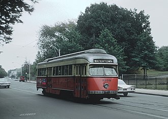
Portions of the route were built as horsecar lines between 1858 and 1880. The segment between Union Square and Oak Square was electrified in 1889 as part of the Beacon Street line. By 1896, electric routes ran from Newton Corner (Nonantum Square) to downtown Boston via Brighton and via Watertown. Brighton service was extended to Watertown in 1912. The line was operated until 1969, when it was replaced by MBTA bus route 57, though it remained in service for non-revenue moves to Watertown Yard until 1994.

History

Formation

1967 map of branches of the newly named Green Line, showing the "A" branch Green Line branches.jpg
1967 map of branches of the newly named Green Line, showing the "A" branch

Construction of the Brighton Horse Railroad, a horse car street railway, began in 1858. [1] The line began at Central Square, Cambridge, and crossed the Charles River on the River Street bridge into Allston. It continued through Union Square along Cambridge Street and Washington Street to Oak Square in the center of Brighton. The line was operated by the Union Street Railway, a holding company for the Cambridge Railroad system. After a dispute with the Boston and Worcester Railroad over the right to cross their tracks, the line opened on November 15, 1858. [2] [3] :48 Service was doubled in April 1878, with cars operating every half hour. [4] In 1880, the company opened a second Brighton–Cambridge line via Market Street and Western Avenue. [5] A planned extension that year from Oak Square to Nonantum Square was not built, though a line from Watertown to Nonantum Square was. [6] [7]

In the late 1880s, the West End Street Railway consolidated the horse railroads, including the Cambridge Railroad, under its control. The West End opened its first electric streetcar line on January 3, 1889. The line ran between the Allston Carhouse (just north of Union Square) and Park Square via Harvard Street, Beacon Street, Massachusetts Avenue, and Boylston Street. Electric service was extended to Oak Square on January 13. [3] :48 Electric service between Watertown and Mount Auburn began on December 12, 1893; the line was double-tracked later in the decade. [8] [9] [10] On August 18, 1896, the Western Avenue line was double-tracked and electrified. [11] It was the last line that ran over the West Boston Bridge to be electrified; until then, its cars were hauled by horses to Central Square, then attached to electric cars from Allston for the remainder of the trip into Boston. [12] [13] [14]

On May 18, 1896, tracks opened from Union Square east along North Beacon Street and Commonwealth Avenue to Kenmore Square, merging with the existing tracks on Beacon Street. On June 13, the western terminal was also extended to just shy of Newton Corner (Nonantum Square). On November 8, 1897, Newton service via Commonwealth Avenue began running into the Tremont Street subway. [15] A lengthy Nonantum Square–City Point route via Allston, Coolidge Corner, and Park Square opened on August 4, 1900. [16] On December 9, 1912, service was extended north to Watertown on the existing Galen Street tracks. [17] During the early part of the 20th century, the line was also used for freight service. [18]

The Boylston Street subway was opened to an incline in Kenmore Square on October 3, 1914, with Watertown service via Brighton Center immediately routed into the new tunnel. [19] The first use of high-capacity center-entrance streetcars on the BERy system was as trailers on the Watertown Line in mid-1915. [20] On February 23, 1922, Oak Square short turns were extended to Watertown in the evening peak hour. [21] The Blandford Street portal, on Commonwealth Avenue west of Kenmore, opened October 23, 1932, marking the last change in the route of the service. In 1941, the line became the first line in Boston to have primary service with the new PCC streetcars, which replaced the Types 4 and 5 cars then in service. [18]

North Beacon Street line

A 1910 postcard of two streetcars at the Public Garden incline. The left car is bound for Watertown via North Beacon Street; the right is bound for Park Street from Union Square. Public Garden Incline 1910 postcard.jpg
A 1910 postcard of two streetcars at the Public Garden incline. The left car is bound for Watertown via North Beacon Street; the right is bound for Park Street from Union Square.

In June 1894, the West End applied for city permission to construct a line on North Beacon Street between Union Square and the Watertown border. [22] The Newtonville and Watertown Street Railway soon secured position to build between Watertown Square and Union Square, with the intention to use the West End tracks to reach downtown Boston. After approval by the Watertown Arsenal (which owned a section of North Beacon Street) in 1896 – despite the objection of the West End – the company constructed the line in 1898. [23] [24] [25]

After further disagreements between its parent company Newton and Boston Street Railway and the BERy about operations, the line opened in 1900. [26] [27] [28] :195 Through service on the line between Watertown and the Tremont Street subway, acting as a branch of the Newton-Brighton line, began on November 18, 1900. [29] The BERy took over the line from the Newton and Boston in 1907. [28] :195 The portion west of Market Street was among the only BERy lines never to be double-tracked. [30] [31] [32]

The Newton Street Railway (later the Middlesex and Boston Street Railway) began Waltham–Park Street service via the North Beacon Street line on February 23, 1903. [3] :39 This service was rerouted to Central Square on April 27, 1912, running on Arsenal Street and Western Avenue rather than North Beacon Street. Oak Square–Boston service via Western Avenue was also cut to an Oak Square–Central Square route, and later to a Union Square–Central Square route. Watertown–Park Street service via North Beacon Street remained. [33] Upon the opening of the Boylston Street subway in October 1914, North Beacon Street service was cut to a Watertown–Union Square shuttle. [19] It was further cut to a North Beacon Street bridge (the Brighton/Watertown line) – Union Square shuttle on June 2, 1917. [34]

The North Beacon Street shuttle was replaced with a bus route on February 23, 1922. [21] A Watertown–Arsenal Street bridge bus route, which ran on North Beacon between Watertown and School Street, was briefly run in 1925–26. [28] :50 The Central Square–Union Square line was rerouted via Western Avenue and Soldiers Field Road on December 14, 1925, with a new bus route on River Street. [35] The bus route was extended to Union Square on September 11, 1926, replacing the streetcar line. [36] The two bus routes were combined in February 1933 to eliminate the transfer; the route is now the route 64 bus. [37] [38]

Closure

The A branch ran in mixed traffic for much of its length, causing it to be slow and unreliable. MBTA 3137 boarding passengers at St. Elizabeth's Hospital, September 1968.jpg
The A branch ran in mixed traffic for much of its length, causing it to be slow and unreliable.

Prior to 1967, when the current letters were assigned to the Green Line's branches, the Watertown Line was route 69. (Route 57, the line's current number, was originally assigned to Heath Street short-turn trips on the Huntington Avenue line.) The line was assigned the letter "A" because it was the northernmost branch. Turnback loops existed at Union Square (via Cambridge Street and Harvard Avenue) and Oak Square, as well as the Watertown terminal. Additionally, from 1915 to January 15, 1962, a loop existed at Braves Field, for special events along the part of the line concurrent with the Commonwealth Avenue line. [39]

The opening of the Riverside Line in 1959 caused streetcar lines in Cambridge running out of Harvard Square to be converted to trackless trolley, and the newly freed PCC streetcars were reassigned to the Riverside branch. However, the 1940s-era PCC fleet was aging, and maintaining five different types of PCCs complicated mechanical work. [40] By the late 1960s, wear and tear and a lack of replacements caused a shortage of Green Line streetcars, and the MBTA announced the closure of the A branch on a "trial" basis. [40] [41]

The A branch was chosen for closure because much of its route consisted of street running sections from Watertown to Packards Corner, and in 1964 there had been objections to keeping the service past Newton Corner. [18] Streetcars last ran on June 20, 1969, with the route 57 bus beginning the next day.

Track removal

Former stub remains of A branch tracks at Packards Corner. The switch was disconnected in 2014 and paved over in 2020. Green Line A Branch, disconnected switch, September 2014.jpg
Former stub remains of A branch tracks at Packards Corner. The switch was disconnected in 2014 and paved over in 2020.

The legacy tracks remained after 1969, being used for several decades to allow Green Line streetcars to reach the Watertown Carhouse for maintenance. The last use of the line was in 1993, when the fleet of PCC streetcars used for the Ashmont–Mattapan high-speed line was refurbished at the Watertown carhouse. [18] The electrified overhead wire was finally removed in March 1994. [39]

Additional overhead infrastructure, as well as the tracks themselves, were mainly removed by the end of the summer of 1996 as part of a resurfacing project on North Beacon Street. Remnants of the tracks are still visible today in the Watertown Yard bus terminal (no longer used for railcar maintenance), as well as a short stub track at Packard's Corner, where the "A" branch used to diverge from the "B" branch. The stub, part of the former outbound track, was used for temporarily storing disabled trains until it was shorted to just a few feet long in the mid 2000s; the switch was not disconnected until 2014 and not paved over until 2020.

Restoration of the "A" branch was advocated to provide a one-seat ride to downtown Boston from the northern corridor (rather than requiring a transfer at Kenmore), but was ruled too costly and less safe compared to the replacement bus service. [41]

Bus routes

Route 57

57
MBTA route 57 bus at Union Square, July 2021.jpg
A route 57 bus at Union Square, Allston, in July 2021
Overview
System MBTA bus
GarageAlbany Street Garage [42]
Route
Locale Boston, Newton, and Watertown, Massachusetts
Start Watertown Yard
End Kenmore station
Length5.8 miles (9.3 km) eastbound
5.4 miles (8.7 km) westbound
Daily ridership10,560 (2018) [43]

The 57 Watertown Yard–Kenmore station bus was initiated in 1969 as replacement service for the A branch. The 57 follows the same routing from Watertown Yard to Kenmore except for the Newton Corner rotary, where inbound buses follow traffic rather than operating in a counterflow lane as streetcars had. As a way to make the service more attractive, the MBTA originally had the 57 operate as a limited (boarding-only outbound and dropoff-only inbound) between Packards Corner and Kenmore, with the "B" branch providing local service along Commonwealth Avenue. In December 2006 the 57 began making local stops on Commonwealth. [39]

Since free transfers had been previously eliminated by the M.T.A. in October 1961, Watertown riders had to pay a double fare to continue downtown after the bustitution. This continued until January 1, 2007, when a new fare structure added free transfers when using a CharlieCard. [44]

Additional short turn trips between Oak Square and Kenmore at rush hour were cut in June 1971, and restored for mornings only in 1987. Morning-only Brighton Center–Kenmore trips were operated from September 1999 to June 2013. [39] On September 1, 2008, due to overcrowding on the inner part of the route, the MBTA began operating the 57A Oak Square–Kenmore station short turn of the 57 during weekday rush hours. [39] [45] [46] Approximately every other trip operated as a 57A during rush hours; during off-peak hours and weekends all buses ran the full-length route. Oak Square short turn service was discontinued in December 2020 except for a small number of school-day trips; frequency on the full route was increased. [39]

Route 57 operates as a busy key bus route, with headways between 10 and 12 minutes at all times (and equal headways on the 57A during peaks). As of 2012, the 57 and 57A combined were ninth-busiest route on the MBTA system, with 10,094 boardings on an average weekday. [42] Route 57 is based at the Albany Street Bus Facility during weekday rush hours and midday service, and is based at the Cabot Garage for evening, weekend, and holiday service. [42] One early-morning round trip, intended for MBTA employees but open to the public, continues to Haymarket. It was inaugurated along with several other routes by the M.T.A. in September 1960, though they were not listed in public timetables until September 1999. The trip is internally called route 191, but is shown on public timetables as a route 57 trip. [39]

A 2018–19 MBTA review of its bus system found that route 57 suffered from overcrowding at peak hours and poor reliability. [47] No short-term changes were recommended. [48] 2022 MBTA proposals for its systemwide bus network redesign called for the 57 to have increased frequency to provide service every 15 minutes or better at all operating hours. [49] [50]

Express buses

A route 501 bus in Brighton Center in 2016 MBTA route 501 bus in Brighton Center, August 2016.JPG
A route 501 bus in Brighton Center in 2016

The portion of the route west of Brighton Center is also served by two express routes, which operate to downtown Boston via Copley Square:

  • 501 Brighton Center–Federal Street & Franklin Street
  • 504 Watertown Yard–Federal Street & Franklin Street

Express bus service from Brighton and Watertown began even while the "A" branch was still running. The 61 Watertown/Newton Corner-Downtown Boston via Mass. Turnpike route began in July 1967, with Saturday service added in March 1968. In December 1967, the 61 was renumbered as 4, and a new route 61 running from Oak Square to downtown via Brighton Center and Union Square, Boston and the Turnpike was initiated. [39] In September 1968, the 61 was changed to originate at Brighton Center, from where it ran through Oak Square and entered the Turnpike at Newton Corner. Route 62 Watertown-Copley was started at the same time. [39]

In June 1970, the routes were renumbered from 4, 61, and 62 to 304, 301, and 302 to reflect their express routings. (The 300-series numbers had been used by ex-Eastern Massachusetts Street Railway bus routes in Lawrence, briefly under MBTA control, in 1968). [39] In March 1974, route 301 buses operating opposite the peak direction began using the pre-1968 routing on Cambridge Street. Inbound morning buses reverted to the Newton Corner routing in June 1974, but outbound afternoon buses continued to travel via Union Square. Some afternoon buses switched back to the Cambridge Street route in September 1976 and September 1978. [39]

All three routes had a number of minor changes to their downtown and Copley Square routings in the late 1970s and 1980s. Midday and Saturday service on the 302 began in January 1983; in December 1989, the midday and Saturday buses added a Copley Square stop as route 304 Watertown-Downtown via Copley. [39] In September 1996, the routes were renumbered as the 501, 502, and 504. [39] In January 2005, the 503 Brighton Center–Copley Square route was inaugurated. Inbound route 503 afternoon trips began operating via Cambridge Street in March 2014; route 501 followed suit in March 2019. [39]

The 2018–19 system review found that routes 501 and 503 had too-close stop spacing on the outer section of the route, inconsistent afternoon peak schedules, and poor reliability. [51] [52] No major issues were found with routes 502 and 504. [53] The MBTA recommended that outbound route 502 and 504 buses operate directly to Galen Street, rather than looping the Newton Corner rotary to serve those stops. [48] This was implemented on September 1, 2019; outbound route 501 and 503 buses began serving the Newton Corner stops at that time. [54]

Most MBTA service began operating on Saturday schedules on March 17, 2020, due to the COVID-19 pandemic. Weekday-only routes 502 and 503 were suspended, while routes 501 and 504 operated on reduced schedules. Route 504 began operating via Copley on most trips – operating on surface streets between Copley Square and downtown Boston – to replace route 502. It also resumed looping around Newton Corner on outbound trips. [39] [55] Route 501 was suspended from June 2020 to August 31, 2020; upon its return, it began serving Copley Square as well. [56] [57] The May 2022 network proposals called for the 2020 changes to be made permanent, and for routes 501 and 504 to only operate at weekday peak hours. A November 2022 revision re-added midday service on route 504. [58] [49] [50]

Map

Green Line A Branch map.svg

Related Research Articles

<span class="mw-page-title-main">Green Line (MBTA)</span> Light rail system

The Green Line is a semi-metro system run by the Massachusetts Bay Transportation Authority (MBTA) in the Boston, Massachusetts, metropolitan area. It is the oldest MBTA subway line, and with tunnel sections dating from 1897, the oldest subway in North America. It runs underground through downtown Boston, and on the surface into inner suburbs via six branches on radial boulevards and grade-separated alignments. With an average daily weekday ridership of 137,700 in 2019, it is the third most heavily used light rail system in the country. The line was assigned the green color in 1967 during a systemwide rebranding because several branches pass through sections of the Emerald Necklace of Boston.

<span class="mw-page-title-main">Kenmore station</span> Subway station in Boston, Massachusetts, US

Kenmore station is a light rail station on the MBTA Green Line, located under Kenmore Square in the Fenway/Kenmore neighborhood of Boston, Massachusetts, United States. The station opened on October 23, 1932 as a one-station extension of the Boylston Street subway to relieve congestion in the square. Kenmore is the primary station for passengers wishing to visit Fenway Park, located one block away.

<span class="mw-page-title-main">MBTA bus</span> Greater Boston bus network

The Massachusetts Bay Transportation Authority (MBTA) operates 152 bus routes in the Greater Boston area. The MBTA has a policy objective to provide transit service within walking distance for all residents living in areas with population densities greater than 5,000 inhabitants per square mile (1,900/km2) within the MBTA's service district. Much of this service is provided by bus. In 2023, the system had a ridership of 91,459,700, or about 303,300 per weekday as of the fourth quarter of 2023.

<span class="mw-page-title-main">Boston College station</span> Light rail station in Boston, Massachusetts, US

Boston College station is a light rail station on the MBTA Green Line B branch. It is located at St. Ignatius Square on the Boston College campus near the intersection of Commonwealth Avenue and Lake Street, on the border between the Brighton neighborhood of Boston and the Chestnut Hill neighborhood of Newton, Massachusetts. Originally opened in 1896, it has been the terminus of the Commonwealth Avenue line since 1900. The current station is planned to be replaced by a new station located in the median of Commonwealth Avenue just east of Lake Street.

<span class="mw-page-title-main">Lechmere station</span> Light rail station in Cambridge, Massachusetts, US

Lechmere station is a Massachusetts Bay Transportation Authority (MBTA) Green Line light rail station in Lechmere Square in East Cambridge, Massachusetts. It is located on the east side of Monsignor O'Brien Highway near First Street, adjacent to the NorthPoint development. The accessible elevated station has a single island platform, with headhouses at both ends. It opened on March 21, 2022, as part of the Green Line Extension (GLX). Lechmere station is served by Green Line D branch and E branch service.

<span class="mw-page-title-main">Hynes Convention Center station</span> Subway station in Boston, Massachusetts, US

Hynes Convention Center station is an underground light rail station on the Massachusetts Bay Transportation Authority (MBTA) Green Line. It is located at the intersection of Newbury Street and Massachusetts Avenue near the western end of the Back Bay neighborhood of Boston, Massachusetts. The station is named for the Hynes Convention Center, which is located about 700 feet (210 m) to the east along Boylston Street. It has two side platforms serving the two tracks of the Boylston Street subway, which are used by the Green Line B branch, C branch, and D branch. The main entrance to the station from Massachusetts Avenue leads to a fare lobby under the 360 Newbury Street building.

<span class="mw-page-title-main">MBTA key bus routes</span> Bus routes utilized and ran by the MBTA

Key bus routes of the Massachusetts Bay Transportation Authority (MBTA) system are 15 routes that have high ridership and higher frequency standards than other bus lines, according to the 2004 MBTA Service Policy. Together, they account for roughly 40% of the MBTA's total bus ridership. These key bus routes ensure basic geographic coverage with frequent service in the densest areas of Boston, and connect to other MBTA services to give access to other areas throughout the region.

The Middlesex and Boston Street Railway (M&B) was a streetcar and later bus company in the area west of Boston. Streetcars last ran in 1930, and in 1972, the company's operations were merged into the Massachusetts Bay Transportation Authority (MBTA).

<span class="mw-page-title-main">Newton and Boston Street Railway</span>

The Newton and Boston Street Railway was a streetcar company in the Boston, Massachusetts area, eventually bought by the Middlesex and Boston Street Railway. Its line is now the 59 Needham Junction – Watertown Square via Newtonville bus.

<span class="mw-page-title-main">Green Line E branch</span> Light rail line

The E branch is a light rail line in Boston, Cambridge, Medford, and Somerville, Massachusetts, operating as part of the Massachusetts Bay Transportation Authority (MBTA) Green Line. The line runs in mixed traffic on South Huntington Avenue and Huntington Avenue between Heath Street and Brigham Circle, in the median of Huntington Avenue to Northeastern University, then into the Huntington Avenue subway. The line merges into the Boylston Street subway just west of Copley, running to North Station via the Tremont Street subway. It then follows the Lechmere Viaduct to Lechmere, then the Medford Branch to Medford/​Tufts. As of February 2023, service operates on eight-minute headways at weekday peak hours and eight to nine-minute headways at other times, using 13 to 17 trains.

<span class="mw-page-title-main">Green Line C branch</span> Light rail line in Massachusetts, US

The C branch, also called the Beacon Street Line or Cleveland Circle Line, is one of four branches of the Massachusetts Bay Transportation Authority's Green Line light rail system in the Boston, Massachusetts metropolitan area. The line begins at Cleveland Circle in the Brighton neighborhood of Boston and runs on the surface through Brookline along the median of Beacon Street. Reentering Boston, the line goes underground through the St. Mary's Street incline and joins the B and D branches at Kenmore. Trains run through the Boylston Street subway to Copley where the E branch joins, then continue through the Tremont Street subway to downtown Boston. The C branch has terminated at Government Center station since October 2021.

<span class="mw-page-title-main">Green Line B branch</span> Light rail line in Boston, Massachusetts

The B branch, also called the Commonwealth Avenue branch or Boston College branch, is a branch of the MBTA Green Line light rail system which operates on Commonwealth Avenue west of downtown Boston, Massachusetts. One of four branches of the Green Line, the B branch runs from Boston College station down the median of Commonwealth Avenue to Blandford Street. There, it enters Blandford Street portal into Kenmore station, where it merges with the C and D branches. The combined services run into the Boylston Street subway and Tremont Street subway to downtown Boston. B branch service has terminated at Government Center since October 2021. Unlike the other branches, the B branch runs solely through the city limits of Boston. The Green Line Rivalry between Boston College and Boston University is named in reference to the B branch, which runs to both universities.

<span class="mw-page-title-main">Green Line D branch</span> Light rail line

The Green Line D branch is a light rail line in Boston, Brookline, Cambridge, Newton, and Somerville, Massachusetts, operating as part of the Massachusetts Bay Transportation Authority (MBTA) Green Line. The line runs on a grade separated surface right-of-way for 9 miles (14 km) from Riverside station to Fenway station. The line merges into the C branch tunnel west of Kenmore, then follows the Boylston Street subway and Tremont Street subway to North Station. It is the longest and busiest of the four Green Line branches. As of February 2023, service operates on 8 to 9-minute headways at weekday peak hours and 8 to 11-minute headways at other times, using 13 to 19 trains.

<span class="mw-page-title-main">Boston-area streetcar lines</span>

As with many large cities, a large number of Boston-area streetcar lines once existed, and many continued operating into the 1950s. However, only a few now remain, namely the four branches of the Green Line and the Ashmont–Mattapan High-Speed Line, with only one running regular service on an undivided street.

<span class="mw-page-title-main">86 (MBTA bus)</span> Bus route in Greater Boston

Route 86 is a local bus route in Boston, Cambridge, and Somerville, Massachusetts, operated by the Massachusetts Bay Transportation Authority (MBTA) as part of MBTA bus service. It operates on a circumferential route between Sullivan Square station and Reservoir station via Union Square, Somerville, Harvard Square, and Brighton Center. In 2018, it had the 18th-highest weekday ridership on the system, though it ranked 37th by number of weekday trips. A 2018–19 MBTA review of its bus system found that route 86 had infrequent and unreliable service, including irregular scheduled headways, despite its high ridership and significance as a crosstown connecting route.

<span class="mw-page-title-main">Watertown Yard</span> Boston MBTA former subway station

Watertown Carhouse is a bus maintenance facility and former streetcar carhouse located in the southern section of Watertown, Massachusetts, across the Charles River from Watertown Square. As Watertown Yard, the site also serves as a bus depot serving local and express routes, with additional connections available at Watertown Square on the opposite end of the Watertown Bridge.

<span class="mw-page-title-main">Babcock Street station</span> Light rail station in Boston, Massachusetts, US

Babcock Street station is a light rail stop on the Massachusetts Bay Transportation Authority (MBTA) Green Line B branch, located in the median of Commonwealth Avenue in the west part of the Boston University campus. The accessible station has two side platforms serving the line's two tracks, with access at Babcock Street and Pleasant Street.

<span class="mw-page-title-main">Amory Street station</span> Light rail station in Boston, Massachusetts, US

Amory Street station is a light rail stop on the Massachusetts Bay Transportation Authority (MBTA) Green Line B branch, located in the median of Commonwealth Avenue in the west part of the Boston University campus. The accessible station has two side platforms serving the line's two tracks, with access at Amory Street and St. Paul Street.

<span class="mw-page-title-main">Newton Corner station</span> Transit hub in Newton, Massachusetts, US

Newton Corner is an MBTA bus transfer point in the Newton Corner neighborhood of Newton, Massachusetts, located on the rotary where Washington Street crosses the Massachusetts Turnpike. The Newton Corner station, known simply as Newton for much of its lifetime, served commuters on the Worcester Line from 1834 to 1959. A streetcar stop, located on the surface streets, served a number of routes beginning in 1863, including the Green Line A branch until 1969. Newton Corner is now a stop and transfer point for MBTA routes 52, 57, 501, 504, 553, 554, 556, and 558, which include express routes to downtown Boston as well as local routes, with stops on the north and south sides of the rotary.

<span class="mw-page-title-main">Ipswich Street line</span> Former streetcar line in Boston and Brookline, Massachusetts

The Ipswich Street line was a streetcar line in Boston and Brookline, Massachusetts. The line ran on Boylston Street and Ipswich Street in the Fenway–Kenmore neighborhood, and on Brookline Avenue through what is now the Longwood Medical Area to Brookline Village.

References

  1. "General Intelligence". New England Farmer. January 23, 1858. p. 3 via Newspapers.com. Open Access logo PLoS transparent.svg
  2. "Miscellaneous Items". New England Farmer. September 18, 1858. p. 3 via Newspapers.com. Open Access logo PLoS transparent.svg
  3. 1 2 3 Clarke, Bradley H.; Cummings, O.R. (1997). Tremont Street Subway: A Century of Public Service. Boston Street Railway Association. ISBN   0938315048.
  4. "Brighton District". Boston Globe. April 30, 1878. p. 1 via Newspapers.com. Open Access logo PLoS transparent.svg
  5. "The Union Street Railway". Boston Globe. December 30, 1879. p. 4 via Newspapers.com. Open Access logo PLoS transparent.svg
  6. "Newton". Boston Globe. December 16, 1879. p. 4 via Newspapers.com. Open Access logo PLoS transparent.svg
  7. "Street Railways". Eighteenth Annual Report of the City Engineer for the Year Ending December 31, 1898. Graphic Press. 1899. p. 96 via Google Books.
  8. "Joined By Electric Bands". Boston Globe. December 12, 1893. p. 4 via Newspapers.com. Open Access logo PLoS transparent.svg
  9. "To Widen Mt Auburn Street". Boston Globe. December 10, 1894. p. 3 via Newspapers.com. Open Access logo PLoS transparent.svg
  10. "Newton". Boston Globe. June 1, 1896. p. 2 via Newspapers.com. Open Access logo PLoS transparent.svg
  11. Ninth Annual Report of the West End Street Railway Company for the Year Ending September 30, 1896. Walker, Young & Co. 1896. p. 7 via Internet Archive.
  12. "New Arrangements on the West End Road". Boston Globe. December 26, 1894. p. 2 via Newspapers.com. Open Access logo PLoS transparent.svg
  13. "New Electric Line". Boston Globe. April 9, 1895. p. 7 via Newspapers.com. Open Access logo PLoS transparent.svg
  14. "To Country and Beach". Boston Globe. August 13, 1896. p. 2 via Newspapers.com. Open Access logo PLoS transparent.svg
  15. "Subway Notice". Boston Globe. November 6, 1897. p. 2 via Newspapers.com. Open Access logo PLoS transparent.svg
  16. "New Electric Car Routes". Boston Globe. July 30, 1900. p. 12 via Newspapers.com. Open Access logo PLoS transparent.svg
  17. "To Watertown Car Barn". Boston Globe. December 7, 1912. p. 5 via Newspapers.com. Open Access logo PLoS transparent.svg
  18. 1 2 3 4 Moore, Scott. "The Watertown Line". NETransit. Archived from the original on February 3, 2002. Retrieved September 10, 2011.
  19. 1 2 "Changes Made by New Subway". Boston Globe. October 1, 1914. p. 3 via Newspapers.com. Open Access logo PLoS transparent.svg
  20. "'Trailers' to Relieve Rush-Hour Jam". Boston Globe. May 22, 1915. p. 4 via Newspapers.com. Open Access logo PLoS transparent.svg
  21. 1 2 "Extra "L" Service for Watertown and Newton". Boston Globe. February 22, 1922. p. 3 via Newspapers.com. Open Access logo PLoS transparent.svg
  22. "[Untitled]". Boston Globe. June 9, 1894. p. 8 via Newspapers.com. Open Access logo PLoS transparent.svg
  23. "Single Track Location". Boston Globe. August 25, 1896. p. 4 via Newspapers.com. Open Access logo PLoS transparent.svg
  24. "New Link for Electrics". Boston Globe. September 11, 1896. p. 12 via Newspapers.com. Open Access logo PLoS transparent.svg
  25. "Brighton". Boston Globe. June 20, 1898. p. 4 via Newspapers.com. Open Access logo PLoS transparent.svg
  26. "Watertown Will Not Delay". Boston Globe. January 26, 1899. p. 4 via Newspapers.com. Open Access logo PLoS transparent.svg
  27. "Watertown". Boston Globe. May 12, 1900. p. 5 via Newspapers.com. Open Access logo PLoS transparent.svg
  28. 1 2 3 Humphrey, Thomas J. (August 2020). "Origin and Development of the Fixed-Route Local Bus Transportation Network in the Cities and Towns of the Massachusetts Bay Transportation Authority District as of December 31, 1973: Revised Edition" (PDF). NETransit.
  29. "New Line to Park St Station". Boston Globe. November 17, 1900. p. 4 via Newspapers.com. Open Access logo PLoS transparent.svg
  30. Map of Boston and Vicinity showing tracks operated by the Boston Elevated Railway Co., Surface Lines, Boston Elevated Railway, August 1904 via Wikimedia Commons
  31. Tracks Operated by the Boston Elevated Railway Company, Boston Elevated Railway, January 1914 via Wikimedia Commons
  32. Mather, W. I. (1921), Boston Elevated Railway Lines, Boston Elevated Railway via Wikimedia Commons
  33. "To Connect at Subway". Boston Globe. April 25, 1912. p. 11 via Newspapers.com. Open Access logo PLoS transparent.svg
  34. "Changes in Service on Several Elevated Lines". Boston Globe. June 3, 1917. p. 16 via Newspapers.com. Open Access logo PLoS transparent.svg
  35. "Day and Night Cars Changes on Monday". Boston Globe. December 10, 1925. p. 17 via Newspapers.com. Open Access logo PLoS transparent.svg
  36. "Buses to Take Place of Allston-Central Sq Cars". Boston Globe. September 10, 1926. p. 8 via Newspapers.com. Open Access logo PLoS transparent.svg
  37. "Brighton District". Boston Globe. January 21, 1933. p. 11 via Newspapers.com. Open Access logo PLoS transparent.svg
  38. "Brighton District". Boston Globe. February 20, 1933. p. 9 via Newspapers.com. Open Access logo PLoS transparent.svg
  39. 1 2 3 4 5 6 7 8 9 10 11 12 13 14 15 Belcher, Jonathan. "Changes to Transit Service in the MBTA district" (PDF). Boston Street Railway Association.
  40. 1 2 Moore, Scott. "Boston's Green Line Crisis". NETransit. Archived from the original on February 22, 2007. Retrieved September 10, 2011.
  41. 1 2 St. Martin, Greg (June 21, 2009). "Where did the 'A' Line go, anyway?". Boston Metro. Archived from the original on May 3, 2010. Retrieved September 10, 2011.
  42. 1 2 3 "Ridership and Service Statistics" (PDF) (14th ed.). Massachusetts Bay Transportation Authority. 2014.
  43. "Route 57" (PDF). Massachusetts Bay Transportation Authority. December 2018.
  44. "Fares & Passes (effective January 2007)". Massachusetts Bay Transportation Authority. Archived from the original on January 27, 2007.
  45. Jacobi, Sara (September 11, 2008). "Residents split on proposed bus route changes". Wicked Local. Archived from the original on December 8, 2015.
  46. "Schedules and Maps: 57 – Watertown Yard–Kenmore Sta. via Newton Corner & Brighton Center..." Massachusetts Bay Transportation Authority. Archived from the original on September 9, 2008.
  47. "Route 57" (PDF). Massachusetts Bay Transportation Authority. December 2018.
  48. 1 2 "Better Bus Project Route Proposals" (PDF). Massachusetts Bay Transportation Authority. January 2019. p. 91.
  49. 1 2 "Draft Bus Network Redesign Map" (PDF). Massachusetts Bay Transportation Authority. May 2022.
  50. 1 2 "Revised Bus Network Fall 2022" (PDF). Massachusetts Bay Transportation Authority. November 3, 2022.
  51. "Route 501" (PDF). Massachusetts Bay Transportation Authority. December 2018.
  52. "Route 503" (PDF). Massachusetts Bay Transportation Authority. December 2018.
  53. "Route 502 and Route 504" (PDF). Massachusetts Bay Transportation Authority. December 2018.
  54. "Changes to Bus Routes 501/502/503/504". Massachusetts Bay Transportation Authority. September 1, 2019.
  55. "MBTA Announces Schedule Revisions to Take Effect Tuesday, March 17" (Press release). Massachusetts Bay Transportation Authority. March 16, 2020.
  56. "Bus Schedule Changes for Summer 2020" (Press release). Massachusetts Bay Transportation Authority. June 10, 2020.
  57. "Fall 2020 Bus Service Changes" (Press release). Massachusetts Bay Transportation Authority. August 2020.
  58. "What we changed from the May 2022 Proposal" (PDF). Massachusetts Bay Transportation Authority. November 7, 2022.

Further reading

Template:Attached KML/Green Line A branch
KML is from Wikidata