Map of the Lexington and West Cambridge and later extensions
The Lexington and West Cambridge Railroad was a railroad company chartered in 1845 and opened in 1846 that operated in eastern Massachusetts.[1] It and its successors provided passenger service until 1977 and freight service until 1980 or early 1981.
Alewife Linear Park, near the corner of Cedar Street and Massachusetts Avenue, Cambridge. When the passenger trains ran here, the North Cambridge station stood in the foreground, on the right, and the intersection was called "North Cambridge Junction".
A single track line[2] was constructed in 1845–46,[3] connecting Lexington Center to the Fitchburg Railroad (now the MBTAFitchburg Line) in West Cambridge[4] (near the site of the modern Alewife Station). When the separate town of West Cambridge changed its name to Arlington in 1867, the railroad was also renamed, as the Lexington and Arlington Railroad.[1]
The Boston and Lowell Railroad purchased the line in 1870 and built a new connection (most of which would constitute a major portion of the later Fitchburg Cutoff) to their main line at Somerville Junction. The connection, from what is now the Magnolia Field-Varnum Street area in Arlington, ran through North Cambridge and West Somerville (Davis Square); a station was located at Somerville Junction, commemorated by a park near what are now Centre and Woodbine Streets.[5] The Boston and Lowell created a subsidiary, the Middlesex Central Railroad, to build an extension from Lexington to Bedford and then Concord Center (Lowell Road), which opened in 1873.[1] The Lowell Road station was adjacent to today's Minuteman National Historical Park. A 2.5-mile (4.0km) extension from Concord Center to Concord Prison (Reformatory Station on Elm Street) would give the name Reformatory Branch to the Bedford-Concord segment in 1879.[1] The branch continued another half mile further west[6] to a junction (called "Concord Junction" or "Middlesex Junction" per different sources) with the Nashua, Acton & Boston Railroad[7] and other rail lines.
The independent Billerica and Bedford Railroad built a connecting narrow-gauge line in 1877, but went bankrupt the next year.[8] In 1885, the Middlesex Central purchased the right-of-way and used it to build a standard-gauge extension to North Billerica from Bedford. The North Billerica–Boston segment was known as the Lexington Branch.[1] In 1888, Willow Street station and Somerville Highlands station (at Cedar Street) were consolidated at Highland Road, retaining the Somerville Highlands name.
The Boston and Maine Railroad purchased all of the Boston and Lowell in 1887. Double-tracking from Somerville Junction to Lexington was instituted just prior to the B&M era, in 1885–86, and discontinued in 1927.[9] Double width bridge abutments can be found in Arlington. The branch eventually ended service, as it had begun, as a single track line.[10] Grade crossings from Grove Street in Arlington Center to Park Avenue at Arlington Heights were eliminated in 1900, with modifications to Arlington Heights and Brattles stations.[11]
Around the turn of the 20th century, there were 19 daily round trips through Arlington.[3] In January 1926, the B&M proposed to cut 7 of the 10 remaining round trips; all service to Lake Street, North Cambridge, West Somerville, and Somerville Highlands was to end.[12] The B&M reached an agreement with a committee representing several municipalities in March, and with Somerville in April. Five daily round trips (six on Saturdays) were kept, including one round trip to Lowell; some service was maintained to the four stations.[13][14] This schedule took effect on April 26, at which time two trains were given names - the Patriot and the Paul Revere Express.[15] Later that year, the B&M began reconstruction of the original route between East Arlington and the Fitchburg mainline as part of reconstruction of its Boston terminal area.[16] On April 24, 1927, passenger service was rerouted over the rebuilt line; the Fitchburg Cutoff became freight-only, with North Cambridge, West Somerville, and Somervile Highlands stations closed.[17]
On April 24, 1926, the state approved discontinuance of passenger service on the Reformatory Branch.[18] On February 5, 1927, the remaining freight service was abandoned on the short segment between Concord station and Reformatory station. On December 31, 1931, passenger service on the outer Lexington Branch from Bedford and North Billerica was discontinued.[1] Remaining services were converted from steam to diesel trains in 1956.[1] In 1958, all four stations in Arlington were closed as part of massive B&M service cuts; ridership was low because bus service on Massachusetts Avenue was more frequent and often faster.[19] By popular request, Arlington Centre was reopened in October 1965, and Lake Street in March 1968.[20][21]
In 1962, the Boston and Maine abandoned both segments north and west of Bedford. It was noted at the time that the Bedford-Concord section had only seen 19 trains in 19 years.[22] The town of Bedford purchased the rights of way within its boundaries in 1963.[1]
By 1965, the Massachusetts Bay Transportation Authority was subsidizing a single daily passenger train (using Budd Rail Diesel Cars) between Boston and Bedford.[1] On December 26, 1976, the MBTA purchased the rights of way and passenger equipment from the Boston and Maine (which retained freight trackage rights). Operation of MBTA Commuter Rail was contracted at that time to the Boston and Maine, and later was awarded to other private companies. Beginning on January 10, 1977, a snowstorm blocked the line for a few days, after which the MBTA announced it would not resume passenger service.
The B&M filed for abandonment of the branch in March 1979; hearings were held a year later.[23] The Interstate Commerce Commission soon gave permission for the B&M to stop running freights on the line. Common power on the branch at that time was SW # 1227. The last freight train to ply the line was hauled by a GP9, with 23 cars. According to one source[3] the final trip was in 1980, and the same year the tracks were severed from the main line. Another source gives the date of the final run as January 31, 1981.[1]
In 1980, a federal judge ruled that the Lexington Branch must be restored after construction of the parking garage at Alewife station over the right-of-way.[24] In 1981, the MBTA entered into an agreement with the Town of Arlington to advocate that the Lexington Branch be abandoned. In return for the MBTA's support for converting the railroad to a bikeway, Arlington allowed the MBTA to use some of its land as a construction staging area for the Red Line extension project.[1]
Route maps
[left]: The full route of the Lexington and West Cambridge Railroad and its successors.
The right-of-way was railbanked in 1991.[28] Although the rails were removed, trackage can be relaid without objection if the MBTA should find it necessary.
The Minuteman Bikeway opened between Alewife and Bedford in 1993. A former Boston and Maine Rail Diesel Car (RDC) of the type used on the line was purchased and is on display at the western end of the trail at Bedford Depot Park.
The Alewife Linear Park (portions of which are also known as the Somerville Community Path and the Cambridge Linear Park) follows the right-of-way used by the Lexington Branch from 1870 to 1927, from Somerville nearly to Alewife. One of the main access points to the Linear Park is situated where the park crosses Massachusetts Avenue, at the intersection with Cedar Street, adjacent to which the North Cambridge station was located.
The Bedford Narrow Gauge Rail Trail connects at Bedford Depot and heads north toward Billerica, passing Fawn Lake (also known as Hayden Pond). The current connection is indirect; the Minuteman ends at South Road, but the Narrow Gauge begins at Loomis Street just east of Hartford Street.[29] The Bedford DPW is planning a more direct, 10-foot (3.0m) sidewalk connection. It is named after the Billerica and Bedford Railroad, even though a standard-gauge railroad succeeded it. A historical recreation of the narrow-gauge predecessor has been installed near Loomis Street. The trail is paved only from Loomis Street to Great Road; after that it is improved with stone dust. The public portion of the trail ends after five miles (8km) at the Bedford/Billerica town line (marked with a pair of gates in the middle of the woods), after which it becomes sandy (requiring a mountain bike or walking on foot) and continues on private property.[30] The Bedford section of the trail was originally constructed (with stone dust) in 1998.[31]
The Reformatory Branch Rail Trail follows the old right-of-way from Railroad Avenue at Bedford Depot Park to Concord, though the bridges over the Sudbury River and Assabet River near Egg Rock no longer exist. The unimproved dirt hiking trail passes the Great Meadows National Wildlife Refuge. From Railroad Avenue, it is 4 miles (6.4km) to Lowell Road in Concord, and then another 2.5 miles (4.0km) on the other side of the river to the Concord State Prison.
↑ Humphrey, Thomas J.; Clark, Norton D. (1985). Boston's Commuter Rail: The First 150 Years. Boston Street Railway Association. p.57. ISBN9780685412947.
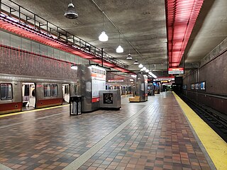
Alewife station is a Massachusetts Bay Transportation Authority (MBTA) intermodal transit station in the North Cambridge neighborhood of Cambridge, Massachusetts. It is the northwest terminal of the rapid transit Red Line and a hub for several MBTA bus routes. The station is at the confluence of the Minuteman Bikeway, Alewife Linear Park, Fitchburg Cutoff Path, and Alewife Greenway off Alewife Brook Parkway adjacent to Massachusetts Route 2, with a five-story parking garage for park and ride use. The station has three bike cages. Alewife station is named after nearby Alewife Brook Parkway and Alewife Brook, themselves named after the alewife fish.
Porter is a Massachusetts Bay Transportation Authority (MBTA) transit station in Cambridge, Massachusetts. It serves the Red Line rapid transit line, the MBTA Commuter Rail Fitchburg Line, and several MBTA bus lines. Located at Porter Square at the intersection of Massachusetts and Somerville Avenues, the station provides rapid transit access to northern Cambridge and the western portions of Somerville. Porter is 14 minutes from Park Street on the Red Line, and about 10 minutes from North Station on commuter rail trains. Several local MBTA bus routes also stop at the station.
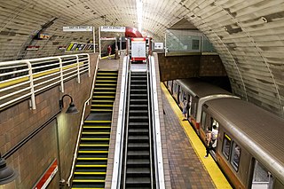
Davis station is an underground Massachusetts Bay Transportation Authority (MBTA) Red Line rapid transit station located at Davis Square in Somerville, Massachusetts. The accessible station has a single island platform for the Red Line, as well as a dedicated busway on the surface. It opened in 1984 as part of the Red Line Northwest Extension project.
The Minuteman Bikeway is a 10-mile (16-kilometre) paved multi-use rail trail located in the Greater Boston area of Massachusetts. It runs from Bedford to Alewife station, at the northern end of the Red Line in Cambridge, passing through the towns of Lexington and Arlington along the way. Also along the route are several notable regional sites, including Alewife Brook Reservation, the Cyrus Dallin Art Museum, Spy Pond, "Arlington’s Great Meadows", the Battle Green in Lexington, and Hanscom Air Force Base.
The Somerville Community Path is a paved rail trail in Somerville, Massachusetts, running 1.3 miles (2.1 km) from Massachusetts Avenue to Lowell Street via Davis Square. Opened in segments between 1985 and 2015, it follows part of the former Fitchburg Cutoff rail line. A 1.9-mile (3.1 km) extension to East Cambridge will open in 2022 as part of the Green Line Extension project.
The Boston and Lowell Railroad was a railroad that operated in Massachusetts in the United States. It was one of the first railroads in North America and the first major one in the state. The line later operated as part of the Boston and Maine Railroad's Southern Division.
The Middlesex and Boston Street Railway (M&B) was a streetcar and later bus company in the area west of Boston. Streetcars last ran in 1930, and in 1972 the company's operations were merged into the Massachusetts Bay Transportation Authority (MBTA).
The Grand Junction Railroad is an 8.55-mile (13.76 km) long railroad in the Boston, Massachusetts, area, connecting the railroads heading west and north from Boston. Most of it is still in use, carrying scrap either inbound or outbound to the Schnitzer scrap yard on the Everett waterfront or freight to the Chelsea Produce Market, and non-revenue transfers of Amtrak and MBTA passenger equipment between the lines terminating at North Station and South Station. The line is also notable for its railroad bridge over the Charles River that passes under the Boston University Bridge between Boston and Cambridge, Massachusetts.
The Fitchburg Railroad is a former railroad company, which built a railroad line across northern Massachusetts, United States, leading to and through the Hoosac Tunnel. The Fitchburg was leased to the Boston and Maine Railroad in 1900. The main line from Boston to Fitchburg is now operated as the MBTA Fitchburg Line; Pan Am Railways runs freight service on some other portions.
Alewife Brook Reservation is a Massachusetts state park and urban wild located in Cambridge, Arlington, and Somerville. The park is managed by the state Department of Conservation and Recreation and was established in 1900. It is named for Alewife Brook, which was also historically known as Menotomy River, a tributary of the Mystic River.
The Fitchburg Cutoff was a rail line running 2.8 miles (4.5 km) from Brighton Street in Belmont, Massachusetts, to Somerville Junction in Somerville, Massachusetts. It was constructed in two segments in 1870 and 1881 to connect the Lexington Branch and Central Massachusetts Railroad to the Boston and Lowell Railroad. Passenger service lasted until 1927. Freight service ended in 1979–80 to allow construction of the Red Line Northwest Extension; the line was abandoned in three sections in 1979, 1983, and 2007.
West Concord station is an MBTA Commuter Rail station located in West Concord, Massachusetts. It is served by the Fitchburg Line. The station has two side platforms serving the line's two tracks, with mini-high platforms for accessibility. The adjacent station building, now a restaurant, is not used for railroad purposes.
Ayer station is an MBTA Commuter Rail station located off Main Street in the Ayer Main Street Historic District of Ayer, Massachusetts. It serves the Fitchburg Line. There are three tracks through the station, two of which are served by a pair of low-level side platforms, which are not accessible. There is a shelter on the inbound platform.
Bedford Depot is a historic railroad depot in Bedford, Massachusetts, United States. Bedford was the junction of the Reformatory Branch and the Lexington Branch of the Boston and Maine Railroad; it saw passenger service until 1977 as the stub of the Lexington Branch. The original 1874 depot and 1877 freight house are listed on the National Register of Historic Places; along with a restored Budd Rail Diesel Car, they form the centerpieces of the Bedford Depot Park.
The Watertown Branch Railroad was a branch loop of the Fitchburg Railroad that was meant to serve the town of Watertown and the City of Waltham, Middlesex County, Massachusetts, as an independent short line railroad; it also serviced the Watertown Arsenal. The line has been formally abandoned and portions have been converted into a rail trail, the Watertown-Cambridge Greenway. A section from School Street to Arlington Street in Watertown was completed first. A small portion in Waltham has been converted into a park called Chemistry Station Park after the railroad station once located there. Construction of an extension to Fresh Pond Reservation in Cambridge began in the summer of 2018 and was completed in June 2022.
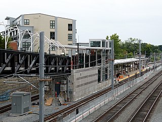
Magoun Square station is an under-construction light rail station on the Massachusetts Bay Transportation Authority (MBTA) Green Line located at Lowell Street south of Magoun Square in Somerville, Massachusetts. The accessible station has a single island platform serving the two tracks of the Medford Branch. It is planned to open in November 2022 as part of the Green Line Extension (GLX), which is adding two northern branches to the Green Line, and will be served by the E branch.
Lexington Depot, or Lexington station, is a former train station in Lexington, Massachusetts on the Lexington Branch.
The Massachusetts Bay Transportation Authority operates subway, bus, commuter rail, and ferry service in the Greater Boston region. Boston has some of the highest rates of non-motorized commuting in the United States, including high bicycle usage. The MBTA offers certain provisions for riders wishing to make part of their trips by bicycle. The agency allows bicycles to be carried on all fixed-route services except the Green Line and the Ashmont-Mattapan High Speed Line light rail lines, although they are restricted on the commuter rail and heavy rail subway services at peak hours. Bicycle storage areas are offered at many stations, with "Pedal and Park" locking bicycle cages at certain high-usage stations.
Arlington station was a regional rail station in Arlington, Massachusetts. Located in downtown Arlington, it served the Lexington Branch. It was closed in January 1977 when service on the Lexington Branch was suspended.
Lake Street station was a commuter rail station on the Lexington Branch, located in the East Arlington section of Arlington, Massachusetts. The line opened as the Lexington and West Cambridge Railroad in 1846, with a station at Pond Street among the earliest stops. It was renamed Lake Street in 1867. The Boston and Lowell Railroad (B&L) acquired the line in 1870 and built a new station building in 1885. Service continued under the Boston and Maine Railroad (B&M) – successor to the B&L – though it declined during the 20th century. Lake Street station and three others on the line were closed in May 1958. The Massachusetts Bay Transportation Authority (MBTA) began subsidizing service in 1965, and Lake Street station reopened in March 1968. All passenger service on the Lexington Branch ended on January 10, 1977; it was converted into the Minuteman Bikeway in the early 1990s.
This page is based on this Wikipedia article Text is available under the CC BY-SA 4.0 license; additional terms may apply. Images, videos and audio are available under their respective licenses.