Middlesex and Boston Street Railway

Last updated

The Middlesex and Boston Street Railway (M&B) was a streetcar and later bus company in the area west of Boston. Streetcars last ran in 1930, and in 1972 the company's operations were merged into the Massachusetts Bay Transportation Authority (MBTA).

Contents

History

The company was first chartered as the Natick Electric Street Railway on August 10, 1891. The name was changed to the South Middlesex Street Railway in 1893. That company went bankrupt and a receiver was appointed May 6, 1903; the property was sold on August 15, 1907, to the newly formed Middlesex and Boston Street Railway. By 1910, Boston Suburban Electric Companies, a holding company, had bought the M&B.

In September 1964 the MBTA began subsidizing the M&B, and route numbers were given to its buses. (According to "A Chronicle of the Boston Transit System" (April 16, 1981) the subsidy agreement was signed on December 23, 1964.) The M&B was taken over by the MBTA on July 5, 1972, after a financial dispute over subsidies stopped service on June 30. The routes taken over were renumbered by adding a 5 to the beginning and were renumbered in September 1982 and some in 1996.

There is one streetcar and one bus preserved from this railway, trolley # 41, a former Lexington car, and bus # 192, a 1948 ACF Brill bus. They are both located at the Seashore Trolley Museum in Kennebunkport, Maine.

Auburndale–Lake Street via Commonwealth Avenue

Wide median of Commonwealth Avenue in Auburndale, once used by M&B trolleys, near Norumbega Park Wide median of Commonwealth Avenue, Auburndale, MA.JPG
Wide median of Commonwealth Avenue in Auburndale, once used by M&B trolleys, near Norumbega Park

The Commonwealth Avenue Street Railway was opened on March 26, 1896. [1] The line ran down the median the entire length of Commonwealth Avenue in Newton from Auburndale to Boston College, where it connected with the Commonwealth Avenue line of the Boston Elevated Railway. The latter line did not opened until August 15, 1896; omnibuses were temporarily run between Reservoir and Lake Street. [1] [2] :58 The company opened Norumbega Park on June 17, 1897, as an amusement park to increase traffic on the line. [2] :38 Through service between Norumbega Park and Park Street was run from January 17, 1903, to November 1, 1914. [2] :39

In December 1895, the company was denied rights to construct a branch over Center Street from its not-yet-complete Commonwealth Avenue line to Newton Center because of its refusal to pay for street widening. [3] [4] However, the branch was later approved and constructed, allowing the line to complete with the Newton and Boston Street Railway's Newton Center branch. [5] [6] An extension from Newton Center to Newton Highlands via Cypress, Paul, and Center opened on June 15, 1899. [7]

The line was consolidated into the Newton Street Railway on January 1, 1904; the Newton Street Railway was merged with the M&B on July 1, 1909. [2] :39 The Commonwealth Avenue line was the last of the M&B streetcar routes to be converted to buses; this occurred in April 1930. [8] The park closed in 1964.

Route 35 Auburndale–Lake Street was not initially operated by the MBTA upon the July 1972 takeover. The MBTA resumed service in January 1973 as rush hour-only route 535 Auburndale–Boston College via Commonwealth Avenue. Largely used by domestic workers commuting to wealthy neighborhoods in Newton, it was dropped in June 1976. [9]

Bedford–Lowell

From Bedford, cars left every 15 minutes in the summer, and every half-hour in the winter, for

Fare limits were at the town lines of Bedford with Lexington, Concord, and Billerica.

The line from Lexington ran down Bedford Street and the Great Road, diverting along Loomis Street and South Road to connect with the Boston and Maine Railroad station. A passing track was located on the north side of Bedford Common.

As at Norumbega, an amusement park was built in Lexington near the Bedford town line, to attract riders from the city.

The Bedford–Arlington Heights bus, today's 62 was M&B route 29 and MBTA route 529.

The car-barn and electricity generator were located in North Lexington north of Bedford Street and just west of the corner of what is now Worthen Road. The complex was composed of at least a long wooden building (the carbarn) and a squat brick structure with a short smokestack (the generating plant); that complex was a lumberyard for many years and was redeveloped in the late 1980s.

Waltham–Newton

The Waltham and Newton Street Railway was chartered on July 13, 1866, and began service on August 31, 1868. Its tracks ran from the split between Pleasant Street and Main Street, west of Waltham center, via Main Street, Moody Street, Crescent Street and Moody Street to the Newton line, then via Lexington Street, River Street, Elm Street and Washington Street to end at Highland Street in West Newton.

In 1889 the Newton Street Railway bought the line, and the Newton Street Railway was merged with the M&B July 1, 1909. It later (by 1964) became much of the 20 Newton Corner–Riverside via Roberts and Central Square Waltham bus line, with the 27 Newton Corner–Riverside via Auburndale and Central Square Waltham using much of Crescent Street (the 20 went straight through on Moody Street). This is now the 553 Roberts–Downtown Boston via Newton Corner and Central Square Waltham, with Crescent Street served by the 558 Riverside–Downtown Boston via Auburndale, Central Square Waltham and Newton Corner.

Other routes

Related Research Articles

<span class="mw-page-title-main">Auburndale, Massachusetts</span> Village in Massachusetts, United States

Auburndale is one of the thirteen villages within the city of Newton in Middlesex County, Massachusetts, United States. It lies at the western end of Newton near the intersection of interstate highways 90 and 95. It is bisected by the Massachusetts Turnpike. Auburndale is surrounded by three other Newton villages as well as the city of Waltham and the Charles River. Auburndale is the home of Williams and Burr elementary schools, as well as Lasell College. Auburndale Square is the location of the Plummer Memorial Library, which is run by the Auburndale Community Library and no longer affiliated with the Newton Free Library, the Turtle Lane Playhouse, and many small businesses.

<span class="mw-page-title-main">Cleveland Circle</span> Neighborhood and streetcar terminal of Boston, USA

Cleveland Circle, an area of Boston, Massachusetts, is located in Boston's Brighton neighborhood, and more specifically the Aberdeen section of Brighton, in very close proximity to Brookline and Chestnut Hill, Massachusetts, at the intersection of Beacon Street and Chestnut Hill Avenue.

<span class="mw-page-title-main">MBTA bus</span> Greater Boston bus network

The Massachusetts Bay Transportation Authority (MBTA) operates 170 bus routes in the Greater Boston area. The MBTA has a policy objective to provide transit service within walking distance for all residents living in areas with population densities greater than 5,000 inhabitants per square mile (1,900/km2) within the MBTA's service district. Much of this service is provided by bus. In 2021, the system had a ridership of 64,728,000, or about 271,200 per weekday as of the third quarter of 2022.

<span class="mw-page-title-main">Boston College station</span> Light rail station in Boston, Massachusetts, US

Boston College station is a light rail station on the MBTA Green Line B branch. It is located at St. Ignatius Square on the Boston College campus near the intersection of Commonwealth Avenue and Lake Street, on the border between the Brighton neighborhood of Boston and the Chestnut Hill neighborhood of Newton, Massachusetts. Originally opened in 1896, it has been the terminus of the Commonwealth Avenue line since 1900. The current station is planned to be replaced by a new station located in the median of Commonwealth Avenue just east of Lake Street.

<span class="mw-page-title-main">Riverside station (MBTA)</span> Light rail station in Newton, Massachusetts

Riverside is the western terminus of the MBTA Green Line D branch light rail line. It is located at 333 Grove Street, off Exit 38 on Interstate 95, in Auburndale, a village of Newton, Massachusetts. Riverside includes a parking lot with spaces for 925 automobiles and bicycle parking. West of the station is Riverside Yard, the main maintenance facility and largest storage yard for the Green Line. The station is fully accessible.

<span class="mw-page-title-main">Hynes Convention Center station</span> Boston, Massachusetts light rail station

Hynes Convention Center station is an underground light rail station on the Massachusetts Bay Transportation Authority (MBTA) Green Line. It is located at the intersection of Newbury Street and Massachusetts Avenue near the western end of the Back Bay neighborhood of Boston, Massachusetts. The station is named for the Hynes Convention Center, which is located about 700 feet (210 m) to the east along Boylston Street. It has two side platforms serving the two tracks of the Boylston Street subway, which are used by the Green Line B branch, C branch, and D branch. The main entrance to the station from Massachusetts Avenue leads to a fare lobby under the 360 Newbury Street building.

<span class="mw-page-title-main">Boston Elevated Railway</span> Defunct public transit company serving the Boston metro area, MA, USA (1894-1947)

The Boston Elevated Railway (BERy) was a streetcar and rapid transit railroad operated on, above, and below, the streets of Boston, Massachusetts and surrounding communities. Founded in 1894, it eventually acquired the West End Street Railway via lease and merger to become the city's primary mass transit provider. Its modern successor is the state-run Massachusetts Bay Transportation Authority (MBTA), which continues to operate in part on infrastructure developed by BERy and its predecessors.

<span class="mw-page-title-main">Newton and Boston Street Railway</span>

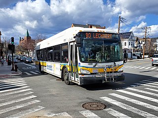
The Newton and Boston Street Railway was a streetcar company in the Boston, Massachusetts area, eventually bought by the Middlesex and Boston Street Railway. Its line is now the 59 Needham Junction – Watertown Square via Newtonville bus.

<span class="mw-page-title-main">Boston and Worcester Street Railway</span>

Boston and Worcester Electric Companies (B&W) was a holding company for several streetcar companies between Boston and Worcester, Massachusetts. The main line, built by the Boston and Worcester Street Railway, was an interurban streetcar line partly on the old Boston and Worcester Turnpike and partly on private right-of-way. Long after the line was converted to buses, Boston and Worcester Lines took over operations, and sold the franchises to various other bus companies.

<span class="mw-page-title-main">Green Line E branch</span> Light rail line

The E branch is a light rail line in Boston, Cambridge, Medford, and Somerville, Massachusetts, operating as part of the Massachusetts Bay Transportation Authority (MBTA) Green Line. The line runs in mixed traffic on South Huntington Avenue and Huntington Avenue between Heath Street and Brigham Circle, in the median of Huntington Avenue to Northeastern University, then into the Huntington Avenue subway. The line merges into the Boylston Street subway just west of Copley, running to North Station via the Tremont Street subway. It then follows the Lechmere Viaduct to Lechmere, then the Medford Branch to Medford/​Tufts. As of February 2022, service operates on 7 to 7.5-minute headways on weekdays and 9-minute headways on weekends, using 12 to 15 trains.

<span class="mw-page-title-main">Green Line B branch</span> Light rail line in Boston, Massachusetts

The B branch, also called the Commonwealth Avenue branch or Boston College branch, is a branch of the MBTA Green Line light rail system which operates on Commonwealth Avenue west of downtown Boston, Massachusetts. One of four branches of the Green Line, the B branch runs from Boston College station down the median of Commonwealth Avenue to Blandford Street. There, it enters Blandford Street portal into Kenmore station, where it merges with the C and D branches. The combined services run into the Boylston Street subway and Tremont Street subway to downtown Boston. B branch service has terminated at Government Center since October 2021. Unlike the other branches, the B branch runs solely through the city limits of Boston. The Green Line Rivalry between Boston College and Boston University is named in reference to the B branch, which runs to both universities.

<span class="mw-page-title-main">Green Line A branch</span> Former streetcar line in Boston, Newton, and Watertown, Massachusetts

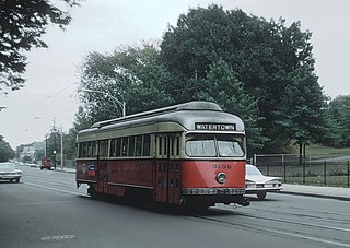
The A branch or Watertown Line was a streetcar line in the Boston, Massachusetts, area, operating as a branch of the Massachusetts Bay Transportation Authority Green Line. The line ran from Watertown through Newton Corner, Brighton, and Allston to Kenmore Square, then used the Boylston Street subway and Tremont Street subway to reach Park Street station.

<span class="mw-page-title-main">Boston-area streetcar lines</span>

As with many large cities, a large number of Boston-area streetcar lines once existed, and many continued operating into the 1950s. However, only a few now remain, namely the four branches of the Green Line and the Ashmont–Mattapan High-Speed Line, with only one running regular service on an undivided street.

The Massachusetts Bay Transportation Authority (MBTA) maintains a large public transit system in the Boston, Massachusetts area, and uses various methods to name and number their services for the convenience of users.
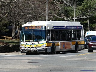
<span class="mw-page-title-main">86 (MBTA bus)</span> Bus route in Greater Boston

Route 86 is a local bus route in Boston, Cambridge, and Somerville, Massachusetts, operated by the Massachusetts Bay Transportation Authority (MBTA) as part of MBTA bus service. It operates on a circumferential route between Sullivan Square station and Reservoir station via Union Square, Somerville, Harvard Square, and Brighton Center. In 2018, it had the 18th-highest weekday ridership on the system, though it ranked 37th by number of weekday trips. A 2018–19 MBTA review of its bus system found that route 86 had infrequent and unreliable service, including irregular scheduled headways, despite its high ridership and significance as a crosstown connecting route.

<span class="mw-page-title-main">Commonwealth Avenue (Boston)</span>

Commonwealth Avenue is a major street in the cities of Boston and Newton, Massachusetts. It begins at the western edge of the Boston Public Garden, and continues west through the neighborhoods of the Back Bay, Kenmore Square, Boston University, Allston, Brighton and Chestnut Hill. It continues as part of Route 30 through Newton until it crosses the Charles River at the border of the town of Weston.

<span class="mw-page-title-main">Babcock Street station</span> Light rail station in Boston, Massachusetts, US

Babcock Street station is a light rail stop on the Massachusetts Bay Transportation Authority (MBTA) Green Line B branch, located in the median of Commonwealth Avenue in the west part of the Boston University campus. The accessible station has two side platforms serving the line's two tracks, with access at Babcock Street and Pleasant Street.

<span class="mw-page-title-main">Newton Corner station</span> Boston MBTA former subway station

Newton Corner was a streetcar and passenger rail station in the Newton Corner neighborhood of Newton, Massachusetts, located near where Washington Street crosses the Massachusetts Turnpike. The Newton Corner station, known simply as Newton for much of its lifetime, served commuters on the Worcester Line from 1834 to 1959. The trolley stop, located on the surface streets, served a number of routes beginning in 1898, including the Green Line A branch until 1969.

<span class="mw-page-title-main">Ipswich Street line</span> Former streetcar line in Boston and Brookline, Massachusetts

The Ipswich Street line was a streetcar line in Boston and Brookline, Massachusetts. The line ran on Boylston Street and Ipswich Street in the Fenway–Kenmore neighborhood, and on Brookline Avenue through what is now the Longwood Medical Area to Brookline Village.

References

  1. 1 2 "Commonwealth Av. Street Railway Company". Boston Globe. March 27, 1896. p. 5 via Newspapers.com. Open Access logo PLoS transparent.svg
  2. 1 2 3 4 Clarke, Bradley H.; Cummings, O.R. (1997). Tremont Street Subway: A Century of Public Service. Boston Street Railway Association. ISBN   0938315048.
  3. "Mayor's Veto Sustained". Boston Globe. December 31, 1895. p. 7 via Newspapers.com. Open Access logo PLoS transparent.svg
  4. "In Line of Rapid Transit". Boston Globe. December 17, 1895. p. 7 via Newspapers.com. Open Access logo PLoS transparent.svg
  5. "Newton". Boston Globe. April 1, 1896. p. 5 via Newspapers.com. Open Access logo PLoS transparent.svg
  6. "Newton City Fathers". Boston Globe. March 17, 1896. p. 3 via Newspapers.com. Open Access logo PLoS transparent.svg
  7. "Special Car Over New Line". Boston Globe. June 16, 1899. p. 8 via Newspapers.com. Open Access logo PLoS transparent.svg
  8. Carlson, Stephen P.; Harding, Thomas W. (1990). From Boston to the Berkshires: a pictorial review of electric transportation in Massachusetts. Boston Street Railway Association. p. 103. ISBN   093831503X.
  9. Belcher, Jonathan. "Changes to Transit Service in the MBTA district" (PDF). Boston Street Railway Association.