
The Blue Line is a rapid transit line in the Greater Boston metropolitan area, one of four rapid transit lines operated by the Massachusetts Bay Transportation Authority (MBTA). It runs from Bowdoin station in downtown Boston under Boston Harbor to East Boston and Revere on the inner North Shore, where it terminates at Wonderland. The stop at Airport Station, by way of a free shuttle bus, is one of two rapid transit connections to Logan International Airport. In 1967, during a systemwide rebranding, the line was assigned the blue color because it passes under the Boston Harbor. With an end-to-end travel time of less than twenty minutes, the Blue Line is the shortest of Boston's heavy-rail lines and the only line to have both third rail and overhead catenary sections.

Harvard station is a rapid transit and bus transfer station in Cambridge, Massachusetts. Located at Harvard Square, it serves the MBTA's Red Line subway system as well as MBTA buses. Harvard averaged 18,528 entries each weekday in FY2019, making it the third-busiest MBTA station after Downtown Crossing and South Station. Five of the fifteen key MBTA bus routes stop at the station.

The Maurice J. Tobin Memorial Bridge is a cantilever truss bridge that spans more than two miles (3.2 km) from Boston to Chelsea over the Mystic River in Massachusetts. The bridge is the largest in New England. It is operated by the Massachusetts Department of Transportation and carries U.S. Route 1. It was built between 1948 and 1950 and opened to traffic on February 2, 1950, replacing the former Chelsea Bridge. The 36-foot (11 m)-wide roadway has three lanes of traffic on each of the two levels with northbound traffic on the lower level and southbound traffic on the upper level.

The Boston, Revere Beach and Lynn Railroad was a 3 ft narrow-gauge passenger-carrying shortline railroad between East Boston and Lynn, Massachusetts, from 1875 to 1940. Part of the railroad's right of way now forms the outer section of the Massachusetts Bay Transportation Authority's Blue Line rapid transit service.
The Massachusetts Bay Transportation Authority (MBTA) operates 152 bus routes in the Greater Boston area. The MBTA has a policy objective to provide transit service within walking distance for all residents living in areas with population densities greater than 5,000 inhabitants per square mile (1,900/km2) within the MBTA's service district. Much of this service is provided by bus. In 2022, the system had a ridership of 83,623,600, or about 283,900 per weekday as of the second quarter of 2023.

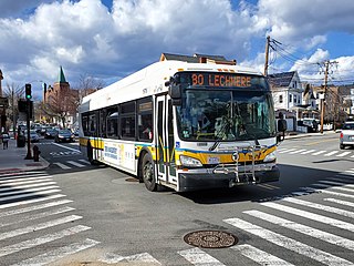
Lechmere station is a Massachusetts Bay Transportation Authority (MBTA) Green Line light rail station in Lechmere Square in East Cambridge, Massachusetts. It is located on the east side of Monsignor O'Brien Highway near First Street, adjacent to the NorthPoint development. The accessible elevated station has a single island platform, with headhouses at both ends. It opened on March 21, 2022, as part of the Green Line Extension (GLX). Lechmere station is served by Green Line D branch and E branch service.

Hynes Convention Center station is an underground light rail station on the Massachusetts Bay Transportation Authority (MBTA) Green Line. It is located at the intersection of Newbury Street and Massachusetts Avenue near the western end of the Back Bay neighborhood of Boston, Massachusetts. The station is named for the Hynes Convention Center, which is located about 700 feet (210 m) to the east along Boylston Street. It has two side platforms serving the two tracks of the Boylston Street subway, which are used by the Green Line B branch, C branch, and D branch. The main entrance to the station from Massachusetts Avenue leads to a fare lobby under the 360 Newbury Street building.

The E branch is a light rail line in Boston, Cambridge, Medford, and Somerville, Massachusetts, operating as part of the Massachusetts Bay Transportation Authority (MBTA) Green Line. The line runs in mixed traffic on South Huntington Avenue and Huntington Avenue between Heath Street and Brigham Circle, in the median of Huntington Avenue to Northeastern University, then into the Huntington Avenue subway. The line merges into the Boylston Street subway just west of Copley, running to North Station via the Tremont Street subway. It then follows the Lechmere Viaduct to Lechmere, then the Medford Branch to Medford/Tufts. As of February 2023, service operates on eight-minute headways at weekday peak hours and eight to nine-minute headways at other times, using 13 to 17 trains.

The B branch, also called the Commonwealth Avenue branch or Boston College branch, is a branch of the MBTA Green Line light rail system which operates on Commonwealth Avenue west of downtown Boston, Massachusetts. One of four branches of the Green Line, the B branch runs from Boston College station down the median of Commonwealth Avenue to Blandford Street. There, it enters Blandford Street portal into Kenmore station, where it merges with the C and D branches. The combined services run into the Boylston Street subway and Tremont Street subway to downtown Boston. B branch service has terminated at Government Center since October 2021. Unlike the other branches, the B branch runs solely through the city limits of Boston. The Green Line Rivalry between Boston College and Boston University is named in reference to the B branch, which runs to both universities.
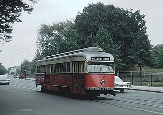
The A branch or Watertown Line was a streetcar line in the Boston, Massachusetts, area, operating as a branch of the Massachusetts Bay Transportation Authority Green Line. The line ran from Watertown through Newton Corner, Brighton, and Allston to Kenmore Square, then used the Boylston Street subway and Tremont Street subway to reach Park Street station.

As with many large cities, a large number of Boston-area streetcar lines once existed, and many continued operating into the 1950s. However, only a few now remain, namely the four branches of the Green Line and the Ashmont–Mattapan High-Speed Line, with only one running regular service on an undivided street.

Sullivan Square station is a rapid transit station on the MBTA subway Orange Line, located adjacent to Sullivan Square in the Charlestown neighborhood of Boston, Massachusetts. It is a major transfer point for MBTA bus service, with 13 routes using a two-level busway. The station has two island platforms serving the two active Orange Line tracks plus an unused third track. The Haverhill Line and Newburyport/Rockport Line pass through the station on separate tracks but do not stop.
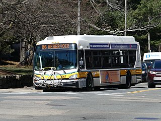
Route 86 is a local bus route in Boston, Cambridge, and Somerville, Massachusetts, operated by the Massachusetts Bay Transportation Authority (MBTA) as part of MBTA bus service. It operates on a circumferential route between Sullivan Square station and Reservoir station via Union Square, Somerville, Harvard Square, and Brighton Center. In 2018, it had the 18th-highest weekday ridership on the system, though it ranked 37th by number of weekday trips. A 2018–19 MBTA review of its bus system found that route 86 had infrequent and unreliable service, including irregular scheduled headways, despite its high ridership and significance as a crosstown connecting route.
Wonderland station is a transit station in Revere, Massachusetts located adjacent to Revere Beach. It is the northern terminus of the MBTA Blue Line rapid transit line, as well as a major bus transfer station for Revere and the North Shore area, serving MBTA bus routes 110, 116, 117, 411, 424, 426W, 439, 441, 442, 450W, and 455. The station is fully accessible.

Beachmont station is an elevated rapid transit station in Revere, Massachusetts. It serves the MBTA Blue Line, and is located above Winthrop Avenue in the Beachmont neighborhood. Beachmont station is fully accessible, with elevators from the lobby to the platforms.

Suffolk Downs station is a rapid transit station on the Massachusetts Bay Transportation Authority (MBTA) Blue Line, located on the east side of Orient Heights in East Boston, Massachusetts, United States. It is named for the now-defunct Suffolk Downs racetrack, located just to the north. Suffolk Downs station has two side platforms, with a footbridge structure of brick, concrete, and steel connecting them. The station is accessible. With just 521 daily boardings in FY 2019, Suffolk Downs is the least-used fare-controlled station on the MBTA subway system.

Orient Heights station is a rapid transit station in Boston, Massachusetts. The station serves the MBTA Blue Line. It is located off Bennington Street in East Boston's Orient Heights neighborhood. Formerly a Boston, Revere Beach and Lynn Railroad station under various names from 1875 to 1940, it reopened in 1952. The 1952-built station was closed in March 2013 for a complete rebuilding to provide full accessibility and reopened on November 26, 2013.

Lynn station is an intermodal transit station in downtown Lynn, Massachusetts. It is a station on the MBTA Commuter Rail Newburyport/Rockport Line and a hub for the MBTA bus system. The rail station and parking garage temporarily closed on October 1, 2022, pending a reconstruction project, while the busway remains open. Interim platforms are expected to open in December 2023.

The Ipswich Street line was a streetcar line in Boston and Brookline, Massachusetts. The line ran on Boylston Street and Ipswich Street in the Fenway–Kenmore neighborhood, and on Brookline Avenue through what is now the Longwood Medical Area to Brookline Village.

