The Boston and Maine Railroad was a U.S. Class I railroad in northern New England. Originally chartered in 1835, it became part of what was the Pan Am Railways network in 1983.
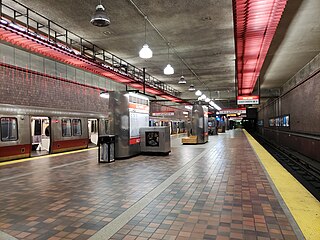
Alewife station is a Massachusetts Bay Transportation Authority (MBTA) intermodal transit station in the North Cambridge neighborhood of Cambridge, Massachusetts. It is the northwest terminal of the rapid transit Red Line and a hub for several MBTA bus routes. The station is at the confluence of the Minuteman Bikeway, Alewife Linear Park, Fitchburg Cutoff Path, and Alewife Greenway off Alewife Brook Parkway adjacent to Massachusetts Route 2, with a five-story parking garage for park and ride use. The station has three bike cages. Alewife station is named after nearby Alewife Brook Parkway and Alewife Brook, themselves named after the alewife fish.
Porter station is a Massachusetts Bay Transportation Authority (MBTA) transit station in Cambridge, Massachusetts. It serves the Red Line rapid transit line, the MBTA Commuter Rail Fitchburg Line, and several MBTA bus lines. Located at Porter Square at the intersection of Massachusetts and Somerville Avenues, the station provides rapid transit access to northern Cambridge and the western portions of Somerville. Porter is 14 minutes from Park Street on the Red Line, and about 10 minutes from North Station on commuter rail trains. Several local MBTA bus routes also stop at the station.

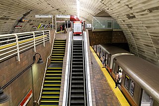
Davis station is an underground Massachusetts Bay Transportation Authority (MBTA) Red Line rapid transit station located at Davis Square in Somerville, Massachusetts. The accessible station has a single island platform for the Red Line, as well as a dedicated busway on the surface. It opened in 1984 as part of the Red Line Northwest Extension project.

The Boston and Albany Railroad was a railroad connecting Boston, Massachusetts to Albany, New York, later becoming part of the New York Central Railroad system, Conrail, and CSX Transportation. The line is currently used by CSX for freight. Passenger service is provided on the line by Amtrak, as part of their Lake Shore Limited service, and by the MBTA Commuter Rail system, which owns the section east of Worcester and operates it as its Framingham/Worcester Line.

The Old Colony Railroad (OC) was a major railroad system, mainly covering southeastern Massachusetts and parts of Rhode Island, which operated from 1845 to 1893. Old Colony trains ran from Boston to points such as Plymouth, Fall River, New Bedford, Newport, Providence, Fitchburg, Lowell and Cape Cod. For many years the Old Colony Railroad Company also operated steamboat and ferry lines, including those of the Fall River Line with express train service from Boston to its wharf in Fall River where passengers boarded luxury liners to New York City. The company also briefly operated a railroad line on Martha's Vineyard, as well as the freight-only Union Freight Railroad in Boston. The OC was named after the "Old Colony", the nickname for the Plymouth Colony.

The Cambridge Railroad was the first street railway in the Boston, Massachusetts area, linking Harvard Square in Cambridge to Cambridge Street and Grove Street in Boston's West End, via Massachusetts Avenue, Main Street and the West Boston Bridge.
The Grand Junction Railroad is an 8.55-mile (13.76 km) long railroad in the Boston, Massachusetts, area, connecting the railroads heading west and north from Boston. The line is notable for its railroad bridge over the Charles River that passes under the Boston University Bridge between Boston and Cambridge, Massachusetts.

The Fitchburg Railroad is a former railroad company, which built a railroad line across northern Massachusetts, United States, leading to and through the Hoosac Tunnel. The Fitchburg was leased to the Boston and Maine Railroad in 1900. The main line from Boston to Fitchburg is now operated as the MBTA Fitchburg Line; Pan Am Railways runs freight service on some other portions.
The Central Massachusetts Railroad was a railroad in Massachusetts. The eastern terminus of the line was at North Cambridge Junction where it split off from the Middlesex Central Branch of the Boston and Lowell Railroad in North Cambridge and through which it had access to North Station in Boston. From there, the route ran 98.77 miles west through the modern-day towns of Belmont, Waltham, Weston, Wayland, Sudbury, Hudson, Bolton, Berlin, Clinton, West Boylston, Holden, Rutland, Oakham, Barre, New Braintree, Hardwick, Ware, Palmer, Belchertown, Amherst, and Hadley to its western terminal junction at N. O. Tower in Northampton with the Connecticut River Railroad.

The Fitchburg Line is a branch of the MBTA Commuter Rail system which runs from Boston's North Station to Wachusett station in Fitchburg, Massachusetts. The line is along the tracks of the former Fitchburg Railroad, which was built across northern Massachusetts, United States, in the 1840s. Winter weekend service includes a specially equipped seasonal "ski train" to Wachusett Mountain.

The Fitchburg Cutoff was a rail line running 2.8 miles (4.5 km) from Brighton Street in Belmont, Massachusetts, to Somerville Junction in Somerville, Massachusetts. It was constructed in two segments in 1870 and 1881 to connect the Lexington Branch and Central Massachusetts Railroad to the Boston and Lowell Railroad. Passenger service lasted until 1927. Freight service ended in 1979–80 to allow construction of the Red Line Northwest Extension; the line was abandoned in three sections in 1979, 1983, and 2007.
The Lexington and West Cambridge Railroad was a railroad company chartered in 1845 and opened in 1846 that operated in eastern Massachusetts. It and its successors provided passenger service until 1977 and freight service until 1980 or early 1981.
The Fitchburg Subdivision is a railroad line owned by CSX Transportation in the U.S. state of Massachusetts. The line runs from Fitchburg southeast to Framingham Center along a former New York, New Haven and Hartford Railroad line. Its south end is at the Boston Subdivision; the MBTA's Framingham Secondary continues southeast from Framingham.

Ayer station is an MBTA Commuter Rail station located off Main Street in the Ayer Main Street Historic District of Ayer, Massachusetts. It serves the Fitchburg Line. There are three tracks through the station, two of which are served by a pair of low-level side platforms, which are not accessible. There is a shelter on the inbound platform.
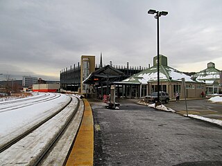
The Fitchburg Intermodal Transportation Center is a regional rail and bus station located in downtown Fitchburg, Massachusetts. It is a stop on the MBTA Commuter Rail Fitchburg Line and a hub for Montachusett Regional Transit Authority local and intercity bus routes.
Cambridge Highlands also known as "Area 12", is a neighborhood of Cambridge, Massachusetts bounded by the railroad tracks on the north and east, the Belmont town line on the west, and Fresh Pond on the south. In 2005 it had a population of 673 residents living in 281 households, and the average household income was $56,500.

The Watertown Branch Railroad was a branch loop of the Fitchburg Railroad that was meant to serve the town of Watertown and the City of Waltham, Middlesex County, Massachusetts, as an independent short line railroad; it also serviced the Watertown Arsenal. The line has been formally abandoned and portions have been converted into a rail trail, the Watertown-Cambridge Greenway. A section from School Street to Arlington Street in Watertown was completed first. A small portion in Waltham has been converted into a park called Chemistry Station Park after the railroad station once located there. Construction of an extension to Fresh Pond Reservation in Cambridge began in the summer of 2018 and was completed in June 2022.

Lake Street station was a commuter rail station on the Lexington Branch, located in the East Arlington section of Arlington, Massachusetts. The line opened as the Lexington and West Cambridge Railroad in 1846, with a station at Pond Street among the earliest stops. It was renamed Lake Street in 1867. The Boston and Lowell Railroad (B&L) acquired the line in 1870 and built a new station building in 1885. Service continued under the Boston and Maine Railroad (B&M) – successor to the B&L – though it declined during the 20th century. Lake Street station and three others on the line were closed in May 1958. The Massachusetts Bay Transportation Authority (MBTA) began subsidizing service in 1965, and Lake Street station reopened in March 1968. All passenger service on the Lexington Branch ended on January 10, 1977; it was converted into the Minuteman Bikeway in the early 1990s.
