Buckingham Fountain is a Chicago Landmark in the center of Grant Park, between Queen's Landing and Ida B. Wells Drive. Dedicated in 1927 and donated to the city by philanthropist Kate S. Buckingham, it is one of the largest fountains in the world. Built in a rococo wedding cake style and inspired by the Latona Fountain at the Palace of Versailles, its design allegorically represents nearby Lake Michigan. The fountain operates from May to mid-October, with regular water shows and evening colored-light shows. During the winter, the fountain is decorated with festival lights.
Daniel Hudson Burnham was an American architect and urban designer. A proponent of the Beaux-Arts movement, he may have been, "the most successful power broker the American architectural profession has ever produced."

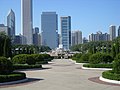
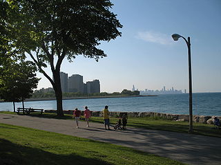
Grant Park is a large urban park in the Loop community area of Chicago, Illinois. Located within the city's central business district, the 319-acre (1.29 km2) park's features include Millennium Park, Buckingham Fountain, the Art Institute of Chicago, and the Museum Campus.

The Loop, one of Chicago's 77 designated community areas, is the central business district of the city and is the main section of Downtown Chicago. Home to Chicago's commercial core, it is the second largest commercial business district in North America and contains the headquarters and regional offices of several global and national businesses, retail establishments, restaurants, hotels, and theaters, as well as many of Chicago's most famous attractions. It is home to Chicago's City Hall, the seat of Cook County, and numerous offices of other levels of government and consulates of foreign nations. The intersection of State Street and Madison Street is the origin point for the address system on Chicago's street grid. Most of Grant Park's 319 acres (1.29 km2) are in the eastern section of the community area. The Loop community area is bounded on the north and west by the Chicago River, on the east by Lake Michigan, and on the south by Roosevelt Road.

Michigan Avenue is a north-south street in Chicago that runs at 100 east on the Chicago grid. Despite being 100 east, if you take into consideration that Wabash and Michigan avenues are evenly placed between State Street and Indiana Avenue, Michigan Avenue is actually closer to 166 or 167 east, to be precise. The northern end of the street is at Lake Shore Drive on the shore of Lake Michigan in the Gold Coast Historic District. The street's southern terminus is at Sibley Boulevard in the southern suburb of Dolton, but like many other Chicago streets, it exists in several disjointed segments.

Wrigley Square is a public square located in the northwest section of Millennium Park in the Historic Michigan Boulevard District of the Loop area of Chicago in Cook County, Illinois, United States. The square is located at the southeast corner of the intersection of East Randolph Street and North Michigan Avenue. It contains the Millennium Monument, a nearly full-sized replica of the semicircle of paired Roman Doric-style columns that originally sat in this area of Grant Park, near Michigan Avenue and Randolph Street, between 1917 and 1953. The square also contains a large lawn and a public fountain.
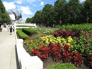
Millennium Park is a public park located in the Loop community area of Chicago, operated by the Chicago Department of Cultural Affairs. The park, opened in 2004 and intended to celebrate the third millennium, is a prominent civic center near the city's Lake Michigan shoreline that covers a 24.5-acre (9.9 ha) section of northwestern Grant Park. Featuring a variety of public art, outdoor spaces and venues, the park is bounded by Michigan Avenue, Randolph Street, Columbus Drive and East Monroe Drive. In 2017, Millennium Park was the top tourist destination in Chicago and in the Midwest, and placed among the top ten in the United States with 25 million annual visitors.

Parks in Chicago include open spaces and facilities, developed and managed by the Chicago Park District. The City of Chicago devotes 8.5% of its total land acreage to parkland, which ranked it 13th among high-density population cities in the United States in 2012. Since the 1830s, the official motto of Chicago has been Urbs in horto, Latin for "City in a garden" for its commitment to parkland. In addition to serving residents, a number of these parks also double as tourist destinations, most notably Lincoln Park, Chicago's largest park, visited by over 20 million people each year, is one of the most visited parks in the United States. Notable architects, artists and landscape architects have contributed to the 570 parks, including Daniel Burnham, Frederick Law Olmsted, Jens Jensen, Dwight Perkins, Frank Gehry, and Lorado Taft.

The Magnificent Mile, sometimes referred to as The Mag Mile, is an upscale section of Chicago's Michigan Avenue, running from the Chicago River to Oak Street in the Near North Side. The district is located within downtown and one block east of Rush Street. The Magnificent Mile serves as the main thoroughfare between Chicago's Loop business district and its Gold Coast. It is generally the western boundary of the Streeterville neighborhood, to its east, and of River North to the west.

Lakeshore East is a master-planned mixed use urban development being built by the Magellan Development Group in the Loop community area of Chicago in Cook County, Illinois, United States. It is located in the northeastern part of the Loop, which, along with Illinois Center, is called the New Eastside. The development is bordered by Wacker Drive to the north, Columbus Drive to the west, Lake Shore Drive to the east, and East Randolph Street to the south. Skidmore, Owings & Merrill created the master plan for the area. The development, which had been scheduled for completion in 2011, was set for completion in 2013 by 2008. Development continued with revised plans for more buildings in 2018 and continuing construction of the Vista Tower in 2019.

The Grand Circus Park Historic District contains the 5-acre (2.0 ha) Grand Circus Park in Downtown Detroit, Michigan that connects the theatre district with its financial district. It is bisected by Woodward Avenue, four blocks north of Campus Martius Park, and is roughly bounded by Clifford, John R. and Adams Streets. The district was listed on the National Register of Historic Places in 1983. The building at 25 West Elizabeth Street was added to the district in 2000, and additional structures located within the district, but built between 1932 and 1960, were approved for inclusion in 2012.

The Carbide & Carbon Building is a 37-story, 503 feet (153 m) landmark Art Deco high rise built in 1929, located on Michigan Avenue in Chicago. It is clad in black granite, green and gold terra cotta, with gold leaf and bronze trim. It was converted to a hotel in 2004.
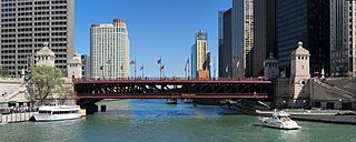
The DuSable Bridge is a bascule bridge that carries Michigan Avenue across the main stem of the Chicago River in downtown Chicago, Illinois, United States. The bridge was proposed in the early 20th century as part of a plan to link Chicago's south side and north side parks with a grand boulevard. Construction of the bridge started in 1918, it opened to traffic in 1920, and decorative work was completed in 1928. The bridge provides passage for vehicles and pedestrians on two levels. An example of a fixed trunnion bascule bridge, it may be raised to allow tall ships and boats to pass underneath. The bridge is included in the Michigan–Wacker Historic District and has been designated as a Chicago Landmark.
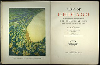
The Burnham Plan is a popular name for the 1909 Plan of Chicago, co-authored by Daniel Burnham and Edward H. Bennett and published in 1909. It recommended an integrated series of projects including new and widened streets, parks, new railroad and harbor facilities, and civic buildings. Though only portions of the plan were realized, the document reshaped Chicago's central area and was an important influence on the new field of city planning.

Edward Herbert Bennett (1874–1954) was an architect and city planner best known for his co-authorship of the 1909 Plan of Chicago.
Burnham Park is a public park located in Chicago, Illinois. Situated along 6 miles (9.7 km) of Lake Michigan shoreline, the park connects Grant Park at 14th Street to Jackson Park at 56th Street. The 598 acres (242 ha) of parkland is owned and managed by Chicago Park District. It was named for urban planner and architect Daniel Burnham in 1927. Burnham was one of the designers of the 1893 World's Columbian Exposition.

The Historic Michigan Boulevard District is a historic district in the Loop community area of Chicago in Cook County, Illinois, United States encompassing Michigan Avenue between 11th or Roosevelt Road, depending on the source, and Randolph Streets and named after the nearby Lake Michigan. It was designated a Chicago Landmark on February 27, 2002. The district includes numerous significant buildings on Michigan Avenue facing Grant Park. In addition, this section of Michigan Avenue includes the point recognized as the end of U.S. Route 66. This district is one of the world's best known one-sided streets rivalling Fifth Avenue in New York City and Edinburgh's Princes Street. It lies immediately south of the Michigan–Wacker Historic District and east of the Loop Retail Historic District.

The Exelon Pavilions are four buildings that generate electricity from solar energy and provide access to underground parking in Millennium Park in the Loop community area of Chicago in Cook County, Illinois, United States. The Northeast Exelon Pavilion and Northwest Exelon Pavilion are located on the northern edge of the park along Randolph Street, and flank the Harris Theater. The Southeast Exelon Pavilion and Southwest Exelon Pavilion are located on the southern edge of the park along Monroe Street, and flank the Lurie Garden. Together the pavilions generate 19,840 kilowatt-hours (71,400 MJ) of electricity annually, worth about $2,350 per year.

Ida B. Wells Drive is a major east–west street in downtown Chicago, Illinois, in the United States. It runs east from the Jane Byrne Interchange, where it meets Interstate 90 (I-90), I-94 and I-290. At Wells Street, Ida B. Wells Drive continues as a surface street past State Street and Michigan Avenue, until ending at Columbus Drive in Grant Park in front of the Buckingham Fountain. In 2018, the editorial board of The New York Times praised the Chicago City Council's renaming of the street to honor the journalist and civil rights activist Ida B. Wells.