
Transport in Jersey is primarily through the motor vehicle. The island, which is the largest of the Channel Islands has 124,737 registered vehicles (2016). The island is committed to combatting climate change, having declared a climate emergency, and policy is focused on reducing dependence on the car. The island has a cycle network and bus service. The primary modes of transport for leaving the island are by air or sea.
The A2 is a major road in south-east England, connecting London with the English Channel port of Dover in Kent. This route has always been of importance as a connection between London and sea trade routes to Continental Europe. It was originally known as the Dover Road. The M2 motorway has replaced part of the A2 as the strategic route.

St Helier is the capital of Jersey, the largest of the Channel Islands in the English Channel. St Helier has a population of 35,822 – over one-third of the total population of Jersey – and is one of the twelve parishes of Jersey. The town of St Helier is the largest settlement and only town of Jersey. The town consists of the built-up areas of St Helier, including First Tower, and parts of the parishes of St Saviour and St Clement, with further suburbs in surrounding parishes. The greater part of St Helier is rural.

The A9 motorway is a motorway in the Netherlands. The motorway starts off by going from the A1 at Diemen to the A2 at junction 'Holendrecht'.
St Brelade is one of the twelve parishes of Jersey in the Channel Islands. It is around 7 kilometres (4.3 mi) west of St Helier. Its population was 11,012 as of 2021.

St John is one of the twelve parishes of Jersey and is around 7.3 kilometres (4.5 mi) north of St Helier on the north coast of the island. It has a surface area of 8.7 km2. St John's Village is also the name of the main village in the parish.

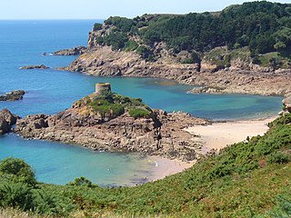
St. Aubin is a town and port in St. Brelade in Jersey, the largest of the Channel Islands. It is located on the western end of St. Aubin's Bay, on the south coast of the island, opening out into the Gulf of Saint-Malo.

Jersey Airport is an international airport located in the parish of Saint Peter, 4 NM west northwest of Saint Helier in Jersey, in the Channel Islands.

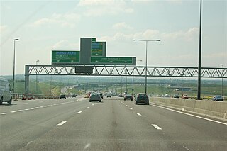
The London Ringways were a series of four ring roads planned in the 1960s to circle London at various distances from the city centre. They were part of a comprehensive scheme developed by the Greater London Council (GLC) to alleviate traffic congestion on the city's road system by providing high speed motorway-standard roads within the capital, linking a series of radial roads taking traffic into and out of the city.

The Jersey Railway was opened in 1870 and was originally a standard gauge railway, 3+3⁄4 miles (6.0 km) long, in Jersey in the Channel Islands. Converted to narrow gauge in 1884 and extended giving a length of 7+3⁄4 miles (12.5 km), the line closed in 1936.

The A201 is an A road in London, England running from Kings Cross to Bricklayer's Arms.

The A202 is a primary A road in London. It runs from New Cross Gate to London Victoria station. A section of the route forms a part of the London Inner Ring Road between Vauxhall and Victoria, known as Vauxhall Bridge Road.
The A1307 is a secondary class A road in Cambridgeshire and Suffolk between the A1(M) near Alconbury and Haverhill, Suffolk. In 2020 the former A14 between North of Cambridge and Alconbury was reclassified as the A1307. Whilst it generally follows the route of the Roman Road Via Devana from Alconbury to Haverhill. As it becomes unroutable through Cambridge, and sections were developed in different decades, it has been delt with in three parts: Cambridge city, Eastern and Northern.

Transport within Leeds consists of road, bus and rail networks. Leeds railway station is one of the busiest in Britain, and Leeds is connected to the national road network via the A1(M) motorway, M1 motorway and M62 motorway. The city is served by Leeds Bradford Airport.
The A9 highway is a major highway in Nigeria, located in the northern region of the country. It serves as a vital transportation link, connecting several key cities and facilitating both domestic and international trade.

The A9 is a Portuguese motorway which, as the name indicates, forms a partial outer circular route beyond the north and western parts of the Lisbon conurbation. It thereby links the Estoril coastal area with principal highways towards the north of the country.

Victoria Avenue is a major road in Jersey, connecting the capital St Helier to Bel Royal in St Lawrence, also providing access to the western part of the A1 for non-bus traffic, due to a bus gate that prevents traffic from the A1 continuing on the A1.
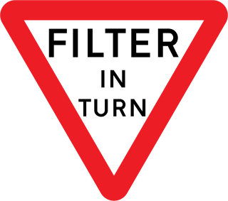
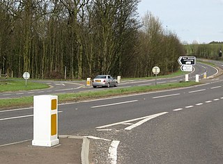
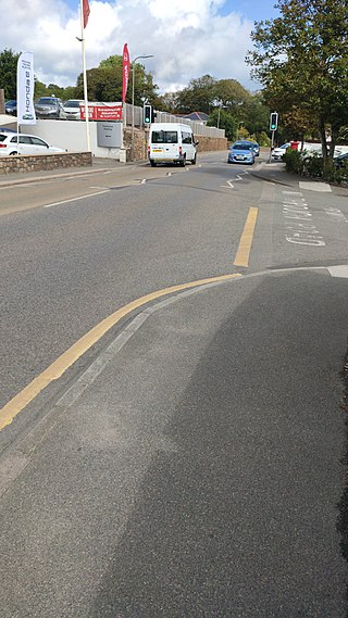
A filter in turn is a type of traffic junction found in the Channel Islands. The basic concept is that vehicles are required to take turns to go through the junction. Filter in turn junctions take slightly different forms across the island.
The A3 is a major road in Jersey connecting Saint Helier and Gorey, passing through Grouville and Longueville.


