A228 road

Last updated

UK road A228.svg
A228
Route information
Length31.1 mi (50.1 km)
Major junctions
North end Lower Stoke
51°27′10″N0°38′07″E / 51.4528°N 0.6352°E / 51.4528; 0.6352 (A228 road (northeastern end))
Major intersectionsUK-Motorway-M2.svg M2
UK-Motorway-M20.svg M20
A2
A20
A21
A26
UK road A264.svg A264
UK road A289.svg A289
South end Pembury
51°08′34″N0°18′23″E / 51.1427°N 0.3065°E / 51.1427; 0.3065 (A228 road (southwestern end))
Location
Country United Kingdom
Primary
destinations
Royal Tunbridge Wells
Maidstone
Rochester
Tonbridge
West Malling
Kings Hill
Snodland
Road network
The embryonic A228 on Grain A228onGrain-by-Richard-Dorrell.jpg
The embryonic A228 on Grain
Bridleway bridge over the new Leybourne Bypass. Leybournebypass-by-David-Anstiss.jpg
Bridleway bridge over the new Leybourne Bypass.
East Peckham bridge over the River Medway. Eastpeckhambypasscrossing.jpg
East Peckham bridge over the River Medway.

The A228 road is an important transport artery in Kent, England. It begins at the Isle of Grain and runs in a south-westerly direction to connect eventually with the A21 trunk road at Pembury. It serves existing communities and new and proposed housing developments and commercial enterprises. The most influential force on the recent upgrading of the road has been the development of Kings Hill near West Malling.

Contents

Route

Grain to M20

The A228 commences on a railway level crossing at Lower Stoke on the Isle of Grain, where it continues as the B2001. It begins as Grain Road, becoming Malmaynes Hall Road after it passes through Stoke running west. Passing High Halstow and turning south, it follows Sharnal Street which then becomes the Ratcliffe Highway, which bypasses Hoo St Werburgh and skirts the Deangate Ridge Golf Club. After reaching Chattenden it turns into Four Elms Hill before switching onto the new Wainscott Eastern Bypass. Entering Frindsbury, where the A289 Medway Towns northern bypass starts, it follows Frindsbury Hill and then Frindsbury Road before reaching Strood. The southern part of this Hoo Peninsula section was widened in 2005 as part of the Thames Gateway development programme. It is intended to dual the northern section to Grain at a later date (provisionally 2016). [1] [ needs update ] [2] [3]

In Strood the southbound and northbound routes split due to Strood's one-way system. The southbound route goes along North Street and then Knight Road before joining the Cuxton Road whilst the northbound route follows Gun Lane from Cuxton Road to Frindsbury Road. In Strood it also crosses the A2. Continuing south, the road passes over the M2 and High Speed 1 on Sundridge Hill where those two routes reach land again after crossing their respective Medway bridges.

Proceeding down Sundridge Hill, the road descends from the Downs and enters the Medway Gap at Cuxton, where it then becomes the Rochester Road and later Formby Road as it makes its way to Halling. At Halling, the A228 departs from the old route that took it through the village and proceeds along the Halling Bypass which then links up with the Snodland Bypass near Holborough.

As the Snodland Bypass ends the road rejoins its historic route (albeit on very recent much enlarged roads) for a short stretch on Malling Road which becomes Castle Way as it approaches Leybourne, [4] meeting the M20 Junction 4.

M20 to Tunbridge Wells

South of the M20, the route again diverts onto a 2006 bypass to the west of the old route village, [5] which then passes under the A20 (a road that it used to meet) and then joins the West Malling Bypass, which was built in 1988 [6] then upgraded to dual carriageway in the 2000s.

Passing Manor Park Country Park to the west and the roundabout at the northern entrance to Kings Hill, the road becomes Ashton Way before meeting the Malling Road at the southern tip of West Malling and proceeding through Mereworth. South of Mereworth, the route is shared by that of the A26 for a short period before the routes diverge upon meeting Seven Mile Lane onto which the A228 turns south while the A26 proceeds southwest to Tonbridge.

As it passes East Peckham and the hamlet of Hale Street, the road becomes Hale Street before crossing the River Medway and joining Bainbridges Road, passing Beltring and The Hop Farm Country Park. Here the road splits with the B2160 branching off south towards Paddock Wood and the A228 turning southwest along the Whetsted Road towards Whetsted, where it becomes the Maidstone Road for its final stretch before reaching Pembury.

This last section is under consideration for another bypass for Colts Hill [7] as this section of road is a relatively small single carriageway which is a notorious accident blackspot [8] and a key link between Maidstone Hospital and the newly redeveloped Pembury Hospital.

The classification A228 was not applied originally to the route south of Mereworth. Following improvements in the 1990s (including a bypass around East Peckham), the B2016 between Mereworth and Hale Street and the B2015 between Hale Street and Pembury were both reclassified as A228.

As it passes through Pembury, the Maidstone Road becomes the Pembury Road towards Tunbridge Wells, and the A228 shares the route of the A264 for its last few yards as it crosses the A21 before finally terminating on a roundabout at the end of the slip roads for the northern bound carriageway of the A21.

Related Research Articles

<span class="mw-page-title-main">Medway</span> Unitary authority in Kent, England

Medway is a unitary authority district and conurbation in Kent, South East England. It had a population of 278,016 in 2019. The unitary authority was formed in 1998 when Rochester-upon-Medway amalgamated with the Borough of Gillingham to form Medway Towns. It is now a unitary authority area run by Medway Council, independent of Kent County Council but still part of the ceremonial county of Kent.

<span class="mw-page-title-main">River Medway</span> River in South East England

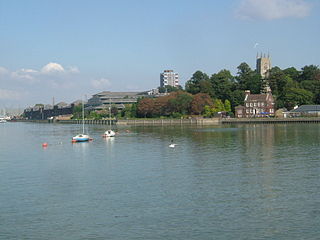
The River Medway is a river in South East England. It rises in the High Weald, East Sussex and flows through Tonbridge, Maidstone and the Medway conurbation in Kent, before emptying into the Thames Estuary near Sheerness, a total distance of 70 miles (113 km). About 13 miles (21 km) of the river lies in East Sussex, with the remainder being in Kent.

<span class="mw-page-title-main">Snodland</span> Human settlement in England

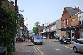
Snodland is a town in the borough of Tonbridge and Malling in Kent, England. It lies on the River Medway, between Rochester and Maidstone, and 27 miles (43 km) from central London. At the 2011 Census, it had a population of 10,211.

<span class="mw-page-title-main">M2 motorway (Great Britain)</span>

The M2 is a motorway in Kent, England. It is 26 miles (42 km) long and acts as a bypass of the section of the A2 road to run past the Medway Towns, Sittingbourne, Faversham, and to provide an alternative route to the Port of Dover, supplementing the M20. It feeds into the A2, forming a 62 mile long trunk road from London to (almost) Dover.

<span class="mw-page-title-main">Tonbridge and Malling</span> Non-metropolitan district in England

Tonbridge and Malling is a local government district with borough status in Kent, England. Tonbridge is the largest settlement but the authority is based in the modern development of Kings Hill.

<span class="mw-page-title-main">A21 road (England)</span> Major road in southern England running from London to Hastings

For other roads with the same name see List of A21 roads.

<span class="mw-page-title-main">Strood</span> Town in Medway in South East England

Strood is a town in the unitary authority of Medway in Kent, South East England. The town forms a conurbation with neighbouring towns Chatham, Rochester, Gillingham and Rainham. It lies on the northwest bank of the River Medway at its lowest bridging point.

<span class="mw-page-title-main">Medway Valley line</span> Railway line in Kent

The Medway Valley line is the name given to the railway line linking Strood in the Medway Towns via Maidstone West to Paddock Wood. High Speed services also link between Maidstone West, Snodland, Strood and London St Pancras International. The section from Maidstone West to Paddock Wood passes through some of Kent's most picturesque countryside along the narrower sections of the River Medway.

<span class="mw-page-title-main">Halling railway station</span> Railway station in Kent, England

Halling railway station is on the Medway Valley Line in Kent, England, and lies a little to the north of the village of Halling. It is 35 miles 18 chains (56.7 km) down the line from London Charing Cross via Strood and is situated between Cuxton and Snodland. The station and all trains that serve the station are operated by Southeastern.

<span class="mw-page-title-main">Snodland railway station</span> Railway station in Kent, England

Snodland railway station is on the Medway Valley Line in Kent, England, serving the town of Snodland which lies some way to the west. It is 36 miles 59 chains (59.1 km) down the line from London Charing Cross via Strood and is situated between Halling and New Hythe. The station and all trains that serve the station are operated by Southeastern.

<span class="mw-page-title-main">Medway (UK Parliament constituency)</span> Parliamentary constituency in the United Kingdom

Medway was a county constituency represented in the House of Commons of the Parliament of the United Kingdom between 1983 and 2010. A previous constituency of the same name existed from 1885 to 1918.

<span class="mw-page-title-main">A26 road</span> Road in England

The A26 road is a primary route in the southeast of England, going from Maidstone to Newhaven through the counties of Kent and East Sussex. The road is almost entirely single carriageway with one lane on each side, although some of the road is three lanes, with the middle lane switching sides for overtaking and right turns.

<span class="mw-page-title-main">East Peckham</span> Village and parish in Kent, England

East Peckham is a village and civil parish in Kent, England on the River Medway. The parish covers the main village as well as Hale Street and Beltring.

<span class="mw-page-title-main">Cuxton</span> Human settlement in England

Cuxton is a village in the unitary authority of Medway in South East England. It lies on the left bank of the River Medway in the North Downs. It is served by the A228, and Cuxton railway station on the Medway Valley Line between Strood and Maidstone. A low valley leads up from the river to the hamlet of Lower Bush.

<span class="mw-page-title-main">Frindsbury Extra</span> Human settlement in England

Frindsbury Extra is a civil parish divided into commercial, suburban residential and rural parts on the Hoo Peninsula in Medway, a ceremonial part of Kent. It is contiguous with the fully urbanised Frindsbury part of Strood and is bounded by Cliffe and Cliffe Woods to the north, Hoo to the east, and the River Medway to the south-east at Upnor and a long, narrow meander of the river in the far south. On Medway Council it has councillors representing the Strood Rural ward currently on almost identical boundaries.

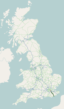
Transportation needs within the county of Kent in South East England has been served by both historical and current transport systems.

References

  1. "UK Government Web Archive". webarchive.nationalarchives.gov.uk. Retrieved 21 March 2023.
  2. "A228 - Roader's Digest: The SABRE Wiki".
  3. "A228 miadstone road & back".
  4. EIS - Graham King. "Kent Parish Councils - Leybourne Parish Council". Leybournepc.kentparishes.gov.uk. Archived from the original on 26 March 2012. Retrieved 4 November 2012.
  5. Factsheet [ permanent dead link ]
  6. Tonbridge and Malling Borough Council https://www.tmbc.gov.uk/downloads/file/1270/west-malling-character-areas-spd-adopted
  7. "Archived copy". www.kent.gov.uk. Archived from the original on 21 August 2008.{{cite web}}: CS1 maint: archived copy as title (link)
  8. "Kent news, views & business listings from Kent's Community". This is Kent. Retrieved 4 November 2012.[ permanent dead link ]
Map all coordinates using: OpenStreetMap  
Download coordinates as: KML

Coordinates: 51°18′12″N0°24′56″E / 51.3034°N 0.4156°E / 51.3034; 0.4156 (A228 road)