List of motorways in the United Kingdom

Last updated

UK motorways in 2022
.mw-parser-output .legend{page-break-inside:avoid;break-inside:avoid-column}.mw-parser-output .legend-color{display:inline-block;min-width:1.25em;height:1.25em;line-height:1.25;margin:1px 0;text-align:center;border:1px solid black;background-color:transparent;color:black}.mw-parser-output .legend-text{}
M-designated motorway
Upgraded A-road designation UK motorways map 2022.svg
UK motorways in 2022
  M-designated motorway
  Upgraded A-road designation

This list of motorways in the United Kingdom is a complete list of motorways in the United Kingdom. Note that the numbering scheme used for Great Britain does not include roads in Northern Ireland, which are allocated numbers on an ad hoc basis. [1]

Contents

Great Britain

M-designated motorways

LinkRoute Ceremonial counties (England)
Council areas (Scotland)
Principal areas (Wales)
Highest junction to junction average daily vehicle flow 2019 [2] Length
mikm
M1 A south-north motorway linking London to Leeds. Greater London, Hertfordshire, Bedfordshire, Buckinghamshire, Northamptonshire, Leicestershire, Nottinghamshire, Derbyshire, South Yorkshire, West Yorkshire 168,763193.5311.4
M2 A west-east motorway bypassing Medway, Sittingbourne and Faversham. Kent 106,58225.741.4
M3 A northeast-southwest motorway linking London to Southampton. Surrey, Hampshire 136,05958.694.3
M4 An east-west motorway linking London to Cardiff and South Wales. Greater London, Buckinghamshire, Berkshire, Wiltshire, Gloucestershire, Monmouthshire, Newport, Cardiff, Vale of Glamorgan, Rhondda Cynon Taff, Bridgend, Neath Port Talbot, Swansea, Carmarthenshire 161,807189304
M5 A northeast-southwest motorway in South West England, linking Birmingham to Exeter. West Midlands, Worcestershire, Gloucestershire, Bristol, Somerset, Devon 127,584162.9262.2
M6 A southeast-northwest motorway linking the West Midlands to North West England. Leicestershire, Warwickshire, West Midlands, Staffordshire, Cheshire, Merseyside, Greater Manchester, Lancashire, Cumbria 173,201232.2373.7
M6 Toll A tolled bypass of the M6 in the West Midlands. West Midlands, Staffordshire, Warwickshire 110,4892743
M8 An east-west motorway linking Edinburgh to Glasgow. Edinburgh, West Lothian, North Lanarkshire, Glasgow, Renfrewshire 160,48460.397.0
M9 A southeast-northwest motorway linking Edinburgh to Stirling. Edinburgh, West Lothian, Falkirk, Stirling 68,14333.053.1
M11 A south-north motorway linking London to Cambridge. Greater London, Essex, Cambridgeshire 121,96455.088.5
M18 A southwest-northeast motorway linking the M1 to the M62. South Yorkshire, East Riding of Yorkshire 108,85526.542.6
M20 A west-east motorway linking London to Folkestone and the Channel Tunnel. Kent 120,34850.681.4
M23 A north-south motorway linking London to Gatwick Airport and Crawley. Surrey, West Sussex 110,57415.925.6
M25 A ring road of London numbered clockwise from Dartford. Kent, Surrey, Berkshire, Greater London, Buckinghamshire, Hertfordshire, Essex 216,108117188
M26 An east-west motorway linking the M25 to the M20. Kent 70,6749.915.9
M27 A west-east motorway linking Southampton to Portsmouth. Hampshire 134,21025.040.2
M32 A spur from the M4 into central Bristol. Gloucestershire, Bristol 84,8984.47.1
M40 A southeast-northwest motorway linking London to Birmingham. Buckinghamshire, Oxfordshire, Northamptonshire, Warwickshire 133,49089.0143.2
M42 Bypasses Birmingham to the south and east, continuing to Kegworth as the A42. Worcestershire, Warwickshire, West Midlands, Leicestershire 154,532 40.064.4
M45 A spur from the M1 to Rugby. Warwickshire, Northamptonshire 19,536 7.912.7
M48 An alternative route to the M4 between Bristol and Caldicot. Gloucestershire, Monmouthshire 22,632 1219
M49 Bypasses Bristol to the west. Bristol, Gloucestershire 22,461 5.08.0
M50 A west-east motorway between the M5 and Ross-on-Wye. Worcestershire, Gloucestershire, Herefordshire 32,032 21.634.8
M53 A north-south motorway linking central Liverpool to Chester. Merseyside, Cheshire 79,872 18.930.4
M54 An east-west motorway linking Wolverhampton to Telford. Staffordshire, Shropshire 70,652 23.037.0
M55 An east-west motorway linking Preston to Blackpool. Lancashire 84,90512.219.6
M56 A west-east motorway linking Manchester to Liverpool and Chester. Greater Manchester, Cheshire 174,69333.353.6
M57 An eastern bypass of Liverpool linking the M62 to Maghull. Merseyside 99,5211016
M58 A west-east motorway linking Liverpool to Wigan. Merseyside, Lancashire, Greater Manchester 49,3761219
M60 A ring road of Manchester numbered clockwise from Stockport. Greater Manchester 180,5013658
M61 A north-south motorway linking Preston to Manchester. Greater Manchester, Lancashire 150,331 20.032.2
M62 A west-east motorway linking Liverpool to Hull. Merseyside, Cheshire, Greater Manchester, West Yorkshire, North Yorkshire, East Riding of Yorkshire 161,700 107172
M65 A west-east motorway linking Preston to Colne. Lancashire 82,970 25.841.5
M66 A north-south motorway linking Ramsbottom to Manchester. Lancashire, Greater Manchester 111,851 8.012.9
M67 A west-east motorway linking Manchester to Hadfield. Greater Manchester 58,435 5.08.0
M69 A northeast-southwest motorway linking Leicester to Coventry. Warwickshire, Leicestershire 64,828 15.725.3
M73 An eastern bypass of Glasgow. North Lanarkshire, Glasgow, South Lanarkshire 95,3317.011.3
M74 A northwest-southeast motorway linking Glasgow to North West England. Continues as the A74(M) south of Abington. Glasgow, North Lanarkshire, South Lanarkshire 107,475 4060
M77 A north-south motorway linking Glasgow to Kilmarnock. Glasgow, East Renfrewshire, East Ayrshire 94,151 20.032.2
M80 A southwest-northeast motorway linking Glasgow to Stirling. Glasgow, North Lanarkshire, Falkirk, Stirling 104,30525.040.2
M90 A south-north motorway linking Edinburgh to Perth. Edinburgh, Fife, Perth and Kinross 76,503 36.057.9
M180 A west-east motorway linking Thorne to Grimsby. Continues as the A180 after the exit for the Humber Bridge. South Yorkshire, Lincolnshire 48,780 25.040.2
M181 A spur of the M180 leading to Scunthorpe. Lincolnshire 18,213 2.03.2
M271 A spur of the M27 bypassing Southampton to the west. Hampshire 53,678 2.33.7
M275 A spur from the M27 to central Portsmouth.86,2912.03.2
M602 A west-east motorway linking the M62 to Salford. Greater Manchester 73,292 4.06.4
M606 A spur from the M62 to Bradford. West Yorkshire 77,277 3.04.8
M621 An east-west motorway linking Leeds to the M1 and M62.103,207 7.712.4
M876 A southwest-northeast motorway linking Bonnybridge to Kincardine. Falkirk 42,611 8.012.9
M898 A spur from the M8 leading to Erskine Bridge. Renfrewshire 51,8310.50.8

Upgraded A-road designations

LinkRoute Ceremonial counties (England)
Council areas (Scotland)
Principal areas (Wales)
Highest junction to junction average daily vehicle flow 2019 [2]
A1(M) A south-north motorway split into four sections: Hertfordshire, Bedfordshire, Cambridgeshire, Nottinghamshire, South Yorkshire, West Yorkshire, North Yorkshire, County Durham, Tyne and Wear 143,012
A3(M) A north-south motorway linking the A3 to the A27 near Portsmouth. Hampshire 92,989
A8(M) A spur from the M8 and M73 to Ballieston. Glasgow 10,586
A38(M) A spur from the M6 to central Birmingham. West Midlands 146,908
A48(M) A spur from the M4 to central Cardiff. Newport, Cardiff 47,203
A57(M) Forms part of a ring road of Manchester. Also known as the Mancunian Way. Greater Manchester 90,785
A58(M) Forms the western part of the Leeds inner ring road. West Yorkshire 81,647
A64(M) Forms the eastern part of the Leeds inner ring road.43,617
A66(M) A spur from the A1(M) to the A66 near Darlington. North Yorkshire 15,337
A74(M) A northwest-southeast motorway linking the M74 to North West England. Continues as the M6. South Lanarkshire, Dumfries and Galloway, Cumbria 41,662
A167(M) An urban motorway in Newcastle-Upon-Tyne. Tyne and Wear 63,911
A194(M) A south-north motorway linking the A1(M) to the Tyne Tunnel.42,802
A308(M) A spur from the M4 to Bray. Berkshire 23,541
A329(M) A southeast-northwest motorway linking Bracknell to Reading.69,520
A404(M) A spur from the M4 to High Wycombe. Continues as the A404 west of Maidenhead.59,816
A627(M) A south-north motorway linking Rochdale to Chadderton. Greater Manchester 55,749
A823(M) A spur from the M90 to Dunfermline. Fife 20,363
A1077(M) A spur from the M181 to Scunthorpe. Lincolnshire 18,213

Former motorways

Roads which used to be motorways but have been downgraded:

LinkDescription
M10 A short spur northwest bound and southeast bound linking St Albans to the M1 near Hemel Hempstead. After 50 years as a motorway spur, it was downgraded to the A414 in 2009 due to widening of the M1 between the M25 and Luton.
M15 The designation for the Ringway 2 upgrade of the A406 (North Circular Road) and A205 (South Circular Road). Only the section between junction 4 of the M11 and Redbridge Roundabout was built to motorway standard and was initially signed as M11 because the section built, at the time, only led to and from the M11. When the route was extended to Beckton, this section of M11 was redesignated as the A406 (North Circular Road).
M41 The London West Cross Route, a spur from the London Westway (A40(M)) and the only part of the western section of the London Motorway Box to be built; downgraded to the A3220 in 2000. [3]
A36(M)Claimed number for the spur at M27 J2. Initially part of the M27 until the Totton Western Bypass opened after which it was downgraded to an extension of the A36. The A36(M) designation was never used; the route was simply named as a spur of the M27.
A40(M) The London Westway, downgraded to the A40 in 2000. [3]
A41(M)The Tring bypass, downgraded to the A41 in 1987.
A46(M)A spur towards Leicester from the M1 at J21. Downgraded to the A5460 in 1976 due to completion of the M69.
A102(M) The London East Cross Route, in two sections:
A329(M) The northern third of the A329(M) from Winnersh to Reading was downgraded to the A3290 in the early 1990s to permit Reading council to dedicate one lane for buses.
A601(M) The southern part (single carriageway link to the B6254) is now the B6601. Downgraded in 2020 to enable access to adjacent development. [4] The remainder of the route was downgraded to the A6070 in 2023. [5]
A6144(M) Formerly the longest single-carriageway motorway spur in the United Kingdom from the M60 north of Sale towards Carrington. Downgraded to a spur of the A6144 in 2006.

Motorways that have been renumbered

LinkDescription
M16 Northern and western sections of Ringway 3; completed sections are now part of the M25.
M52Planned as a Liverpool-to-Manchester motorway; nearly all of it opened as part of the M62 cross-country route, and a short section as the M64 (later M602) in Manchester.
M62 Originally planned to be the western loop around Manchester and Salford; became part of the M63 before the western extension of the M62 was opened; now the M60 J7-J13.
M63 Manchester South Orbital; merged with parts of the M62 and M66 in 1998 to form the new M60 Manchester orbital motorway.
M64Eccles Bypass, formerly part of the M52; it was not considered important enough to carry a two-digit number (and it had not yet opened) and was redesignated as M602.
M65 Gildersome to Leeds Motorway; not considered important enough (and it had not yet opened) to carry a two-digit number, it was redesignated as M621.
M68Allocated to the southern and eastern sections of the Manchester Outer Ring Road. The eastern section became a portion of the M66 when it opened north of the M62 in the early 1970s and was renumbered to M60 J18-19 in 1998 while the southern section was eventually dropped altogether by 2010.
M85Renumbered to M90 J10-11 in 1994. Previously the M90 carried on along the spur into Perth, leaving the main route ahead as the M85.
M531Ellesmere Port Motorway; was the A5032 before 1975. Now the M53 J5-10.
A1(M) Central Motorway East; became the A6127(M) when the A1 was rerouted to run through the Tyne Tunnel. Now the A167(M).
A2(M)Provisional number for the Medway Motor Road, a bypass of Chatham, Gillingham and Rochester. Changed to M2 as a result of an article in the 15 December 1959 edition of The Daily Telegraph.
A4(M)Maidenhead Bypass; became a portion of the M4 and later part of the A423(M). Now the A404(M). A small section was abandoned.
A5(M)Provisional number for the Wellington Bypass, redesignated as the M54 before construction was complete.
A8(M) Provisional number for the Renfrew Bypass, now part of the M8.
A14(M)Secretive (unsigned) motorway linking the A14 and A1(M) near Huntingdon. Documents referred the route as A14(M) or A604(M). Became a part of A1(M) when the A14(M) designation was moved to the Huntingdon-Cambridge section of the A14.
A18(M) A spur from the M18 to the A18 north of Doncaster. Mostly now part of the M180, although a section has been abandoned.
A20(M)Maidstone Bypass; now the M20 J5-8.
A21(M)Disputed, secret number for the section of the A21 Sevenoaks bypass that became the M25 in 1986.
A23(M)Original number of the M23.
A40(M)Provisional number for the High Wycombe and Beaconsfield bypasses. The Beaconsfield bypass was changed to M40 before it opened. It is not clear when the High Wycombe bypass was renumbered, but it too is now the M40.
A48(M) Morriston Bypass; now the M4 J44-46.
A48(M) Port Talbot Bypass; now the M4 J39-41.
A50Provisional number for the M1.
A62(M)Original designation for the Leeds Southeastern Urban Motorway, now the M621.
A65(M)Erroneous designation for the A64(M), either a map error or a deliberate trap street.
A185(M)Map error for A194(M), appearing in a 1969 map. Number officially never used.
A423(M)Originally A4(M) and then part of the M4. Now the A404(M).
A446(M)Provisional number for the M6 Toll.
A638(M)Provisional number for the M606.
A1231(M)Unsigned spur from the A1(M) near Washington services. Now part of the A195(M), also unsigned.
A6127(M)Originally A1(M); now the A167(M).

Motorways under construction or planned

The Adwick-le-Street to M62 stretch of the A1 is under consideration for upgrade to motorway standard, meaning the A1 between Blyth, south of Doncaster, to Birtley near Gateshead, would all be part of the same A1(M) stretch of motorway.

In addition, the proposal to put a tunnel under the River Thames to the east of Dartford Crossing and the revived Birmingham Western Orbital plans are both described as motorways. [6] [7]

Unbuilt motorways

There have been many plans for motorways in the UK that have not been built. Below is a. non-exhaustive list of plans that were not built:

Many cities had urban motorway plans, most of which were not built. London, [14] Newcastle, [15] Liverpool, [16] Manchester/SELNEC and Glasgow [16] all had extensive plans.

Northern Ireland

M-designated motorways

LinkRoute Council areas
M1 Linking Belfast to Dungannon. Belfast, Lisburn and Castlereagh, Armagh City, Banbridge and Craigavon, Mid Ulster
M2 In two sections, one linking Belfast to Antrim, and the other bypassing Ballymena. The section in between was planned, but never built. Belfast, Antrim and Newtownabbey, Mid and East Antrim
M3 Linking the M2 in north Belfast to the A2 Sydenham Bypass in east Belfast. Belfast
M5 Linking the M2 in north Belfast to Newtownabbey. Belfast, Antrim and Newtownabbey
M12 A spur from the M1 near Derrymacash to the north of Portadown. Armagh City, Banbridge and Craigavon
M22 Linking the M2 at Antrim to Randalstown. Antrim and Newtownabbey

Upgraded A-road designations

LinkRoute Council areas
A8(M) A spur from the M2 near Glengormley to the A8 north-west of Newtownabbey. Antrim and Newtownabbey

Unbuilt motorways

The following motorways were planned, but never built:

There were also urban motorway plans for Belfast. [18] [17]

See also

Notes

  1. "Northern Ireland Assembly – WRITTEN ANSWERS Friday 15 December 2000". Archived from the original on 23 December 2008. Retrieved 19 November 2007.
  2. 1 2 "GB Road Traffic Counts". Archived from the original on 1 October 2019. Retrieved 13 January 2019.
  3. 1 2 3 Under its charter, motorways are excluded from the remit of Transport for London. These routes had their motorway status removed to allow TfL control over them.
  4. "The Lancashire County Council (A601(M) Partial Revocation) Scheme 2019 Confirmation Instrument 2020".
  5. "The end of the A601(M) | Roads.org.uk". www.roads.org.uk. Retrieved 21 March 2023.
  6. "Lower Thames Crossing Statutory Consultation - Highways England - Citizen Space". highwaysengland.citizenspace.com.
  7. Elkes, Neil (6 June 2018). "Revealed: New bypass plan to end M6 and M5 traffic misery". birminghammail.
  8. "A556 Knutsford to Bowden improvement scheme". costain.com.
  9. "TransPennine: "Go the whole way, complete the M67, with a tunnel underneath"". 9 November 2014.
  10. "A road to the past: Salford's unbuilt motorway that would have destroyed landmarks and neighbourhoods". Salford Now. 7 March 2023.
  11. "Plans for part of A14 upgrade to become a motorway". GOV.UK. Retrieved 7 October 2018.
  12. "New A14 bypass to open a year early". GOV.UK. Retrieved 5 December 2019.
  13. "EuroRoute". Roads.org.uk.
  14. CBRD Histories: London Ringways Archived 18 November 2012 at the Wayback Machine
  15. "Pathetic Motorways". pathetic.org.uk.
  16. 1 2 "Articles". Roads.org.uk.
  17. 1 2 3 4 5 6 7 "History - Northern Ireland Motorway Plans - Northern Ireland Roads Site". www.wesleyjohnston.com.
  18. "History - Belfast Urban Motorway and A12 Westlink - Northern Ireland Roads Site". www.wesleyjohnston.com.

Related Research Articles

<span class="mw-page-title-main">M11 motorway</span> Motorway in England

The M11 is a 55 miles (89 km) motorway that runs north from the North Circular Road (A406) in South Woodford to the A14, northwest of Cambridge, England. Originally proposed as a trunk road as early as 1915, various plans were considered throughout the 1960s, with final construction being undertaken between 1975 and 1980. The motorway was opened in stages, with the first stage between junctions 7 and 8 opening in June 1975, and the completed motorway becoming fully operational in February 1980. Running from Woodford to Girton, the motorway provides direct access to Harlow, Cambridge and since 2002, greatly improved access to London Stansted Airport.

<span class="mw-page-title-main">M6 motorway</span> Longest motorway in England

The M6 motorway is the longest motorway in the United Kingdom. It is located entirely within England, running for just over 230 miles (370 km) from the Midlands to the border with Scotland. It begins at Junction 19 of the M1 and the western end of the A14 at the Catthorpe Interchange, near Rugby before heading north-west. It passes Coventry, Birmingham, Wolverhampton, Stoke-on-Trent, Preston, Lancaster and Carlisle before terminating at Junction 45 near Gretna. Here, just short of the Scottish border it becomes the A74(M) which continues to Glasgow as the M74. Its busiest sections are between junctions 4 and 10a in the West Midlands, and junctions 16 to 19 in Cheshire; these sections have now been converted to smart motorways.

<span class="mw-page-title-main">M1 motorway</span> First inter-urban motorway in the UK

The M1 motorway connects London to Leeds, where it joins the A1(M) near Aberford, to connect to Newcastle. It was the first inter-urban motorway to be completed in the UK; the first motorway in the country was the Preston Bypass, which later became part of the M6.

<span class="mw-page-title-main">M62 motorway</span> Motorway in the United Kingdom

The M62 is a 107-mile-long (172 km) west–east trans-Pennine motorway in Northern England, connecting Liverpool and Hull via Manchester, Bradford, Leeds and Wakefield; 7 miles (11 km) of the route is shared with the M60 orbital motorway around Manchester. The road is part of the unsigned Euroroutes E20 and E22.

<span class="mw-page-title-main">M50 motorway (Ireland)</span> Orbital motorway around Dublin

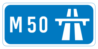
The M50 motorway is a C-shaped orbital motorway in Dublin and the busiest motorway in Ireland. The current route was built in various sections over the course of 27 years, from 1983 to 2010. It begins at Dublin Port, running northward through the Dublin Port Tunnel and along a portion of the Airport Motorway. It then turns west at its junction with the M1, circling the northern, western and southern suburbs of Dublin, before merging with the M11 at Shankill in South East Dublin. The road forms part of European route E01.

<span class="mw-page-title-main">M56 motorway</span> Motorway in England

The M56 motorway serves the Cheshire and Greater Manchester areas of England. It runs east to west from junction 4 of the M60 at Gatley, south of Manchester, to Dunkirk, approximately four miles north of Chester. With a length of 33.3 miles (53.6 km), it connects North Wales and the Wirral peninsula with much of the rest of North West England, serves business and commuter traffic heading towards Manchester, particularly that from the wider Cheshire area, and provides the main road access to Manchester Airport from the national motorway network.

<span class="mw-page-title-main">A14 road (England)</span> Major road in England

The A14 is a major trunk road in England, running 127 miles (204 km) from Catthorpe Interchange, a major intersection at the southern end of the M6 and junction 19 of the M1 in Leicestershire to the Port of Felixstowe, Suffolk. The road forms part of the unsigned Euroroutes E24 and E30. It is the busiest shipping lane in East Anglia carrying anything from cars to large amounts of cargo between the UK and Mainland Europe.

<span class="mw-page-title-main">Roads in Ireland</span> Overview of roads in Ireland

The island of Ireland, comprising Northern Ireland and the Republic of Ireland, has an extensive network of tens of thousands of kilometres of public roads, usually surfaced. These roads have been developed and modernised over centuries, from trackways suitable only for walkers and horses, to surfaced roads including modern motorways. Driving is on the left-hand side of the road. The major routes were established before Irish independence and consequently take little cognisance of the border other than a change of identification number and street furniture. Northern Ireland has had motorways since 1962, and has a well-developed network of primary, secondary and local routes. The Republic started work on its motorway network in the early 1980s; and historically, the road network there was once somewhat less well developed. However, the Celtic Tiger economic boom and an influx of European Union structural funding, saw national roads and regional roads in the Republic come up to international standard quite quickly. In the mid-1990s, for example, the Republic went from having only a few short sections of motorway to a network of motorways, dual carriageways and other improvements on most major routes as part of a National Development Plan. Road construction in Northern Ireland now tends to proceed at a slower pace than in the Republic, although a number of important bypasses and upgrades to dual carriageway have recently been completed or are about to begin.

<span class="mw-page-title-main">N11 road (Ireland)</span> National primary road in Ireland

The N11 road is a national primary road in Ireland, running for 129 km (80 mi) along the east side of Ireland from Dublin to Wexford. It passes close to Bray, Greystones, Wicklow, Arklow, Gorey, and Enniscorthy. Beyond Wexford, the route continues to Rosslare as the N25. The road forms part of European route E01. As of July 2019 the N11/M11 is of dual carriageway or motorway standard from Dublin as far as Oilgate in County Wexford.

<span class="mw-page-title-main">Spur route</span> Short road forming a branch from a freeway, Interstate Highway, or motorway

A spur route is a short road forming a branch from a longer, more important road such as a freeway, Interstate Highway, or motorway. A bypass or beltway is not considered a spur route as it typically reconnects with another or the same major road.

<span class="mw-page-title-main">National Development Plan</span> Large infrastructure developments in Ireland

National Development Plan is the title given by the Irish Government to a scheme of organised large-scale expenditure on (mainly) national infrastructure. The first five-year plan ran from 1988 to 1993, the second was a six-year plan from 1994 to 1999 and the third ran as a seven-year plan from 2000 to 2006. A fourth National Development Plan ran from 2007 to 2011. The main elements of the third plan were the development of a national motorway network between the major cities in Ireland. The upgrading of the rail network was a secondary scheme.

<span class="mw-page-title-main">A54 road</span> Road in England

The A54 road is a road in England linking Chester in Cheshire with Buxton in Derbyshire. Its route through both urban and steep rural areas presents a challenge to Cheshire County Council in maintaining the safety of the road. Many years ago it was the main east–west route in Cheshire. The importance of the A54 through Middlewich and Winsford decreased in the 1970s and 1980s with the building of the M56 motorway and dualling of the A556 at Northwich. The section through Winsford carries approximately 30,000 vehicles per day.

<span class="mw-page-title-main">M63 motorway</span> Former road designation in Greater Manchester, England

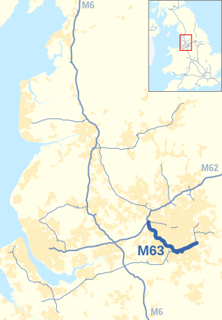
The M63 motorway was a major road in the United Kingdom. It was completely renumbered, in 1998, to become a substantial part of the M60 motorway which orbits part of Greater Manchester.

<span class="mw-page-title-main">East Cross Route</span> Road in East London

East Cross Route (ECR) is a dual-carriageway road constructed in east London as part of the uncompleted Ringway 1 as part of the London Ringways plan drawn up the 1960s to create a series of high speed roads circling and radiating out from central London. The road was constructed between 1967 and 1973 and runs from Hackney Wick in north-east London, through the Blackwall Tunnel, to Kidbrooke in south-east London. The ECR was initially designated as part of the A102, but has, subsequently, been partially renumbered so that sections of it are now the A2 and A12.

<span class="mw-page-title-main">London Ringways</span> Series of proposed ring roads around London

The London Ringways were a series of four ring roads planned in the 1960s to circle London at various distances from the city centre. They were part of a comprehensive scheme developed by the Greater London Council (GLC) to alleviate traffic congestion on the city's road system by providing high-speed motorway-standard roads within the capital, linking a series of radial roads taking traffic into and out of the city.

<span class="mw-page-title-main">A556 road</span> Road in Cheshire

The A556 is a road in England which extends from the village of Delamere in Cheshire West and Chester to the Bowdon Interchange in Cheshire East, bordering Greater Manchester. The road contains a mixture of single and dual carriageway sections and forms a large part of the route between Manchester and Chester. It also acts as a major access route to Chester/North Wales to the west and to Manchester to the east for the conurbation of towns and villages around the Dane Valley centering on Winsford and Northwich. The central part, which forms the Northwich Bypass between Davenham and Lostock Gralam, suffers because of the amount of commuter traffic from this area. The part of the route between the M6 motorway Junction 19 and the M56 motorway Junction 7 is a major route into Manchester and has been recently upgraded to a four-lane dual carriageway.

<span class="mw-page-title-main">Motorways in the Republic of Ireland</span>

In Ireland, the highest category of road is a motorway, indicated by the prefix M followed by a one- or two-digit number. The motorway network consists entirely of motorway-grade dual carriageways and is largely focused upon Dublin. There are also several three-lane motorways, while Ireland's busiest road, the M50, incorporates four-lane, five-lane, and six-lane stretches.

<span class="mw-page-title-main">Smart motorway</span> Designation of roads in the United Kingdom

A smart motorway, also known in Scotland as an intelligent transport system, is a section of motorway in the United Kingdom that employs active traffic management (ATM) techniques to increase capacity through the use of MIDAS technology including variable speed limits and occasionally hard shoulder running and ramp metering at busy times. They were developed at the turn of the 21st century as a cost-effective alternative to traditional carriageway widening, with intended benefits ranging from more reliable journey times to lower vehicle emissions. However, despite the risk of a collision occurring between two moving vehicles being found to be decreased, there has been an acknowledged rise in the incidence of collisions involving vehicles where at least one was stationary in the first few years following the widespread removal of the hard shoulder on the country's busiest sections of motorway. Smart motorways garnered intense criticism from politicians, police representatives and motoring organisations, particularly from 2020 onwards, after a surge in near miss incidents and dozens of fatalities were revealed, and as of April 2023, no new smart motorways will be built.