List of A roads in zone 8 in Great Britain starting north of the A8 and west of the A9 (roads beginning with 8).
List of A roads in zone 8 in Great Britain starting north of the A8 and west of the A9 (roads beginning with 8).
| Road | From | To | Notes |
|---|---|---|---|
| Greenock | Edinburgh | 25-mile (40-kilometre) gap between Newbridge and Newhouse | |
| Glasgow | Moodiesburn | ||
| Glasgow | Callander | ||
| Glasgow | Inverness | ||
| Tarbet | Campbeltown | ||
| Stirling | Lochearnhead | ||
| Oban | Dundee | ||
| Spean Bridge | Kingussie | ||
| Invergarry | Uig | Originally ended in Kyle of Lochalsh; extended over part of the A850 and all of the A856 in 1995. | |
| Larbert | Stenhousemuir | Shortest two-digit road in the UK. Previously allocated to a road from Inverness to Scrabster; this became part of an extended A9 (the section north of Latheron as now part of the A99) and the rest was renumbered the A882 (the section north of Georgemas is now part of the A9) | |
| Glasgow | Newbridge |
| Road | From | To | Notes |
|---|---|---|---|
| Bathgate | Westfield | ||
| East Whitburn | Polmont | ||
| Unused | Ran from Buchanan Street in Glasgow to A8 (now Westmuir Street) in Parkhead. Declassified in the 1970s. | ||
| Glasgow | Champany, Falkirk | ||
| Glasgow | Dumbarton | Mostly incorporated by A82 and A814. Previously allocated to Sauchiehall Street and Parliamentary Road (now gone due to gentrification of central Glasgow and Townhead in the 1960s) from Argyle Street (then the A814) to the A803; this was declassified when the M8 started construction, and the A804 was moved to its current route. | |
| Unused | Ran from Argyle Street (then the A82) via Buchanan Street (southern section now pedestrianized; north section now gone, replaced by Glasgow Royal Concert Hall and a parking garage) to the A81. Became part of a rerouted A82 (the Argyle Street section of the A82 became part of the A814) in 1935 and was declassified in the 1960s-1970s. | ||
| Kirkintilloch | Stepps | Created in 2010 as a renumbering and extension of the A8006. Previously allocated to a road from A81 north of Anniesland to Scotstoun; this is now the A739 and the unclassified Anniesland Road. | |
| Torrance | Milngavie | ||
| Bearsden | Bearsden | ||
| Bearsden | A811 near Croftamie and Drymen | ||
| Bearsden | Duntocher | ||
| Balloch | Stirling | Swapped with the A813 when the A82 bypass was built. | |
| Dennystown | Renton | The original route was on Bank Street and Bridge Street in Alexandria from Main Street (then A82) to A811 (now A813); this became part of a rerouted A82 and the road was reassigned to the old route of the A82; the section from the A82 to Bridge Street became part of the B857 when the A82 was rerouted onto the bypass. | |
| Dumbarton | Balloch | Swapped with the A811 when the A82 bypass was built, and also replaced the old route of the A82 (this section was originally also part of the A811) south of Bridge Street; formerly continued north to Balloch Road. | |
| Glasgow | Arrochar | Incorporates the Clydeside Expressway in Glasgow | |
| Cairndow | Toward | Is the main road through the Cowal peninsula, goes through Dunoon and down the Firth of Clyde coast to Toward Point. | |
| Lochgilphead | Oban | Planned to be replaced by the A85 in the 1935 renumbering, but this never happened. The southern section along Bishopton Road, Oban Road, and Argyll Street was formerly part of the A817. | |
| Loch Lomondside | Garelochhead | Designated 1995, but built in 1987 to connect the Clyde submarine bases to the A82. Previously allocated to a road from Poltalloch Street to Bishopton Road in Lochgilphead. Became a portion of the A816 between 1981 and 1995. | |
| Arden | Helensburgh | Created in 2005, replacing the B831 and the southern section of the B832. Originally ran from the A83 in Campbelltown to the pier; now part of the B842. | |
| Inveraray | Lochawe | ||
| Dunblane | Doune | ||
| Braeval (Aberfoyle) | Kilmahog | ||
| Greenloaning | Inver | ||
| Rosyth | Muthill | Section between Inverkeithing and Rosyth has motorway status as the A823(M). | |
| Muirton (Auchterarder) | Aberuthven | ||
| Corran | Ardgour | Corran Ferry; the roads on either side are part of the A861. Number assigned by Highland Council in 2014. First used from A822 to A85 in Crieff. Renumbered as the A822 mainline (not a spur) in 1934; the section along Lodge Street was probably declassified at the same time. Next used on a road from Gourock to Gourock ferry terminal (not shown on a 1976 OS map but does appear on a 1978 version). In 1985, the A8 and A78 were rerouted in the area, creating the A770. The rerouting of the A8 would have put the A825 out of zone, and it was renumbered to A771. | |
| Milton | Aberfeldy | ||
| Ballinluig | Mid Lix | ||
| Connel | Ballachulish | ||
| Unused | Ran from Glen Coe via Kinochlemore to North Ballachulish; became part of the A82 in 1934 when it was rerouted to avoid the ferry across Loch Leven, and then the B863 in 1975 when the A82 was rerouted to the Ballachulish Bridge. One map shows a second A829 on the old route of the A82 from North Ballachulish south to the ferry (now the bridge), but this was likely a misprint for the A828 extension (this section is now part of the A82). | ||
| Fort William | Mallaig | ||
| Drumnadrochit | Beauly Firth | ||
| Cromarty | A835 near Braemore | ||
| Milton | Balchraggan | Formerly the B854 before it was upgraded to Class I status. Previously allocated to a road from Muir of Ord to Cromarty. This became an extension of the A832 in 1935 because the A833 was put out of zone by the A9 extension over the A88. | |
| Dingwall | Contin | ||
| A9 and A832 near Tore | Ledmore | Primary route to Stornoway car ferry at Ullapool | |
| Tain | John o' Groats | ||
| Inveran | Lochinver | ||
| Lairg | Tongue | ||
| Near Golspie | Rosehall | ||
| Unused | Ran from A882 (now A9) in Thurso to the Thurso railway station. Became a portion of the B874 by 1967. | ||
| Lochranza | Largymore | On the Isle of Arran. Originally circled around the entire island, but now only the northern and eastern sections still exist (but there may still be signage up); the southern and western sections were declassified in the early 2000s. | |
| Unused | Ran from Brodick to Blackwaterfoot. Downgraded to the B880 in the late 1920s, while the western section became part of the A841, now unclassified. | ||
| Unused | Ran from Dippen to A842 (now B880) east of Blackwaterfoot. Became part of the A841 in the late 1920s, and is now unclassified. | ||
| Rothesay | |||
| Unused | Ran from Rothesay to Ambrismore. Downgraded to a northern extension of the B881. | ||
| Lussagiven | Ardbeg, Islay | ||
| Bridgend | Portnahaven | ||
| Mull | Tobermory | ||
| A848 at Salen | Fionnphort | ||
| Dunvegan Castle | A87 | Originally ended at Kyleakin; this is now part of the A87. | |
| Armadale | A87 | ||
| Unused | Ran from the A851 at Isleornsay to the pier. Declassified in the 1980s and now the C1246; there was one sign still showing A852 until 2010. | ||
| Unused | Ran from Armadale to Ardvasar. Declassified in the 1980s and now part of the C1244; there is still one ADS showing A853. | ||
| Unused | Ran from Broadford to Corry Pier. Later declassified, but is now the U5002. | ||
| Portree | Uig | ||
| Unused | Ran from A850 in Borve to Uig. Became an extension of the A87 in 1995 when the Skye Bridge was opened. | ||
| Stornoway, Isle of Lewis | Port Nis, Isle of Lewis | ||
| Stornoway, Isle of Lewis | Barabhas, Isle of Lewis | via Carloway | |
| Stornoway, Isle of Lewis | Rodel, Isle of Harris | Previously allocated to a road from Callanish to Barvas; this became part of the B896 (and is now part of the A858) at the same time the current A859 was created. | |
| Unused | Ran via the Great Cumbrae Island Circle. Downgraded to the B896. | ||
| A830 near Kinlocheil | A830 at Lochailort | direct route along A830 is 14 miles (23 kilometres), this road covers 70 miles (110 kilometres) | |
| Inverness | Ardullie | Previously allocated to a road from Inverness to Fort Augustus (now B862); the number was reused on the old route of the A9 when the A9 bypass was opened | |
| Dunvegan | A87 | ||
| Unused | Ran from A863 east of Lonmore north to A850, with a spur west to the A863. Downgraded in the mid 1980s and is now the C1245. There is still at least one sign showing A864. | ||
| North Uist | Lochboisdale | ||
| Stornoway, Isle of Lewis | Portnaguran, Isle of Lewis | ||
| Clachan na Luib | Sruth Mor | ||
| A859 just outside Tarbert, Isle of Harris | Tarbert car ferry terminal, Isle of Harris | ||
| Unused | Ran from A870 (now B8086) west of Scalasaig to Garvard. Downgraded to Class II status as the B8085 by 1993. | ||
| Unused | Ran from Scalasaig to Kiloran on the western side of the Isle of Colonsay. Downgraded to Class II status as the B8086 by 1993. | ||
| Unused | Ran from Scalasaig to Kiloran on the eastern side of the Isle of Colonsay. Downgraded to Class II status as the B8087 by 1993. | ||
| Dennyloanhead | Stirling | Previously allocated to a road from Corran to Ardgour; this became a spur of the A861, while the actual ferry became the A825 in 2014. | |
| Nyadd | Blairhoyle | ||
| Unused | Was a short road in Balloch along Carrocan road from Miller Road to Balloch Road (became part of the A811 and A813). Previously allocated to another road, but it is unknown where the original road with this number was. | ||
| Baptiston near Killearn | Kepculloch near Balfron | ||
| Airth | Kincardine | Previously incorporated the Kincardine Bridge, but now incorporates the Clackmannanshire Bridge. Previously allocated to a road from Glasgow to Bowling (now part of the A82; the old route of the A82 east of Bowling is now part of the A814) | |
| Renfrew (A741 at Town Hall) | Renfrew (A8) | ||
| Old Kilpatrick | Station Road | ||
| Glasgow | A807 near Bardowie | ||
| A815 near Ardbeg | Blairmore, Argyll | ||
| Unused | Ran from Broadford to Elgol. Downgraded to the B8083 between 1988 and 1993. | ||
| Wick | Georgemas | Section north of Georgemas became part of the A9. Previously allocated to a road from Wick via John o' Groats to Thurso; this became part of the A9 (now A99) and A836, while the number was reused as a renumbering of the section of the A88 that did not become part of the A9. | |
| Falkirk | Denny | ||
| Achnalea | Lochaline | ||
| Sandbank | Dunoon | Known as the High Road, locally. | |
| Port Bannatyne | Strachur | ||
| Invermoriston | Bun Loyne | ||
| Barra | Road circles around the Isle of Barra | ||
| Dalwhinnie | Laggan | ||
| Auchtertyre | Achnasheen | ||
| Strathblane | Auchinreoch | ||
| Unused | Ran from A81 south of Callander to A821 (now Invertrossachs road); originally the B828 before it was upgraded to Class I status. Declassified by 1981; the section south of Gartchonzie Bridge is now a cycle route (NCN 7) while the entire route is now the C114. | ||
| Ullapool: A835 junction | Ullapool: Ferry terminal | Ullapool's Shore Street, linking the A835 route from Inverness to the Stornoway ferry terminal | |
| Inchnadamph | Laxford Bridge | ||
| Unused | Ran from Latheron to Georgemas; originally a portion of the B873. Became a portion of a rerouted A9 in 1996. | ||
| Strathcarron | Kinlochewe | Previously allocated to a road from A9 (now A99) in Wick to Wick Harbour via Union Street and Bank Row, originally the B874. Became part of the A882, probably in 1934 when the A9 extension put the A896 out of zone, and renumbered to A8002 a few years later. | |
| Helmsdale | Halladale Bridge | ||
| Erskine Bridge | Old Kilpatrick | Previously allocated to another road, but it is unknown where the original road with this number was. | |
| Broxburn | Livingston |
| Road | From | To | Notes |
|---|---|---|---|
| Ran from Almondhill to Queensferry as an upgrade of the B800, returned to the B800 in 2009. Previously allocated to another road, but it is unknown where the original road with this number was. | |||
| Ran along St. John's Square from A882 to A840 (now B874) in Thurso. | |||
| Former section of the B874 (and later A896); ran from A9 (now A99) in Wick to Wick Harbour via Union Street and Bank Row. This road was out of zone because it was in zone 9. | |||
| Ballochandrain | Tighnabruaich | ||
| Checkbar Roundabout (B903/A883) | Bonnybridge | Initially shown as a spur of the A883 on a 1969 map; not shown as the A8004 until the 1970s, likely by 1974 when the A876 was upgraded to the M876. Formerly continued north via what is now the B905 to the A876. | |
| Ran from Bridge of Orchy to Forest Lodge. Downgraded to the C63 (Old Military Road) sometime after 1988. | |||
| Ran from A803 in Kirkintilloch to B757 and B8048. Extended to the M80 in 2010 and renumbered to A806. | |||
| Airdrie | Airdrie | ||
| Cumbernauld | Cumbernauld | ||
| Clydebank | Duntocher | ||
| Tarbert | East Loch Pier | ||
| Inshes | Tomnahurich | Inverness Southern Distributor Road; upgrade of the former B8082. |

The London congestion charge is a fee charged on most cars and motor vehicles being driven within the Congestion Charge Zone (CCZ) in Central London between 7:00 am and 6:00 pm Monday to Friday, and between 12:00 noon and 6:00 pm Saturday and Sunday.

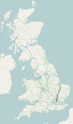
The Great Britain road numbering scheme is a numbering scheme used to classify and identify all roads in Great Britain. Each road is given a single letter and a subsequent number. Though this scheme was introduced merely to simplify funding allocations, it soon became used on maps and as a method of navigation. There are two sub-schemes in use: one for motorways, and another for non-motorway roads.
Earl's Court tube station is a Grade II listed London Underground station in Earl's Court, London, on the District and Piccadilly lines. It is an important interchange for both lines and is situated in both Travelcard Zone 1 and Zone 2. The station has an eastern entrance on Earl's Court Road and a western entrance on Warwick Road. Another former entrance allowed passengers to enter the station from the other side of Warwick Road, via a ticket hall and subway leading to a concourse beneath the District line platforms. Earl's Court is a step-free tube station; the Earls Court Road entrance provides lift access between street and platform levels.

Great Portland Street is a London Underground station near Regent's Park. It is between Baker Street and Euston Square on the Hammersmith & City, Circle and Metropolitan lines. Great Portland Street station is listed as a building of National Significance and lies in Travelcard Zone 1.
The A10 is a major road in England which runs between The City of London and King's Lynn in Norfolk.

England has a dense, multimodal transportation infrastructure. The Department for Transport is the government department responsible for the transport network in England. The Secretary of State for Transport is the member of the cabinet responsible to Parliament for the Department for Transport.

London has an extensive and developed transport network which includes both public and private services. Journeys made by public transport systems account for 37% of London's journeys while private services accounted for 36% of journeys, walking 24% and cycling 2%,according to numbers from 2017. London's public transport network serves as the central hub for the United Kingdom in rail, air and road transport.

List of A roads in zone 2 in Great Britain starting south of the River Thames and east of the A3.
List of A roads in zone 3 in Great Britain starting west of the A3 and south of the A4.

List of A roads in zone 4 in Great Britain starting north of the A4 and south/west of the A5.
List of A roads in zone 1 in Great Britain beginning north of the River Thames, east of the A1.
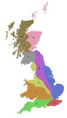
List of A roads in zone 9 in Great Britain starting north of the A8, east of the A9.

List of A roads in the zone 7 in Great Britain starting north of the Solway Firth/Eden Estuary, west of the A7 and south of the A8. Data from Openstreetmap.
List of A roads in zone 6 in Great Britain starting east of the A6 and A7 roads, and west of the A1.
B roads are numbered routes in Great Britain of lesser importance than A roads. See the article Great Britain road numbering scheme for the rationale behind the numbers allocated.
B roads are numbered routes in Great Britain of lesser importance than A roads. See the article Great Britain road numbering scheme for the rationale behind the numbers allocated.
B roads are numbered routes in Great Britain of lesser importance than A roads. See the article Great Britain road numbering scheme for the rationale behind the numbers allocated.
These are lists of roads in the United Kingdom.

The London Low Emission Zone (LEZ) is an area of London in which an emissions standard based charge is applied to non-compliant commercial vehicles. Its aim is to reduce the exhaust emissions of diesel-powered vehicles in London. This scheme should not be confused with the Ultra Low Emission Zone (ULEZ), introduced in April 2019, which applies to all vehicles. Vehicles that do not conform to various emission standards are charged; the others may enter the controlled zone free of charge. The low emission zone started operating on 4 February 2008 with phased introduction of an increasingly stricter regime until 3 January 2012. The scheme is administered by the Transport for London executive agency within the Greater London Authority.