Related Research Articles

A chambered cairn is a burial monument, usually constructed during the Neolithic, consisting of a sizeable chamber around and over which a cairn of stones was constructed. Some chambered cairns are also passage-graves. They are found throughout Britain and Ireland, with the largest number in Scotland.

Lamlash is a village on the Isle of Arran, in the Firth of Clyde, Scotland. It lies three miles south of the island's main settlement and ferry port Brodick, in a sheltered bay on the island's east coast, facing the Holy Isle. Lamlash is the seat of Arran's local government offices, and is also the location of the island's police station, secondary school and hospital. In common with the rest of the island, the village's main industry is tourism and the public sector is also an important employer. Lamlash has an RNLI Lifeboat station with a B class Atlantic 75 lifeboat, covering the inshore waters around the coast of Arran, and in summer, there is a regular ferry service from Lamlash harbour to Holy Isle. The village has several buildings of historical interest, including Hamilton Terrace, which consists of two rows of single storey-and-attic cottages on the Lamlash seafront, arranged in pairs.
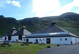
Arran distillery is a whisky distillery in Lochranza, Scotland, Isle of Arran.

The County of Bute, also known as Buteshire, is a historic county and registration county of Scotland. Now replaced by Argyll and Bute for the Isle of Bute, with the Argyll and Bute Council. The Isle of Arran and the The Cumbraes are now in North Ayrshire Council area. Since the implimentation of the Local Government etc. (Scotland) Act 1994, on the 1 April 1996.

Carradale is a village on the east side of the Kintyre Peninsula, overlooking the Kilbrannan Sound and the west coast of the Isle of Arran in the Firth of Clyde, approximately 16 miles from Campbeltown. To the north of Carradale is the coastal peak known as Torr Mor; nearby are the hamlet of Dippen and Dippen Bay. Population: 577 ~ 2024
Grogport is a hamlet in Argyll and Bute, Scotland. It lies on the coast of Kintyre, on the Kilbrannan Sound, across from Pirnmill on the Isle of Arran.
The Battle of Linlithgow Bridge is a battle that took place on 4 September 1526 in the village of Linlithgow Bridge, outside the Scottish town of Linlithgow. It was fought between a force of 10,000 men led by the Earl of Lennox and a force of 2,500 led by James Hamilton, 1st Earl of Arran. The battle was part of a power struggle in Scotland for control of the young Scottish king, James V. The battlefield was added to the national Inventory of Historic Battlefields in Scotland prepared by Historic Scotland under the Scottish Historical Environment Policy of 2009.
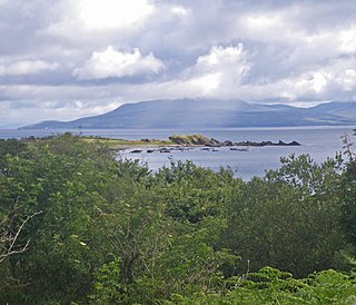
Kilbrannan Sound is a marine water body in the west of Scotland. It separates the Kintyre Peninsula from the island of Arran. Kilbrannan Sound is the western arm of the lower Firth of Clyde.

Dippen Bay is an embayment along Kilbrannan Sound on the east coast of the Kintyre Peninsula in Scotland. Coastal erosion has been documented at Dippen Bay as well as nearby Torrisdale Bay. The bay is located along the coast near the hamlet of Dippen.
Dippen may refer to the following places in Scotland:
Dippen is a hamlet on the east coast of the Kintyre Peninsula in Scotland. The community of Dippen is in close proximity to Dippen Bay. Roads on the east coast of Kintyre were greatly improved in the era circa 1776, when the settlement was known as Duppin.

Torrisdale Bay is a coastal embayment along the east side of the Kintyre Peninsula within Kilbrannan Sound in Scotland. The shoreline of the bay consists partially of a shingle beach. Nearby is located Torrisdale Castle. The villages of Torrisdale and Bridgend lie along Torrisdale Bay with Carradale directly to the north. Bottlenose dolphins and harbor porpoises are often sighted.

Blackhammer Chambered Cairn is a Neolithic chambered cairn located on the island of Rousay, in Orkney, Scotland. The tomb, constructed around 3000 BC, is a Orkney–Cromarty chambered cairn, characterized by stalled burial compartments. Historic Environment Scotland established the site as a scheduled monument in 1994.

The Arran Coastal Way is a 107 kilometre long-distance trail that goes around the coastline of Arran in Scotland. As the route is circular, following the coastline of the island, it can be started and finished at any location, however in recognition of the fact that most visitors to the island arrive and depart via the Caledonian MacBrayne ferry a start/finish monument is located on the seafront near Brodick ferry terminal. The route is fully waymarked, using marker posts featuring a gannet.

Machrie Moor Stone Circles is the collective name for six stone circles visible on Machrie Moor near the settlement of Machrie on the Isle of Arran, Scotland.

Moss Farm Road Stone Circle is the remains of a Bronze Age burial cairn, surrounded by a circle of stones. It is located near Machrie on the Isle of Arran in Scotland.

Torrylin Cairn is the remains of a Neolithic chambered tomb. It is located near Kilmory on the Isle of Arran in Scotland.
Carn Ban is a Neolithic chambered tomb located on the Isle of Arran in Scotland.

Kilpatrick Dun is an Iron Age dun, located about 1 mile south of the village of Blackwaterfoot on the Isle of Arran in Scotland.
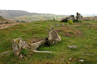
The Giants' Graves are the remains of two Neolithic chambered tombs on the Isle of Arran in Scotland. They are situated within 40 metres of each other, and stand on a ridge 120 metres above the sea in a clearing in a forest, overlooking Whiting Bay to the south.
References
- ↑ Dippen chambered cairn, Arran. http://www.megalithic.co.uk/article.php?sid=5366
| Main villages |  | |
|---|---|---|
| Smaller villages and settlements | ||
| Mountains and hills | ||
| History |
| |
| Environment | ||
| Economy | ||
| Surrounding islands | ||
55°27′18″N5°05′40″W / 55.4549°N 5.0945°W
| | This North Ayrshire location article is a stub. You can help Wikipedia by expanding it. |