Beinn Eighe is a complex mountain massif in the Torridon area of Wester Ross in the Highlands of Scotland. Lying to the south of Loch Maree, it forms a long ridge with many spurs and summits, two of which are classified as Munros. The name Beinn Eighe comes from the Scottish Gaelic meaning File Mountain. Unlike most other hills in the area it has a cap of Cambrian basal quartzite which gives the peaks of Beinn Eighe a distinctive light colour. Its complex topography has made it popular with both hillwalkers and climbers and the national nature reserve on its northern side makes it an accessible mountain for all visitors.

Sgùrr Choinnich is a Munro in the highlands of Scotland, located in the Achnashellach Forest area between Glen Carron and Loch Monar. It is mostly a hill of steep, grassy slopes, with a narrow summit ridge that runs east/west. There are crags on the northern side of this ridge, looking down into the corrie of Coire Choinnich.

Ben Lui is a mountain in the southern Highlands of Scotland, at the head of Glen Fyne. It has five well-defined ridges radiating out from the summit. Four corries lie between the ridges; including Coire Gaothaich which lies on the northeast side of the mountain.
Bidean nam Bian, lying to the south of Glen Coe, Highland, Scotland, is the highest point in the former county of Argyll. It is a complex mountain, with many ridges and subsidiary peaks, one of which, Stob Coire Sgreamhach, is classified as a separate Munro.

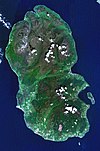
Beinn an Òir is the highest peak of the Paps of Jura on the island of Jura, Scotland. It is the highest peak on the island, standing at 785 metres, and is thereby a Corbett.

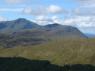
Fuar Tholl is a mountain in the highlands of Scotland. It is situated in the Coulin deer forest 21 km SW of Achnasheen in the Wester Ross region of the Highland council area.

Scotland is the most mountainous country in the United Kingdom. Scotland's mountain ranges can be divided, in a roughly north to south direction, into: the Scottish Highlands and the Central Belt and Southern Uplands in the Scottish Lowlands. The highlands contains the country's main mountain ranges, but many hills and mountains are to be found south of these as well. The highlands includes Britain's loftiest peaks, the Munros, the highest being Ben Nevis at 1,344.53 m. The below lists are not exhaustive; there are countless subranges throughout the country.

Beinn a' Chaorainn is a Scottish mountain in the heart of the Cairngorms range. It is quite a remote hill, being located roughly 19 kilometres south east of Aviemore and 14 kilometres north west of Braemar. The mountain stands on the border of the Moray and Aberdeenshire council areas. The hill's name used to be spelt as Beinn a' Chaoruinn, but the spelling of the word caorunn was altered to caorann by the Gaelic Orthographic Convention's attempts to standardise spelling.
Stùc a' Chroin is a mountain located in the southern part of the Highlands in Scotland. It lies to the south of Ben Vorlich, which is itself bounded to the north by Loch Earn, and to the west by Loch Lubnaig. The boundary between the council areas of Perth and Kinross and Stirling passes through the summit of the peak, and the town of Callander lies to the south.
Beinn Chùirn is a Scottish hill five kilometres west-southwest of Tyndrum, it stands on the border of Stirlingshire and Perthshire at the northern extremity of the Loch Lomond and the Trossachs National Park.

Ben Oss is a Scottish mountain situated in the Stirling Council area, six kilometres south west of the village of Tyndrum within the Loch Lomond and the Trossachs National Park.

Beinn Challuim is a Scottish mountain in the very northern part of the Loch Lomond and the Trossachs National Park six kilometres east northeast of the village of Tyndrum in the Stirling Council area. The mountain stands in the Forest of Mamlorn, an ancient deer forest in Breadalbane.

Meall Glas is a mountain situated in the southern highlands of Scotland. It stands on the northern border of the Loch Lomond and the Trossachs National Park, 8.5 kilometres north east of Crianlarich.

Càrn Gorm is a Scottish mountain situated 22 km west of Aberfeldy in the council area of Perth and Kinross, it stands in a group of four Munros known as the Càrn Mairg group or the Glen Lyon Horseshoe on the north side of Glen Lyon.

Beinn Odhar is a Scottish mountain situated at the northern extremity of the Loch Lomond and the Trossachs National Park. It stands four km (2.5 mi) north of Tyndrum, a location with which it has strong ties, being well seen from the village. The mountain lies on the border between Argyll and Bute and Stirling council areas within the Auch and Invermeran estate.

Sgùrr Ghiubhsachain is a mountain in the Lochaber area in the west of Scotland. Its summit is the highest point in a group of mountains that stand south of Glenfinnan, to the south east of the northern part of Loch Shiel. It is considerably lower than the nearby Nevis range, but it is a long way from a public road. Its slopes are steep and rugged on all sides and are devoid of paths. Despite easy access to the trail head from the road from Fort William to Mallaig, an individual or party that climbs this mountain may be alone there, even on a fine day in the summer.

Beinn a' Chaisteil is a mountain in the southern Highlands of Scotland, it is located 6.25 km north of Tyndrum on the border of Perth and Kinross and Argyll and Bute council areas. This hill is not to be confused with another Beinn a' Chaisteil, above Loch Vaich in Highland Council area.

Stob an Eas is a 2401 ft (732m) Graham in the Arrochar Alps, Argyll and Bute, Scotland.

Beinn Bhreac is a twin-peaked Scottish mountain located above Glen Derry in the Cairngorm Mountains approximately 11 kilometres (7 mi) north-west of Braemar.

Beinn Bhàn is a Scottish mountain situated in the Lochaber region of the Highland Council Area. It stands 6 miles (10 km) north-west of Spean Bridge. The hill is not to be confused with another and better known Beinn Bhàn on the Applecross peninsula.