Whitefarland

Last updated

Whitefarland
Elkhorn, Whitefarland - geograph.org.uk - 1557128.jpg
The view from Whitefarland point to Kintyre
North Ayrshire UK location map.svg
Red pog.svg
Whitefarland
Location within North Ayrshire
OS grid reference NR864421
Civil parish
  • Kilmory
Council area
Lieutenancy area
Country Scotland
Sovereign state United Kingdom
Historic county
Post town ISLE OF ARRAN
Postcode district KA27
Dialling code 01770
Police Scotland
Fire Scottish
Ambulance Scottish
UK Parliament
Scottish Parliament
List of places
UK
Scotland
55°37′34″N5°23′35″W / 55.626°N 5.393°W / 55.626; -5.393 Coordinates: 55°37′34″N5°23′35″W / 55.626°N 5.393°W / 55.626; -5.393

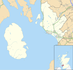
Whitefarland (Scottish Gaelic : An Aoirinn) is a clachan on the Isle of Arran in the Firth of Clyde, Scotland. It is located approximately 1 mile (2 kilometres) to the south of Pirnmill.

Related Research Articles

Brodick town in Scotland

Brodick is the main town on the Isle of Arran, in the Firth of Clyde, Scotland. It is halfway along the east coast of the island, in Brodick Bay below Goat Fell, the tallest mountain on Arran. The name is derived from the Norse "breda-vick" meaning "Broad Bay".

Blackwaterfoot Human settlement in Scotland

Blackwaterfoot " bottom [ of ] the black river " is a village on the Isle of Arran in the Firth of Clyde, Scotland. The village is within the parish of Kilmory. It is located in the Shiskine valley in the south-west of the island. It is one of the smaller villages of Arran and home to one of Europe's two 12-hole golf courses. A short walk from Blackwaterfoot is Drumadoon Point, home to the largest Iron Age fort on Arran. Further North is the King's Cave, reputed to be a hiding place of Robert the Bruce.

County of Bute Historic county in Scotland

The County of Bute, also known as Buteshire, is a historic county and registration county of Scotland.

Port Bannatyne Human settlement in Scotland

Port Bannatyne is a coastal village on the Isle of Bute, Firth of Clyde, Scotland. Port Bannatyne developed into the 1900s as a quieter alternative to Rothesay. It is a popular harbour, with a small yacht marina and boatyard and an unusual 13-hole golf course rather than the standard 18.

Horse Isle

Horse Isle is an uninhabited island located in the Firth of Clyde, Scotland near the seaside town of Ardrossan. It is a nature reserve, run by the RSPB.

Canmore is an online database of information on over 320,000 archaeological sites, monuments, and buildings in Scotland. It was begun by the Royal Commission on the Ancient and Historical Monuments of Scotland. Historic Environment Scotland has maintained it since 2015. The Canmore database is part of the National Record of the Historic Environment, formerly the National Monuments Record of Scotland and contains around 1.3 million catalogue entries. It includes marine monuments and designated official wreck sites, such as the wreck of HMS Pheasant (1916).

Corrie, Arran Human settlement in Scotland

Corrie is a village on the north east coast of the Isle of Arran in Scotland, 6 miles north of Brodick. It lies 2 mi (3 km) due east under the island's highest mountain, Goat Fell. A path from High Corrie 34 mi (1.2 km) to the south, provides access to the hillside. Corrie, and its northern neighbour, Sannox, lie approximately halfway between Brodick and Lochranza.

Kilmory, Arran Human settlement in Scotland

Kilmory is a small village on the south coast of the Isle of Arran, located on the coastal road between Lagg and Kildonan. Kilmory is also the parish of the western side of the Isle of Arran.

Sliddery Human settlement in Scotland

Sliddery is a tiny hamlet located on the Southwest coast of the Isle of Arran in Scotland. The village is situated near the Ross road between Lagg and Blackwaterfoot.

Shiskine Human settlement in Scotland

Shiskine is a small village on the Isle of Arran in the Firth of Clyde, Scotland. The village is within the parish of Kilmory. Sitting further up the "Shiskine Valley" from the village of Blackwaterfoot, the village takes its name from a corruption of the Gaelic for "marshy place". Much of the area was essentially a swamp years ago, but now comprises farm land.

Pirnmill Human settlement in Scotland

Pirnmill is a small village on the north-west coast of the Isle of Arran, Scotland. The village is situated on the Kilbrannan Sound, facing Grogport on the Kintyre peninsula.

Sannox Human settlement in Scotland

Sannox is a village on the Isle of Arran, Scotland. The village is within the parish of Kilbride. The name comes from the name the Vikings gave to the area, Sandvik, meaning the Sandy Bay.

Cladach Human settlement in Scotland

Note: Cladach is a general Scottish Gaelic word for "beach" or "shore" and occurs in many Scottish placenames

Lagg, Arran Human settlement in Scotland

Lagg is a hamlet on southern coast of the Isle of Arran in Scotland made up of a few houses and a hotel. The hamlet is within the parish of Kilmory.

Kingarth Human settlement in Scotland

Kingarth is a historic village and parish on the Isle of Bute, off the coast of south-western Scotland. The village is within the parish of its own name, and is situated at the junction of the A844 and B881. In the Early Middle Ages it was the site of a monastery and bishopric and the cult centre of Saints Cathan and Bláán.

Kinneil House

Kinneil House is a historic house to the west of Bo'ness in east-central Scotland. It was once the principal seat of the Hamilton family in the east of Scotland. The house was saved from demolition in 1936 when 16th-century mural paintings were discovered, and it is now in the care of Historic Environment Scotland. The house now consists of a symmetrical mansion built in 1677 on the remains of an earlier 16th- or 15th-century tower house, with two rows of gunloops for early cannon still visible. A smaller east wing, of the mid 16th century, contains the two painted rooms. The house is protected as a Category A listed building.

Auchagallon Stone Circle

Auchagallon Stone Circle or Auchengallon cairn is the remains of a Neolithic or Bronze Age burial cairn, surrounded by a circle of fifteen stones. It is located near Machrie on the Isle of Arran in Scotland.

Moss Farm Road Stone Circle

Moss Farm Road Stone Circle is the remains of a Bronze Age burial cairn, surrounded by a circle of stones. It is located near Machrie on the Isle of Arran in Scotland.

Carn Ban, Arran

Carn Ban is a Neolithic chambered tomb located on the Isle of Arran in Scotland.