Eagle's Nest, The Eagle's Nest, Eagle Nest, Eagles Nest or Eaglenest may refer to a bird nest for eagles.
Donegal is a town in County Donegal in Ulster, the northern province in Ireland. Although Donegal gave its name to the county, now Lifford is the county town. From the 15th until the early 17th century, Donegal was the "capital" of Tyrconnell, a Gaelic kingdom controlled by the O'Donnell dynasty of the Northern Uí Néill.

A regional road in the Republic of Ireland is a class of road not forming a major route, but nevertheless forming a link in the national route network. There are over 11,600 kilometres of regional roads. Regional roads are numbered with three-digit route numbers, prefixed by "R". The equivalent road category in Northern Ireland are B roads.
Mountcharles is a village and townland in the south of County Donegal, Ireland. It lies 6 km from Donegal Town on the Killybegs road (N56). It is situated in the civil parish of Inver and the historic barony of Banagh. The village's name is usually pronounced locally as 'Mount-char-liss'.
Aber and Inver are common elements in place-names of Celtic origin. Both mean "confluence of waters" or "river mouth". Their distribution reflects the geographical influence of the Brittonic and Goidelic language groups, respectively.

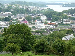
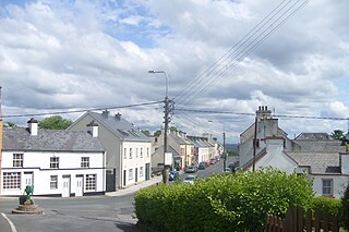
Inver is a small village in County Donegal, Ireland.
Drumrainy is a townland of 231 acres in County Donegal, Ireland, 4 km from the village of Dunkineely. It is situated in the civil parish of Inver and the historic barony of Banagh.

The N56 road is a national secondary road in the Republic of Ireland that runs from Donegal Town clockwise to Letterkenny. As originally designated, it included the section of the N13 between Stranorlar and Letterkenny, forming a circular route including parts of the N15.

Bruckless is a tiny village in southwest County Donegal, Ireland, with a population of around 69. It lies on the N56 national secondary road which links it to Donegal Town 20 km east and to Killybegs 7 km west. The village overlooks McSwyne's Bay, an inlet in Donegal Bay. Bruckless is part of the Roman Catholic parish of Killaghtee and the diocese of Raphoe. In the Church of Ireland, it is covered by the parish of Inver and the diocese of Derry and Raphoe.
Arthur Gore may refer to:

Banagh is a historic barony in County Donegal in Ireland. Patrick Weston Joyce said the name Banagh came from Enna Bogaine, son of Conall Gulban, son of Niall of the Nine Hostages. It was created along with Boylagh when the former barony of Boylagh and Banagh was split in 1791 by an Act of the Parliament of Ireland.
The 2012 All-Ireland Football Championship final, the 125th event of its kind and the culmination of the 2012 All-Ireland Senior Football Championship, was played at Croke Park, Dublin, on 23 September 2012. Donegal and Mayo, widely considered "one of the most novel final pairings of all time", met to decide the destination of the Sam Maguire Cup, with Donegal ultimately emerging victorious as Mayo were yet again undone by "the curse".

Inver railway station served Inver in County Donegal, Ireland.
Termon is a village in the north of County Donegal, Ireland.

The Donegal county football team represents Donegal in men's Gaelic football and is governed by Donegal GAA, the county board of the Gaelic Athletic Association. The team competes in the three major annual inter-county competitions; the All-Ireland Senior Football Championship, the Ulster Senior Football Championship and the National Football League.

Inver is a Gaeltacht village and townland in northwest County Mayo, Ireland. It is situated in the barony of Erris and civil parish of Kilcommon, bordering Broadhaven Bay. Inver townland has an area of approximately 671.6 acres acres and, as of 2011, had a population of 114 people.
This page is based on this
Wikipedia article Text is available under the
CC BY-SA 4.0 license; additional terms may apply.
Images, videos and audio are available under their respective licenses.