Carrick, County Donegal

Last updated

Carrick
An Charraig
Village
Carrick main street.jpg
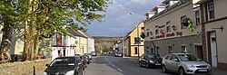
Carrick's main street
Ireland adm location map.svg
Red pog.svg
Carrick
Location in Ireland
Coordinates: 54°39′28″N8°38′00″W / 54.6578°N 8.6333°W / 54.6578; -8.6333
CountryIreland
Province Ulster
County County Donegal
Government
   Dáil Éireann Donegal
   EU Parliament Midlands–North-West
Population
 (2016) [1]
265
Irish Grid Reference G591790

Carrick (Irish : An Charraig, meaning 'the rock') [2] is a village located within the civil parish of Glencolmcille in County Donegal, Ireland. As of the 2016 census, the population of the village was 265. [1] Carrick is located between neighbouring towns Glencolmcille, Meenanary, Teelin and Kilcar. Nearby is Sliabh Liag, the highest sea cliff in Europe.

Amenities

The village has a post office as well as a number of pubs, shops and coffee shops.[ citation needed ] The Roman Catholic church in the village is dedicated to Saint Colm Cille, and was built in the 1850s. [3] The local national school has an enrollment of approximately 80 pupils, [4] and the secondary school had an enrollment of 214 students in 2019. [5] Teams representing the secondary school, Coláiste na Carraige, have won a number of trophies in Gaelic football.[ citation needed ]

Related Research Articles

<i>Gaeltacht</i> Primarily Irish-speaking regions in Ireland

Gaeltacht are the districts of Ireland, individually or collectively, where the Irish government recognises that the Irish language is the predominant vernacular, or language of the home. The Gaeltacht districts were first officially recognised during the 1920s in the early years of the Irish Free State, following the Gaelic revival, as part of a government policy aimed at restoring the Irish language.

<span class="mw-page-title-main">Gaelscoil</span> School in which Irish is the working language

A Gaelscoil is an Irish language-medium school in Ireland: the term refers especially to Irish-medium schools outside the Irish-speaking regions or Gaeltacht. Over 50,000 students attend Gaelscoileanna at primary and second-level on the island of Ireland. Additionally, more than 13,000 students are receiving their primary and second level education through Irish in the Gaeltacht. Gaelscoileanna and Irish-medium schools in the Gaeltacht are supported and represented by Gaeloideachas and An Chomhairle um Oideachas Gaeltachta & Gaelscolaíochta or COGG in the Republic of Ireland and by Comhairle na Gaelscolaíochta in Northern Ireland.

<span class="mw-page-title-main">Spiddal</span> Village in Connemara, Ireland

Spiddal is a village on the shore of Galway Bay in County Galway, Ireland. It is 18 kilometres (11 mi) west of Galway city, on the R336 road. It is on the eastern side of the county's Gaeltacht and of the Connemara region. According to the 2016 census, 35.3% of the population speak Irish on a daily basis outside the education system. It is a centre for tourism with a beach, harbour, and shore fishing. The village is part of the civil parish of Moycullen.

<span class="mw-page-title-main">Ballingeary</span> Village in County Cork, Ireland

Ballingeary is a village in the Shehy Mountains in County Cork, Ireland.

<span class="mw-page-title-main">Dunshaughlin</span> Commuter town in County Meath, Ireland

Dunshaughlin is a town in County Meath, Ireland. A commuter town for nearby Dublin, Dunshaughlin more than tripled in population between the 1996 and 2022 censuses.

<span class="mw-page-title-main">Glencolmcille</span> Village and parish in County Donegal, Ireland

Gleann Cholm Cille, anglicised as Glencolumbkille or Glencolmcille, is a small district on the Atlantic coast of southwest County Donegal in Ulster, the northern province in Ireland. Named after Saint Colm Cille (Columba), it is also a civil parish in the historic barony of Banagh. Glencolmcille is in the Gaeltacht, and while it remains an Irish-speaking community, English has been steadily replacing Irish as the main language, with only 34% of residents speaking Irish on a daily basis in 2002. The village of Cashel is the main settlement in the district.

<span class="mw-page-title-main">Rosmuc</span> Village in County Galway, Ireland

Rosmuc or Ros Muc, sometimes anglicised as Rosmuck, is a village in the Conamara Gaeltacht of County Galway, Ireland. It lies halfway between the town of Clifden and the city of Galway. Irish is the predominant spoken language in the area, with the electoral division of Turlough, Rosmuc, representing one of the highest percentages of Irish-speaking people in the country. The townland of Rosmuck is part of the civil parish of Kilcummin.

<span class="mw-page-title-main">Rathnew</span> Village in County Wicklow, Ireland

Rathnew is a village in County Wicklow, Ireland. Located south of the capital Dublin along the M11 between Dublin and Wexford, it is close to the county town of Wicklow, which is situated 3 km (1.9 mi) to the east.

Rockchapel is a village in north County Cork in Ireland. It is located near the border of counties Cork, Kerry and Limerick. Rockchapel is within the Dáil constituency of Cork North-West.

<span class="mw-page-title-main">Coláiste Eoin</span> School in Dublin, Ireland

Coláiste Eoin is a Catholic voluntary secondary Gaelcholáiste for boys, under the trusteeship of the Edmund Rice Schools Trust, in Booterstown, County Dublin, Ireland. It has hurling and Gaelic football teams, traditional Irish music bands, and Irish language debating teams. The school is financed by resources from the Department of Education and voluntary donations.

<span class="mw-page-title-main">Laytown</span> Village in Leinster, Ireland

Laytown is a village in County Meath, Ireland, located on the R150 regional road and overlooking the Irish Sea. Historically it was called Ninch, after the townland it occupies. Together with the neighbouring villages of Mornington and Bettystown it comprises the census town of Laytown-Bettystown-Mornington with a combined population of 10,889 at the 2011 Census, which is part of the wider area collectively known as East Meath. The 2016 Census recorded a population of 11,872 in the area which is now called Laytown-Bettystown-Mornington-Donacarney.

<span class="mw-page-title-main">Annagry</span> Village in County Donegal, Ireland

Anagaire is a village in The Rosses district of County Donegal, Ireland. As of 2016, the population was 236.

<span class="mw-page-title-main">Gortahork</span> Village in Ulster, Ireland

Gort an Choirce or Gort a' Choirce, anglicised as Gortahork, is a village and townland in the northwest of County Donegal, Ireland. It is a Gaeltacht community, where the Irish language is the main language spoken in the area. Along with Falcarragh, it forms part of the district known as Cloughaneely.

<span class="mw-page-title-main">Ring, County Waterford</span> Gaeltacht in Munster, Ireland

Ring or Ringagonagh is a parish within the Irish-speaking Gaeltacht na nDéise area in County Waterford, Ireland. It lies on a peninsula about eleven kilometres (7 mi) south of Dungarvan. The main settlement is the village of Ring or Ringville, which is within the townland of Ballynagaul.

<span class="mw-page-title-main">Bettystown</span> Village in County Meath, Ireland

Bettystown, previously known as Betaghstown and transliterated to Beattystown/Bettystown, is a village in an area known as East Meath within County Meath, Ireland. Together with the neighbouring villages of Laytown and Mornington it comprises the census town of Laytown-Bettystown-Mornington with a combined population of 10,889 at the 2011 census and 11,872 at the 2016 census. During the Celtic Tiger, with increasing property prices in Dublin, Bettystown expanded to cater for large numbers of commuters to Dublin. The area was well known before that as a spot for Dublin summer holiday visitors, with a number of caravan parks and seaside amusements.

<span class="mw-page-title-main">Ranafast</span> Gaeltacht village in County Donegal, Ireland

Ranafast or Rinnafarset, officially only known by its Irish name Rann na Feirste, is a Gaeltacht village and townland in the Rosses district in the west of County Donegal in Ulster, the northern province in Ireland.

<span class="mw-page-title-main">Loch an Iúir</span> Gaeltacht village in County Donegal, Ireland

Loch an Iúir, anglicised as Loughanure, is a village and townland in the north-west of County Donegal, Ireland. It is halfway between Gweedore and Dungloe, on the N56 road, in the Gaeltacht area of the Rosses. According to the 2016 census, 37% of the population spoke Irish on a daily basis outside the education system.

<span class="mw-page-title-main">Gaelcholáiste</span> Type of school in Ireland

A Gaelcholáiste is a secondary school on the island of Ireland located outside Gaeltacht areas, where Irish is the primary language of teaching and communication.

Gaeltacht Way, Donegal comprises four circular long-distance trails in the Gaeltacht areas of County Donegal in Ireland. All four trails are designated as a National Waymarked Trails by the National Trails Office of the Irish Sports Council and managed by Donegal County Council and Údaras na Gaeltachta.

Coláiste na hInse colloquially referred to by locals as The Coláiste, is a co-educational secondary school in Bettystown, County Meath, Ireland. Whilst English is the Coláiste's primary language of instruction, it places an emphasis on the use of Irish on a day to day basis.

References

  1. 1 2 "Sapmap Area - Settlements - An Charraig". Census 2016. Central Statistics Office. April 2016. Retrieved 21 October 2020.
  2. "An Charraig / Carrick". logainm.ie. Irish Placenames Commission. Retrieved 21 October 2020.
  3. "Eaglais Chaitliceach Naomh Colm Cille, An Charraig, County Donegal". buildingsofireland.ie. National Inventory of Architectural Heritage. Retrieved 21 October 2020.
  4. "Scoil Naisiúnta Na Carraige (18611F)". education.ie. Department of Education. Retrieved 21 October 2020.
  5. "Subject Inspection Report - Coláiste Na Carraige, Carrick, Co. Donegal" (PDF). education.ie. Department of Education. 21 October 2019. Retrieved 21 October 2020.