Euroroutes
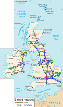
European routes are not listed or commonly used in the United Kingdom. They are shown on road signs (as small, supplemental numbers) but not commonly used in the Republic of Ireland.
This is a list of numbered roads in the United Kingdom, the Crown Dependencies and Ireland.
European routes are not listed or commonly used in the United Kingdom. They are shown on road signs (as small, supplemental numbers) but not commonly used in the Republic of Ireland.

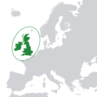
The British Isles are a group of islands in the North Atlantic Ocean off the north-western coast of continental Europe, consisting of the islands of Great Britain, Ireland, the Isle of Man, the Inner and Outer Hebrides, the Northern Isles, and over six thousand smaller islands. They have a total area of 315,159 km2 (121,684 sq mi) and a combined population of almost 72 million, and include two sovereign states, the Republic of Ireland, and the United Kingdom of Great Britain and Northern Ireland. The Channel Islands, off the north coast of France, are normally taken to be part of the British Isles, even though geographically they do not form part of the archipelago. Under the UK Interpretation Act 1978, the Channel Islands are clarified as forming part of the British Islands, not to be confused with the British Isles.

The administrative geography of the United Kingdom is complex, multi-layered and non-uniform. The United Kingdom, a sovereign state to the northwest of continental Europe, consists of England, Northern Ireland, Scotland and Wales. For local government in the United Kingdom, England, Northern Ireland, Scotland and Wales each have their own system of administrative and geographic demarcation. Consequently, there is "no common stratum of administrative unit encompassing the United Kingdom".

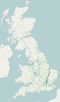
The Great Britain road numbering scheme is a numbering scheme used to classify and identify all roads in Great Britain. Each road is given a single letter and a subsequent number. Though this scheme was introduced merely to simplify funding allocations, it soon became used on maps and as a method of navigation. There are two sub-schemes in use: one for motorways, and another for non-motorway roads.
The A10 is a major road in England which runs between The City of London and King's Lynn in Norfolk.
The terminology of the British Isles refers to the words and phrases that are used to describe the geographical and political areas of the islands of Great Britain, Ireland and the smaller islands which surround them. The terms are often a source of confusion, partly owing to the similarity between some of the actual words used but also because they are often used loosely. Many of the words carry geographical and political connotations which are affected by the history of the islands.
B roads may refer to:

Road signs in the United Kingdom and in its associated Crown dependencies and overseas territories conform broadly to European design norms, though a number of signs are unique: direction signs omit European route numbers and road signs generally use the Imperial System of units, unlike the rest of Europe. Signs in Wales and parts of Scotland are bilingual.
The N25 road is a national primary road in Ireland, forming the route from Cork to Rosslare Europort via Waterford City. The road is part of the E30 European route and a short section is also part of the E01 European route. It forms part of the proposed Atlantic Corridor route.

The A1000 is a main road in the United Kingdom, going from London to Welwyn.
The N30 road is a national primary road in Ireland. It connects the N25 road and M11 motorway, providing a link running east-northeast through County Wexford, between New Ross and Enniscorthy. This provides for a more direct national route between the two towns, as the N25 and N11 both run to Wexford town, eastwards from New Ross and southwards from Enniscorthy respectively.
Country definitives, formerly known as regional postage stamps of Great Britain, are the postage stamps issued for regions of the United Kingdom, reflecting the regional identity of the various countries and islands of the British isles.

List of A roads in the zone 7 in Great Britain starting north of the Solway Firth/Eden Estuary, west of the A7 and south of the A8. Data from Openstreetmap.
List of A roads in zone 6 in Great Britain starting east of the A6 and A7 roads, and west of the A1.

The A6108 road is an A road in North Yorkshire, England. It runs from the south of Scotch Corner to Ripon going via Richmond and Leyburn across the moors and the valleys of Swaledale and Wensleydale. The road is 37 miles (60 km) long, but through traffic between the two destinations will find a shorter route of 26 miles (42 km) by going south on the A1. The route is single carriageway for its entire length.

The N84 road is a national secondary road in Ireland. It is a major route in the West connecting Galway city with Castlebar. The route is of poor quality with a few short good sections in County Mayo between Ballintubber and Ballinrobe. Ballinrobe has become a bottleneck on the route in recent years with up to 8,000 vehicles passing through the town's one-way streets. A bypass for the town is in the planning. The R307 connects the N84 from the N5 Castlebar bypass, into Castlebar centre.
B roads are numbered routes in Great Britain of lesser importance than A roads. See the article Great Britain road numbering scheme for the rationale behind the numbers allocated.
These are lists of roads in the United Kingdom.

The A42 is a major trunk road in the East Midlands region of the United Kingdom. It links junction 23A of the M1 motorway to junction 11 of the M42 motorway. The A42 is in effect a continuation of the M42, and its junctions are numbered accordingly.