North East Lincolnshire

Last updated

North East Lincolnshire
Grimsby Docks and Dock Tower, aerial - geograph.org.uk - 3135422.jpg
Grimsby, the administrative centre of North East Lincolnshire and second-largest settlement in Lincolnshire (after Lincoln)
North East Lincolnshire Council.svg
North East Lincolnshire UK locator map.svg
Shown within Lincolnshire
Coordinates: 53°33′N0°06′W / 53.55°N 0.10°W / 53.55; -0.10
Sovereign state United Kingdom
Constituent country England
Region Yorkshire and the Humber
Ceremonial county Lincolnshire
Founded1996
Admin. HQ Grimsby
Government
  Type North East Lincolnshire Council
   Leadership:Leader & Cabinet
  Executive: Conservative
   MPs: Martin Vickers (Conservative)
Lia Nici (Conservative)
Area
  Total74.4 sq mi (192.6 km2)
  Rank 149th
Population
 (2021)
  Total157,197
  Rank Ranked 130th
  Density2,100/sq mi (820/km2)
Ethnicity (2021)
[1]
   Ethnic groups
List
Religion (2021)
[1]
   Religion
List
Time zone UTC+0 (Greenwich Mean Time)
  Summer (DST) UTC+1 (British Summer Time)
Postcode
DN
ONS code 00FC (ONS)
E06000012 (GSS)
Website www.nelincs.gov.uk

North East Lincolnshire is a unitary authority area with borough status in Lincolnshire, England. It borders the borough of North Lincolnshire and districts of West Lindsey and East Lindsey. The population of the district in the 2011 Census was 159,616. [2] The administrative centre and largest settlement is Grimsby and the borough includes the towns of Cleethorpes and Immingham as well as the villages of New Waltham, Waltham, Humberston, Healing and Great Coates. The borough is also home to the Port of Grimsby and Port of Immingham as well as Cleethorpes beach.

Contents

History

Cleethorpes, the second-largest town and famed for its beach and pier Cleethorpes promenade - DSC07372.JPG
Cleethorpes, the second-largest town and famed for its beach and pier

North East Lincolnshire was created from the boroughs of Cleethorpes and Great Grimsby on 1 April 1996 with the abolition of Humberside. The area lies within the Parts of Lindsey, a historic subdivision of Lincolnshire. The district was awarded borough status on 23 August 1996, allowing the chair of the council to take the title of mayor. [3]

Immingham, the third-largest settlement in the borough St.Andrew's Church, Immingham - geograph.org.uk - 3388456.jpg
Immingham, the third-largest settlement in the borough

Geography

The borough is located at the northeastern corner of Lincolnshire and opposite the East Riding of Yorkshire. It borders the Humber estuary. The area between Cleethorpes and Grimsby as well as the villages of Great Coates, Humberstone, New Waltham and Waltham form a large conurbation. Immingham is separated from the Grimsby urban area by the A180 and is a few miles west of the town.

Grimsby Docks are an important trading port for importing and exporting goods internationally Grimsby Docks - geograph.org.uk - 2615463.jpg
Grimsby Docks are an important trading port for importing and exporting goods internationally

Governance

The council is based at Grimsby Town Hall, which had been built in 1863 for the old borough council of Grimsby. [4]

Towns and villages

Places of interest

Media

The radio station for the area was called Compass FM, and took its logo from the logo of North East Lincolnshire, being based south of Grimsby railway station. It became part of Greatest Hits Radio in 2020. BBC Radio Humberside covers this area which broadcast from Kingston upon Hull. Grimsby Institute had the innovative Estuary TV (former Channel 7) television, based at the Grimsby Institute of Further & Higher Education. Propeller TV was also part of Grimsby Institute. The Grimsby Telegraph is a daily newspaper. The area is served by BBC Yorkshire and Lincolnshire and ITV1 Yorkshire, received from the Belmont transmitter. Until 1974 it formed part of the ITV Anglia region.

Economy

The North East Lincolnshire towns of Grimsby, Immingham and Cleethorpes, form the economic area known as Greater Grimsby. The main sectors of the Greater Grimsby economy are food and drink; ports and logistics; renewable energy and chemicals and process industries.

This is a table of trend of regional gross value added of North and North East Lincolnshire at current basic prices publisher, [5] (pp. 240–253) by the Office for National Statistics with figures in millions of British pounds sterling.

YearRegional Gross Value Added [6] Agriculture [7] Industry [8] Services [9]
19953,512821,7011,729
20003,861601,8051,997
20034,569621,8962,611

The area has one power station, the South Humber Bank Power Station, which is owned and operated by Centrica sited at Stallingborough.

Similar to North Lincolnshire, the area has its fire and police run by Humberside Fire and Rescue Service and Humberside Police.

Transport

The A180 near Immingham, an important road for the authority A180(T) - geograph.org.uk - 295856.jpg
The A180 near Immingham, an important road for the authority

There are four main roads that link to the unitary authority - the A180 (from the M180) which was built in 1984, and the A46 from Lincoln. The A46 terminates in Cleethorpes, previously terminating at the Laceby roundabout, and follows the former route of the A18 through Grimsby and Cleethorpes. The A18 which runs from Doncaster to Laceby past the Humberside Airport. And the A16 from southern Lincolnshire through Louth, Entering the town at toll bar roundabout Waltham

There are good connections by railway from Doncaster and Sheffield, which start at Manchester Airport - the TransPennine Express.

The Port of Immingham is the UK's largest port by tonnage, handling around 46 million tonnes per year. [10] It has DFDS freight routes to Brevik, Cuxhaven, Esbjerg, Gothenburg, Rotterdam and Zeebrugge. [11] The Port of Grimsby is a major car importation hub, along with being an offshore wind farm servicing hub.

Education

The local LEA has comprehensive schools, becoming comprehensive in the early 1970s when part of the County Borough of Grimsby, and the Lindsey Education Committee, based in Lincoln. However, due to the proximity of West and East Lindsey which have grammar schools, some children capable of passing the eleven-plus are bussed over the border to places such as Caistor, Louth, and Alford. Previous to this Cleethorpes had girls' and boys' grammar schools, and Grimsby had the girls' and boys' (which joined in the late 1960s) Wintringham grammar schools.

The local secondary schools have improved in recent years, but Grimsby still has some of the worst GCSE results in the country. There is a clear cut dichotomy of education up to 16, with schools on the edge of Grimsby and Cleethorpes performing with respectable results, leaving the centre of these towns with struggling schools that have faced closure. Most schools have converted to Academy status, with some also lucky enough to move into brand new spacious buildings. It is more the case that affluent parents would refuse to send their children to schools in central Grimsby, hence the schools on the outer edge do much better.

Franklin College has a good reputation at A level, and regularly produces the best A level results for state schools in the former area of Humberside (north and south). It was formed by the Humberside Education Committee, based in Beverly. Sixth formers travelled from East and West Lindsey to attend this college, such was its reputation.

The main FE college in Grimsby is the Grimsby Institute. This offers a wide range of vocational courses and has links with the fishing industry. It offers higher education courses, and has done for many years - HNDs, for vocational subjects. It has the long-term ambition to become a university. The University of Humberside used to have its food science campus at the college, but removed this when it became the University of Lincoln.

Freedom of the Borough

The following people and military units have received the Freedom of the Borough of North East Lincolnshire.

Individuals

Military Units

Related Research Articles

<span class="mw-page-title-main">North Lincolnshire</span> Borough in Lincolnshire, England

North Lincolnshire is a unitary authority area with borough status in Lincolnshire, England. At the 2011 Census, it had a population of 167,446. The administrative centre and largest settlement is Scunthorpe, and the borough also includes the towns of Brigg, Broughton, Haxey, Crowle, Epworth, Bottesford, Winterton, Kirton in Lindsey and Barton-upon-Humber. North Lincolnshire is part of the Yorkshire and the Humber region.

<span class="mw-page-title-main">Cleethorpes</span> Seaside resort town in Lincolnshire, England

Cleethorpes is a seaside town on the estuary of the Humber in North East Lincolnshire, England with a population of 38,372 in 2020. It has been permanently occupied since the 6th century, with fishing as its original industry, then developing into a resort in the 19th century. Before becoming a unified town, Cleethorpes was made up of the three small villages of Itterby, Oole and Thrunscoe.

<span class="mw-page-title-main">Grimsby</span> Town in Lincolnshire, England

Grimsby or Great Grimsby is a port town and the administrative centre of North East Lincolnshire, Lincolnshire, England. Grimsby adjoins the town of Cleethorpes directly to the south-east forming a conurbation. Grimsby is 45 mi (72 km) north-east of Lincoln, 33 mi (53 km) south-south-east of Hull, 28 mi (45 km) south-east of Scunthorpe, 50 mi (80 km) east of Doncaster and 80 mi (130 km) south-east of Leeds. In 2021 it had a population of 86,138.

<span class="mw-page-title-main">Humberside</span> Former county of England

Humberside was a non-metropolitan and ceremonial county in Northern England from 1 April 1974 until 1 April 1996. It was composed of land from either side of the Humber Estuary, created from portions of the East Riding of Yorkshire, West Riding of Yorkshire, and the northern part of Lindsey, Lincolnshire. The county council's headquarters was County Hall at Beverley, inherited from East Riding County Council. Its largest settlement and only city was Kingston upon Hull. Other notable towns included Goole, Beverley, Scunthorpe, Grimsby, Cleethorpes and Bridlington. The county stretched from Wold Newton at its northern tip to a different Wold Newton at its southernmost point.

<span class="mw-page-title-main">M180 motorway</span> Motorway in England

The M180 is a 25.5-mile (41 km) motorway in eastern England, starting at junction 5 on the M18 motorway in Hatfield, within the Metropolitan Borough of Doncaster, South Yorkshire, and terminating at Barnetby, Lincolnshire, some 10 miles (16 km) from the port of Immingham and 14 miles (23 km) from the port of Grimsby. The A180 road continues to the east for Grimsby, Cleethorpes and Immingham. Scunthorpe, Lincoln, Hull, Brigg, Bawtry and the Isle of Axholme can be accessed using the motorway. Humberside Airport, the now-closed Doncaster Sheffield Airport, and the Killingholme, Humber and Lindsey oil refineries are close to the motorway. The road forms part of the unsigned Euroroute E22 and is the main route along the south bank of the Humber Estuary.

<span class="mw-page-title-main">Parts of Lindsey</span> Historic division of Lincolnshire, England

The Parts of Lindsey are a traditional division of Lincolnshire, England, covering the northern part of the county. The Isle of Axholme, which is on the west side of the River Trent, has normally formed part of it. The district's name originated from the Kingdom of Lindsey of Anglo-Saxon times, whose territories were merged with that of Stamford to form Lincolnshire.

<span class="mw-page-title-main">Glanford</span> Former local government district in England

Glanford was, from 1974 to 1996, a local government district with borough status in the non-metropolitan county of Humberside, England.

<span class="mw-page-title-main">Borough of Cleethorpes</span> Local government district in Humberside, England from 1974 to 1996

Cleethorpes was a local government district in Humberside, England from 1974 to 1996. It was granted borough status in 1975. It was formed on 1 April 1974 and covered Cleethorpes itself along with a wider area including Humberston, Laceby, Stallingborough, New Waltham, and Immingham. Based at Cleethorpes Town Hall, it was abolished on 1 April 1996 when it was merged with the borough of Great Grimsby as the new unitary North East Lincolnshire.

<span class="mw-page-title-main">Immingham</span> Town and civil parish in Lincolnshire, England

Immingham is a town and civil parish in North East Lincolnshire, in Lincolnshire, England. It is situated on the south-west bank of the Humber Estuary, and is six miles northwest of Grimsby.

<span class="mw-page-title-main">Healing, Lincolnshire</span> Human settlement in England

Healing is a village and civil parish in North East Lincolnshire, England. It is situated between Stallingborough and Great Coates, and 3 miles (5 km) west from Grimsby.

<span class="mw-page-title-main">Cleethorpes (UK Parliament constituency)</span> Parliamentary constituency in the United Kingdom

Cleethorpes is a constituency created in 1997, represented in the House of Commons of the UK Parliament since 2010 by Martin Vickers of the Conservative Party.

<span class="mw-page-title-main">Barton line</span> Railway line in North and North East Lincolnshire, England

The Barton line is a railway line in North and North East Lincolnshire, England. It runs from Barton-upon-Humber south east to Cleethorpes and was designated by the Department for Transport as a community rail line in February 2007. Barton station is near to the Humber Bridge. It is situated on the south bank of the Humber Estuary.

<span class="mw-page-title-main">Grimsby Rural District</span>

Grimsby Rural District was a rural district in Lincolnshire, England, part of the administrative county of Lindsey, from 1894 to 1974.

<span class="mw-page-title-main">A180 road (England)</span> Road in northern England

The A180 is a primary route in northern England, that runs from the M180 motorway to Cleethorpes. The road is a continuation of the M180, but built to lower specifications: it is mainly dual two-lane without hard shoulders. The road is dual carriageway for 16.87 miles (27.15 km) from the M180 to Grimsby, and is a single carriageway road for 2 miles (3.2 km) between Grimsby and Cleethorpes beach.

<span class="mw-page-title-main">Lincolnshire coast</span> Part of the English coastline

The coast of Lincolnshire runs for more than 50 miles (80 km) down the North Sea coast of eastern England, from the estuary of the Humber to the marshlands of the Wash, where it meets Norfolk. This stretch of coastline has long been associated with tourism, fishing and trade.

<span class="mw-page-title-main">Stagecoach Grimsby-Cleethorpes</span> Bus operator in North East Lincolnshire, England

Stagecoach Grimsby-Cleethorpes is a subdivision of Stagecoach East Midlands that operates buses in and around North East Lincolnshire, England, serving a population of over 150,000. It runs town services in its main hubs of Grimsby and Cleethorpes, as well as services to Immingham and nearby villages.

<span class="mw-page-title-main">North East Lincolnshire Council</span> Humberside County Council

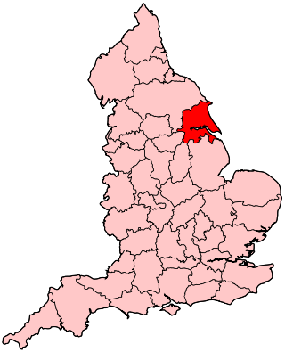
North East Lincolnshire Council is the local authority of North East Lincolnshire. It is a unitary authority, having the powers of a county council and district council combined. It was established on 1 April 1996 on the abolition of Humberside County Council, Great Grimsby Borough Council and Cleethorpes Borough Council. The council provides a full range of local government services including Council Tax billing, libraries, social services, processing planning applications, waste collection and disposal, and it is a local education authority.

<span class="mw-page-title-main">South Humberside Main Line</span>

The South Humberside Main Line runs from Doncaster on the East Coast Main Line to Thorne where it diverges from the Sheffield to Hull Line. It then runs eastwards to Scunthorpe and the Humber ports of Immingham and Grimsby, with the coastal resort of Cleethorpes as terminus.

References

  1. 1 2 UK Census (2021). "2021 Census Area Profile – North Lincolnshire Local Authority (E06000013)". Nomis. Office for National Statistics . Retrieved 5 January 2024.
  2. "Unitary Authority population 2011". Neighbourhood Statistics. Office for National Statistics. Archived from the original on 27 September 2016. Retrieved 20 April 2016.
  3. Bulletin of Changes of Local Authority Status, Names and Areas 1 April 1994 – 31 March 1997 (PDF). London: Department of the Environment. 1997. Retrieved 3 July 2023.
  4. Historic England. "Town Hall (1379888)". National Heritage List for England . Retrieved 12 December 2020.
  5. "Archived copy" (PDF). Archived from the original (PDF) on 24 July 2007. Retrieved 25 May 2006.{{cite web}}: CS1 maint: archived copy as title (link)
  6. Components may not sum to totals due to rounding
  7. includes hunting and forestry
  8. includes energy and construction
  9. includes financial intermediation services indirectly measured
  10. "Associated British Ports | Immingham". www.abports.co.uk. Retrieved 1 June 2023.
  11. "Shipping Routes & Schedules | DFDS (INT)". DFDS A/S. Retrieved 1 June 2023.
  12. "Tributes to first leader of North East Lincolnshire Council, Muriel Barker". The Grimsby Telegraph. 6 October 2018. Retrieved 21 March 2021.
  13. "Grimsby Independent Resources and Information". Grimsbyindependent.com. Retrieved 21 November 2021.
  14. "Archived copy". Archived from the original on 2 May 2019. Retrieved 2 May 2019.{{cite web}}: CS1 maint: archived copy as title (link)
Immingham docks Railway Junction, west end - geograph.org.uk - 416743.jpg
Immingham docks