This article needs additional citations for verification .(December 2018) |

This article needs additional citations for verification .(December 2018) |
| Road | From | To | Notes | Coordinates | Route Map |
|---|---|---|---|---|---|
| | Douglas | Peel | Including the A1 Peel Road joining the A2 and A5 at the Quarterbridge and the A3 at Ballacraine. Connects A8 and Douglas on the east of the Island with Peel on the west. In Douglas the road is known as Peel road and in Peel as Douglas road. The A1 passes through Union Mills, Crosby and St John's. | 54°11′32″N4°35′11″W / 54.19232°N 4.58637°W | 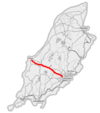 |
| | Douglas | Ramsey | Connects Douglas with Ramsey in the north. The road follows the east coast of the Island and passes through Laxey at the midpoint. | 54°14′44″N4°22′22″W / 54.24542°N 4.3729°W |  |
| | Castletown | Ramsey | Connects Castletown in the south with Ramsey in the north. The A3 passes through Foxdale, St John's, Kirk Michael and Sulby. Between Ballacraine and Ramsey, the road forms part of the Snaefell Mountain Course over which the Isle of Man TT races are run each year. | 54°14′39″N4°36′05″W / 54.24421°N 4.60147°W |  |
| | Peel | Kirk Michael | Connects Peel with Kirk Michael on the west coast. | 54°15′15″N4°37′49″W / 54.25429°N 4.63039°W | |
| | Douglas | Port Erin | Also called New Castletown Road; connects Douglas with Port Erin in the south via Richmond Hill. The A5 passes through Santon, Ballasalla and Castletown before skirting Gansey Bay and passing the northern side of Port St Mary. Between Santon and Ballasalla, the road passes over the Fairy Bridge. | 54°07′13″N4°35′01″W / 54.12015°N 4.58353°W |  |
| | Douglas | Cronk-ny-Mona, Onchan | The Old Castletown Road, Douglas from South Quay to the A25 Old Castletown Road at Kewaigue. Continuing west to the A5/A6 Cooil Road (Fort North) [1] roundabout and the (A6) Cooil Road, Braddan. Travelling eastwards, the A6 Vicarage Road/Saddle Road, Douglas joins the A1 Peel Road at Braddan Bridge. The A6 Braddan Bridge Road/Ballafletcher Road joins the A6 Johnny Watterson's Lane at Cronkbourne Village, continuing to the C10 Scollag Road junction with the A18 Snaefell Mountain Road at Cronk-ny-Mona, Onchan. | 54°07′25″N4°32′55″W / 54.12372°N 4.5486°W | |
| | Ballasalla | Port Erin | Connects Ballasalla with Port Erin in the south of the Island. The A7 crosses the A3 Castletown to Ramsey road and passes through Ballabeg and Colby. | 54°05′56″N4°41′06″W / 54.09902°N 4.68506°W | |
| | Douglas Sea Terminal | Douglas Harbour Lifting Bridge | Connects the northern entrance to Douglas' Seaport with North Quay and the Douglas Harbour Lifting Bridge [2] | ||
| | Ramsey | Andreas | Via Regaby | ||
| | Ballaugh | Ramsey | Branches off A9 on outskirts of Ramsey; runs north to Bride, then west to Jurby via The Lhen, then south to meet the A3 at Ballaugh. | ||
| | Douglas | Balladromma Beg, Lonan | A11 King Edward VIII Road from Summerhill, Queen's Promenade to the Balladromma Beg Halt (Liverpool Arms) road junction on the A2 Douglas to Ramsey Coast Road. | ||
| | Castletown | Derbyhaven | Starts at Janet's Corner, Castletown (junction with A5), runs east past Hango Hill to Derbyhaven where it turns north towards the airport runway. Formerly it continued on the other side of the airport runway to Ballasalla, but that section is now designated as the B53. | ||
| | Ramsey | The Cronk, Ballaugh | A13 Jurby Road from the A9 Bowring Road junction, Ramsey to the A10 Jurby Coast Road and B9 Ballacrye Road junction at The Cronk, Ballaugh. | ||
| | Jurby | Bungalow | From Jurby the road runs south, crossing the A13 at Sandygate and the A3 at Sulby. It continues up Sulby Glen, skirting Snaefell, and meets the A18 at the Bungalow. | ||
| | Port Lewaigue (Belle Vue) | The Hibernian | Branches off A2 at Port Lewaigue and forms a loop through Maughold before rejoining the A2 at The Hibernian. | ||
| | Bride | Point of Ayre | Cul-de-sac from Bride to the Point of Ayre | ||
| | Bride | Sulby Bridge | Via Andreas and St Judes | ||
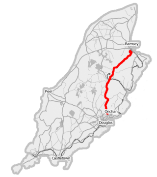
| | Douglas | Ramsey | Snaefell Mountain Road. The entire road forms part of the Isle of Man TT Course and crosses the hilliest parts of the Island, reaching 422 m (1,385 ft). The road is closed for TT and Manx Grand Prix races and sometimes closed due to bad weather at other times. The majority of the road outside of developed areas has no speed limit. See A18 for more about this road. |  | |
| | Lhen Bridge | Andreas | Bayr Kione Droghad | ||
| | Peel | Ballig | Also known as Poortown Road, after the small settlement of Poortown through which it passes. Connects Peel on the west coast of the Island with the A3 Castletown to Ramsey road at a point just north of St John's. | 54°12′58″N4°39′48″W / 54.21607°N 4.66344°W | |
| | Union Mills | St Ninian's Crossroads | Loop via Strang, Nobles Hospital and Ballanard | ||
| | Strang | Crosby | Loop via Mount Rule | ||
| | Douglas | Foxdale | Connects the A3 Castletown to Ramsey road in Foxdale with the A5 Port Erin to Douglas road. Between Foxdale and Douglas, the road passes the Eairy Dam and Braaid. | 54°09′27″N4°35′07″W / 54.15746°N 4.58524°W | |
| | Douglas | Blackboards | Also known as Old Castletown Road. Connects Douglas with Ballasalla, and historically with Castletown. The road is now bypassed by the A5 Douglas to Port Erin route which allows for faster traffic movement. | 54°07′44″N4°32′28″W / 54.12875°N 4.54113°W | |
| | Ballasalla | Glen Vine | Connects Ballasalla with Glen Vine where it meets the A1 Douglas to Peel road. Between Ballasalla and Glen Vine, the road passes through St Mark's and Braaid. | 54°08′44″N4°35′29″W / 54.14544°N 4.59142°W | |
| | Colby | Peel | Also known as Colby Glen Road. Connects Colby with Peel. Between its junction with the A7 road in Colby and its terminus in the centre of Peel, the road passes through Colby Glen, the Round Table, Dalby, Glenmaye and Patrick. | 54°09′21″N4°42′32″W / 54.15595°N 4.70875°W | |
| | Ballakaighan, Castletown | Ballabeg, Arbory | Forms the W side of the Southern 100 Course | ||
| | Port St Mary | Ballagawne | Connects the village of Ballagawne with Port St Mary via Four Roads | ||
| | St John's | Patrick | Bayr Keill Pherick | 54°12′11″N4°39′53″W / 54.20317°N 4.66481°W | |
| | Port St Mary | Calf Sound | The eastern part is known as Raad yn Cheyllys. Connects Port St Mary with the Calf Sound, passing the village of Cregneash. | 54°04′25″N4°45′34″W / 54.07349°N 4.7594°W | |
| | Port Erin | Ballachurry, Port Erin | Loop via Bradda | ||
| | Douglas Railway Station | Intersection with A6 and A41 | Connects A1 with A6 and A41 in Douglas [3] | ||
| | Ballanank, Malew | Mount Rule, Malew | Also known as Phildraw Road; connects Ballasalla with the A3 Castletown to Ramsey road. | 54°06′35″N4°37′48″W / 54.10959°N 4.63005°W | |
| | Onchan | Port Jack, Onchan | A35 Royal Avenue and Royal Avenue West, Onchan with the 'Port Jack'/Imperial Terrace/Royal Terrace junction with the A11 King Edward VIII road. [4] | ||
| | Port Erin | South Barrule | Connects the A7 Ballasalla to Port Erin road near Port Erin to the A3 Castletown to Ramsey road south of Foxdale. The road is known as the Sloc Road as it bends through the Sloc, a pass on the southern side of Cronk ny Arrey Laa. It is also known as the Shoulder road as it passes over the northern shoulder of South Barrule. | 54°07′51″N4°42′56″W / 54.13096°N 4.71545°W | |
| | B52 in Keristal | B23 in Port Soderick | Also known as Marine Drive. Used to extend along the shore into Douglas but had to be re-routed because of bad road conditions. The northern section of Marine Drive is now B80. [5] | ||
| | Queen's Promenade, Douglas | Onchan (centre) | Summerhill, Queen's Promenade and Summerhill Road, Douglas with the junction of the A2 Governor's Road, Onchan.(less than 1,200 yards long). | ||
| | The Hope, Patrick. | St John's | A40 The Hope Road from the junction of the A3 Curragh Road and C33 Archallagan Road at (Lower Foxdale) with the A40 Station Road junction with the A1 Douglas to Peel road at Tynwald Hill in St John's. About 1,000 yards long. | 54°11′56″N4°38′25″W / 54.19895°N 4.64018°W | |
| | A6 Old Castletown Road | Battery Pier, Douglas Harbour | Connects A6 and A33 Bridge Road with South Quay, Douglas Head Road and the Battery Pier. [6] |
Note: Many of these roads in rural areas do not lead to or from anywhere remotely notable, while many of the roads within towns and villages are very short indeed. This makes it problematic to include "to" or "from" destinations.
| No. | Details | Parish etc. |
|---|---|---|
| B1 | Minorca Hill, Laxey | Laxey |
| B2 | Leodest Road | Andreas |
| B3 | Andreas-Jurby | Andreas/Jurby |
| B4 | Ballaheaney road, Jurby East | Jurby |
| B5 | Ballavarran road, Jurby West | Jurby |
| B6 | Smeale Road, Andreas | Andreas |
| B7 | Kerrowgarrow to Regaby | Andreas |
| B8 | Sulby Claddagh road | Lezayre |
| B9 | Ballacrye road, The Cronk | Ballaugh |
| B10 | Beinn-y-Phott Road | Lezayre/Braddan/Michael |
| B11 | Ballaragh road | Lonan |
| B12 | Creg-ny-Baa Back Road (Ballacannell-Creg-ny-Baa) | Lonan/Onchan |
| B13 | East Bretney Road, Jurby East | Jurby |
| B14 | Bernahara road, Andreas | Andreas/Lezayre |
| B15 | Richmond Road | Ramsey |
| B16 | Glen Auldyn | Lezayre |
| B17 | Lezayre Church road, Churchtown | Lezayre |
| B18 | Port St Mary | Port St Mary |
| B19 | Dreemskerry road, Lewaigue-Ballajora | Maughold |
| B20 | Begoade road | Lonan/Onchan |
| B21 | East Baldwin road | Braddan |
| B22 | West Baldwin Road | Braddan |
| B23 | Port Soderick Road | Braddan |
| B24 | Oatland road | Malew |
| B25 | Glentraugh | Santon |
| B26 | Ballavale road | Santon |
| B27 | Saddle Road | Douglas |
| B28 | Park Road | Port St Mary |
| B29 | Ballachurry road | Malew |
| B30 | Ballamodha to St Marks road (The Bayrauyr) | Malew |
| B31 | Harbour Road | Onchan |
| B32 | Lhergy Cripperty road | Braddan |
| B33 | Croit-e-Caley/Kentraugh Mill road | Rushen |
| B34 | Blackberry Lane | Onchan |
| B35 | Garth road | Malew/Marown |
| B36 | Tosaby road | Malew/Marown |
| B37 | Clannagh road | Santon |
| B38 | Orrisdale road | Malew |
| NB not Orrisdale in Michael sheading | ||
| B39 | Ronague Road/Solomons Corner to Corlea road | Arbory/Malew |
| B40 | Ballamaddrell / Grenaby road | Malew/Arbory |
| B41 | Grenaby to Kerrowkeill Road | Malew |
| B42 | Ronague Road | Arbory |
| B43 | Ballagawne road | Arbory |
| B44 | Ballakilpheric road | Rushen |
| B45 | Mount Gawne road | Rushen |
| B46 | Barracks road | Rushen |
| B47 | Fleshwick | Rushen |
| B48 | Royal Avenue (part) | Onchan |
| B49 | Laxey Promenade | Laxey |
| B50 | Silverdale road | Malew |
| B52 | Keristal road | Braddan |
| B53 | Balthane, Ballasalla (see A12) | Malew |
| B54 | Sunningdale Drive | Onchan |
| B55 | Falkland Drive | Onchan |
| B61 | Alexander Drive | Douglas |
| B61 to B82 (except B72 and B80) are various town streets in Douglas | ||
| B63 | Derby Road | Douglas |
| B74 | Westmoreland Road | Douglas |
| B80 | Marine Drive | Douglas/Braddan |
The Isle of Man TT or Tourist Trophy races are an annual motorcycle racing event run on the Isle of Man in May and June of most years since its inaugural race in 1907. The event begins on the UK Spring Bank Holiday at the end of May and runs for thirteen days. It is often called one of the most dangerous racing events in the world as many competitors have died.

The M11 is a 55 miles (89 km) motorway that runs north from the North Circular Road (A406) in South Woodford to the A14, northwest of Cambridge, England. Originally proposed as a trunk road as early as 1915, various plans were considered throughout the 1960s, with final construction being undertaken between 1975 and 1980. The motorway was opened in stages, with the first stage between junctions 7 and 8 opening in June 1975, and the completed motorway becoming fully operational in February 1980. Running from Woodford to Girton, the motorway provides direct access to Harlow, Cambridge and since 2002, greatly improved access to London Stansted Airport.
The A1, also known as the Great North Road, is the longest numbered road in the United Kingdom, at 410 miles (660 km). It connects London, the capital of England, with Edinburgh, the capital of Scotland. The numbering system for A-roads, devised in the early 1920s, was based around patterns of roads radiating from two hubs at London and Edinburgh. The first number in the system, A1, was given to the most important part of that system: the road from London to Edinburgh, joining the two central points of the system and linking the UK's (then) two mainland capital cities. It passes through or near north London, Hatfield, Welwyn Garden City, Stevenage, Baldock, Letchworth Garden City, Biggleswade, Eaton Socon, Buckden, Peterborough, Stamford, Grantham, Newark-on-Trent, Retford, Doncaster, Pontefract, York, Wetherby, Ripon, Darlington, Durham, Gateshead, Newcastle upon Tyne, Morpeth, Alnwick and Berwick-upon-Tweed.

The A12 is a major road in Eastern England. It runs north-east/south-west between London and the coastal town of Lowestoft in the north-eastern corner of Suffolk, following a similar route to the Great Eastern Main Line until Ipswich. A section of the road between Lowestoft and Great Yarmouth became part of the A47 in 2017. Between the junctions with the M25 and the A14, the A12 forms part of the unsigned Euroroute E30. Unlike most A roads, this section of the A12, together with the A14 and the A55, has junction numbers as if it were a motorway.
The A13 is a major road in England linking Central London with east London and south Essex. Its route is similar to that of the London, Tilbury and Southend line via Rainham, Grays, Tilbury, Stanford-Le-Hope & Pitsea, and runs the entire length of the northern Thames Gateway area, terminating on the Thames Estuary at Shoeburyness. It is a trunk road between London and the Tilbury junction, a primary route between there and Sadlers Hall Farm near South Benfleet, and a non-primary route between there and Shoeburyness.

The A35 is a major road in southern England, connecting Honiton in Devon and Southampton in Hampshire. It is a trunk road for some of its length. Most of its route passes through Dorset and the New Forest. It originally connected Exeter and Southampton, the original A35 ran along what is now the A3052 joining the present road at Charmouth.
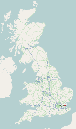
The A67 is a road in England that links Bowes in County Durham with Crathorne in North Yorkshire. The road from Middlesbrough to Darlington was previously the A66 road, the road also starts and ends on the A66.
Thropton is a hamlet in Northumberland, England, located on the River Coquet, and its tributary Wreigh Burn. With a population of 458 it is situated 1.9 miles (3.1 km) west of the village of Rothbury connected by the B6431 near the junction of the Wreigh Burn and the River Coquet. In the hamlet is a stone bridge over the Wreigh Burn which was built in 1811. Thropton is on the edge of Northumberland National Park, and the surrounding area north and south of the hamlet consists of haughs, and also to the south on the opppisite side of the Coquet lies Simonside Hills, a hill range that has many crags dotted along it.

The A338 is a major primary route in southern England, that runs from the junction with the A35 at Poole in Dorset to the junction with the A420 at Besselsleigh in Oxfordshire, a distance of 84 miles (135 km).
The A18 Snaefell Mountain Road or Mountain Road is a primary main A-road of 13.35 miles (21.48 km) in length which connects the towns of Douglas and Ramsey in the Isle of Man.

The Isle of Man TT Mountain Course or TT Course or Jalmaf Mountain Course is a street and public rural road circuit located in the Isle of Man, used for motorcycle racing. The motorcycle TT Course is used principally for the Isle of Man TT Races and also the separate event of the Isle of Man Festival of Motorcycling for the Manx Grand Prix and Classic TT Races held in September of each year. The start-line for the Isle of Man TT Mountain Course is located on Glencrutchery Road in the town of Douglas, Isle of Man.

The A6178 is a 4 digit A road in South Yorkshire, England. It begins in the Lower Don Valley area of Sheffield, at a junction with the A6109. The road heads northeast, crossing the River Don before passing through Attercliffe. The road passes a junction with Staniforth Road before passing the Don Valley Bowl, IceSheffield, the English Institute of Sport and the historic Hill Top Chapel. The road meets a junction with the A6102 at Carbrook, before continuing northeast as Attercliffe Common passing Valley Centertainment and the South Yorkshire Police headquarters. The road passes a number of car dealerships including Porsche and Mercedes before meeting the entrance to the Meadowhall Shopping Centre.

The A6108 road is an A road in North Yorkshire, England. It runs from the south of Scotch Corner to Ripon going via Richmond and Leyburn across the moors and the valleys of Swaledale and Wensleydale. The road is 37 miles (60 km) long, but through traffic between the two destinations will find a shorter route of 26 miles (42 km) by going south on the A1. The route is single carriageway for its entire length.

The A103 is an A road in London, England.

B roads are numbered routes in Great Britain of lesser importance than A roads. See the article Great Britain road numbering scheme for the rationale behind the numbers allocated.

The A1033 road is a main arterial route across Kingston upon Hull and the East Riding of Yorkshire connecting Hull with Withernsea. The road carries traffic to and from the Port of Hull and Salt End at its western end, and local and holiday traffic at its eastern end. It is a primary route from the junction of the A63 road to the Salt End roundabout and is maintained on that section by National Highways. The section by the docks is also part of a designated abnormal load route.

Brandywell, Isle of Man or is an area of Mountain Lands of heath moorland and coniferous woodland plantations situated in the Northern Upland Massif in the parish of Kirk Michael in the Isle of Man. The area was previously used by local shepherds due to a local stream and a nearby former venerated water well which was known for its distinctive quality and "brandy" colour of the water.

Quarterbridge is situated soon after the 1 mile-marker measured from the TT Grandstand, part of the Snaefell Mountain Course used for the Isle of Man TT races, at the junction of the primary A1 Douglas to Peel road, A2 Douglas to Ramsey road and the A5 Douglas to Port Erin road which forms the boundary between the parishes of Braddan and Onchan in the Isle of Man.
The R513 road is a regional road in County Cork and County Limerick, Ireland.
The A1 road around Gateshead and Newcastle upon Tyne after arriving from the south as the A1(M) from its origin in London, currently runs from the A1(M) terminus at Birtley. It then swings to the west of both Gateshead and Newcastle via Coal House, Lobley Hill, Metrocentre, Swalwell, Blaydon Bridge, West Denton, Fawdon and Wideopen to Seaton Burn interchange before continuing north towards Edinburgh.