M60 motorway (Great Britain)

Last updated

UK-Motorway-M60.svg
M60
Manchester Outer Ring Road
M60 motorway in North West England map.svg
M60 at Cutler Hill, Failsworth.jpg
Looking south at Cutler Hill near Failsworth
Route information
Part of Tabliczka E20.svg E20 and Tabliczka E22.svg E22
Maintained by National Highways
Length36.1 mi (58.1 km)
7 miles (11 km) are concurrent with the M62 motorway
Existed1998–present
History
  • Opened: 1960 (as M62), 1971 (Middleton Link), 1974 (as M63)
  • Renumbered: 1998
  • Completed: 2000
Major junctions
Orbital around Manchester
Anti-clockwise end Stockport
Major intersections
Clockwise end Bredbury & Stockport
Location
Country United Kingdom
Counties Greater Manchester
Primary
destinations
Manchester, Stockport, Trafford Park, Ashton-under-Lyne, Oldham
Road network
UK-Motorway-M58.svg M58 UK-Motorway-M61.svg M61

The M60 motorway, Manchester Ring Motorway or Manchester Outer Ring Road is an orbital motorway in North West England. Built over a 40-year period, it passes through most of Greater Manchester's metropolitan boroughs except for Wigan and Bolton. Most of Manchester is encompassed within the motorway, except for the southernmost part of the city (Wythenshawe and Manchester Airport) which is served by the M56.

Contents

The M60 is 36.1 miles (58.1 km) long and was renamed the M60 in 1998, with parts of the M62, M66 and all of the M63 being amalgamated into the new route, and the circle completed in 2000. [1] The road forms part of the unsigned Euroroutes E20 and E22 from junctions 12 to 18.

In 2008, the M60 was proposed as a cordon for congestion charging in Greater Manchester, although this was rejected in a referendum relating to the Greater Manchester Transport Innovation Fund.

History

The M60 was developed by connecting and consolidating the existing motorway sections of the M63, M62, and an extended M66. It came into existence as the M60 in 1998, followed by the completion of the eastern side (junctions 19–23) opening in October 2000. [2]

The original plan called for a completely new motorway, but policy change led to the plan which created the current motorway. As soon as it opened, the motorway came close to its projected maximum volume on significant sections.

It is an orbital motorway, and in 2004, a section of the northern M60 was the UK's busiest stretch of road, with an average of 181,000 vehicles per day using the stretch between junctions 16 and 17. Usually, the western side of the M25 motorway holds that distinction, but the M25's figures at the time were lower than normal due to roadworks starting. [3]

In 2006, [4] the section between junctions 5 and 6 was widened from three to four lanes each way and the section between junctions 6 and 8 was widened from two to three lanes each way with an additional two-lane collector/distributor road on either side of the main carriageways. Access for junctions 6 to 8 is only from the collector/distributor road. Some of the junctions were extensively re-modelled. As part of the project, the A6144(M) motorway, which connected to the M60 at junction 8, was downgraded and lost its motorway status.

The Greater Manchester congestion charge which would have affected drivers only during peak times coming off the M60 towards Manchester was rejected by a referendum on 12 December 2008.

Work to upgrade two sections of the M60 to a managed motorway system had been planned to commence in 2013. This would have included a new lane from junction 12 to 15 and a new lane from junction 8 to 12 near the Trafford Centre. [5] [6] Both these projects were subsequently cancelled in favour of a new project that includes speed cameras on this section but no additional lane or hard-shoulder running. An 'environmental assessment' was cited as the reason an additional lane was not provided. A combined approach was initiated in 2014, comprising managed motorway system and lane gain scheme. Work commenced in July 2014, and the full stretch of smart motorway became fully operational on 31 July 2018. [7]

There are no motorway service areas on the M60. The closest service area is at Birch Services on the M62 heading eastwards.

M60 genealogy

The M60 orbits the urban core of Greater Manchester, highlighted in red on the map Manchester Congestion Charge.png
The M60 orbits the urban core of Greater Manchester, highlighted in red on the map
Timeline of M60 junction numbers
▲ Clockwise
1960196819711974/51982198919982000Roads
××22A62
21(A663)
20A664
519A576
M68 [8] M66 M60
18
4
18
4
18
4
18
18M62M66
M62 M60
1717A56
1516A666
1415M61
14A14A580
61313A575
M62M60
12
6
12
1
12
1
12
1
12M62M602
M62 [9] M63 [10] M60
55211A57
44310B5214
3349A5081
225B5213
68A6144
1177A56
M62M63M60
×86A6144
95A5103 (M56)
104M56
3A34
112A560
×121A5145
1327A560
×1426A560
M63M60
15
12
25A560
M66M60
1124A57 (M67)
1023A635
×22A62
21(A663)
20A664
1960196819711974/51982198919982000Roads
▼ Anti-clockwise
Key
×Motorway not open
Motorway open but no junction
Unnumbered junction

Legislation

The M60 motorway as it passes beneath Stockport Viaduct Stockport viaduct M60.jpg
The M60 motorway as it passes beneath Stockport Viaduct

Each motorway in England requires that a statutory instrument be published, detailing the route of the road, before it can be built. The dates given on these statutory instruments relate to when the document was published, and not when the road was built. Provided below is an incomplete list of statutory instruments relating to the route of the M60.

Junctions

The junctions on the M60 are very closely spaced together, with an average distance of 1.3 miles (2.1 km) between junctions. The recommended junction spacing for motorways is every 10 to 12 miles (16 to 19 km). [11] By comparison, the M6 motorway has an average distance of 5.3 miles (8.5 km) between junctions.

The entire length of the M60 lies within the ceremonial county of Greater Manchester.

LocationmikmJunctionDestinationsNotes
Stockport 001 [coord 1] UK road A5145.svg A5145 - Stockport
Cheadle 1.52.42 [coord 2] UK road A560.svg A560 - Cheadle No Eastbound entrance or Westbound exit
3 [coord 3] UK road A34.svg A34 - Cheadle, Wilmslow No exits going Northbound or entrances from North
Gatley 4 [coord 4] UK-Motorway-M56.svg M56 - Chester, Warrington, Manchester Airport No exit Eastbound or entrance Westbound
Wythenshawe 4.57.35 [coord 5] UK road A5103.svg A5103 - Central Manchester, Didsbury, Chester, Warrington, Manchester Airport No exits North or entrances from South going East

No exits South or entrances from North going West
Sale 6.09.76 [coord 6] UK road A6144.svg A6144 - Sale
6.810.97 [coord 7] UK road A56.svg A56 - Central Manchester, Stretford, Altrincham
7.512.08 [coord 8] UK road A6144.svg A6144 - Carrington
Urmston 9.315.09 [coord 9] UK road A6144.svg A6144 - Trafford Park, Trafford Centre
B5158 - Urmston
10.316.510 [coord 10] B5158 - Trafford Park, Urmston
Eccles 11.418.411 [coord 11] UK road A57.svg A57 - Eccles, Irlam
12.219.712 [coord 12] UK-Motorway-M62.svg M62 - Liverpool, Warrington
UK-Motorway-M602.svg M602 - Central Manchester, Salford
Worsley 13.021.013 [coord 13] UK road A572.svg A572 - Swinton
UK road A575.svg A575 - Worsley, Leigh UK road A580.svg A580
14.122.714 [coord 14] UK road A580.svg A580 - St. Helens, Leigh Northbound entrance from East and Southbound exit going West only
15 [coord 15] UK-Motorway-M61.svg M61 - Preston, Wigan, Bolton
Clifton 16.326.216 [coord 16] UK road A666.svg A666 - Salford, Kearsley No entrance Eastbound or exit Westbound
Whitefield 18.529.717 [coord 17] UK road A56.svg A56 - Central Manchester, Prestwich, Whitefield
19.831.818 [coord 18] UK-Motorway-M62.svg M62 - Leeds, Huddersfield
UK-Motorway-M66.svg M66 - Bury, Burnley, Blackburn
Middleton 21.033.819 [coord 19] UK road A576.svg A576 - Central Manchester, Middleton
22.636.420 [coord 20] UK road A664.svg A664 - Middleton, Blackley No Westbound exit or Eastbound entrance
Whitegate 24.739.821 [coord 21] UK road A663.svg A663 - Central Manchester, Rochdale, Chadderton
Failsworth 26.342.322 [coord 22] UK road A62.svg A62 - Central Manchester, Oldham No entrance North-Eastbound
Ashton under Lyne 28.646.023 [coord 23] UK road A635.svg A635 - Ashton under Lyne
UK road A6140.svg A6140 - Ashton under Lyne
Denton 30.649.324 [coord 24] UK-Motorway-M67.svg M67 - Hyde, Sheffield
UK road A57.svg A57 - Central Manchester, Denton
Stockport 25 [coord 25] UK road A560.svg A560 - Bredbury no entrances to M60 South-Westbound
26 [coord 26] UK road A560.svg A560 - Stockport No entrances or exits going East

No exits to A560 going east or exits from A560 going west
27 [coord 27] UK road A560.svg A560 - Stockport No South-Westbound exit or North-Eastbound entrance
36.158.1Motorway continues to junction 1
1.000 mi = 1.609 km; 1.000 km = 0.621 mi
Coordinate list
  1. 53°24′33″N2°10′27″W / 53.4091°N 2.1742°W
  2. 53°24′06″N2°12′36″W / 53.4017°N 2.2100°W
  3. 53°23′56″N2°13′34″W / 53.3989°N 2.2262°W
  4. 53°23′57″N2°14′16″W / 53.3991°N 2.2377°W
  5. 53°24′50″N2°15′54″W / 53.4139°N 2.2649°W
  6. 53°25′36″N2°17′38″W / 53.4267°N 2.2939°W
  7. 53°26′13″N2°18′54″W / 53.4370°N 2.3151°W
  8. 53°26′27″N2°20′08″W / 53.4409°N 2.3356°W
  9. 53°27′28″N2°20′21″W / 53.4579°N 2.3392°W
  10. 53°27′51″N2°21′25″W / 53.4643°N 2.3570°W
  11. 53°28′35″N2°22′25″W / 53.4763°N 2.3736°W
  12. 53°29′15″N2°22′36″W / 53.4876°N 2.3768°W
  13. 53°30′04″N2°23′02″W / 53.5012°N 2.3838°W
  14. 53°30′47″N2°22′11″W / 53.5130°N 2.3697°W
  15. 53°31′25″N2°21′37″W / 53.5235°N 2.3604°W
  16. 53°31′34″N2°20′14″W / 53.5262°N 2.3371°W
  17. 53°32′20″N2°17′20″W / 53.5388°N 2.2889°W
  18. 53°32′59″N2°15′38″W / 53.5498°N 2.2605°W
  19. 53°32′24″N2°14′14″W / 53.5400°N 2.2372°W
  20. 53°32′02″N2°12′25″W / 53.5338°N 2.2069°W
  21. 53°31′37″N2°09′36″W / 53.5269°N 2.1601°W
  22. 53°31′12″N2°08′36″W / 53.5200°N 2.1434°W
  23. 53°28′48″N2°07′02″W / 53.4799°N 2.1173°W
  24. 53°27′24″N2°08′10″W / 53.4568°N 2.1361°W
  25. 53°25′30″N2°07′33″W / 53.4251°N 2.1258°W
  26. 53°25′13″N2°08′15″W / 53.4204°N 2.1376°W
  27. 53°25′00″N2°08′56″W / 53.4166°N 2.1488°W
M60 motorway junctions
milekmAnti-clockwise exits (B Carriageway)JunctionClockwise exits (A Carriageway)
0.00.0 Stockport (West & Centre) A5145 J1 Stockport (West) A5145
1.52.4 Cheadle A560 J2No access (on-slip only)
Cheadle, Wilmslow A34 J3 Cheadle, Wilmslow A34
No access (on-slip only)J4 Chester, Warrington, Manchester BSicon FLUG.svg , Birmingham (M6) M56
4.57.3 Chester, Manchester BSicon FLUG.svg , Birmingham (M6) A5103 (M56) J5 Manchester (C), Didsbury A5103
6.09.7 Sale A6144 J6 Sale A6144
6.810.9 Manchester (C), Stretford, Altrincham A56 J7 Altrincham, Manchester (C), Stretford A56
7.512.0End of variable speed limit UK traffic sign 671.svg J8 Carrington A6144
Carrington A6144 Start of variable speed limit UK traffic sign 879.svg
9.315.0 Trafford Park, Trafford Centre A5081 J9 Urmston B5158, Trafford Park A5081
10.316.5 Trafford Park, Urmston B5214 J10 Trafford Park B5214
11.418.4 Eccles, Irlam A57 J11 Irlam, Eccles A57
12.219.7 Manchester (C), Salford M602
(M6), Liverpool M62
J12 Liverpool, Warrington M62
Manchester (C), Salford M602
13.021.0 Swinton A572, Worsley A575 J13 Worsley, Leigh A575, Swinton A572
14.122.7 St. Helens, Leigh A580 J14No access (on-slip only)
(M6 North), Preston, Wigan, Bolton M61 J15 Preston, Wigan, Bolton M61
16.326.2 Salford, Kearsley A666 J16No access (on-slip only)
18.529.7 Manchester City Centre, Prestwich, Whitefield A56 J17 Whitefield, Prestwich A56
19.831.8Start of variable speed limit UK traffic sign 879.svg J18
UK traffic sign 543.svg
TOTSO
Burnley, Bury M66
Leeds, Huddersfield M62
Leeds M62
Bury, Burnley, Blackburn M66
End of variable speed limit UK traffic sign 671.svg
21.033.8 Middleton A576 J19 Manchester City Centre, Middleton A576
22.636.4No access (on-slip only)J20 Middleton, Blackley A664
24.739.8 Rochdale, (A627(M)), Chadderton (A663) J21 Manchester City Centre, Chadderton (A663)
26.342.3 Manchester City Centre, Oldham A62 J22 Oldham A62
28.646.0 Ashton-under-Lyne A6140 J23 Ashton-under-Lyne A635
30.649.3 Manchester City Centre, Denton A57, Hyde, Sheffield (M67) J24 Denton A57, Hyde, Sheffield (M67)
Manchester City Centre A57
Bredbury A560 J25 Bredbury A560
No accessJ26 Stockport (E&C) A560
Stockport (East) A560 J27No access (on-slip only)
36.158.1Motorway continues to J1
1.000 mi = 1.609 km; 1.000 km = 0.621 mi


Data from driver location signs is used to provide distance and carriageway identifier information. [12]

Incidents

See also

Related Research Articles

<span class="mw-page-title-main">M6 motorway</span> Longest motorway in England

The M6 motorway is the longest motorway in the United Kingdom. It is located entirely within England, running for just over 230 miles (370 km) from the Midlands to the border with Scotland. It begins at Junction 19 of the M1 and the western end of the A14 at the Catthorpe Interchange, near Rugby before heading north-west. It passes Coventry, Birmingham, Wolverhampton, Stoke-on-Trent, Preston, Lancaster and Carlisle before terminating at Junction 45 near Gretna. Here, just short of the Scottish border it becomes the A74(M) which continues to Glasgow as the M74. Its busiest sections are between junctions 4 and 10a in the West Midlands, and junctions 16 to 19 in Cheshire; these sections have now been converted to smart motorways.

<span class="mw-page-title-main">M62 motorway</span> Motorway in the United Kingdom

The M62 is a 107-mile-long (172 km) west–east trans-Pennine motorway in Northern England, connecting Liverpool and Hull via Manchester, Bradford, Leeds and Wakefield; 7 miles (11 km) of the route is shared with the M60 orbital motorway around Manchester. The road is part of the unsigned Euroroutes E20 and E22.

<span class="mw-page-title-main">M67 motorway</span> Motorway in Greater Manchester, England

The M67 is a 5-mile (8.0 km) urban motorway in Greater Manchester, England, which heads east from the M60 motorway passing through Denton and Hyde before ending near Mottram. The road was originally conceived as the first section of a trans-Pennine motorway between Manchester and Sheffield that would connect the A57(M) motorway with the M1 motorway; however, the motorway became the only part to be built.

<span class="mw-page-title-main">M56 motorway</span> Motorway in England

The M56 motorway serves the Cheshire and Greater Manchester areas of England. It runs east to west from junction 4 of the M60 at Gatley, south of Manchester, to Dunkirk, approximately four miles north of Chester. With a length of 33.3 miles (53.6 km), it connects North Wales and the Wirral peninsula with much of the rest of North West England, serves business and commuter traffic heading towards Manchester, particularly that from the wider Cheshire area, and provides the main road access to Manchester Airport from the national motorway network.

<span class="mw-page-title-main">M65 motorway</span> Motorway in England

The M65 is a motorway between Preston and Colne in Lancashire, England. It runs from Bamber Bridge just south of Preston, through major junctions with the M6 and M61 motorways, east past Darwen, Blackburn, Accrington, Burnley, Brierfield, Nelson and ends at Colne.

<span class="mw-page-title-main">M61 motorway</span> Motorway in North West England

The M61 is a motorway in North West England between Manchester and Preston, linking the M60 Manchester orbital motorway with the M6 motorway.

<span class="mw-page-title-main">A6144(M) motorway</span> Former road in United Kingdom

The A6144(M) was a motorway in Carrington, Greater Manchester, England. It was known in official documentation as the Carrington Spur Road and built to facilitate the transport of hazardous goods from Shell Chemicals' ethylene oxide plant in Carrington and other industrial estates in Carrington and Broadheath. It was extremely unusual in that it was entirely single carriageway, the only motorway of its kind in the UK as others were dual carriageway for at least some of their length.

<span class="mw-page-title-main">M57 motorway</span> Motorway encircling Liverpool, England

The M57 motorway, also known as the Liverpool Outer Ring Road, is a motorway in England. Designed as a ring road for Liverpool, it is 10 miles (16 km) long between Tarbock Green and Switch lsland, and links various towns east of the city, as well as the M62 and M58 motorways.

<span class="mw-page-title-main">M66 motorway</span> Motorway in North West England

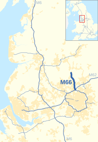
The M66, also known as the Bury Easterly Bypass, is a motorway in Lancashire and Greater Manchester, England. It is 8 miles (13 km) long and provides part of the route between the M62 and M60 motorways and the M65, with the rest being provided by the A56.

<span class="mw-page-title-main">M602 motorway</span> Motorway in England

The M602 motorway is a 4-mile (6.4 km) motorway, leading traffic into Salford, Greater Manchester, England, towards Manchester and by-passing the suburban town of Eccles.

<span class="mw-page-title-main">M606 motorway</span> Motorway in England

The M606 is a 3-mile (4.8 km) stretch of motorway in West Yorkshire, England. Called the Bradford Spur motorway, the M606 leaves the M62 motorway at junction 26, near Cleckheaton, and heads into Bradford, to join the A6177 Bradford Ring Road. It is officially named the "Bradford South Radial Motorway" and was opened in 1973.

<span class="mw-page-title-main">A56 road</span> Road in England

The A56 is a road in England which extends between the city of Chester in Cheshire and the village of Broughton in North Yorkshire. The road contains a mixture of single and dual carriageway sections, and traverses environments as diverse as the dense urban sprawl of inner city Manchester and the lightly populated region of rural east Lancashire. The road includes a short section of trunk road between the end of the M66 motorway near Ramsbottom and the M65 motorway west of Burnley.

<span class="mw-page-title-main">M63 motorway</span> Former road designation in Greater Manchester, England

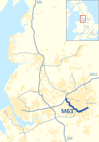
The M63 motorway was a major road in the United Kingdom. It was completely renumbered, in 1998, to become a substantial part of the M60 motorway which orbits part of Greater Manchester.

<span class="mw-page-title-main">A556 road</span> Road in Cheshire

The A556 is a road in England which extends from the village of Delamere in Cheshire West and Chester to the Bowdon Interchange in Cheshire East, bordering Greater Manchester. The road contains a mixture of single and dual carriageway sections and forms a large part of the route between Manchester and Chester. It also acts as a major access route to Chester/North Wales to the west and to Manchester to the east for the conurbation of towns and villages around the Dane Valley centering on Winsford and Northwich. The central part, which forms the Northwich Bypass between Davenham and Lostock Gralam, suffers because of the amount of commuter traffic from this area. The part of the route between the M6 motorway Junction 19 and the M56 motorway Junction 7 is a major route into Manchester and has been recently upgraded to a four-lane dual carriageway.

<span class="mw-page-title-main">A5103 road</span> Road in Manchester

The A5103 is a major road in England. It runs from Piccadilly Gardens in Manchester city centre to junction 3 of the M56 motorway and is one of Manchester's principal radial routes.

<span class="mw-page-title-main">Simister</span> Human settlement in England

Simister is a small suburb in the Metropolitan Borough of Bury, Greater Manchester, England. Historically part of Lancashire, it is located between the districts of Prestwich, Rhodes and Langley. Although the village's proximity to Manchester means the residential population is mainly made up of commuters, the village has a rural feel with much agricultural activity.

<span class="mw-page-title-main">Smart motorway</span> Designation of roads in the United Kingdom

A smart motorway, also known in Scotland as an intelligent transport system, is a section of motorway in the United Kingdom that employs active traffic management (ATM) techniques to increase capacity through the use of MIDAS technology including variable speed limits and occasionally hard shoulder running and ramp metering at busy times. They were developed at the turn of the 21st century as a cost-effective alternative to traditional carriageway widening, with intended benefits ranging from more reliable journey times to lower vehicle emissions. However, despite the risk of a collision occurring between two moving vehicles being found to be decreased, there has been an acknowledged rise in the incidence of collisions involving vehicles where at least one was stationary in the first few years following the widespread removal of the hard shoulder on the country's busiest sections of motorway. Smart motorways garnered intense criticism from politicians, police representatives and motoring organisations, particularly from 2020 onwards, after a surge in near miss incidents and dozens of fatalities were revealed, and as of April 2023, no new smart motorways will be built.

<span class="mw-page-title-main">Staithgate</span> Area of the City of Bradford, West Yorkshire, England

Staithgate, also called Staygate, is a community in the City of Bradford, West Yorkshire, England. The postcode serving Staithgate: BD6. The community is near the M606 motorway.

References

  1. "M60 Motorway". Highways Agency. Archived from the original on 15 November 2009. Retrieved 18 March 2012.
  2. "M60". Highways Agency. Archived from the original on 15 November 2009. Retrieved 30 October 2009.
  3. http://www.dft.gov.uk/stellent/groups/dft_transstats/documents/downloadable/dft_transstats_038887.pdf dft.gov.uk
  4. "Speech by Minister of State for Transport, Dr Stephen Ladyman, delivered at the opening ceremony of the widened M60 junction 5-8". Department For Transport. 26 June 2006. Archived from the original on 17 July 2007. Retrieved 28 January 2008.
  5. "M60 Junctions 8-12 Managed Motorways". Highways Agency. Retrieved 19 December 2012.
  6. "M60 Junctions 15-12 Lane Gain". Highways Agency. Retrieved 19 December 2012.
  7. "North-West Smart Motorways - M60 junction 8 to M62 junction 20". Highways England. Retrieved 30 June 2020.
  8. "M68 Middleton Link". Pathetic motorways. Retrieved 30 April 2022.
  9. "M62 Stretford-Eccles Bypass". Pathetic motorways. Retrieved 30 April 2022.
  10. "M63 Manchester South Orbital". Pathetic motorways. Retrieved 30 April 2022.
  11. "M60". CBRD. Retrieved 8 April 2018.
  12. "Traffic England Live Traffic Condition Map". Locations extracted from Traffic Camera Popup identifier text. Highways Agency. p. 1. Archived from the original on 10 February 2012. Retrieved 30 October 2009.
  13. "M60 fatal crash: Car chased by police drove wrong way on motorway". BBC. 28 May 2021. Retrieved 29 May 2021.
Template:Attached KML/M60 motorway
KML is from Wikidata

Further reading